707:
683:
695:
755:
206:
There were over 20 rail tanks in total, many converted LNWR tenders, despatched from the wharf at a rate of about 100 a month and left in sidings along the route. Water was sparse up the line, but here at the wharf a hillside spring fed a tank which was located at Sheep
Pasture bottom, across the line from the workshops. Apart from repairing wagons and locomotives, the company stock list records that in 1859 two locomotives were built at the workshops, but in reality they were more likely assembled here, for from 1840 parts were being bought from the Union Foundry in
731:
257:
a number of varying versions), it would seem that a wagon loaded with lime and a brake van containing gunpowder broke free from a train, hurtling down the incline at speeds of up to 120 mph (190 km/h). Failing to take the bend at the bottom, they then ran across the site, jumping across both the canal (damaging the bank) and the double tracks of the
Midland Railway before one of the canisters exploded in the adjacent field. Minutes later the London passenger train passed. Wreckage seen in the catch pit today dates from a further runaway in the 1950s.
647:
671:
743:
635:
719:
237:
junction with the
Manchester, Buxton, Matlock and Midlands Junction". However, it took another decade before horse power on the High Peak Railway was entirely replaced by steam. Following this connection, and the development of the Midland Line through to Manchester, more and more traffic took this route. Tonnage rates on the canal were lowered to attract trade, but competition was fierce, not helped by the eventual selling of the Cromford Canal to the railway company in 1852. A second collapse of the
119:
402:
410:
504:
103:
143:
159:, with awning over the canal, still stands on the west bank of the canal, a small distance from the workshop complex. From here the double-tracked line ran beside the workshops and up the steep Sheep Pasture incline. Prior to the construction of this larger transit shed, use was made of another shed the other side of the workshops, which opened onto the river. This later became a locomotive shed, but has now been demolished, and lies beyond the picnic area.
95:
544:
79:
19:
659:
127:
1977:
1431:
135:
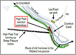
432:"two exchange sidings are provided on the down side of the main line and from these the High Peak line turns off through the woods, on a rising gradient of 1 in 200, to Cromford Sidings , at the foot of Sheep Pasture incline, which is a mile distant from the junction. The first 500 yards are worked as a siding, after which a staff section extends to the foot of the incline."
568:
that the cast iron, fish-bellied rails on either side of the inspection pit form the oldest length of railway line in the world still in its original position. Other items of particular interest, as indicated in the
Visitors Guide, include a drill, chain bays, an old photograph, line tools, the forge and bellows, beam engine parts, a joiner's bench, and an oil tank.
323:"). It is so labelled on the 1899 edition of the 25" OS map (revised 1896), where the former term refers to the main line junction, while the latter refers to the wharf area. The 1884 edition of the 25" OS maps also shows a "Junction Inn" on the towpath side opposite the wharf, though by the 1899 edition this had disappeared due to a realignment of the main line.
393:(Sigma Press, 2006), whilst correctly stating that "the Cromford end of the (High Peak) railway was connected at High Peak Junction to the (Midland) main line", the author's diagram shows a direct link from here, the foot of Sheep Pasture incline, continuing directly over the canal to the adjacent mainline. The difference in height could never have allowed this.
111:
552:
456:
The length of double track comprising the C&HPR siding (essentially main lain and loop) provided only the most basic of facilities, and operating flexibility was limited. If ever a main line train failed to pick up loaded wagons (a booked operation), or if the High Peak shunter was slow to remove
248:
From 1862 LNWR officials made regular inspections of the railway, and an inspection in June of this year led to an attempt to find a larger workshop site than that here at
Cromford. A level site at Ladmanlow, some 25 miles (40 km) along the line, was considered, but a report by Charles Mason the
241:
tunnel (2,966 yd (1.685 mi)) in 1900 – due to mining subsidence – rang the final death knell for the canal as an effective mode of transport. However, coal was still carried on this isolated section from
Hartshay to Lea and Cromford until 1944, when the whole canal was officially abandoned.
475:
The box closed in
October 1967, and the foundations and a significant amount of timber still survives, including rear posts and cross beams. The steel tubed Up Home bracket signal has been cut off at its base, and is still lying where it fell - presumably for intended collection later - although the
444:
At the
Junction, looking north, the signal box was located to the right of the Main Line. At this point there were in fact 5 parallel tracks, comprising - from west to east - the "down siding" (used by the C&HPR, with room for 35 wagons), the "High Peak Branch" (the main C&HPR line, operated
256:
High Peak
Junction lies at the bottom of the steep Sheep Pasture incline (some 1,320 yd (0.75 mi) in length at a gradient varying between 1:8 and 1:9), and following a runaway in 1888 a catch pit was constructed, the two lines passing either side of it. In this accident (of which there are
559:
Most of the railway buildings remains, namely offices and the old workshops where the early locomotives were built and serviced, and where water tanks were repaired. Beside the transit shed there is also the engine shed where the yard shunting engine resided. In 1985 the railway workshops and forge
436:
The 1858 Rule book, replaced in 1877 by one issued by the LNWR, refers to
Section 1 of the C&HPR (of 9 in total) being "High Peak Junction to Cromford", served by a square, black staff. Here, the name "High Peak Junction" refers to the actual junction with the main line, "Cromford" referring to
268:
The Act of 1855 provided powers to carry passengers, and this was done – on certain trains – using a brake van with seats. There was no proper timetable, but passengers could take advantage of the once-daily train which ran in both directions along the whole length of the 33-mile (53 km) line.
205:
had opened. It was to take 30 years before all horse motive-power was replaced by steam, but whilst there were engines on the line, water wagons had to be carried up the inclines from the wharf, for use by the stationary engines, and later by the locomotives, and for supply at isolated properties.
185:
The workshop complex here was largely built between 1826 and 1830 (making them the second oldest railway workshops in the world), specifically to serve the new line. There were also limited sidings here. The endless chains for the inclines, for instance, were made here from ¾ inch chain apparently
567:
In the workshops much remains virtually unchanged since closure, with many items on display in the way of artifacts, and a leaflet to help identify them (although some items of equipment are so rare that the Visitors Guide admits that it has not been possible to identify them all). It is possible
421:
Construction of this branch line had followed a fair bit of argument as to who should finance it - the C&HPR or the Matlock (later Midland) Railway. The C&HPR ultimately agreed, on 19 January 1852, to build it at its own expense, but asked the Matlock Company for a siding at the junction,
252:
A timetable of 1874 showed some nine departures daily from the junction, although there was only one through train daily along the whole length of the line, a journey of some 5½ hours. Most of the others terminated at Hopton, but clearly all these workings passed through this Cromford wharf site.
150:
As first built, the C&HPR – built to standard gauge proportions after initial plans for it to be constructed as a canal route – originally terminated at this location, named in the original Act as "beside the Cromford Canal, at or near to Cromford", where freight was transferred between canal
213:
However, the railway was initially only a link in the canal network, and isolated from other railway lines. It terminated here at its southern end, and it was not until two decades later that physical connection was made with any main line, eliminating its dependence for trade on the canal. This
578:
Some 1/4 mile from the workshops and other railway buildings stands the canal-side Wharf Shed (the former transit shed), the 10-ton crane, and the weighhouse, the Shed itself being of major historical significance. Wagons could pass right through to the canopied area beyond. A sign prohibiting
289:
refers to the canal-side workshop complex at the foot of Sheep Pasture incline, during the operating life of the High Peak Railway the name "High Peak Junction" was officially that of the signal box and Junction with the Midland Railway main-line, which lay some ¾ mile away to the south-east.
236:
The new main line Midland Railway junction was brought into use on 21 February 1853, increasing the length of the C&HPR by 58 chains (about ¾ mile), and Bradshaw's Railway Manual of 1870 describes the whole undertaking as now running "from Peak Forest Canal to the Cromford Canal, and to a
530:
The section of line from the workshops down to the original junction, although part of the C&HPR, was not purchased - although it remains a right of way - and High Peak Junction, beside the Cromford Canal, is therefore the southern start point of the High Peak Trail, from where it heads
560:
were restored and opened to the public, and there is also an information centre, shop and small cafe for visitors. An audio guide of the site is available. The shop today is located in what was one of the offices, and the oil and lamp store. The room on the end was the drivers' mess room.
563:
Beyond what is now the picnic site there was once an engine shed (a former transit shed), used to house the locomotive used between here and the mainline junction. Opposite the old signal post was once a large water tank, used to fill the tenders which were then taken up the incline.
264:
Locomotives on the line were primarily sourced from Rowsley shed, but subsheds were also provided at Cromford, Middleton and Sheep Pasture. These provided both accommodation and routine minor maintenance, and provided for the section of line between High Peak Junction and Friden.
87:
706:
189:
At the time of the railway's opening, apart from on the inclines, horses were the main form of power, and only minerals and goods were carried. These goods, which included coal, were primarily for local communities along the route. The carriage of
426:
on 6 October of that year, asking for tenders to construct this line, 58 chains long (see illustration), the contract was let on 16 October, and opened the following year, running along a shelf above and largely parallel to the river Derwent.
682:
460:
The High Peak Junction signal box, designated "D22", is described as being located "E (Up) side of line 140m S of Lea Wood river bridge", at grid reference 32306 55495. Distances to neighbouring locations were given as :
417:
There was no Act of Parliament authorizing a branch line to connect the C&HPR to the Midland main line, but its construction and opening (on 21 February 1853) were confirmed in Section 6 of the C&HPR Act of 1855.
440:
A timetable of 1891 also uses this terminology, and shows a time of 10 minutes from Cromford to the Junction, with 20 minutes allowed in the uphill direction. This section was operated as OES, i.e. One Engine in Steam.
260:
The line prospered, and quarries were serviced at Hopton, Hoptonwood, Middleton Top & Longcliffe. Traffic was also generated at the Harboro Brick Works, Longliffe and the Derbyshire Firebrick Company at Friden.
634:
449:), the up Main Line, the down Main Line, and the Up Loop. The siding here, together with the adjoining High Peak Railway main-line, was used for shunting wagons by the engine in this section, and was known as
197:
Initially static steam engines powered the inclines, but in 1833 the first locomotive was acquired for the line, and as such was one of the country's earliest railways, coming only seven years after
620:
The whole site at High Peak Junction is easily accessed from the large public car-park at Lea Bridge, in Lea Road, from where a footbridge crosses the river Derwent, the railway, and the canal.
245:
Beside the transit shed a road crossed the junction extension line at an ungated crossing. A red iron plate on a post was turned 90 degrees to indicate "stop" to either the road or the railway.
511:
The High Peak Railway closed fully in 1967, and in 1971 the Peak Park Planning Board and Derbyshire County Council purchased for £1 the trackbed from the High Peak Junction workshops as far as
2020:
777:
583:, the Wharf Shed was converted to a residential centre in the early 1970s. It is available for hire to schools, youth and adult community groups, with room for groups of up to 24 people.
330:(ie. this being at the foot of the Sheep Pasture incline). This name was retained for that section of line beside the workshops and the signal, ie. where the brake wagons currently stand.
1100:
166:, opened on 29 May 1830, opening throughout in 1831. At this point in time the railway was isolated from any other railway lines, being connected only to canals at either end, namely the
249:
following month suggested only a small maintenance shop there. Given that 18 men were employed at Cromford, and that many of their children worked in Arkwright's mill, it was left here.
476:
arms and dolls are missing. A line of telegraph poles still runs from Cromford Meadows to the Junction, between the River Derwent and the railway line, though the wires have long gone.
215:
1367:
730:
921:
670:
742:
269:
Passengers were supposed to alight and walk up the inclines, but many risked the ride. A fatality in 1877 provided a reason to discontinue what was an unprofitable service.
2015:
2025:
1450:
617:
in order to maintain the water level in the Cromford canal. Originally conceived in 1844 following a very dry summer, the Pumphouse became operational in 1849.
1247:
1360:
754:
646:
712:
Two brake vans on display at Sheep Pasture bottom. Beyond the bridge in the distance the incline leads up the hill towards Black Rocks and Middleton.
2000:
694:
718:
1097:
1353:
1316:
2010:
1882:
194:
also played a predominant part, for this mineral was required in the manufacture of steel, and was found in abundance in this upland area.
1005:
918:
658:
2045:
1278:
1082:
599:
623:
From High Peak Junction walkers can follow the level canal tow-path in both directions, or take the High Peak Trail up the incline.
405:
Midland Railway plan showing the workshop at the base of the incline of the C&HPR and High Peak Junction south of Leawood Tunnel
1283:
1146:
688:
This sign shows the main line branch from the Junction proper running along the wharf, and passing to the right of the Wharf Shed.
230:). This was strictly the "High Peak Junction", this name not being used for this canal-side site until after closure of the line.
2030:
1917:
1624:
202:
2040:
1887:
1867:
73:
42:
82:
The site as shown on an old OS Map; the extremes of the map show the original northern wharf, and the southern weigh-house.
2035:
1486:
356:
The small goods yard and limited sidings to the north-west, beyond the workshops and parallel to the canal, were known as
223:
98:
The advertisement placed for the construction of the branch line from the Midland Railway Junction to the canal-side site.
1491:
1897:
1405:
640:
The canal-side Wharf Shed at High Peak Junction, a little distance from the workshops. The awning overhangs the canal.
603:
61:
962:
311:", as it was until the Junction line was built in 1852. (To canal users, the swing bridge at this point was known as
1501:
446:
1225:
1826:
1771:
1251:
614:
580:
1524:
383:
219:
1927:
1691:
1534:
401:
163:
2005:
1862:
118:
1821:
1211:
936:
483:
A map of 1930 showing both sites - High Peak (main line) Junction and Cromford Goods - can be seen here.
409:
130:
Gradient Post at the foot of Sheep Pasture Incline, Cromford and High Peak Railway, Derbyshire, England
579:
engines from entering the shed - there are timber beams and floors - is still displayed. Now owned by
503:
1892:
1660:
50:
531:
immediately uphill, passing through the tunnel and up Sheep Pasture incline towards Black Rocks and
1811:
1579:
950:
227:
102:
53:
1188:
1907:
1639:
1564:
1559:
1481:
610:
389:
The changing use of the name "High Peak Junction" still causes confusion today. For instance, in
273:
Some photos of locomotives operating at High Peak Junction and on the C&HPR can be seen here.
1288:
142:
523:, another long-distance walking/cycle trail, and the route continues northwards to Dowlow near
64:
also passes this point, and popular walks lead from here along the towpath in both directions.
1981:
1942:
1841:
1619:
1589:
1584:
572:
507:
The start of the High Peak Trail - looking back down to High Peak Junction from the A6 tunnel.
198:
179:
171:
122:
A 1966 view from the A6 bridge down the lower part of Sheep Pasture incline towards the wharf.
1079:
1831:
1721:
1629:
1609:
1569:
1539:
1529:
1410:
520:
94:
1264:
543:
78:
1877:
1846:
1836:
1756:
1736:
1696:
1594:
1549:
1496:
1471:
1455:
1420:
1395:
1104:
1086:
925:
498:
480:
A photo of a main line locomotive passing the C&HPR exchange sidings can be seen here
304:
57:
18:
1027:
138:
Immediately above the bridge is the Sheep Pasture catch-pit built to trap runaway wagons.
1128:
1796:
1786:
1776:
1766:
1731:
1716:
1544:
1519:
1415:
1150:
516:
342:
167:
86:
46:
126:
1994:
1963:
1947:
1872:
1801:
1751:
1726:
1686:
1445:
1400:
586:
532:
346:
175:
515:, and it was turned it into the High Peak Trail. At Parsley Hay it is joined by the
1816:
1806:
1791:
1781:
1701:
1634:
1574:
1476:
1345:
156:
276:
Photos taken on the last day of operation, Sunday 30 April 1967, can be seen here.
178:
in the north. Cromford Canal had previously been finished in 1794 and linked Sir
1912:
1746:
1711:
1706:
1670:
1614:
1604:
512:
134:
1293:
1115:
594:
A 6-mile (9.7 km) long section of the Cromford canal between Cromford and
1665:
1430:
1376:
1308:
1298:
1199:
966:
34:
1331:
1318:
1303:
326:
A table dated 1891 detailing "Particulars of Gradients" for the line records
1937:
1932:
1922:
1761:
1741:
1655:
1390:
1006:"Photograph of Cromford High Peak Railway Railway Archive Album Image 34037"
595:
238:
191:
60:, a 17 miles (27 km) trail for walkers, cyclists and horse riders. The
1131:
Hand-book and Appendix of Stations, Junctions, Sidings, Collieries, &c.
1554:
676:
The watertank was used to fill special wagons, for transport up the line.
413:"High Peak Junction" with the Midland Railway, as shown on an old OS map.
337:, whilst Rimmer, an authority on the railway, refers to the main site as
30:
1174:
951:
Discovering Derbyshire & the Peak District : High Peak junction
748:
The top of Sheep Pasture incline, which leads up from High Peak Junction
1599:
736:
Railway End swingbridge across the Cromford Canal at High Peak Junction
38:
1248:"Cromford Canal: Site of Special Scientific Interest, Natural England"
585:
Note that "Cromford Wharf Shed" is here, not at the Canal terminus by
110:
524:
146:
Rope-hauled wagons crossing near the mid-point of the incline in 1964
551:
1294:
Photos of the Cromford & High Peak Railway, taken in the 1960s
1212:"David Heys steam diesel photo collection - 12 - HOLBECK SHED 55A"
550:
542:
502:
408:
400:
207:
152:
141:
133:
125:
117:
109:
101:
93:
85:
77:
17:
382:, although this name was that used for the main line sidings at
1349:
300:
Over the years this workshop site has had various names :
56:, designated in 2001, and today marks the southern end of the
41:, is the name now used to describe the site where the former
1048:
341:, although today this name is used to refer to the original
571:
The former C&HPR agent's house can be seen next to the
45:(C&HPR), whose workshops were located here, meets the
811:
The Cromford & High Peak Railway (New Edition, 1985)
216:
Manchester, Buxton, Matlock and Midland Junction Railway
422:
which was provided. Following an advertisement in the
664:
The workshops and offices at High Peak Junction today
315:.) From at least 1900 onwards maps label this site "
22:
Location of High Peak Junction in Derbyshire, England
1058:
1056:
1956:
1855:
1679:
1648:
1510:
1464:
1438:
1383:
2021:Sites of Special Scientific Interest in Derbyshire
106:A view inside the old workshop, showing the forge.
457:empties, the result was considerable congestion.
1304:Friends of Cromford Canal - A comprehensive site
360:. The Rule Book and timetables refer simply to
285:As has been mentioned, although today the name
1028:"Cromford & High Peak Railway - PlumbLoco"
114:Specimen fish-belly rail laid on stone blocks.
1361:
162:This first section of the line, from here to
8:
946:
944:
919:History page on Derby County Council website
307:maps of 1880 and 1884 the site is labelled "
778:Cromford Canal Conservation Management Plan
1368:
1354:
1346:
1170:
1168:
860:
858:
856:
854:
848:High Peak Junction Workshops Visitor Guide
724:The centre as viewed from across the canal
378:(1934) incorrectly refers to this site as
182:’s mills to the national waterway system.
2016:Closed railway lines in the East Midlands
803:
801:
799:
797:
795:
793:
791:
789:
787:
785:
349:, in Cromford. For this reason the name
186:supplied by Pritt & Co of Liverpool.
2026:Tourist attractions of the Peak District
1184:
1182:
897:
895:
827:
825:
823:
821:
68:History as part of the High Peak Railway
1299:YouTube - The Transit Shed now and then
770:
630:
547:A schematic diagram of the site today.
90:A diagram of High Peak Junction today.
1883:Derbyshire Dales Narrow Gauge Railway
1030:. Plumbloco.smugmug.com. 30 July 2013
652:Another good view of the transit shed
471:"Cromford Goods (C&HP) - 1294yd".
151:barges and railway wagons. The large
7:
1279:High Peak Junction Workshops website
905:The Cromford & High Peak Railway
868:The Cromford & High Peak Railway
602:(SSSI), and also forms part of the
397:The signalbox and main line junction
391:"Peak District Walking on the Level"
1284:Derwent Valley Heritage Way website
600:Site of Special Scientific Interest
1063:N Jones & J M Bentley (2001).
535:, from where cycles can be hired.
430:A description of 1934 states that
294:referred to that adjacent siding.
14:
1098:Derbyshire County Council website
527:, a total distance of 17½ miles.
1975:
1943:Royal Crown Derby Visitor Centre
1429:
1377:Places of Interest in Derbyshire
1228:. Ponies.me.uk. 22 February 1999
760:A cutting on the High Peak Trail
753:
741:
729:
717:
705:
693:
681:
669:
657:
645:
633:
468:"Whatstandwell Sidings - 1485yd"
2001:Early British railway companies
1066:Cromford and High Peak Junction
988:Nickleson & Barnes (1971).
882:Blakemore & Mosley (2003).
613:, built to pump water from the
609:Another adjacent attraction is
335:Cromford Wharf of the C&HPR
281:Alternative names for this site
203:Stockton and Darlington Railway
1868:Cromford and High Peak Railway
1492:Derby Museum & Art Gallery
465:"Cromford Sidings - 1mi 516yd"
74:Cromford and High Peak Railway
43:Cromford and High Peak Railway
1:
1923:Millennium Walkway, New Mills
1487:Buxton Museum and Art Gallery
991:Railways in the Peak District
885:Railways of the Peak District
589:, now known as Cromford Wharf
555:Nearby is Leawood pump house.
2011:Rail transport in Derbyshire
1451:Chesterfield's Crooked Spire
1439:Churches and religious sites
1309:A video of Leawood pumphouse
1200:Derby Signalling archaeology
1918:Midland Railway – Butterley
1898:Ecclesbourne Valley Railway
1585:Longdendale Reservoir Chain
1391:Ardotalia (Melandra Castle)
604:Derwent Valley Heritage Way
488:Closure, and the area today
333:Jones and Bentley refer to
62:Derwent Valley Heritage Way
2062:
2046:Railway museums in England
1465:Museums and cultural sites
1384:Castles and military sites
1226:"Old Ordnance Survey Maps"
598:is listed as a Biological
496:
451:High Peak Junction sidings
292:High Peak Junction sidings
71:
1972:
1827:Swarkestone Hall Pavilion
1427:
1265:Leawood Pumphouse website
1080:Derwent Valley Mills site
937:Bygone Derbyshire website
581:Derbyshire County Council
371:beside the transit shed.
328:"Bottom of Sheep Pasture"
1671:Nine Ladies Stone Circle
1189:Derby Signalling website
384:Cromford railway station
367:The 1900 O.S. Map marks
353:is also sometimes used.
214:connection was with the
2031:Transport in Derbyshire
1928:National Tramway Museum
1535:Buxton Pavilion Gardens
1502:Pickford's House Museum
1863:Barrow Hill Roundhouse
1856:Transport and industry
1175:Railway Magazine, 1934
1116:Cromford canal history
994:. Dalesman Publishing.
888:. Atlantic Publishing.
871:. David & Charles.
700:The visitor area today
556:
548:
508:
414:
406:
343:Wharf at the Canal end
290:Consequently the name
170:in the south, and the
147:
139:
131:
123:
115:
107:
99:
91:
83:
23:
2041:Museums in Derbyshire
1982:Derbyshire portal
1822:Sutton Scarsdale Hall
1649:Prehistoric landmarks
1254:on 27 September 2007.
1127:Henry Oliver (1894).
1069:. Foxline Publishing.
1049:Old O.S. Maps website
554:
546:
506:
437:the canal-side site.
412:
404:
226:stations (now on the
145:
137:
129:
121:
113:
105:
97:
89:
81:
21:
2036:Canals in Derbyshire
1893:Derwent Valley Mills
1289:High Peak Trail site
838:. The History Press.
369:Cromford Goods Wharf
51:Derwent Valley Mills
1625:Shining Cliff Woods
1580:Ladybower Reservoir
1328: /
963:"Derbysulzers site"
493:The High Peak Trail
228:Derwent Valley line
218:at a point between
54:World Heritage Site
1908:Leawood Pump House
1903:High Peak Junction
1640:Treak Cliff Cavern
1565:Heights of Abraham
1560:Foremark Reservoir
1513:and outdoor spaces
1482:Buxton Opera House
1332:53.1002°N 1.5334°W
1103:2009-05-29 at the
1085:2008-10-15 at the
924:2011-09-27 at the
902:Rimmer, A (1956).
808:Rimmer, A (1985).
611:Leawood Pump House
557:
549:
519:, now part of the
509:
415:
407:
317:High Peak Junction
287:High Peak Junction
148:
140:
132:
124:
116:
108:
100:
92:
84:
27:High Peak Junction
24:
1988:
1987:
1888:Derwent Reservoir
1842:Willersley Castle
1661:Hob Hurst's House
1590:Longdendale Trail
1511:Natural landmarks
865:Marshall (1982).
321:Highpeak Junction
313:Railwayend bridge
199:George Stephenson
180:Richard Arkwright
172:Peak Forest Canal
49:. It lies within
2053:
1980:
1979:
1978:
1832:Thornbridge Hall
1812:St Helen's House
1722:Chatsworth House
1692:Barlborough Hall
1630:Speedwell Cavern
1610:Ogston Reservoir
1570:Howden Reservoir
1540:Carsington Water
1530:Blue John Cavern
1433:
1411:Melbourne Castle
1370:
1363:
1356:
1347:
1343:
1342:
1340:
1339:
1338:
1337:53.1002; -1.5334
1333:
1329:
1326:
1325:
1324:
1321:
1267:
1262:
1256:
1255:
1250:. Archived from
1244:
1238:
1237:
1235:
1233:
1222:
1216:
1215:
1208:
1202:
1197:
1191:
1186:
1177:
1172:
1163:
1162:
1160:
1158:
1149:. Archived from
1143:
1137:
1136:
1124:
1118:
1113:
1107:
1095:
1089:
1077:
1071:
1070:
1060:
1051:
1046:
1040:
1039:
1037:
1035:
1024:
1018:
1017:
1015:
1013:
1002:
996:
995:
985:
979:
978:
976:
974:
965:. Archived from
959:
953:
948:
939:
934:
928:
916:
910:
909:
908:. Oakwood Press.
899:
890:
889:
879:
873:
872:
862:
849:
846:
840:
839:
829:
816:
815:
814:. Oakwood Press.
805:
780:
775:
757:
745:
733:
721:
709:
697:
685:
673:
661:
649:
637:
521:Tissington Trail
517:Ashbourne branch
380:Cromford Sidings
376:Railway Magazine
2061:
2060:
2056:
2055:
2054:
2052:
2051:
2050:
1991:
1990:
1989:
1984:
1976:
1974:
1968:
1952:
1878:Derby Silk Mill
1851:
1847:Wingfield Manor
1837:Tissington Hall
1757:Hartington Hall
1737:Elvaston Castle
1697:Bradbourne Hall
1675:
1644:
1595:Longshaw Estate
1550:Derby Arboretum
1512:
1506:
1497:Devonshire Dome
1472:Buxton Crescent
1460:
1456:Derby Cathedral
1434:
1425:
1421:Pilsbury Castle
1406:Duffield Castle
1396:Bolsover Castle
1379:
1374:
1336:
1334:
1330:
1327:
1322:
1319:
1317:
1315:
1314:
1275:
1270:
1263:
1259:
1246:
1245:
1241:
1231:
1229:
1224:
1223:
1219:
1210:
1209:
1205:
1198:
1194:
1187:
1180:
1173:
1166:
1156:
1154:
1147:"Midland Lines"
1145:
1144:
1140:
1126:
1125:
1121:
1114:
1110:
1105:Wayback Machine
1096:
1092:
1087:Wayback Machine
1078:
1074:
1062:
1061:
1054:
1047:
1043:
1033:
1031:
1026:
1025:
1021:
1011:
1009:
1008:. Aditnow.co.uk
1004:
1003:
999:
987:
986:
982:
972:
970:
961:
960:
956:
949:
942:
935:
931:
926:Wayback Machine
917:
913:
901:
900:
893:
881:
880:
876:
864:
863:
852:
847:
843:
832:Potter (2003).
831:
830:
819:
807:
806:
783:
776:
772:
768:
761:
758:
749:
746:
737:
734:
725:
722:
713:
710:
701:
698:
689:
686:
677:
674:
665:
662:
653:
650:
641:
638:
629:
541:
501:
499:High Peak Trail
495:
490:
399:
351:High Peak Wharf
305:Ordnance Survey
283:
76:
70:
58:High Peak Trail
12:
11:
5:
2059:
2057:
2049:
2048:
2043:
2038:
2033:
2028:
2023:
2018:
2013:
2008:
2003:
1993:
1992:
1986:
1985:
1973:
1970:
1969:
1967:
1966:
1960:
1958:
1954:
1953:
1951:
1950:
1945:
1940:
1935:
1930:
1925:
1920:
1915:
1910:
1905:
1900:
1895:
1890:
1885:
1880:
1875:
1870:
1865:
1859:
1857:
1853:
1852:
1850:
1849:
1844:
1839:
1834:
1829:
1824:
1819:
1814:
1809:
1804:
1799:
1797:Radbourne Hall
1794:
1789:
1787:Oakhurst House
1784:
1779:
1777:Melbourne Hall
1774:
1769:
1767:Kedleston Hall
1764:
1759:
1754:
1749:
1744:
1739:
1734:
1732:Ednaston Manor
1729:
1724:
1719:
1717:Castleton Hall
1714:
1709:
1704:
1699:
1694:
1689:
1683:
1681:
1677:
1676:
1674:
1673:
1668:
1663:
1658:
1652:
1650:
1646:
1645:
1643:
1642:
1637:
1632:
1627:
1622:
1620:Poole's Cavern
1617:
1612:
1607:
1602:
1597:
1592:
1587:
1582:
1577:
1572:
1567:
1562:
1557:
1552:
1547:
1545:Creswell Crags
1542:
1537:
1532:
1527:
1522:
1520:Alport Castles
1516:
1514:
1508:
1507:
1505:
1504:
1499:
1494:
1489:
1484:
1479:
1474:
1468:
1466:
1462:
1461:
1459:
1458:
1453:
1448:
1442:
1440:
1436:
1435:
1428:
1426:
1424:
1423:
1418:
1416:Peveril Castle
1413:
1408:
1403:
1398:
1393:
1387:
1385:
1381:
1380:
1375:
1373:
1372:
1365:
1358:
1350:
1312:
1311:
1306:
1301:
1296:
1291:
1286:
1281:
1274:
1273:External links
1271:
1269:
1268:
1257:
1239:
1217:
1203:
1192:
1178:
1164:
1153:on 4 July 2011
1138:
1119:
1108:
1090:
1072:
1052:
1041:
1019:
997:
980:
954:
940:
929:
911:
891:
874:
850:
841:
835:Cromford Canal
817:
781:
769:
767:
764:
763:
762:
759:
752:
750:
747:
740:
738:
735:
728:
726:
723:
716:
714:
711:
704:
702:
699:
692:
690:
687:
680:
678:
675:
668:
666:
663:
656:
654:
651:
644:
642:
639:
632:
628:
625:
540:
539:The site today
537:
497:Main article:
494:
491:
489:
486:
485:
484:
481:
473:
472:
469:
466:
398:
395:
358:Cromford Goods
339:Cromford Wharf
282:
279:
278:
277:
274:
168:Cromford Canal
72:Main article:
69:
66:
47:Cromford Canal
13:
10:
9:
6:
4:
3:
2:
2058:
2047:
2044:
2042:
2039:
2037:
2034:
2032:
2029:
2027:
2024:
2022:
2019:
2017:
2014:
2012:
2009:
2007:
2006:Peak District
2004:
2002:
1999:
1998:
1996:
1983:
1971:
1965:
1964:Well dressing
1962:
1961:
1959:
1955:
1949:
1948:Stainsby Mill
1946:
1944:
1941:
1939:
1936:
1934:
1931:
1929:
1926:
1924:
1921:
1919:
1916:
1914:
1911:
1909:
1906:
1904:
1901:
1899:
1896:
1894:
1891:
1889:
1886:
1884:
1881:
1879:
1876:
1874:
1873:Cromford Mill
1871:
1869:
1866:
1864:
1861:
1860:
1858:
1854:
1848:
1845:
1843:
1840:
1838:
1835:
1833:
1830:
1828:
1825:
1823:
1820:
1818:
1815:
1813:
1810:
1808:
1805:
1803:
1802:Renishaw Hall
1800:
1798:
1795:
1793:
1790:
1788:
1785:
1783:
1780:
1778:
1775:
1773:
1772:Longford Hall
1770:
1768:
1765:
1763:
1760:
1758:
1755:
1753:
1752:Hardwick Hall
1750:
1748:
1745:
1743:
1740:
1738:
1735:
1733:
1730:
1728:
1727:Coxbench Hall
1725:
1723:
1720:
1718:
1715:
1713:
1710:
1708:
1705:
1703:
1700:
1698:
1695:
1693:
1690:
1688:
1687:Alfreton Hall
1685:
1684:
1682:
1680:Stately homes
1678:
1672:
1669:
1667:
1664:
1662:
1659:
1657:
1654:
1653:
1651:
1647:
1641:
1638:
1636:
1633:
1631:
1628:
1626:
1623:
1621:
1618:
1616:
1613:
1611:
1608:
1606:
1603:
1601:
1598:
1596:
1593:
1591:
1588:
1586:
1583:
1581:
1578:
1576:
1573:
1571:
1568:
1566:
1563:
1561:
1558:
1556:
1553:
1551:
1548:
1546:
1543:
1541:
1538:
1536:
1533:
1531:
1528:
1526:
1523:
1521:
1518:
1517:
1515:
1509:
1503:
1500:
1498:
1495:
1493:
1490:
1488:
1485:
1483:
1480:
1478:
1475:
1473:
1470:
1469:
1467:
1463:
1457:
1454:
1452:
1449:
1447:
1446:Anchor Church
1444:
1443:
1441:
1437:
1432:
1422:
1419:
1417:
1414:
1412:
1409:
1407:
1404:
1402:
1401:Codnor Castle
1399:
1397:
1394:
1392:
1389:
1388:
1386:
1382:
1378:
1371:
1366:
1364:
1359:
1357:
1352:
1351:
1348:
1344:
1341:
1310:
1307:
1305:
1302:
1300:
1297:
1295:
1292:
1290:
1287:
1285:
1282:
1280:
1277:
1276:
1272:
1266:
1261:
1258:
1253:
1249:
1243:
1240:
1227:
1221:
1218:
1213:
1207:
1204:
1201:
1196:
1193:
1190:
1185:
1183:
1179:
1176:
1171:
1169:
1165:
1152:
1148:
1142:
1139:
1134:
1133:
1130:
1123:
1120:
1117:
1112:
1109:
1106:
1102:
1099:
1094:
1091:
1088:
1084:
1081:
1076:
1073:
1068:
1065:
1059:
1057:
1053:
1050:
1045:
1042:
1029:
1023:
1020:
1007:
1001:
998:
993:
990:
984:
981:
969:on 1 May 2009
968:
964:
958:
955:
952:
947:
945:
941:
938:
933:
930:
927:
923:
920:
915:
912:
907:
904:
898:
896:
892:
887:
884:
878:
875:
870:
867:
861:
859:
857:
855:
851:
845:
842:
837:
834:
828:
826:
824:
822:
818:
813:
810:
804:
802:
800:
798:
796:
794:
792:
790:
788:
786:
782:
779:
774:
771:
765:
756:
751:
744:
739:
732:
727:
720:
715:
708:
703:
696:
691:
684:
679:
672:
667:
660:
655:
648:
643:
636:
631:
626:
624:
621:
618:
616:
615:river Derwent
612:
607:
605:
601:
597:
592:
590:
588:
587:Cromford Mill
582:
576:
574:
569:
565:
561:
553:
545:
538:
536:
534:
533:Middleton Top
528:
526:
522:
518:
514:
505:
500:
492:
487:
482:
479:
478:
477:
470:
467:
464:
463:
462:
458:
454:
452:
448:
442:
438:
434:
433:
428:
425:
424:Derby Mercury
419:
411:
403:
396:
394:
392:
387:
385:
381:
377:
372:
370:
365:
363:
359:
354:
352:
348:
347:Cromford Mill
344:
340:
336:
331:
329:
324:
322:
318:
314:
310:
306:
301:
298:
297:
293:
288:
280:
275:
272:
271:
270:
266:
262:
258:
254:
250:
246:
243:
240:
234:
233:
229:
225:
224:Whatstandwell
221:
217:
211:
209:
204:
200:
195:
193:
187:
183:
181:
177:
176:Whaley Bridge
173:
169:
165:
160:
158:
154:
144:
136:
128:
120:
112:
104:
96:
88:
80:
75:
67:
65:
63:
59:
55:
52:
48:
44:
40:
36:
32:
28:
20:
16:
1902:
1817:Sudbury Hall
1807:Riber Castle
1792:Parwich Hall
1782:Norbury Hall
1702:Bradley Hall
1635:Thorpe Cloud
1575:Kinder Scout
1477:Buxton Baths
1313:
1260:
1252:the original
1242:
1232:14 September
1230:. Retrieved
1220:
1206:
1195:
1155:. Retrieved
1151:the original
1141:
1132:
1129:
1122:
1111:
1093:
1075:
1067:
1064:
1044:
1032:. Retrieved
1022:
1012:14 September
1010:. Retrieved
1000:
992:
989:
983:
971:. Retrieved
967:the original
957:
932:
914:
906:
903:
886:
883:
877:
869:
866:
844:
836:
833:
812:
809:
773:
622:
619:
608:
593:
584:
577:
570:
566:
562:
558:
529:
510:
474:
459:
455:
450:
445:by separate
443:
439:
435:
431:
429:
423:
420:
416:
390:
388:
379:
375:
374:An issue of
373:
368:
366:
361:
357:
355:
350:
338:
334:
332:
327:
325:
320:
316:
312:
308:
302:
299:
296:(See below.)
295:
291:
286:
284:
267:
263:
259:
255:
251:
247:
244:
235:
232:(See below.)
231:
212:
196:
188:
184:
161:
157:transit shed
149:
26:
25:
15:
1913:Magpie Mine
1747:Haddon Hall
1712:Calke Abbey
1707:Bretby Hall
1615:Peak Cavern
1605:Monsal Dale
1525:Black Rocks
1335: /
513:Parsley Hay
1995:Categories
1666:Minninglow
1320:53°06′01″N
1157:12 October
766:References
309:Railwayend
35:Derbyshire
1938:Peak Rail
1933:Odin Mine
1762:Ilam Park
1742:Eyam Hall
1656:Arbor Low
1323:1°32′00″W
1034:23 August
596:Ambergate
239:Butterley
192:limestone
1957:See also
1555:Dovedale
1101:Archived
1083:Archived
973:16 April
922:Archived
362:Cromford
220:Cromford
31:Cromford
1600:Mam Tor
627:Gallery
575:above.
345:beside
319:" (or "
164:Hurdlow
39:England
29:, near
525:Buxton
155:-side
447:staff
208:Derby
153:wharf
1234:2010
1159:2009
1036:2013
1014:2010
975:2009
222:and
303:On
201:'s
174:at
1997::
1181:^
1167:^
1055:^
943:^
894:^
853:^
820:^
784:^
606:.
591:.
573:A6
453:.
386:.
364:.
210:.
37:,
33:,
1369:e
1362:t
1355:v
1236:.
1214:.
1161:.
1135:.
1038:.
1016:.
977:.
Text is available under the Creative Commons Attribution-ShareAlike License. Additional terms may apply.