31:
270:
222:. It had 3,629 inhabitants as of 2017. Hornopirén is an important tourist stop on Chile’s Carretera Austral (Highway 7) and serves as the departure point for the bi-modal car ferry system on the Carretera Austral through the Palena Province. It also provides access to Hornopirén National Park and the Northern Patagonia Fjordlands. Boat trips run from the town to remote hot springs and campgrounds in the fjordlands.
340:
30:
330:
311:
335:
350:
345:
48:
304:
297:
192:
36:
177:
269:
219:
281:
277:
83:
239:
211:
93:
184:
167:
324:
215:
207:
113:
103:
63:
50:
162:
285:
341:
Populated places in the fjords and channels of Chile
191:
174:
161:
153:
148:
140:
132:
124:
119:
109:
99:
89:
79:
21:
245:(in Spanish). National Statistics Institute. 2019
305:
8:
240:"Ciudades, pueblos, aldeas y caceríos 2019"
312:
298:
18:
218:. It lies along the northern portion of
231:
190:
160:
147:
139:
118:
78:
27:
173:
152:
131:
123:
108:
98:
88:
7:
266:
264:
331:Populated places in Palena Province
284:. You can help Knowledge (XXG) by
14:
336:Populated coastal places in Chile
351:Los Lagos Region geography stubs
268:
29:
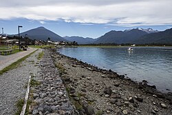
35:Seaside road of Hornopirén and
1:
206:is a town in the commune of
367:
346:Coasts of Los Lagos Region
263:
16:Place in Palena, Los Lagos
64:41.9662000°S 72.4706000°W
44:
28:
197:Country + town = 56 + 65
69:-41.9662000; -72.4706000
280:location article is a
144:15 m (49 ft)
176: • Summer (
136:Freddy Ibacache Muñoz
133: • Alcalde
60: /
187:(Chilean Daylight)
170:(Chilean Standard)
154: • Total
39:in the background.
37:Hornopirén Volcano
293:
292:
220:Carretera Austral
201:
200:
125: • Type
358:
314:
307:
300:
278:Los Lagos Region
272:
265:
255:
254:
252:
250:
244:
236:
181:
75:
74:
72:
71:
70:
65:
61:
58:
57:
56:
53:
33:
19:
366:
365:
361:
360:
359:
357:
356:
355:
321:
320:
319:
318:
261:
259:
258:
248:
246:
242:
238:
237:
233:
228:
212:Palena Province
175:
68:
66:
62:
59:
54:
51:
49:
47:
46:
40:
24:
17:
12:
11:
5:
364:
362:
354:
353:
348:
343:
338:
333:
323:
322:
317:
316:
309:
302:
294:
291:
290:
273:
257:
256:
230:
229:
227:
224:
216:southern Chile
199:
198:
195:
189:
188:
182:
172:
171:
165:
159:
158:
155:
151:
150:
146:
145:
142:
138:
137:
134:
130:
129:
126:
122:
121:
117:
116:
111:
107:
106:
101:
97:
96:
91:
87:
86:
81:
77:
76:
42:
41:
34:
26:
25:
22:
15:
13:
10:
9:
6:
4:
3:
2:
363:
352:
349:
347:
344:
342:
339:
337:
334:
332:
329:
328:
326:
315:
310:
308:
303:
301:
296:
295:
289:
287:
283:
279:
274:
271:
267:
262:
241:
235:
232:
225:
223:
221:
217:
213:
209:
205:
196:
194:
186:
183:
179:
169:
166:
164:
156:
143:
135:
128:Municipalidad
127:
115:
112:
105:
102:
100:Municipalidad
95:
92:
85:
82:
73:
55:72°28′14.16″W
52:41°57′58.32″S
45:Coordinates:
43:
38:
32:
20:
286:expanding it
275:
260:
247:. Retrieved
234:
203:
202:
249:November 1,
67: /
325:Categories
226:References
204:Hornopirén
149:Population
120:Government
23:Hornopirén
208:Hualaihué
193:Area code
185:UTC−03:00
168:UTC−04:00
163:Time zone
141:Elevation
114:Hualaihué
104:Hualaihué
84:Los Lagos
90:Province
110:Comuna
94:Palena
80:Region
276:This
243:(PDF)
157:3,629
282:stub
251:2020
210:in
178:DST
327::
214:,
313:e
306:t
299:v
288:.
253:.
180:)
Text is available under the Creative Commons Attribution-ShareAlike License. Additional terms may apply.