474:
397:
597:. There were over 300 individual flows with an average volume of 500–600 cubic kilometres (120–140 cu mi). This series of eruptions were unrelated to the volcanism occurring in the nearby Cascade Range. The flows gained an eventual thickness of around 1.8 kilometres (5,900 ft). The weight of the newly erupted basalt caused the underlying crust to subside. North-to-south compression of the basalt group caused the Horse Heaven Hills to begin slowly uplifting around 15 million years ago. The compression has a rate of approximately 1 millimetre (0.039 in) per year.
601:
95:
102:
833:
285:
765:
38:
550:
886:, and other animals once populated the hills. The majority of the skeletal fragments were found in canyons under fine silt and sand. They date from 7,000 to 12,000 years old, with some specimens found to be even older. The higher altitudes where the specimens were found indicate the now extinct animals survived the Missoula Floods that occurred toward the end of the
860:. They spent a short time as the main grazing animal within the hills, but horses have largely been pushed out of the range, both by removal and by farming activity. Deer can still be found in small numbers throughout the Horse Heaven Hills. The Yakama Nation has recently reintroduced pronghorn sheep near Satus Pass.
772:
Irrigation from the Yakima and
Columbia Rivers has recently made parts of the Horse Heaven Hills into an important agricultural region. Where there is no irrigation, dryland wheat is grown. The irrigation network continues to be expanded. An example of this is a project in 2016 that allowed for 4,000
576:
in the hills above
Prosser after a flour mill was built there in 1887. A couple of small towns were established in the late-19th Century and early-20th Century, such as Bickleton and Horse Heaven. Bickleton was first established as a trading post, with the rest of the town developing around it. Horse
440:
The Horse Heaven Hills may serve as a boundary that creates air pollution problems in the Tri-Cities. On hot, calm days during the summer, it is believed that air moves slowly from the north across the Tri-Cities, ponding at the base of the range. It is believed that this is one of the things pushing
855:
Upon the arrival of horses, the Native
Americans likely used them for hunting, depleting the existing game, including bison, pronghorn sheep, and elk. Despite being named for being a horse heaven, wild horses can only be seen grazing in some portions of the Horse Heaven Hills, especially to the west
457:
The Horse Heaven Hills and surrounding areas have been inhabited since long before
European colonization, though human populations within the hills themselves has remained quite low compared to the neighboring valleys. The range served as an important boundary between the ranges of different Native
436:
The area is among the driest wheat growing regions in the world. Strong winds cause extensive soil erosion on farmland, with blowing dust exceeding federal air quality standards twenty times over a ten-year period. These events can reduce visibility to near zero and force the closure of highways in
540:
in the fall of 1805. The Horse Heaven Hills are noted in their journal entry on
October 16 as "a range of high Countrey which runs from S. W & N E and is on the opposite Side about 2 miles distant from the Columbia". In the following days, the expedition continued down the Columbia River as it
557:
The first wagon trains entered the nearby Yakima Valley in 1853. The local natives were friendly to the settlers, but relations between the two groups of settlers and the entirety of eastern
Washington (including the Horse Heaven Hills) was closed to white settlement. The ban was lifted after a
428:
semi-arid, and much drier than areas to the west of the
Cascade Crest. Most precipitation falls during the winter, with the dry season occurring during the summer. Despite the low average rainfall, summer thunderstorms can stall over the hills causing flash flooding. Flooding was most severe in
271:
Native grasses and shrubs dominate the range, which is mostly treeless. Flora also includes native flowers, some of which are listed as being threatened. There were at one time large numbers of big game roaming the hills, but many of them were hunted to extinction. Horses briefly roamed widely
823:
The
Juniper Canyon Wind Project near Bickleton started construction in 2010 in two phases. The first phase is capable of producing 150 megawatts, with the second portion adding 100 megawatts. It is also tied into the Bonneville Power Administration system through a newly built 20.4 miles
647:. The surface of Lake Lewis reached a peak of around 1,200 feet (370 m) above today's sea level before all of the water flowed through Wallula Gap, which constrained the flow so that only about a fifth of the water could pass through in a day. The lake extended as far as Yakima and
815:
generating electricity for the region. The Nine Mile Canyon
Project located to the south of Kennewick and Finley covers 75 acres (30 ha) and is capable of producing 95.9 megawatts. This project was built in three phases between 2002 and 2007. It is tied into the
419:
Rainfall values are low, ranging from 9 inches (230 mm) in lower portions of the range to near 20 inches (510 mm) annually in higher elevations to the west. This is because the hills lie east of the
Cascades. The Cascade Mountains cause a
465:. In the two centuries following the exploration missions, the human use of the Horse Heaven Hills transitioned from mostly hunting and grazing toward the modern agriculture we see in the region today, with larger cities growing on the periphery.
2228:
1813:
1954:
2184:
1724:
686:
formation. The soils are nutrient-poor and free draining. There are small, deep canyons in the slopes of the range and other areas where the Columbia River Basalt Group is exposed. The north slope has numerous
2225:
718:
was located on the same fault as the Horse Heaven Hills. Despite being on the same fault line, the name Horse Heaven Hills is not applied to the hills created by the fault to the east of Wallula Gap.
776:
Where irrigation water is accessible, a variety of crops can be grown. Some of these include potatoes, onions, and carrots in the ground. This also provides opportunities for orchards and wineries.
730:
has turned portions of the range, which have a semi-arid climate, into a region that can grow a wide variety of crops. Most of the irrigated land is on the southern slope of the Horse Heaven Hills.
663:
that they were embedded in became stuck on the slopes of the Horse Heaven Hills and nearby ridges and later melted. After passing through Wallula Gap, the water was blocked at the entrance of the
2475:
1803:
773:
acres (1,600 ha) more land to be irrigated. Projects like this have been opposed by wheat growers that lease the land they grow on, because they lose out to farmers who grow other crops.
1946:
1496:
2176:
2728:
2409:
1431:
473:
1873:
408:
The Horse Heaven Hills are located in one of the hottest parts of Washington, sharing in the same semi-arid climate that is experienced in nearby cities such as the Tri-Cities and
852:, which is listed as imperiled. Invasive plant species have found a place in the Horse Heaven Hills in the absence of the large number of grazers who formerly roamed the region.
1714:
756:
purchased 14,500 acres of farmland in the Horse Heaven Hills for $ 171 million. The land is occupied by 100 Circle Farms, which produces potatoes for McDonald’s french fries.
237:
for centuries, who had settlements surrounding the Horse Heaven Hills. They used the range both as hunting grounds and as a geographic boundary between different tribes. The
1267:
1905:
2794:
437:
the hills. In the winter, the Horse Heaven Hills are subject to more snow than the surrounding valleys. This can lead to erosion issues when large amounts of snow melt.
2150:
2086:
381:
crossed the Horse Heaven Hills before I-82 was built, but that designation was truncated to Plymouth when the interstate was built along the same route as the highway.
2562:
1986:
972:
734:
565:, is credited with officially naming the Horse Heaven Hills in 1881. He first came to the region in 1857. Impressed by the knee-high grass that fed the large bands of
1153:
2799:
2789:
2468:
94:
2804:
558:
series of uprisings and battles. Early homestead parcels in the hills were 160 acres (65 ha), with all of the homestead parcels having been claimed by 1910.
2381:
2120:
2760:
968:
2275:
388:. The north slopes of the range drain to the Yakima River, a tributary of the Columbia. The rest of the range drains directly into the Columbia River itself.
2678:
2235:
Title 27: Alcohol, Tobacco and Firearms; Part 9 — American Viticultural Areas; Subpart C — Approved American Viticultural Areas. Retrieved January 30, 2008.
1848:
2515:
241:
represents the first known Europeans to reach the area. European settlement followed, with the introduction of modern farming techniques. In recent years,
2461:
1062:
726:
While sparsely populated, the Horse Heaven Hills have become an important region for agriculture and power generation within the state of Washington.
1237:
2567:
1097:
1464:
449:
and near the federal limit. High ozone levels are also being noted in Hermiston, though these do not reach the level being seen in the Tri-Cities.
315:
The north slope of the hills is especially steep, with the south slope being relatively gentle by comparison. This hills form the south end of the
149:
1990:
396:
1486:
1180:
2402:
1930:
1843:
1658:
1418:
1008:
482:
1332:
2784:
497:
tribe occupied the far northeastern portion of the hills in the general vicinity of Finley and Jump Off Joe. All of these tribes spoke the
2432:
1572:
1057:
2313:
890:. A research foundation was established to help fund research occurring at a dig site that is unearthing a mammoth south of Kennewick.
848:
is native to the region and common. Some of the flowers found in the area are listed at varying levels of endangerment, including the
234:
1688:
1395:
1127:
2214:
2339:
1881:
1526:
1259:
1902:
416:
includes warm-summer Mediterranean in the west, cold semi-arid in the east, with some smaller areas of hot-summer Mediterranean.
413:
1594:
733:
Thousands of acres within the Horse Heaven Hills are owned by government agencies. Most of the public land is controlled by the
628:. From 15,000 to 13,000 years ago the dam broke under the pressure of the lake, sending all of that water downstream toward the
1491:
1206:
1092:
817:
1746:
Bryan, S. E.; Peate, I. U.; Peate, D. W.; Self, S.; Jerram, D. A.; Mawby, M. R.; Marsh, J. S.; Miller, J. A. (July 21, 2010),
811:
Much of the range has favorable wind conditions for power generation. As such, the Horse Heaven Hills are the site of several
477:
A map from the Lewis and Clark Expedition showing the Horse Heaven Hills near the confluence of the Columbia and Snake Rivers.
2674:
2142:
2075:
2751:
1420:
An Anxious Desire of Self Preservation": Colonialism, Transition, and Identity on the Umatilla Indian Reservation, 1860-1910
959:
2253:
1778:
911:
1149:
256:
that erupted several million years ago is responsible for the uplift that created the hills. They were further shaped by
1719:
569:
that roamed, he remarked "the area offers excellent forage and comparative isolation... This is surely a horse heaven!"
346:
191:
142:
2023:
2779:
2530:
2525:
2377:
2112:
594:
510:
219:
51:
2045:
2283:
2733:
2403:
Fry, Willis E., "A Paleontological Site Survey Conducted in the Horse Heaven Hills of South-Central Washington" in
1835:
792:
711:
674:
The soils found in the Horse Heaven Hills were influenced by the Missoula floods, as well as comprising wind-blown
506:
462:
366:
358:
238:
1635:
2545:
1809:
1599:
738:
518:
378:
374:
199:
195:
272:
through the hills, but they were largely removed to facilitate farming. Today, wild horses are confined to near
2669:
715:
327:
1032:
2718:
837:
742:
1049:
1550:
1229:
1123:
883:
788:
648:
331:
246:
20:
1087:
1456:
832:
796:
636:
was approximately 10 cubic kilometres (2.4 cu mi) per hour, which is 13 times the flow of the
625:
613:
350:
326:
The area is sparsely populated, with only a handful of unincorporated communities such as Bickleton and
320:
276:. There have been recent efforts to reintroduce animals that had previously been driven from the range.
1977:
1548:
Ayer, Tammy (August 6, 2016). "Wheat harvest in the Horse Heaven Hills: 'We take care of each other'".
937:
655:
on the lower slopes of the hills. These erratics are granite, which were pushed by the ice sheet from
2657:
1762:
1427:
887:
800:
664:
609:
533:
362:
354:
319:. The highest point is Bickleton Ridge which reaches 4,327 feet (1,319 m) high near the town of
261:
643:
The Horse Heaven Hills served as a dam for the water as it headed down the Columbia Basin, creating
284:
2577:
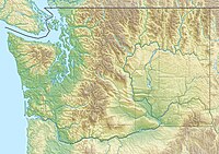
2019:
1176:
481:
Before Europeans came to inhabit and farm in the Horse Heaven Hills, the area had been occupied by
335:
316:
1666:
997:
2484:
2425:
1976:
J. ERIC SCHUSTER; CHARLES W. GULICK; STEPHEN P. REIDEL; KARL R. FECHT; STEPHANIE ZURENKO (1997).
1324:
1297:
753:
522:
494:
370:
203:
135:
2557:
2210:
1926:
764:
679:
621:
537:
514:
430:
409:
1566:
2572:
2502:
2305:
1770:
1367:
704:
652:
617:
562:
293:
211:
799:
operates the single largest wine making facility in the state of Washington in the town of
600:
577:
Heaven had a post office for about 30 years, while Bickleton's continues to operate today.
2552:
2535:
2413:
2232:
1909:
1692:
1387:
1309:
1119:
864:
633:
502:
486:
265:
257:
37:
2177:"State plan for irrigation project in Horse Heaven Hills leaves wheat farmers frustrated"
222:. The highest point is Bickleton Ridge in the west end of the hills. They lie within the
2335:
1874:"Science writer Richard Hill gives a brief geologic history of the Columbia River Gorge"
1766:
1518:
2700:
1836:
A Summary of Information on the Behavior of the Yakima Fold Belt as a Structural Entity
301:
43:
549:
2773:
2723:
2695:
2629:
2613:
2587:
2582:
2520:
2510:
1604:
849:
844:
The Horse Heaven Hills are dominated by grasses, shrubs, and small flowering plants.
629:
342:
309:
227:
1774:
1202:
308:
in the north. The Simcoe Mountains lead westward from the Horse Heaven Hills to the
2690:
2608:
2592:
700:
692:
688:
637:
566:
330:. Adjacent to the north side of the hills are much larger communities, such as the
305:
253:
1372:
1355:
745:, and various local governments hold small amounts of land throughout the range.
2245:
1923:
On the Trail of the Ice Age Floods: A Geological Guide to the Mid-Columbia Basin
1747:
907:
696:
668:
529:
421:
297:
230:, making them significantly drier and hotter than regions west of the Cascades.
223:
47:
288:
Looking eastbound on I-82 as it approaches the crest of the Horse Heaven Hills.
2685:
2453:
872:
857:
784:
749:
727:
644:
401:
385:
273:
2015:
1805:
Structure and Evolution of the Horse Heaven Hills in South-Central Washington
164:
151:
845:
812:
215:
207:
505:
societies. These peoples were removed from their ancestral homeland by the
2053:
341:
There are numerous county roads that traverse the range. It is crossed by
795:, was established in 2005 for the benefit of the wineries in the region.
660:
498:
1177:"Wet vs. Dry - Shedding some light on the Pacific Northwest rain shadow"
304:
in the east and south, and the anticline ridge that roughly follows the
2634:
1627:
1033:
U.S. Geological Survey Geographic Names Information System: Amon Canyon
875:
683:
656:
446:
384:
Several intermittent streams rise in the Horse Heaven Hills, including
300:. The range is bounded in the west by Satus Creek near Bickleton, the
868:
780:
586:
490:
425:
268:, which stand out from the basalt that dominates the Columbia Basin.
242:
73:
879:
831:
763:
675:
599:
590:
573:
548:
489:
tribe and served as the southern boundary of the territory of the
442:
395:
283:
1325:"Solving a mystery: Why Tri-City ozone levels rival Seattle area"
461:
The first contact these people had with Europeans was during the
1036:
187:
2457:
245:
have become an important economic driver in the region and the
1260:"Conserving Soil and Water in the World's Driest Wheat Region"
509:
in 1855. The Walla Walla and Umatilla peoples now live in the
369:
travels through the foothills of the range to connect I-82 to
2143:"100 Circle Farms: A McDonald's Potato Supplier | McDonald's"
2113:"Bill Gates is investing big in American farmland | Crosscut"
1356:"Tribal Distribution in Eastern Oregon and adjascant regions"
1007:. Washington State Legislature. April 25, 1985. p. 674.
933:
2361:
Fidorra, Jason (2018). 2018 Hunting Prospects - District 4.
2226:
Code of Federal Regulations. "§ 9.1888 Horse Heaven Hills."
1568:
Against Odds: A personal narrative of life in Horse Heaven
1120:"Dust Storm in Eastern Washington : Image of the Day"
783:
in the range, some of which grow a number of Washington's
485:
for centuries. The hills lied within the territory of the
659:
and then were deposited by the flood downstream when the
585:
Several million years ago, lava erupted from fissures in
424:
that makes nearly the entirety of eastern Washington and
541:
goes around the Horse Heaven Hills through Wallula Gap.
2246:"Washington 50-Meter Community-Scale Wind Resource Map"
1487:"The Volcanoes of Lewis and Clark - October 19, 1805"
1457:"The Columbia River - Horse Heaven Hills, Washington"
632:
approximately every 55 years. The discharge of this
445:
levels in the area to levels that are comparable to
2746:
2711:
2656:
2647:
2622:
2601:
2501:
2492:
2050:
Washington State Recreation and Conservation Office
141:
131:
123:
82:
72:
64:
59:
30:
1903:Lewis and Clark's Columbia River - Missoula Floods
1388:"Umatilla Relationships with US – Making Treaties"
1088:"About the EPA's work in the Columbia River Basin"
836:Native grasses in the Horse Heaven Hills south of
2170:
2168:
1987:Washington State Department of Natural Resources
735:Washington State Department of Natural Resources
691:scars. The loess contain erupted material from
404:over the Horse Heaven Hills and Columbia Basin.
292:The Horse Heaven Hills lead eastward from the
2469:
1979:GEOLOGIC MAP OF WASHINGTON SOUTHEAST QUADRANT
1005:Session Laws of the State of Washington, 1985
969:Washington State Department of Transportation
671:on the south side of the Horse Heaven Hills.
528:The Lewis and Clark Expedition came down the
264:. The floods contained icebergs that brought
8:
867:survey in Benton County identified numerous
998:"Chapter 177: State Highway Routes Revised"
2653:
2498:
2476:
2462:
2454:
2363:Washington Department of Fish and Wildlife
1571:. Concordia Publishing House. p. 29.
101:
27:
2795:Landforms of Klickitat County, Washington
2046:"Washington State Public Lands Inventory"
2016:"WA/OR - United States earthquakes, 1936"
1748:"The largest volcanic eruptions on Earth"
1371:
682:to the west considered to be part of the
1626:Gibson, Elizabeth (September 20, 2006).
472:
2438:from the original on September 28, 2020
2076:"Horse Heaven Hills Wilderness Charter"
1727:from the original on September 30, 2018
1691:. Tacoma Public Library. Archived from
1638:from the original on September 30, 2018
1499:from the original on September 30, 2018
1467:from the original on September 30, 2018
1156:from the original on September 28, 2018
1100:from the original on September 29, 2018
899:
2800:Landforms of Yakima County, Washington
2790:Landforms of Benton County, Washington
2187:from the original on September 6, 2022
2153:from the original on February 15, 2021
2123:from the original on February 11, 2021
2026:from the original on February 19, 2016
1575:from the original on September 6, 2022
1305:
1295:
1209:from the original on November 17, 2015
1183:from the original on November 12, 2020
934:"USGIS U.S. Board of Geographic Names"
2805:Mountain ranges of Washington (state)
2761:List of mountain ranges in Washington
2384:from the original on October 10, 2018
2342:from the original on October 10, 2018
2175:Prengaman, Kate (November 14, 2016).
2022:: Pacific Northwest Seismic Network.
1844:Pacific Northwest National Laboratory
1335:from the original on October 10, 2018
1014:from the original on January 27, 2017
940:from the original on February 4, 2012
678:and ash from volcanic eruptions from
429:Kennewick before construction of the
214:formed by north–south compression of
7:
2426:"MCBONES Research Center Foundation"
2316:from the original on October 9, 2018
2256:from the original on October 9, 2018
2092:from the original on August 11, 2017
1957:from the original on October 1, 2018
1816:from the original on October 1, 2018
1529:from the original on October 1, 2018
1437:from the original on August 12, 2017
1270:from the original on October 1, 2018
1130:from the original on October 9, 2009
914:from the original on August 13, 2018
593:creating what is known today as the
260:that occurred toward the end of the
2407:, vol. 43, no. 4, 1969, pp. 156–161
2378:"Horses and the Horse Heaven Hills"
1996:from the original on August 5, 2019
1784:from the original on August 7, 2020
1665:. The Seattle Times. Archived from
1519:"Legacy Washington - Benton County"
1205:. Western Regional Climate Center.
1058:United States Bureau of Reclamation
961:Washington State Highways 2014–2015
768:Farmland in the Horse Heaven Hills.
323:at the southwest end of the range.
50:; note the dark areas of extensive
2336:"Horse Heaven Hills (Benton City)"
1925:. Keokee Books; Sandpoint, Idaho.
1398:from the original on March 3, 2016
1240:from the original on March 4, 2018
1228:McShane, Dan (November 28, 2012).
824:(32.8 km) transmission line.
741:has significant holdings south of
604:Location of the former Lake Lewis.
517:, and the Yakamas now live on the
186:are a long range of high, rolling
16:Range of hills in Washington, U.S.
14:
2662:incl. Olympic Mountains foothills
2376:McShane, Dan (October 26, 2013).
1854:from the original on May 13, 2017
1689:"Washington Place Names database"
978:from the original on July 9, 2019
233:The region has been inhabited by
42:The Horse Heaven Hills along the
19:For the wine growing region, see
1234:Reading the Washington Landscape
1203:"BICKLETON, WASHINGTON (450456)"
1068:from the original on May 9, 2019
100:
93:
36:
1947:"The Land - Horse Heaven Hills"
1775:10.1016/j.earscirev.2010.07.001
1657:Seven, Richard (May 27, 2001).
1492:United States Geological Survey
1323:Cary, Annette (July 27, 2016).
1290:Climatological Data, Washington
1093:Environmental Protection Agency
908:"Rattlesnake Hills - Geography"
818:Bonneville Power Administration
373:, passing to the north side of
572:Farmers began growing dryland
561:James Gordon Kinney, an early
252:North-to-south compression of
1:
1628:"Prosser - Thumbnail History"
1523:Washington Secretary of State
1373:10.1525/aa.1938.40.3.02a00040
414:Köppen climate classification
2209:pg 85 Raconteurs Press 2002
2207:Discovering Washington Wines
1720:United States Postal Service
1659:"Bluebirds & Bloodlines"
1417:Lozar, Patrick (June 2013).
624:forming a large lake termed
412:. Throughout the range, the
78:4,327 ft (1,319 m)
2785:Hills of Washington (state)
1715:"Bickleton, WA Post Office"
595:Columbia River Basalt Group
532:to the present day site of
511:Umatilla Indian Reservation
220:Columbia River Basalt Group
2821:
2306:"Juniper Canyon Wind Farm"
2276:"Nine Canyon Wind Project"
2231:February 12, 2012, at the
1663:Pacific Northwest Magazine
1565:Sihler, Elizabeth (1917).
1179:. The Weather Prediction.
1050:"Yakima River Basin Study"
871:skeletal remains, proving
793:American Viticultural Area
712:1936 State Line earthquake
469:Prehistory and exploration
463:Lewis and Clark Expedition
239:Lewis and Clark Expedition
18:
2758:
2752:Olympic–Wallowa Lineament
2250:U.S. Department of Energy
2083:Bureau of Land Management
1921:Bjornstad, Bruce (2006).
1908:October 27, 2006, at the
1810:Portland State University
1152:. Washington State Wine.
739:Bureau of Land Management
519:Yakama Indian Reservation
249:was established in 2005.
87:
35:
1802:Hagood, Michael (1985).
716:Milton-Freewater, Oregon
361:, connecting Prosser to
1847:(Report). August 2012.
1595:"Benton County History"
1360:American Anthropologist
2412:June 10, 2011, at the
2181:Yakima Herald-Republic
1551:Yakima Herald-Republic
1354:Ray, Verne F. (1938).
1264:Certified Crop Adviser
1124:NASA Earth Observatory
856:end of the range near
841:
789:Horse Heaven Hills AVA
769:
651:. The flood deposited
608:Toward the end of the
605:
554:
478:
405:
289:
247:Horse Heaven Hills AVA
114:Location in Washington
21:Horse Heaven Hills AVA
1755:Earth-Science Reviews
1607:on September 27, 2007
1461:Columbia River Images
1175:Christiansen, Corey.
835:
820:transmission system.
797:Chateau Ste. Michelle
767:
626:Glacial Lake Missoula
614:Cordilleran Ice Sheet
603:
553:A shed near Bickleton
552:
476:
399:
287:
2658:Pacific Coast Ranges
2563:Rattlesnake Mountain
2431:. January 29, 2013.
2111:Weinberger, Hannah.
2085:. October 24, 2018.
1695:on September 5, 2012
1428:University of Oregon
1150:"Horse Heaven Hills"
1096:. January 22, 2013.
665:Columbia River Gorge
610:last glacial maximum
534:Sacajawea State Park
206:. The hills are an
165:46.133°N 119.86750°W
2020:Seattle, Washington
1767:2010ESRv..102..207B
1392:www.trailtribes.org
1230:"Zintel Canyon Dam"
1126:. October 6, 2009.
779:There are numerous
754:Cascade Investments
507:Walla Walla Council
317:Yakima River Valley
226:to the east of the
161: /
54:exposed by erosion.
2780:Horse Heaven Hills
2541:Horse Heaven Hills
2338:. April 18, 2010.
2286:on October 9, 2018
2056:on October 2, 2018
1985:(Map). 1:250,000.
842:
770:
606:
555:
523:Yakima, Washington
501:language and were
479:
458:American peoples.
406:
349:), which connects
290:
184:Horse Heaven Hills
170:46.133; -119.86750
108:Horse Heaven Hills
60:Highest point
31:Horse Heaven Hills
2767:
2766:
2742:
2741:
2703:
2681:
2663:
2643:
2642:
2558:Rattlesnake Hills
2548:
2405:Northwest Science
2147:www.mcdonalds.com
1932:978-1-879628-27-4
1884:on August 4, 2008
1061:. February 2011.
680:Cascade volcanoes
622:Missoula, Montana
515:Pendleton, Oregon
431:Zintel Canyon Dam
180:
179:
143:Range coordinates
2812:
2699:
2673:
2661:
2654:
2573:Saddle Mountains
2544:
2503:Yakima Fold Belt
2499:
2487:hills and ridges
2478:
2471:
2464:
2455:
2448:
2447:
2445:
2443:
2437:
2430:
2422:
2416:
2400:
2394:
2393:
2391:
2389:
2373:
2367:
2366:
2358:
2352:
2351:
2349:
2347:
2332:
2326:
2325:
2323:
2321:
2310:Power Technology
2302:
2296:
2295:
2293:
2291:
2282:. Archived from
2280:Energy Northwest
2272:
2266:
2265:
2263:
2261:
2242:
2236:
2223:
2217:
2203:
2197:
2196:
2194:
2192:
2172:
2163:
2162:
2160:
2158:
2139:
2133:
2132:
2130:
2128:
2108:
2102:
2101:
2099:
2097:
2091:
2080:
2072:
2066:
2065:
2063:
2061:
2052:. Archived from
2042:
2036:
2035:
2033:
2031:
2012:
2006:
2005:
2003:
2001:
1995:
1984:
1973:
1967:
1966:
1964:
1962:
1943:
1937:
1936:
1918:
1912:
1900:
1894:
1893:
1891:
1889:
1880:. Archived from
1870:
1864:
1863:
1861:
1859:
1853:
1840:
1832:
1826:
1825:
1823:
1821:
1799:
1793:
1792:
1791:
1789:
1783:
1761:(3–4): 207–229,
1752:
1743:
1737:
1736:
1734:
1732:
1711:
1705:
1704:
1702:
1700:
1685:
1679:
1678:
1676:
1674:
1654:
1648:
1647:
1645:
1643:
1623:
1617:
1616:
1614:
1612:
1603:. Archived from
1591:
1585:
1584:
1582:
1580:
1562:
1556:
1555:
1545:
1539:
1538:
1536:
1534:
1515:
1509:
1508:
1506:
1504:
1483:
1477:
1476:
1474:
1472:
1453:
1447:
1446:
1444:
1442:
1436:
1425:
1414:
1408:
1407:
1405:
1403:
1384:
1378:
1377:
1375:
1351:
1345:
1344:
1342:
1340:
1320:
1314:
1313:
1307:
1303:
1301:
1293:
1286:
1280:
1279:
1277:
1275:
1256:
1250:
1249:
1247:
1245:
1225:
1219:
1218:
1216:
1214:
1199:
1193:
1192:
1190:
1188:
1172:
1166:
1165:
1163:
1161:
1146:
1140:
1139:
1137:
1135:
1116:
1110:
1109:
1107:
1105:
1084:
1078:
1077:
1075:
1073:
1067:
1054:
1046:
1040:
1030:
1024:
1023:
1021:
1019:
1013:
1002:
994:
988:
987:
985:
983:
977:
966:
956:
950:
949:
947:
945:
930:
924:
923:
921:
919:
904:
752:' asset manager
705:Mount St. Helens
653:glacial erratics
612:, a lobe of the
483:Native Americans
294:Simcoe Mountains
266:glacial erratics
235:Native Americans
212:Yakima Fold Belt
176:
175:
173:
172:
171:
166:
162:
159:
158:
157:
154:
104:
103:
97:
40:
28:
2820:
2819:
2815:
2814:
2813:
2811:
2810:
2809:
2770:
2769:
2768:
2763:
2754:
2738:
2707:
2660:
2649:
2639:
2618:
2597:
2578:Snipes Mountain
2553:Manastash Ridge
2536:Frenchman Hills
2516:Badger Mountain
2494:
2488:
2482:
2452:
2451:
2441:
2439:
2435:
2428:
2424:
2423:
2419:
2414:Wayback Machine
2401:
2397:
2387:
2385:
2375:
2374:
2370:
2360:
2359:
2355:
2345:
2343:
2334:
2333:
2329:
2319:
2317:
2304:
2303:
2299:
2289:
2287:
2274:
2273:
2269:
2259:
2257:
2244:
2243:
2239:
2233:Wayback Machine
2224:
2220:
2204:
2200:
2190:
2188:
2174:
2173:
2166:
2156:
2154:
2141:
2140:
2136:
2126:
2124:
2110:
2109:
2105:
2095:
2093:
2089:
2078:
2074:
2073:
2069:
2059:
2057:
2044:
2043:
2039:
2029:
2027:
2014:
2013:
2009:
1999:
1997:
1993:
1982:
1975:
1974:
1970:
1960:
1958:
1945:
1944:
1940:
1933:
1920:
1919:
1915:
1910:Wayback Machine
1901:
1897:
1887:
1885:
1872:
1871:
1867:
1857:
1855:
1851:
1838:
1834:
1833:
1829:
1819:
1817:
1801:
1800:
1796:
1787:
1785:
1781:
1750:
1745:
1744:
1740:
1730:
1728:
1713:
1712:
1708:
1698:
1696:
1687:
1686:
1682:
1672:
1670:
1669:on June 8, 2001
1656:
1655:
1651:
1641:
1639:
1625:
1624:
1620:
1610:
1608:
1593:
1592:
1588:
1578:
1576:
1564:
1563:
1559:
1547:
1546:
1542:
1532:
1530:
1517:
1516:
1512:
1502:
1500:
1485:
1484:
1480:
1470:
1468:
1455:
1454:
1450:
1440:
1438:
1434:
1423:
1416:
1415:
1411:
1401:
1399:
1386:
1385:
1381:
1353:
1352:
1348:
1338:
1336:
1329:Tri-City Herald
1322:
1321:
1317:
1304:
1294:
1288:
1287:
1283:
1273:
1271:
1258:
1257:
1253:
1243:
1241:
1227:
1226:
1222:
1212:
1210:
1201:
1200:
1196:
1186:
1184:
1174:
1173:
1169:
1159:
1157:
1148:
1147:
1143:
1133:
1131:
1118:
1117:
1113:
1103:
1101:
1086:
1085:
1081:
1071:
1069:
1065:
1052:
1048:
1047:
1043:
1031:
1027:
1017:
1015:
1011:
1000:
996:
995:
991:
981:
979:
975:
964:
958:
957:
953:
943:
941:
932:
931:
927:
917:
915:
906:
905:
901:
896:
865:paleontological
830:
809:
762:
724:
583:
547:
503:hunter-gatherer
471:
455:
394:
367:State Route 397
359:State Route 221
345:(cosigned with
282:
169:
167:
163:
160:
155:
152:
150:
148:
147:
119:
118:
117:
116:
115:
112:
111:
110:
109:
105:
68:Bickleton Ridge
55:
24:
17:
12:
11:
5:
2818:
2816:
2808:
2807:
2802:
2797:
2792:
2787:
2782:
2772:
2771:
2765:
2764:
2759:
2756:
2755:
2750:
2748:
2744:
2743:
2740:
2739:
2737:
2736:
2731:
2726:
2721:
2715:
2713:
2709:
2708:
2706:
2705:
2701:Boistfort Peak
2693:
2688:
2683:
2679:Larch Mountain
2666:
2664:
2651:
2645:
2644:
2641:
2640:
2638:
2637:
2632:
2626:
2624:
2620:
2619:
2617:
2616:
2611:
2605:
2603:
2599:
2598:
2596:
2595:
2590:
2585:
2580:
2575:
2570:
2565:
2560:
2555:
2550:
2538:
2533:
2531:Columbia Hills
2528:
2526:Candy Mountain
2523:
2518:
2513:
2507:
2505:
2496:
2490:
2489:
2483:
2481:
2480:
2473:
2466:
2458:
2450:
2449:
2417:
2395:
2368:
2353:
2327:
2297:
2267:
2237:
2218:
2198:
2164:
2134:
2103:
2067:
2037:
2007:
1968:
1938:
1931:
1913:
1895:
1865:
1827:
1794:
1738:
1706:
1680:
1649:
1618:
1586:
1557:
1540:
1510:
1478:
1448:
1409:
1379:
1366:(3): 385–386.
1346:
1315:
1281:
1251:
1220:
1194:
1167:
1141:
1111:
1079:
1041:
1025:
989:
951:
925:
898:
897:
895:
892:
829:
826:
808:
805:
761:
758:
723:
720:
582:
579:
546:
543:
470:
467:
454:
451:
393:
390:
379:State Route 14
302:Columbia River
281:
278:
258:massive floods
178:
177:
145:
139:
138:
133:
129:
128:
125:
121:
120:
113:
107:
106:
99:
98:
92:
91:
90:
89:
88:
85:
84:
80:
79:
76:
70:
69:
66:
62:
61:
57:
56:
44:Columbia River
41:
33:
32:
15:
13:
10:
9:
6:
4:
3:
2:
2817:
2806:
2803:
2801:
2798:
2796:
2793:
2791:
2788:
2786:
2783:
2781:
2778:
2777:
2775:
2762:
2757:
2753:
2749:
2745:
2735:
2734:Puget Lowland
2732:
2730:
2729:Kitsap County
2727:
2725:
2724:Issaquah Alps
2722:
2720:
2717:
2716:
2714:
2710:
2702:
2697:
2696:Willapa Hills
2694:
2692:
2689:
2687:
2684:
2680:
2676:
2671:
2668:
2667:
2665:
2659:
2655:
2652:
2646:
2636:
2635:Palouse Hills
2633:
2631:
2630:Dishman Hills
2628:
2627:
2625:
2621:
2615:
2614:Steptoe Butte
2612:
2610:
2607:
2606:
2604:
2600:
2594:
2591:
2589:
2588:Wahluke Slope
2586:
2584:
2583:Umtanum Ridge
2581:
2579:
2576:
2574:
2571:
2569:
2566:
2564:
2561:
2559:
2556:
2554:
2551:
2547:
2542:
2539:
2537:
2534:
2532:
2529:
2527:
2524:
2522:
2521:Beezley Hills
2519:
2517:
2514:
2512:
2511:Ahtanum Ridge
2509:
2508:
2506:
2504:
2500:
2497:
2491:
2486:
2479:
2474:
2472:
2467:
2465:
2460:
2459:
2456:
2434:
2427:
2421:
2418:
2415:
2411:
2408:
2406:
2399:
2396:
2383:
2379:
2372:
2369:
2364:
2357:
2354:
2341:
2337:
2331:
2328:
2315:
2311:
2307:
2301:
2298:
2285:
2281:
2277:
2271:
2268:
2255:
2252:. June 2002.
2251:
2247:
2241:
2238:
2234:
2230:
2227:
2222:
2219:
2216:
2215:0-9719258-5-2
2212:
2208:
2202:
2199:
2186:
2182:
2178:
2171:
2169:
2165:
2152:
2148:
2144:
2138:
2135:
2122:
2118:
2114:
2107:
2104:
2088:
2084:
2077:
2071:
2068:
2055:
2051:
2047:
2041:
2038:
2025:
2021:
2017:
2011:
2008:
1992:
1988:
1981:
1980:
1972:
1969:
1961:September 30,
1956:
1952:
1951:Double Canyon
1948:
1942:
1939:
1934:
1928:
1924:
1917:
1914:
1911:
1907:
1904:
1899:
1896:
1883:
1879:
1878:The Oregonian
1875:
1869:
1866:
1858:September 30,
1850:
1846:
1845:
1837:
1831:
1828:
1820:September 30,
1815:
1811:
1807:
1806:
1798:
1795:
1780:
1776:
1772:
1768:
1764:
1760:
1756:
1749:
1742:
1739:
1731:September 30,
1726:
1722:
1721:
1716:
1710:
1707:
1694:
1690:
1684:
1681:
1673:September 15,
1668:
1664:
1660:
1653:
1650:
1642:September 29,
1637:
1633:
1629:
1622:
1619:
1611:September 29,
1606:
1602:
1601:
1600:Benton County
1596:
1590:
1587:
1574:
1570:
1569:
1561:
1558:
1553:
1552:
1544:
1541:
1533:September 30,
1528:
1524:
1520:
1514:
1511:
1503:September 29,
1498:
1494:
1493:
1488:
1482:
1479:
1471:September 29,
1466:
1462:
1458:
1452:
1449:
1441:September 29,
1433:
1429:
1422:
1421:
1413:
1410:
1397:
1393:
1389:
1383:
1380:
1374:
1369:
1365:
1361:
1357:
1350:
1347:
1334:
1330:
1326:
1319:
1316:
1311:
1299:
1291:
1285:
1282:
1274:September 30,
1269:
1265:
1261:
1255:
1252:
1239:
1235:
1231:
1224:
1221:
1208:
1204:
1198:
1195:
1187:September 27,
1182:
1178:
1171:
1168:
1160:September 27,
1155:
1151:
1145:
1142:
1129:
1125:
1121:
1115:
1112:
1104:September 28,
1099:
1095:
1094:
1089:
1083:
1080:
1072:September 28,
1064:
1060:
1059:
1051:
1045:
1042:
1038:
1034:
1029:
1026:
1018:September 19,
1010:
1006:
999:
993:
990:
982:September 27,
974:
970:
963:
962:
955:
952:
939:
935:
929:
926:
918:September 27,
913:
909:
903:
900:
893:
891:
889:
885:
881:
877:
874:
870:
866:
861:
859:
853:
851:
850:cushion daisy
847:
839:
834:
827:
825:
821:
819:
814:
806:
804:
802:
798:
794:
790:
786:
782:
777:
774:
766:
759:
757:
755:
751:
746:
744:
740:
736:
731:
729:
721:
719:
717:
713:
708:
706:
702:
698:
694:
690:
685:
681:
677:
672:
670:
666:
662:
658:
654:
650:
646:
641:
639:
635:
634:massive flood
631:
630:Pacific Ocean
627:
623:
619:
615:
611:
602:
598:
596:
592:
588:
580:
578:
575:
570:
568:
564:
559:
551:
544:
542:
539:
535:
531:
526:
524:
520:
516:
512:
508:
504:
500:
496:
492:
488:
484:
475:
468:
466:
464:
459:
452:
450:
448:
444:
438:
434:
432:
427:
423:
417:
415:
411:
403:
398:
391:
389:
387:
382:
380:
376:
372:
368:
364:
360:
356:
352:
348:
344:
343:Interstate 82
339:
337:
333:
329:
324:
322:
318:
313:
311:
310:Cascade Range
307:
303:
299:
295:
286:
279:
277:
275:
269:
267:
263:
259:
255:
254:flood basalts
250:
248:
244:
240:
236:
231:
229:
228:Cascade Range
225:
221:
217:
213:
210:ridge in the
209:
205:
201:
197:
193:
189:
185:
174:
146:
144:
140:
137:
134:
130:
127:United States
126:
122:
96:
86:
81:
77:
75:
71:
67:
63:
58:
53:
52:flood basalts
49:
45:
39:
34:
29:
26:
22:
2691:Satsop Hills
2675:Capitol Peak
2609:Kamiak Butte
2593:Yakima Ridge
2568:Red Mountain
2546:Jump Off Joe
2540:
2440:. Retrieved
2420:
2404:
2398:
2386:. Retrieved
2371:
2362:
2356:
2344:. Retrieved
2330:
2318:. Retrieved
2309:
2300:
2288:. Retrieved
2284:the original
2279:
2270:
2258:. Retrieved
2249:
2240:
2221:
2206:
2201:
2189:. Retrieved
2180:
2157:February 11,
2155:. Retrieved
2146:
2137:
2127:February 11,
2125:. Retrieved
2117:crosscut.com
2116:
2106:
2094:. Retrieved
2082:
2070:
2058:. Retrieved
2054:the original
2049:
2040:
2030:February 26,
2028:. Retrieved
2010:
1998:. Retrieved
1978:
1971:
1959:. Retrieved
1950:
1941:
1922:
1916:
1898:
1886:. Retrieved
1882:the original
1877:
1868:
1856:. Retrieved
1842:
1830:
1818:. Retrieved
1804:
1797:
1786:, retrieved
1758:
1754:
1741:
1729:. Retrieved
1718:
1709:
1697:. Retrieved
1693:the original
1683:
1671:. Retrieved
1667:the original
1662:
1652:
1640:. Retrieved
1632:History Link
1631:
1621:
1609:. Retrieved
1605:the original
1598:
1589:
1577:. Retrieved
1567:
1560:
1549:
1543:
1531:. Retrieved
1522:
1513:
1501:. Retrieved
1490:
1481:
1469:. Retrieved
1460:
1451:
1439:. Retrieved
1419:
1412:
1402:December 14,
1400:. Retrieved
1391:
1382:
1363:
1359:
1349:
1337:. Retrieved
1328:
1318:
1289:
1284:
1272:. Retrieved
1263:
1254:
1242:. Retrieved
1233:
1223:
1213:November 16,
1211:. Retrieved
1197:
1185:. Retrieved
1170:
1158:. Retrieved
1144:
1132:. Retrieved
1114:
1102:. Retrieved
1091:
1082:
1070:. Retrieved
1056:
1044:
1028:
1016:. Retrieved
1004:
992:
980:. Retrieved
960:
954:
942:. Retrieved
928:
916:. Retrieved
902:
888:last Ice Age
884:early horses
862:
854:
843:
822:
810:
778:
775:
771:
747:
732:
725:
709:
701:Glacier Peak
693:Mount Mazama
689:mass wasting
673:
642:
638:Amazon River
607:
584:
571:
567:feral horses
560:
556:
527:
480:
460:
456:
439:
435:
418:
407:
383:
375:Jump Off Joe
340:
328:Horse Heaven
325:
314:
306:Yakima River
291:
270:
262:last ice age
251:
232:
202:counties in
183:
181:
25:
2670:Black Hills
2442:October 10,
1699:October 30,
1306:|work=
1244:February 2,
1134:October 10,
944:October 12,
873:prehistoric
838:Benton City
760:Agriculture
743:Benton City
697:Crater Lake
669:Lake Condon
616:dammed the
530:Snake River
495:Walla Walla
493:tribe. The
422:rain shadow
298:Wallula Gap
224:rain shadow
168: /
156:119°52.05′W
48:Wallula Gap
2774:Categories
2719:Blue Hills
2686:Doty Hills
2650:Washington
2495:Washington
2485:Washington
2388:October 9,
2346:October 9,
2320:October 8,
2290:October 8,
2260:October 8,
2205:T. Parker
2191:October 8,
2096:October 8,
2060:October 8,
1808:(Thesis).
1579:October 1,
1426:(Thesis).
1339:October 9,
894:References
869:fossilized
858:Satus Pass
813:wind farms
785:cult wines
750:Bill Gates
728:Irrigation
649:Moses Lake
645:Lake Lewis
618:Clark Fork
545:Settlement
402:dust storm
386:Amon Creek
332:Tri-Cities
274:Satus Pass
216:lava flows
204:Washington
136:Washington
2365:(Report).
2000:August 4,
1308:ignored (
1298:cite book
846:Sagebrush
748:In 2018,
722:Human use
521:south of
433:in 1992.
410:Hermiston
351:Kennewick
321:Bickleton
280:Geography
208:anticline
192:Klickitat
83:Geography
74:Elevation
2602:Steptoes
2433:Archived
2410:Archived
2382:Archived
2340:Archived
2314:Archived
2254:Archived
2229:Archived
2185:Archived
2151:Archived
2121:Archived
2087:Archived
2024:Archived
1991:Archived
1955:Archived
1906:Archived
1888:June 15,
1849:Archived
1814:Archived
1779:archived
1725:Archived
1636:Archived
1573:Archived
1527:Archived
1497:Archived
1465:Archived
1432:Archived
1396:Archived
1333:Archived
1268:Archived
1238:Archived
1207:Archived
1181:Archived
1154:Archived
1128:Archived
1098:Archived
1063:Archived
1009:Archived
973:Archived
971:. 2014.
938:Archived
912:Archived
876:mammoths
863:A small
801:Paterson
781:wineries
667:forming
661:icebergs
499:Sahaptin
487:Umatilla
363:Paterson
355:Plymouth
243:wineries
2747:Related
2648:Western
2493:Eastern
1788:June 7,
1763:Bibcode
1292:. 1969.
967:(Map).
828:Ecology
684:Palouse
657:Alberta
581:Geology
563:pioneer
453:History
447:Seattle
392:Climate
336:Prosser
218:in the
153:46°08′N
124:Country
2213:
1929:
880:bisons
807:Energy
787:. The
737:. The
703:, and
587:Oregon
491:Yakama
426:Oregon
371:Finley
357:, and
347:US 395
200:Benton
198:, and
196:Yakima
2712:Other
2623:Other
2436:(PDF)
2429:(PDF)
2090:(PDF)
2079:(PDF)
1994:(PDF)
1983:(PDF)
1852:(PDF)
1839:(PDF)
1782:(PDF)
1751:(PDF)
1435:(PDF)
1424:(PDF)
1066:(PDF)
1053:(PDF)
1039:GNIS.
1012:(PDF)
1001:(PDF)
976:(PDF)
965:(PDF)
791:, an
714:near
676:loess
620:near
591:Idaho
574:wheat
538:Pasco
536:near
513:near
443:ozone
188:hills
132:State
2444:2018
2390:2018
2348:2018
2322:2018
2292:2018
2262:2018
2211:ISBN
2193:2018
2159:2021
2129:2021
2098:2018
2062:2018
2032:2018
2002:2019
1963:2018
1927:ISBN
1890:2008
1860:2018
1822:2018
1790:2020
1733:2018
1701:2012
1675:2018
1644:2018
1613:2018
1581:2018
1535:2018
1505:2018
1473:2018
1443:2018
1404:2015
1341:2018
1310:help
1276:2018
1246:2018
1215:2015
1189:2018
1162:2018
1136:2009
1106:2018
1074:2018
1037:USGS
1020:2018
984:2018
946:2009
920:2018
710:The
589:and
334:and
182:The
65:Peak
1771:doi
1759:102
1368:doi
699:),
353:to
296:to
190:in
46:at
2776::
2677:,
2380:.
2312:.
2308:.
2278:.
2248:.
2183:.
2179:.
2167:^
2149:.
2145:.
2119:.
2115:.
2081:.
2048:.
2018:.
1989:.
1953:.
1949:.
1876:.
1841:.
1812:.
1777:,
1769:,
1757:,
1753:,
1723:.
1717:.
1661:.
1634:.
1630:.
1597:.
1525:.
1521:.
1495:.
1489:.
1463:.
1459:.
1430:.
1394:.
1390:.
1364:40
1362:.
1358:.
1331:.
1327:.
1302::
1300:}}
1296:{{
1266:.
1262:.
1236:.
1232:.
1122:.
1090:.
1055:.
1035:,
1003:.
936:.
910:.
882:,
878:,
803:.
707:.
640:.
525:.
400:A
377:.
365:.
338:.
312:.
194:,
2704:)
2698:(
2682:)
2672:(
2549:)
2543:(
2477:e
2470:t
2463:v
2446:.
2392:.
2350:.
2324:.
2294:.
2264:.
2195:.
2161:.
2131:.
2100:.
2064:.
2034:.
2004:.
1965:.
1935:.
1892:.
1862:.
1824:.
1773::
1765::
1735:.
1703:.
1677:.
1646:.
1615:.
1583:.
1554:.
1537:.
1507:.
1475:.
1445:.
1406:.
1376:.
1370::
1343:.
1312:)
1278:.
1248:.
1217:.
1191:.
1164:.
1138:.
1108:.
1076:.
1022:.
986:.
948:.
922:.
840:.
695:(
23:.
Text is available under the Creative Commons Attribution-ShareAlike License. Additional terms may apply.