Horseshoe Lake State Park
Source 📝
1542:
62:
98:
45:
1483:
105:
69:
1516:
644:
509:
240:'s Schoolhouse Trail, which connects to over 85 miles (137 km) of bike trail in Madison County, and even a trail which goes all of the way to downtown St. Louis after crossing the
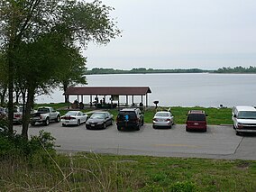
236:. Horseshoe Lake is the second largest natural lake in Illinois taking up approximately 2,400 acres (971 ha) of the 2,960-acre (1,198 ha) park. The park has connections to
349:
623:
1612:
1227:
393:
1583:
494:
1360:
1217:
1202:
1137:
587:
1177:
1390:
1297:
1167:
1147:
1122:
309:
1307:
1292:
1187:
1157:
484:
1312:
1272:
1267:
1242:
1232:
1152:
1097:
61:
1317:
1262:
1182:
1172:
1117:
1112:
1107:
1102:
615:
342:
233:
1508:
1302:
1287:
1222:
1212:
1207:
1007:
285:
266:
201:
97:
1247:
1237:
1077:
1067:
1062:
1057:
919:
851:
559:
459:
403:
366:
1576:
1282:
1257:
1252:
711:
597:
549:
454:
388:
375:
158:
1375:
1355:
1350:
1322:
1277:
1192:
1132:
1047:
1017:
1002:
479:
449:
781:
1520:
1487:
1197:
1052:
499:
469:
335:
1622:
1464:
1456:
1415:
1365:
1332:
1162:
1087:
972:
911:
668:
504:
474:
444:
398:
358:
281:
1127:
1032:
1022:
997:
992:
982:
527:
489:
1569:
1345:
1042:
987:
761:
701:
380:
1607:
1400:
1380:
816:
691:
628:
464:
408:
1142:
418:
1340:
1012:
934:
896:
30:
1037:
886:
676:
1447:
1395:
1370:
826:
213:
1405:
962:
947:
796:
605:
554:
1602:
1541:
952:
786:
731:
1072:
861:
836:
791:
776:
638:
579:
1549:
881:
856:
821:
801:
751:
726:
436:
217:
128:
1433:
957:
876:
871:
736:
706:
696:
426:
1494:
942:
866:
811:
686:
681:
659:
633:
541:
537:
249:
237:
146:
901:
891:
756:
245:
841:
746:
716:
289:
1617:
846:
1501:
1385:
1027:
721:
519:
262:
831:
806:
771:
241:
1553:
229:
34:
44:
1428:
569:
1596:
225:
136:
1423:
564:
741:
327:
77:
173:
160:
313:
221:
132:
81:
228:. It is approximately 2,960 acres (1,198 ha) and surrounds a large
923:
305:
331:
252:, 10-mile (16 km) northeast of downtown St. Louis.
1557:
310:"Horseshoe Lake State Park, USGS Monks Mound (IL) Quad"
1455:
1446:
1414:
1331:
1086:
971:
933:
910:
667:
658:
614:
596:
578:
536:
518:
435:
417:
374:
365:
197:
189:
152:
142:
124:
23:
104:
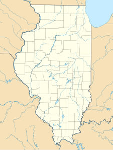
84:showing the location of Horseshoe Lake State Park
68:
588:List of National Natural Landmarks in Illinois
1577:
343:
112:Horseshoe Lake State Park (the United States)
8:
1613:Protected areas of Madison County, Illinois
1584:
1570:
1452:
664:
371:
350:
336:
328:
20:
1509:Illinois Department of Natural Resources
286:Illinois Department of Natural Resources
267:Illinois Department of Natural Resources
202:Illinois Department of Natural Resources
1465:Local forest and conservation districts
550:Abraham Lincoln National Heritage Area
248:. The park is located in southeastern
16:State park in Madison County, Illinois
920:List of Illinois State Historic Sites
7:
1538:
1536:
1515:
616:Wetlands of international importance
123:
639:Chiwaukee Illinois Beach Lake Plain
49:Horseshoe Lake State Park, May 2009
1556:. You can help Knowledge (XXG) by
528:Midewin National Tallgrass Prairie
263:"Horseshoe Lake State Park (IDNR)"
14:
1158:Horseshoe Lake (Alexander County)
394:Emmett Till and Mamie Till-Mobley
376:National Historic Sites and Parks
1540:
1514:
1482:
1481:
103:
96:
67:
60:
43:
598:National Wild and Scenic Rivers
141:
1:
115:Show map of the United States
606:Middle Fork Vermilion River
555:Illinois and Michigan Canal
359:Protected areas of Illinois
282:"Horseshoe Lake State Park"
193:2,960 acres (1,198 ha)
35:natural monument or feature
1639:
1623:Metro-East geography stubs
1535:
580:National Natural Landmarks
1477:
624:Cache River-Cypress Creek
437:National Wildlife Refuges
210:Horseshoe Lake State Park
54:
42:
28:
24:Horseshoe Lake State Park
1550:Madison County, Illinois
495:Middle Mississippi River
1608:State parks of Illinois
1228:Jim Edgar Panther Creek
641:(shared with Wisconsin)
510:Upper Mississippi River
1552:location article is a
1391:Sand Prairie-Scrub Oak
762:Hennepin Canal Parkway
634:Dixon Waterfowl Refuge
542:National Heritage Area
250:Granite City, Illinois
238:Madison County Transit
147:Granite City, Illinois
1361:Harry "Babe" Woodyard
817:Mississippi Palisades
246:Chain of Rocks Bridge
174:38.68556°N 90.09417°W
926:World Heritage Site)
912:State Historic Sites
87:Show map of Illinois
1333:State Natural Areas
897:William G. Stratton
782:James "Pate" Philip
629:The Emiquon Complex
214:Illinois state park
198:Governing body
179:38.68556; -90.09417
170: /
1386:Revis Hill Prairie
1376:Piney Creek Ravine
1356:Goose Lake Prairie
1351:Fults Hill Prairie
1028:North Point Marina
1008:Johnson-Sauk Trail
887:White Pines Forest
520:National Grassland
1603:IUCN Category III
1565:
1564:
1530:
1529:
1473:
1472:
1442:
1441:
1218:Mississippi River
1203:Mazonia/Braidwood
1138:Edward R. Madigan
1078:William W. Powers
1068:Wayne Fitzgerrell
1063:Washington County
1058:Stephen A. Forbes
852:Rock Island Trail
827:Morrison-Rockwood
654:
653:
645:Upper Mississippi
381:national monument
242:Mississippi River
207:
206:
143:Nearest city
1630:
1586:
1579:
1572:
1544:
1537:
1518:
1517:
1485:
1484:
1457:County Districts
1453:
1366:Illinois Caverns
1178:Kishwaukee River
975:Recreation Areas
892:Wildlife Prairie
797:Lake Murphysboro
665:
404:New Philadelphia
372:
352:
345:
338:
329:
324:
322:
320:
301:
299:
297:
292:on April 2, 2007
288:. Archived from
277:
275:
273:
230:horseshoe-shaped
185:
184:
182:
181:
180:
175:
171:
168:
167:
166:
163:
116:
107:
106:
100:
88:
71:
70:
64:
47:
21:
1638:
1637:
1633:
1632:
1631:
1629:
1628:
1627:
1593:
1592:
1591:
1590:
1533:
1531:
1526:
1469:
1438:
1410:
1396:Sielbeck Forest
1327:
1298:Snakeden Hollow
1168:Kaskaskia River
1163:Iroquois County
1148:Hamilton County
1123:Crawford County
1089:
1082:
1048:Randolph County
1018:Lake Le-Aqua-Na
1003:Golconda Marina
974:
967:
929:
906:
787:Jubilee College
732:Donnelley/Depue
650:
610:
592:
574:
560:Lewis and Clark
538:National Trails
532:
514:
431:
419:National Forest
413:
389:Chicago Portage
378:
361:
356:
318:
316:
304:
295:
293:
280:
271:
269:
261:
258:
178:
176:
172:
169:
164:
161:
159:
157:
156:
120:
119:
118:
117:
114:
113:
110:
109:
108:
91:
90:
89:
86:
85:
74:
73:
72:
50:
38:
17:
12:
11:
5:
1636:
1634:
1626:
1625:
1620:
1615:
1610:
1605:
1595:
1594:
1589:
1588:
1581:
1574:
1566:
1563:
1562:
1545:
1528:
1527:
1525:
1524:
1512:
1505:
1502:East St. Louis
1498:
1491:
1478:
1475:
1474:
1471:
1470:
1468:
1467:
1461:
1459:
1450:
1444:
1443:
1440:
1439:
1437:
1436:
1431:
1429:Trail of Tears
1426:
1420:
1418:
1412:
1411:
1409:
1408:
1403:
1398:
1393:
1388:
1383:
1378:
1373:
1368:
1363:
1358:
1353:
1348:
1346:Franklin Creek
1343:
1337:
1335:
1329:
1328:
1326:
1325:
1320:
1315:
1310:
1308:Ten Mile Creek
1305:
1300:
1295:
1293:Silver Springs
1290:
1285:
1280:
1275:
1270:
1265:
1260:
1255:
1250:
1245:
1240:
1235:
1230:
1225:
1220:
1215:
1210:
1205:
1200:
1195:
1190:
1188:Mackinaw River
1185:
1180:
1175:
1170:
1165:
1160:
1155:
1150:
1145:
1140:
1135:
1130:
1125:
1120:
1115:
1110:
1105:
1100:
1094:
1092:
1090:Wildlife Areas
1088:State Fish and
1084:
1083:
1081:
1080:
1075:
1073:Weldon Springs
1070:
1065:
1060:
1055:
1053:Sangchris Lake
1050:
1045:
1040:
1035:
1030:
1025:
1020:
1015:
1010:
1005:
1000:
995:
990:
985:
979:
977:
969:
968:
966:
965:
963:Trail of Tears
960:
955:
950:
948:Hidden Springs
945:
939:
937:
931:
930:
928:
927:
916:
914:
908:
907:
905:
904:
899:
894:
889:
884:
879:
874:
869:
864:
862:Siloam Springs
859:
854:
849:
844:
839:
837:Pere Marquette
834:
829:
824:
819:
814:
809:
804:
799:
794:
792:Kankakee River
789:
784:
779:
777:Illinois Beach
774:
769:
767:Horseshoe Lake
764:
759:
754:
749:
744:
739:
734:
729:
724:
719:
714:
709:
704:
699:
694:
689:
684:
679:
673:
671:
662:
656:
655:
652:
651:
649:
648:
642:
636:
631:
626:
620:
618:
612:
611:
609:
608:
602:
600:
594:
593:
591:
590:
584:
582:
576:
575:
573:
572:
570:Trail of Tears
567:
565:Mormon Pioneer
562:
557:
552:
546:
544:
534:
533:
531:
530:
524:
522:
516:
515:
513:
512:
507:
502:
497:
492:
487:
482:
477:
472:
467:
462:
460:Driftless Area
457:
452:
447:
441:
439:
433:
432:
430:
429:
423:
421:
415:
414:
412:
411:
406:
401:
396:
391:
385:
383:
369:
363:
362:
357:
355:
354:
347:
340:
332:
326:
325:
302:
278:
257:
254:
234:Horseshoe Lake
218:Madison County
205:
204:
199:
195:
194:
191:
187:
186:
154:
150:
149:
144:
140:
139:
129:Madison County
126:
122:
121:
111:
102:
101:
95:
94:
93:
92:
75:
66:
65:
59:
58:
57:
56:
55:
52:
51:
48:
40:
39:
29:
26:
25:
15:
13:
10:
9:
6:
4:
3:
2:
1635:
1624:
1621:
1619:
1616:
1614:
1611:
1609:
1606:
1604:
1601:
1600:
1598:
1587:
1582:
1580:
1575:
1573:
1568:
1567:
1561:
1559:
1555:
1551:
1546:
1543:
1539:
1534:
1523:
1522:
1513:
1511:
1510:
1506:
1504:
1503:
1499:
1497:
1496:
1492:
1490:
1489:
1480:
1479:
1476:
1466:
1463:
1462:
1460:
1458:
1454:
1451:
1449:
1445:
1435:
1432:
1430:
1427:
1425:
1422:
1421:
1419:
1417:
1413:
1407:
1404:
1402:
1401:Spitler Woods
1399:
1397:
1394:
1392:
1389:
1387:
1384:
1382:
1381:Prairie Ridge
1379:
1377:
1374:
1372:
1369:
1367:
1364:
1362:
1359:
1357:
1354:
1352:
1349:
1347:
1344:
1342:
1339:
1338:
1336:
1334:
1330:
1324:
1321:
1319:
1316:
1314:
1313:Turkey Bluffs
1311:
1309:
1306:
1304:
1301:
1299:
1296:
1294:
1291:
1289:
1286:
1284:
1281:
1279:
1276:
1274:
1273:Sam Dale Lake
1271:
1269:
1268:Saline County
1266:
1264:
1261:
1259:
1256:
1254:
1251:
1249:
1246:
1244:
1243:Powerton Lake
1241:
1239:
1236:
1234:
1233:Peabody River
1231:
1229:
1226:
1224:
1221:
1219:
1216:
1214:
1211:
1209:
1206:
1204:
1201:
1199:
1196:
1194:
1191:
1189:
1186:
1184:
1181:
1179:
1176:
1174:
1171:
1169:
1166:
1164:
1161:
1159:
1156:
1154:
1153:Heidecke Lake
1151:
1149:
1146:
1144:
1141:
1139:
1136:
1134:
1131:
1129:
1126:
1124:
1121:
1119:
1116:
1114:
1111:
1109:
1106:
1104:
1101:
1099:
1098:Anderson Lake
1096:
1095:
1093:
1091:
1085:
1079:
1076:
1074:
1071:
1069:
1066:
1064:
1061:
1059:
1056:
1054:
1051:
1049:
1046:
1044:
1041:
1039:
1036:
1034:
1031:
1029:
1026:
1024:
1021:
1019:
1016:
1014:
1011:
1009:
1006:
1004:
1001:
999:
996:
994:
991:
989:
986:
984:
981:
980:
978:
976:
970:
964:
961:
959:
956:
954:
953:Lowden-Miller
951:
949:
946:
944:
941:
940:
938:
936:
935:State Forests
932:
925:
921:
918:
917:
915:
913:
909:
903:
900:
898:
895:
893:
890:
888:
885:
883:
882:Weinberg-King
880:
878:
875:
873:
870:
868:
865:
863:
860:
858:
857:Shabbona Lake
855:
853:
850:
848:
845:
843:
840:
838:
835:
833:
830:
828:
825:
823:
822:Moraine Hills
820:
818:
815:
813:
810:
808:
805:
803:
802:Lincoln Trail
800:
798:
795:
793:
790:
788:
785:
783:
780:
778:
775:
773:
770:
768:
765:
763:
760:
758:
755:
753:
752:Gebhard Woods
750:
748:
745:
743:
740:
738:
735:
733:
730:
728:
727:Dixon Springs
725:
723:
720:
718:
715:
713:
712:Chain O'Lakes
710:
708:
705:
703:
700:
698:
695:
693:
690:
688:
685:
683:
680:
678:
675:
674:
672:
670:
666:
663:
661:
657:
646:
643:
640:
637:
635:
632:
630:
627:
625:
622:
621:
619:
617:
613:
607:
604:
603:
601:
599:
595:
589:
586:
585:
583:
581:
577:
571:
568:
566:
563:
561:
558:
556:
553:
551:
548:
547:
545:
543:
539:
535:
529:
526:
525:
523:
521:
517:
511:
508:
506:
503:
501:
498:
496:
493:
491:
488:
486:
483:
481:
478:
476:
473:
471:
468:
466:
463:
461:
458:
456:
455:Cypress Creek
453:
451:
448:
446:
443:
442:
440:
438:
434:
428:
425:
424:
422:
420:
416:
410:
407:
405:
402:
400:
397:
395:
392:
390:
387:
386:
384:
382:
377:
373:
370:
368:
364:
360:
353:
348:
346:
341:
339:
334:
333:
330:
315:
311:
307:
303:
291:
287:
283:
279:
268:
264:
260:
259:
255:
253:
251:
247:
243:
239:
235:
231:
227:
226:United States
223:
219:
215:
211:
203:
200:
196:
192:
188:
183:
155:
151:
148:
145:
138:
134:
130:
127:
99:
83:
79:
63:
53:
46:
41:
36:
32:
31:IUCN category
27:
22:
19:
1558:expanding it
1547:
1532:
1519:
1507:
1500:
1493:
1486:
1424:Mormon Trail
1416:State Trails
1318:Union County
1263:Sahara Woods
1183:LaSalle Lake
1173:Kinkaid Lake
1118:Coffeen Lake
1113:Carlyle Lake
1108:Banner Marsh
1103:Baldwin Lake
1033:Prophetstown
1023:Moraine View
998:Frank Holten
993:Eldon Hazlet
983:Clinton Lake
922:(including,
877:Walnut Point
872:Starved Rock
766:
737:Ferne Clyffe
707:Cave-in-Rock
697:Buffalo Rock
450:Crab Orchard
399:Lincoln Home
317:. Retrieved
294:. Retrieved
290:the original
270:. Retrieved
232:lake called
209:
208:
18:
1434:Tunnel Hill
1341:Cache River
1303:Spring Lake
1288:Shelbyville
1223:Newton Lake
1213:Middle Fork
1208:Mermet Lake
1143:Green River
1128:Des Plaines
1043:Ramsey Lake
988:Eagle Creek
867:South Shore
812:Matthiessen
742:Fort Massac
702:Castle Rock
687:Beall Woods
682:Argyle Lake
677:Apple River
669:State Parks
500:Port Louisa
470:Great River
177: /
153:Coordinates
76:Map of the
1618:Metro East
1597:Categories
1248:Ray Norbut
1238:Pekin Lake
958:Sand Ridge
902:Wolf Creek
757:Giant City
692:Beaver Dam
505:Two Rivers
485:Mark Twain
475:Hackmatack
445:Chautauqua
256:References
165:90°05′39″W
162:38°41′08″N
78:U.S. state
1371:Kidd Lake
1283:Sanganois
1258:Rice Lake
1253:Rend Lake
943:Big River
842:Red Hills
747:Fox Ridge
717:Channahon
490:Meredosia
314:TopoQuest
1488:Category
1406:Volo Bog
1323:Woodford
1278:Sam Parr
1193:Marshall
1133:Double T
1013:Kickapoo
847:Rock Cut
647:(shared)
480:Kankakee
296:July 16,
272:June 29,
222:Illinois
133:Illinois
125:Location
82:Illinois
1521:Commons
1495:Chicago
1198:Mautino
1038:Pyramid
924:Cahokia
722:Delabar
465:Emiquon
427:Shawnee
409:Pullman
367:Federal
319:July 5,
244:on the
832:Nauvoo
807:Lowden
772:Illini
212:is an
1548:This
1448:Local
973:State
660:State
33:III (
1554:stub
379:and
321:2008
306:USGS
298:2018
274:2023
190:Area
216:in
137:USA
80:of
1599::
312:.
308:.
284:.
265:.
224:,
220:,
135:,
131:,
1585:e
1578:t
1571:v
1560:.
540:/
351:e
344:t
337:v
323:.
300:.
276:.
37:)
Text is available under the Creative Commons Attribution-ShareAlike License. Additional terms may apply.
↑