308:
descend gradually to the north where a small peninsula, covered with penguin rookeries, extends toward Booth Island. The shores are steep vertical cliffs, and the points are foul, making landings difficult. No anchorages have been reported at this island. Another small peninsula forms the southern extremity of
Hovgaard Island, off which are a number of rocks. A rock, which breaks, has been charted mid-way between Hovgaard and Petermann Islands. Sampaio Ferraz Islands consisting of about 10 rocky islets lie close northwestward of the Hovgaard Island northern peninsula. These islets stretch northwestward for distance of 2 miles.
45:
714:
690:
666:
678:
654:
642:
630:
470:. Point forming the west extremity of Hovgaard Island. Hovgaard Island was first seen by a German expedition under Dallmann in January 1874 and named "Krogmann Insel." However, the name Hovgaard, applied by the BelgAE under Gerlache in February 1898, has overtaken the original in usage. In order to preserve Dallmann's earlier name in this vicinity, Krogmann Point has been approved for the feature here described.
702:
29:
582:
618:
606:
594:
570:
228:
52:
508:. An island, 0.8 nautical miles (1.5 km; 0.92 mi) long, lying just northeast of Hovgaard Island. Charted as a peninsula of Hovgaard Island by the FrAE, 1903–05, under Charcot, who named its northeast point for Paul Pléneau, photographer of the expedition. The feature was first shown to be an island on an Argentine government chart of 1957.
325:
957:
873:
546:. A strait 11 nautical miles (20 km; 13 mi) long and averaging 2 nautical miles (3.7 km; 2.3 mi) wide, separating the Argentine Islands, Petermann Island and Hovgaard Island from the west coast of Graham Land. Traversed by the BelgAE under Gerlache on February 12, 1898. Named by the
307:
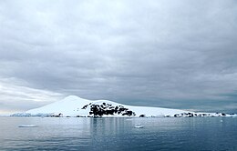
HOVGAARD ISLAND (Krogmann Island) lies close south-westward of Booth Island and is about3 miles long northeast-southwest with an average breadth of about 1 mile. The highest elevation is a well-rounded summit, about 1,200 feet high near the central part of the Island, the ice-covered slopes of which
311:
PLENEAU ISLAND, 177 feet high, lies close off the northeastern extremity of
Hovgaard Island. A shoal area, with rocks which break, is charted within 400 yards eastward of the eastern end of Pleneau Island. There Is a penguin rookery on the northeastern end of the
262:
Hovgaard Island is a popular location for camping in
Antarctica among expedition groups due to the presence of a relatively flat campsite along Penola Strait. Campers dig "snow graves" to sleep in. The holes offer protection from the wind.
961:
877:
174:
90:
982:
965:
881:
928:
689:
44:
328:
665:
340:
211:) is an island 3 nautical miles (5.6 km; 3.5 mi) long, lying 1.5 nautical miles (2.8 km; 1.7 mi) southwest of
677:
518:
480:
442:
388:
547:
653:
276:
641:
417:
629:
367:
713:
362:
765:
357:
147:
943:
905:
Higgins, Anthony K. (2010), "Exploration history and place names of northern East
Greenland: Hovgaard Ø",
581:
284:
617:
605:
593:
569:
416:. Point forming the south end of Hovgaard Island, in the Wilhelm Archipelago. Charted and named by the
421:
235:
Hovgaard Island is off the Graham Coast of the northwest side of the
Antarctic Peninsula. It is in the
888:
701:
236:
216:
134:
280:
271:
Hovgaard Island was discovered and named
Krogmann Island by the German 1873–74 expedition under
937:
924:
914:
352:
244:
272:
231:
Graham Coast, Antarctic
Peninsula. Hovgaar Island south of Booth Island, off the east end
256:
248:
291:. The name Krogmann Point has been given to the western extremity of Hovgaard Island.
976:
252:
854:
240:
212:
551:
288:
78:
28:
533:
520:
495:
482:
457:
444:
403:
390:
190:
176:
106:
92:
919:
939:
Sailing
Directions for Antarctica: Includes Islands South of Latitude 60.̊
227:
324:
226:
753:
424:, 1903–05, after J. Guéguen Point, one of the crew the ship
737:
735:
733:
862:(2 ed.), United States Board on Geographic Names
907:
Geological Survey of
Denmark and Greenland Bulletin
788:
158:
153:
140:
130:
84:
74:
69:
695:Scientist counts Gentoo penguins on Pléneau Island
305:
303:(1976) describes Hovgaard Island as follows:
8:
283:, has overtaken the original name in usage.
21:
671:Gentoo penguin and chicks on Pléneau Island
27:
20:
918:
16:Island in Wilhelm Archipelago, Antarctica
287:was a polar explorer and officer of the
966:National Geospatial-Intelligence Agency
882:United States Board on Geographic Names
836:
824:
812:
800:
776:
766:Camping on Hovgaard Island -- TravelPod
741:
729:
683:Gentoo penguin colony on Pléneau Island
565:
275:, but the name Hovgaard applied by the
255:. It is off the northwest coast of the
51:
890:Graham Land and South Shetland Islands
378:Features and nearby features include:
893:, BAS: British Antarctic Survey, 2005
7:
983:Islands of the Wilhelm Archipelago
964:from websites or documents of the
880:from websites or documents of the
754:Graham Land and South Shetland BAS
247:on the mainland, northeast of the
14:
856:Geographic Names of the Antarctic
329:Copernix annotated satellite view
301:Sailing Directions for Antarctica
960: This article incorporates
955:
876: This article incorporates
871:
712:
700:
688:
676:
664:
659:Gentoo penguin on Pléneau Island
652:
640:
628:
616:
604:
592:
580:
568:
323:
299:The US Defense Mapping Agency's
50:
43:
853:Alberts, Fred G., ed. (1995),
647:Kayakers around Pléneau Island
548:British Graham Land expedition
1:
635:Tourists visit Pléneau Island
277:Belgian Antarctic Expedition
946:. Hydrographic Center, 1976
587:Hovgaard Island, Antarctica
418:French Antarctic Expedition
368:GPX (secondary coordinates)
999:
623:Campers on Hovgaard Island
611:Campers on Hovgaard Island
599:Campers on Hovgaard Island
575:Campers on Hovgaard Island
554:, for the expedition ship
363:GPX (primary coordinates)
338:Map all coordinates using
279:(BelgAE), 1897–99, under
145:
38:
26:
346:Download coordinates as:
920:10.34194/geusb.v21.4735
789:Sailing Directions 1976
148:Antarctic Treaty System
146:Administered under the
962:public domain material
944:Defense Mapping Agency
878:public domain material
550:(BGLE} 1934-37, under
422:Jean-Baptiste Charcot
314:
285:Andreas Peter Hovgaard
232:
358:GPX (all coordinates)
239:. It is southwest of
230:
530: /
492: /
454: /
400: /
237:Wilhelm Archipelago
217:Wilhelm Archipelago
186: /
135:Wilhelm Archipelago
102: /
23:
428:and later, of the
295:Sailing directions
281:Adrien de Gerlache
267:Discovery and name
233:
942:, United States.
930:978-87-7871-292-9
534:65.167°S 64.117°W
496:65.100°S 64.067°W
458:65.133°S 64.133°W
404:65.150°S 64.117°W
191:65.133°S 64.133°W
166:
165:
107:65.133°S 64.133°W
990:
959:
958:
954:
953:
951:
933:
922:
901:
900:
898:
875:
874:
870:
869:
867:
861:
840:
834:
828:
822:
816:
810:
804:
798:
792:
786:
780:
774:
768:
763:
757:
751:
745:
739:
716:
704:
692:
680:
668:
656:
644:
632:
620:
608:
596:
584:
572:
545:
544:
542:
541:
540:
539:-65.167; -64.117
535:
531:
528:
527:
526:
523:
507:
506:
504:
503:
502:
501:-65.100; -64.067
497:
493:
490:
489:
488:
485:
469:
468:
466:
465:
464:
463:-65.133; -64.133
459:
455:
452:
451:
450:
447:
415:
414:
412:
411:
410:
409:-65.150; -64.117
405:
401:
398:
397:
396:
393:
327:
251:and east of the
245:Mount Shackleton
210:
209:
207:
206:
205:
203:
198:
197:
196:-65.133; -64.133
192:
187:
184:
183:
182:
179:
126:
125:
123:
122:
121:
119:
114:
113:
112:-65.133; -64.133
108:
103:
100:
99:
98:
95:
54:
53:
47:
31:
24:
998:
997:
993:
992:
991:
989:
988:
987:
973:
972:
971:
956:
949:
947:
936:
931:
904:
896:
894:
887:
872:
865:
863:
859:
852:
848:
843:
835:
831:
823:
819:
811:
807:
799:
795:
787:
783:
775:
771:
764:
760:
752:
748:
740:
731:
727:
720:
717:
708:
705:
696:
693:
684:
681:
672:
669:
660:
657:
648:
645:
636:
633:
624:
621:
612:
609:
600:
597:
588:
585:
576:
573:
564:
538:
536:
532:
529:
524:
521:
519:
517:
516:
514:
500:
498:
494:
491:
486:
483:
481:
479:
478:
476:
462:
460:
456:
453:
448:
445:
443:
441:
440:
438:
408:
406:
402:
399:
394:
391:
389:
387:
386:
384:
376:
375:
374:
373:
372:
333:
332:
331:
319:
297:
273:Eduard Dallmann
269:
243:, northwest of
225:
202:Hovgaard Island
201:
199:
195:
193:
189:
188:
185:
180:
177:
175:
173:
172:
169:Hovgaard Island
118:Hovgaard Island
117:
115:
111:
109:
105:
104:
101:
96:
93:
91:
89:
88:
65:
64:
63:
62:
61:
60:
59:
58:Hovgaard Island
55:
34:
33:Hovgaard Island
22:Hovgaard Island
17:
12:
11:
5:
996:
994:
986:
985:
975:
974:
970:
969:
934:
929:
913:, Copenhagen,
902:
885:
849:
847:
844:
842:
841:
839:, p. 567.
829:
827:, p. 580.
817:
815:, p. 405.
805:
803:, p. 299.
793:
791:, p. 167.
781:
769:
758:
746:
744:, p. 349.
728:
726:
723:
722:
721:
718:
711:
709:
707:Pléneau Island
706:
699:
697:
694:
687:
685:
682:
675:
673:
670:
663:
661:
658:
651:
649:
646:
639:
637:
634:
627:
625:
622:
615:
613:
610:
603:
601:
598:
591:
589:
586:
579:
577:
574:
567:
563:
560:
513:
510:
475:
474:Pléneau Island
472:
437:
436:Krogmann Point
434:
383:
380:
371:
370:
365:
360:
355:
349:
343:
336:
335:
334:
322:
321:
320:
318:
315:
296:
293:
268:
265:
257:Kyiv Peninsula
249:French Passage
224:
221:
219:, Antarctica.
164:
163:
160:
156:
155:
151:
150:
143:
142:
141:Administration
138:
137:
132:
128:
127:
86:
82:
81:
76:
72:
71:
67:
66:
57:
56:
49:
48:
42:
41:
40:
39:
36:
35:
32:
15:
13:
10:
9:
6:
4:
3:
2:
995:
984:
981:
980:
978:
967:
963:
945:
941:
940:
935:
932:
926:
921:
916:
912:
908:
903:
892:
891:
886:
883:
879:
858:
857:
851:
850:
845:
838:
833:
830:
826:
821:
818:
814:
809:
806:
802:
797:
794:
790:
785:
782:
778:
773:
770:
767:
762:
759:
755:
750:
747:
743:
738:
736:
734:
730:
724:
719:Penola Strait
715:
710:
703:
698:
691:
686:
679:
674:
667:
662:
655:
650:
643:
638:
631:
626:
619:
614:
607:
602:
595:
590:
583:
578:
571:
566:
561:
559:
557:
553:
549:
543:
512:Penola Strait
511:
509:
505:
473:
471:
467:
435:
433:
431:
430:Pourquoi-Pas?
427:
423:
420:(FrAE) under
419:
413:
382:Guéguen Point
381:
379:
369:
366:
364:
361:
359:
356:
354:
351:
350:
348:
347:
342:
341:OpenStreetMap
339:
330:
326:
316:
313:
309:
304:
302:
294:
292:
290:
286:
282:
278:
274:
266:
264:
260:
258:
254:
253:Vedel Islands
250:
246:
242:
238:
229:
222:
220:
218:
214:
208:
170:
161:
157:
152:
149:
144:
139:
136:
133:
129:
124:
87:
83:
80:
77:
73:
68:
46:
37:
30:
25:
19:
948:, retrieved
938:
910:
906:
895:, retrieved
889:
864:, retrieved
855:
837:Alberts 1995
832:
825:Alberts 1995
820:
813:Alberts 1995
808:
801:Alberts 1995
796:
784:
777:Higgins 2010
772:
761:
749:
742:Alberts 1995
555:
515:
477:
439:
429:
425:
385:
377:
345:
344:
337:
310:
306:
300:
298:
270:
261:
241:Booth Island
234:
213:Booth Island
168:
167:
154:Demographics
18:
552:John Rymill
537: /
499: /
461: /
432:, 1908-10.
407: /
289:Danish Navy
194: /
162:Uninhabited
131:Archipelago
110: /
85:Coordinates
866:3 December
725:References
200: (
159:Population
116: (
79:Antarctica
70:Geography
977:Category
426:Francais
317:Features
223:Location
75:Location
846:Sources
562:Gallery
525:64°07′W
522:65°10′S
487:64°04′W
484:65°06′S
449:64°08′W
446:65°08′S
395:64°07′W
392:65°09′S
312:island.
215:in the
950:30 May
927:
556:Penola
181:64°8′W
178:65°8′S
97:64°8′W
94:65°8′S
897:3 May
860:(PDF)
952:2024
925:ISBN
899:2024
868:2023
915:doi
353:KML
979::
923:,
911:21
909:,
732:^
558:.
259:.
968:.
917::
884:.
779:.
756:.
204:)
171:(
120:)
Text is available under the Creative Commons Attribution-ShareAlike License. Additional terms may apply.