587:. Where previously maps had been under close guard, availability began to increase. Not only that, but the significance of cartographic depiction followed a similar trend and geographical connotations were no longer limiting the way maps were developed. In order to figure the best way to establish control of sovereign land, government officials of Spain began to record, in mass detail, about the territorial land of said establishments. They did not do this without significant prompting, but it still occurred. The information obtained to fill the requirements to take record was often taken from merchants who could provide accurate information based upon experience. Utilizing the significant information allowed for the Spanish empire to develop appropriate policies to incorporate into the expanding areas. While the extreme precautions taken to keep Spanish maps hidden might allude to the fact that maps were not a part of the imperial effort that was not the case. Maps were very much a part of the self-representations of Spain, which was able to show itself as an Atlantic empire through the cartographic lens. Through their efforts and ambitions, which were visually recorded on the relatively few Spanish maps that survived, Spain was able to facilitate a persistence of cultural trends. Delving deeper into that, a representation of it can be made through the relationship between Spain and America, which is where a geometric rationalization really began to occur through cartography in terms of space. It was in the late sixteenth century when Spain was able to represent this idea through rationalizing the American Empire, which was beginning to spread a bit too thinly.
639:, which was dated 1375. When the Portuguese explored coasts, for example the coast of West Africa, cartographers and navigators would carefully record progress. They were sure to include the names of the places they encountered, as well as doing their best to draw the coast. Unlike Spain, however, despite the fact that there was supposedly a policy of secrecy attached to these records, it was quite often that as soon as data from the voyages was obtained, it was almost instantly recorded for public use and knowledge. Specifically, cartographers began to include actual definition in the territorial land. Cities, rivers, and mountain ranges all began to show up on some maps, whereas others still just included the bare minimum of the outline of the coast. Building from that, maps began to take on an ornamental value. No longer were the purposes just restrained to the seeking of political and economic knowledge, but they became decorative. Building upon the evolution of cartography, the Portuguese went from simply incorporating the waters they traveled to incorporating land masses such as cities, mountains, and rivers. The Portuguese expanded map-making even further by the introduction of the representation of wind systems in the making of their maps.
501:, maps began to grow into a greater, fantasy-inspired style. Where beforehand, the descriptiveness was minimal, maps now included beautiful drawings of angels and mythical creatures, and oftentimes these maps were used to understand what was considered to be the history. In the 15th century, maps began to develop an idea and representation of distinctive frontiers. Where the previous maps had indulged in fantastical depictions, terminology began to show up much more frequently now, such as names for regions and provinces. The influence of an eastern orientation was one of the first things to change from the typical features of maps with the loss of fantastical creatures being depicted and the inclusion of more detailed landmasses, and it is possible that this was happening because Arabic influence was causing maps orientation to move away from the east and more toward the south.
643:
their map-making, they still relied heavily on the cartographical knowledge of others, such as the Arabs, Japanese, and
Chinese, when it came down to the actual observing and mapping of the global world. They did obtain their own information, but the maps were visibly a mixture of those observations, as well as other information that they had taken from other experts on cartography. The knowledge and the methods of obtaining information used by Portuguese cartographers drew upon the skill and knowledge of Muslim navigators. That being said, they still would conduct their own evaluations by writing down details they obtained when at port in other areas. The same applied to how they obtained some of their information of the land masses that were beginning to show up more and more in maps, opposed to the former method of just applying information regarding to the seas and oceans.
594:. The actual numerical amount of the maps is unknown, but it isn't thought to have been particularly low. The thing was, however, that they only existed in a manuscript form, and still only certain people were able to get their hands on said manuscript. That is still an improvement from how strictly the Spanish were guarding their maps in earlier centuries, but there was still an air of that protectiveness. For the most part, only people who were involved in the exploration or conquest of the New World were able to obtain the maps. There were a few exceptions to that particular rule that included people who were well-versed in Latin, educational publications for the learned, or being produced for those who were not within the boundaries of the Iberian land. Average readers who wanted to look at such a map would either have to gain access to a
615:, dates back to 1485. Within the first fleets that were sent into the East by Portugal of which there were hopes to develop an economic and trade relationship between the two empires, the leaders of the expedition specifically hired pilots who would be able to gather accurate information in a geographical and navigational sense about the Indian Ocean. There was a map smuggled into Italy in 1502 of Portuguese origin that was documented evidence that the before mentioned pilots were able to gather accurate information, and with that, they created a picture of eastern Africa and western India that was both detailed and valid. As previously mentioned, not only did cartography have a cooperative relationship with the establishment of commerce, but the same applied in a reverse relationship as well. The early expeditions created the well-known
535:
with the compass to gather ones bearings. Oftentimes the charts did not include any information on inland structures. There were exceptions, but they were few and usually limited to library copies. Not all maps designating information that would be most beneficial to
Iberian empires were being produced in Portugal or Spain, and the same applied to the information utilized by the Portolan charts. Other maps were being produced in Italy and in Germany, both of which were incorporating not just geographical ideas, but religious and academic ideas as well. At the same time, they were using the information that Portuguese seamen had ambitiously acquired. The charts of sailing directions expanded as new sailing routes became more prominent, such as what happened when the
531:, allowing sailors to venture out farther onto the open water without as significant of a fear of the hopelessness of getting lost. The manufacturer of the chart would draw a scaled distance along with compass bearings to create angles in order to connect the different areas. Using the chart, the sailor or navigator would set a course from one point to the next, and then use what are known as rhumb lines, which are lines of longitude that all cross the meridian at exactly the same angle, to translate the desired course onto a compass heading.
572:
456:, which was created through a series of maps being bound together. The new innovation was not just for show, however, as it had many practical uses due to its improved portability and durability, as well as making it easier for the readers to see. Map-making technique began an alteration through geographical thought. While not every map looked the same, a pattern of features developed through the round shape and typical inclusion of some sort of paradise, and were found on many of the maps of that time.
236:
387:
272:
510:
488:, dealt with the latitude parallels consisting of round arcs. The second, known as a pseudoconic projection, consisted of longitude lines being round. Ptolemy's work were heavily influential in Islamic science as well, whose maps were quite similar to the Portolan charts and were partly influential on the Catalan map by Abraham Cresques. In the early 14th century, many of the maps were known as
121:
623:
22:
553:
into undesirable hands was done by the prohibition of any of the maps to appear in print. This prevented anybody who was not an active involved person in the business of Spain's empire to view the maps. With the printing of
Spanish maps not just discouraged, but entirely restricted, there are very few that have survived. Cartography was not at all absent from the
557:. Quite the contrary, they were used as an imperial effort to self-represent themselves as an Atlantic or global empire. A majority of this focus was placed upon the Indies and creating a spatial representation of structures that they had yet to examine, but needed to integrate with geographical data that they had already obtained in order to develop maps.
63:
460:
568:. At time, through cartography, Spanish culture has been able to elaborate on more than a two-dimensional idea of space, especially in the instances where climates are shown as a 'portion of the sphere.' That being said, outside of cartography, there is a lack of the idea of space in other aspects of the culture.
402:
Even still, oftentimes before the availability of maps began to increase, they were used as decorative pieces that were commonly gifted to individuals of very high social status such as kings or popes. Those particular maps frequently had descriptive legends, which usually consisted of drawings being
382:
began to appear on maps. they made maritime activities such as exploration or conquest less time- and resource-consuming. Maps were also used as a method to plan out landmasses by surveyors in areas that had yet to be explored or did not have many documented statistics. This often was the case in the
451:
Evolutionary-wise, the specific measurements used in sea charts began to have a practical impact on world maps beginning in the early 14th century with the inclusion of latitude and longitude. Before hand, cartographic works had been developed through less rational methods than mathematical, such as
642:
Once they began to correctly understand the wind systems in both the Indian and
Atlantic Oceans, they were able to use that knowledge in order to expand their global trade routes even further, which in turn established an even further spread out empire. While the Portuguese were very innovative in
610:
Cartography played a large role in the establishment of the expansive
Portuguese trade route, and similarly, the trade route played its role in Portuguese cartography. Maps included certain knowledge obtained solely through the connections Portugal had made through their trade routes in Africa and
552:
heavily guarded the maps and their advanced level of geographical knowledge because they did not want any of their rivals to be able to obtain them in any way to use against them or to use in order to expand their own empires into lands that Spain was eying. The protection of the maps from falling
534:
The charts included descriptive depictions of coastlines, as well as islands, which enabled seafarers who were accustomed to using such navigational tools as the compass to find their way to said coasts and islands at sea. Included on the chart were a series of thick lines that would be used along
582:
With landmass structures, opposed to the original ocean-focus, becoming more popular on maps, two things began to change when it came to
Spanish cartography. First of all, space was being considered in a different light, and secondly, the way maps were drawn began to change as well. Many of these
646:
As time progressed into the late sixteenth century, Portugal’s ocean-based trade routes began to become more widely known. While their maps were not nearly as heavily guarded as those under the
Habsburg rule in Spain, they were still kept within Portugal. That began to change when those maps had
634:
It is important to note that not all of the information on charts and maps were limited to the seas and oceans, or even the coastlines for that matter. That was primarily the case, but there were exceptions. There were copies of maps that did include information about land areas past the coast,
526:
began to surface just prior to the beginning of the 14th century, but the division of such a practical creation was very significant in the map-making world. They were specifically used to solve specific problems. Each chart was an individual, which is important in comparison to the typical map,
496:
which was developed a few centuries beforehand, but was also the first map to actually be printed in 1472. Some of these earlier maps relied heavily on Arabic influence, which is evident in the inclusion of frequent Arabic place names. It is thought that this information could have been gathered
539:
were initially discovered, followed by the discovery of other
Atlantic islands. As was the case with general map-making, some of the charts began to incorporate decorative depictions in them as well. Navigational instruments like these did not just have a significant impact on the idea of space
521:
which translates from
Italian into 'pilot's book.' While the orientation of earlier maps was generally in the east, and then it moved southward with the Arabic influence established throughout various trade routes, Portolan charts were oriented to the north to make them easier to read.
492:, termed because of a circle representing the earth, and within the circle a T-shape to designate the division of different known land masses, which were Europe, Africa, and Asia. This particular style was representative in the well-known Spanish
426:
against Spain. In relation to both Spain and
Portugal and their influences on each other in terms of cartography, there was one very significant and fairly obvious example that began to develop in the 15th century. The Portuguese had begun to use
497:
through experiences throughout different trade routes. The T-O style of map shows a lack of information regarding the specific details of land masses, but once trade began to flourish, so did the detail in maps. Following the simplicity of the
540:
through the Iberian empires, but they also played a role in mobility as well. With the use of practical tools like the Portolan charts, people were able to more successful navigate and respectively move class-wise based upon said success.
527:
which had to be studied often with some sort of text to accompany it. The development of Portolan charts is thought to have begun due to an increasing overseas trade empire. Portolan charts were produced with a combination of chart and
398:
model, where observed latitudes and magnetic directions are plotted directly into the plane, with a constant scale, as if the Earth were plane (Portuguese National Archives of Torre do Tombo, Lisbon).
374:
They were used to make the travel occurring at the time easier by eliminating the unnecessary resources spent when the most efficient route was not taken, and after things such as wind patterns and
422:, and in those circumstances they were used to possibly distort or falsify information. The Dutch used a particular map, which was known as the 'Christian knight map' for this purpose during their
619:, but they also were cause of the gathering of information dealing with trade within the Indian Ocean region, which was important in the establishment of Portugal's expansive trade routes.
635:
though they were usually reserved for library use. An example of a map that did include land information, as well as trade information that surpassed what was typically on a map, was the
1256:
513:
Portolan chart by Jorge de Aguiar (1492), the oldest known signed and dated chart of Portuguese origin (Beinecke Rare Book and Manuscript Library, University of Yale, New Haven, USA)
484:
played a large role in the development of cartography once it was translated into Latin in 1406. Ptolemy projected two different types of maps in his text. The first, known as a
655:
under colonial rule. Displacement of these indigenous populations did occur in under a cartographic lens, but despite that, a representation of imperial space was established.
138:
35:
1117:
185:
674:
340:
157:
669:
41:
647:
started to appear abroad. Not only that, but Portuguese navigators began to take positions in other countries, which furthered the spread of the
452:
theology and cosmology, but did include statements of geography and history as well. The beginning of the 14th century also introduced the first
164:
1266:
694:
363:, all its territories with seashore on the Mediterranean Sea. The Crown of Aragon controlled the routes across the Mediterranean Sea from the
565:
73:
171:
84:
1346:
560:
As mentioned previously, the revolution of Ptolemy’s rational thinking was what created such a powerful period in time when it came to
590:
As time progressed into the 16th century, the development of Spanish maps began to increase, primarily those that were depicting the
153:
222:
204:
102:
49:
1212:
1110:
1419:
1409:
142:
611:
the East, although many of the maps unfortunately did not survive. The oldest signed Portuguese nautical chart, created by
1414:
684:
1103:
474:
To better understand the map-making process, a step back in time is required, as Claudius Ptolemaeus, better known as
178:
548:
Unlike the maps being created in Portugal, those produced in Spain were heavily guarded with an air of secrecy. The
1424:
1202:
564:, because it was uniting transparency with yet-to-be-realized political function. Spain utilized this through its
131:
1172:
360:
311:
1233:
1197:
1192:
439:, the same lines began to appear on Spanish charts as well, which eventually developed into what is known as a
1187:
627:
419:
256:
1334:
1289:
1248:
1207:
679:
1384:
1228:
1156:
1146:
296:
235:
77:
that states a Knowledge (XXG) editor's personal feelings or presents an original argument about a topic.
571:
391:
383:
Americas, where the Iberian empires did not start off with much documented evidence of the landmasses.
271:
1182:
1079:
The Confines of Colony: Boundaries, Ethnographic Landscapes, and Imperial Cartography in Iberoamerica
364:
1340:
1151:
480:
352:
307:
386:
1177:
651:
in other nations. The Portuguese also attempted to utilize cartography in order to integrate the
599:
464:
356:
303:
284:
248:
652:
648:
348:
332:
315:
292:
280:
1311:
1141:
1082:
664:
436:
264:
244:
523:
412:
344:
276:
252:
343:
for maritime folk such as explorers, sailors and navigators. Mostly the expansion of the
403:
integrated into the actual map. An example of such a map would be the heavily decorated
554:
549:
536:
485:
440:
408:
260:
1403:
1317:
862:
688:
636:
404:
240:
509:
1379:
1238:
612:
595:
423:
1078:
973:
893:
805:
764:
749:
731:
1363:
1126:
616:
561:
493:
489:
467:
432:
428:
326:
120:
622:
1294:
1014:
The Spacious World: Cartography, Literature, and Empire in Early Modern Spain
1001:
The Spacious World: Cartography, Literature, and Empire in Early Modern Spain
988:
The Spacious World: Cartography, Literature, and Empire in Early Modern Spain
960:
The Spacious World: Cartography, Literature, and Empire in Early Modern Spain
947:
The Spacious World: Cartography, Literature, and Empire in Early Modern Spain
934:
The Spacious World: Cartography, Literature, and Empire in Early Modern Spain
877:
The Spacious World: Cartography, Literature, and Empire in Early Modern Spain
765:
The Spacious World: Cartography, Literature, and Empire in Early Modern Spain
591:
584:
379:
368:
921:
The World Map, 1300–1492: The Persistence of Tradition and Transformation
849:
The World Map, 1300–1492: The Persistence of Tradition and Transformation
820:
The World Map, 1300–1492: The Persistence of Tradition and Transformation
779:
The World Map, 1300–1492: The Persistence of Tradition and Transformation
750:
The World Map, 1300–1492: The Persistence of Tradition and Transformation
717:
The World Map, 1300–1492: The Persistence of Tradition and Transformation
697:, influenced by early modern Iberian (Spanish and Portuguese) cartography
375:
528:
498:
475:
299:
1095:
288:
390:
A pre-Mercator nautical chart of 1571, from Portuguese cartographer
621:
570:
508:
459:
458:
453:
385:
331:
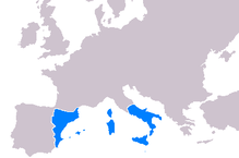
played a significant role in the expansion of the kingdoms of the
270:
234:
576:
Americae Sive Qvartae Orbis Partis Nova Et Exactissima Descriptio
974:
The First imperial Age: European Overseas Expansion c. 1400-1715
1099:
719:. Maryland, U.S.A.: Johns Hopkins University Press. p. 55.
283:, and by the 14th-16th centuries, its territories included the
367:
to Europe, as part of the commercial-trade route known as the
336:
114:
56:
15:
923:. (Maryland, Johns Hopkins University Press: 2007) p. 53–58
806:
Maps & Civilization: Cartography in Culture and Society
583:
changes were happening in result of the exploration of the
407:, which was produced in 1375. It was used as a gift to the
74:
personal reflection, personal essay, or argumentative essay
1027:
To The Ends of the Earth: 100 Maps That Changed the World.
792:
To The Ends of the Earth: 100 Maps That Changed the World.
695:
Early modern Netherlandish (Dutch and Flemish) cartography
431:
of latitude on their nautical charts, and once Portuguese
851:. (Maryland, Johns Hopkins University Press: 2007) p. 202
836:
To The Ends of the Earth: 100 Maps That Changed the World
732:
To The Ends of the Earth: 100 Maps That Changed the World
822:. (Maryland, Johns Hopkins University Press: 2007) p. 69
1087:
The Imperial Map: Cartography and the Mastery of Empire
990:. (Chicago, University of Chicago Press: 2004) p. 12–13
949:. (Chicago, University of Chicago Press: 2004) p. 40–49
781:(Maryland, Johns Hopkins University Press: 2007) p. 165
80:
753:(Maryland, Johns Hopkins University Press: 2007) p. 55
606:
Portuguese oceanic and land exploration and navigation
320:
All these united under one Crown, the Crown of Aragon.
1089:. (Chicago, University of Chicago Press: 2009) p. 178
1016:. (Chicago, University of Chicago Press: 2004) p. 118
879:(Chicago, University of Chicago Press: 2004) p. 61–62
1066:
A History of Portuguese Overseas Expansion 1400–1668
1053:
A History of Portuguese Overseas Expansion 1400–1668
1040:
A History of Portuguese Overseas Expansion 1400–1668
1003:. (Chicago, University of Chicago Press: 2004) p. 39
962:. (Chicago, University of Chicago Press: 2004) p. 32
936:. (Chicago, University of Chicago Press: 2004) p. 13
908:
A History of Portuguese Overseas Expansion 1400–1668
894:
A History of Portuguese Overseas Expansion 1400–1668
809:. (Chicago, University of Chicago Press: 2008) p. 56
251:'s cartographer. It was a gift from the King of the
1372:
1356:
1327:
1304:
1282:
1275:
1247:
1221:
1165:
1134:
544:
Spanish oceanic and land exploration and navigation
145:. Unsourced material may be challenged and removed.
768:(Chicago, University of Chicago Press: 2004) p. 65
863:The World Through Maps: A History of Cartography
394:(c. 1520–c. 1580). It belongs to the so-called
830:
828:
279:began its expansion in the 13th century under
1111:
8:
838:. (London, Marshall Editions: 2006) p. 32–51
335:for a multitude of reasons. Primarily, the
50:Learn how and when to remove these messages
1279:
1118:
1104:
1096:
887:
885:
866:. (Canada, Firefly Books, ltd: 2003) p.62
743:
741:
223:Learn how and when to remove this message
205:Learn how and when to remove this message
103:Learn how and when to remove this message
735:. (London, Marshall Editions: 2006) p. 8
1068:. (Milton Park, Routledge: 2005) p. 203
1055:. (Milton Park, Routledge: 2005) p. 265
1029:(London, Marshall Editions: 2006) p. 73
794:(London, Marshall Editions: 2006) p. 22
707:
339:developed during this period served as
1267:Early modern Netherlandish cartography
1042:. (Milton Park, Routledge: 2005) p. 62
910:. (Milton Park, Routledge: 2005) p. 48
626:"Terra Brasilis", Miller Atlas, 1519,
897:. (Milton Park, Routledge: 2005) p. 7
517:The term portolan is derivative from
7:
977:. (London, Unwin Hyman: 1989) p. 218
675:Iberian nautical sciences, 1400–1600
143:adding citations to reliable sources
670:Iberian ship development, 1400–1600
478:, whose eight-volume work entitled
447:Evolution of the map-making process
239:Dating from 1375, the full 8 sheet
418:One other purpose behind maps was
329:throughout the 14th-16th centuries
14:
31:This article has multiple issues.
1347:Cosmographia (Sebastian Münster)
1262:Early modern Iberian cartography
154:"Iberian cartography, 1400–1600"
119:
61:
20:
729:Sarah Bendall. "Introduction."
130:needs additional citations for
39:or discuss these issues on the
1:
1257:Medieval Islamic cartography
685:Majorcan cartographic school
435:were being recruited by the
263:are copies of this original
1441:
971:Geoffrey Vaughn Scammell.
424:struggle for independence
361:Principality of Catalonia
312:Principality of Catalonia
628:French National Library
1420:History of cartography
1410:Cartography by country
1335:Map of Juan de la Cosa
715:Edson, Evelyn (2007).
680:Portuguese discoveries
631:
579:
514:
471:
399:
322:
268:
259:. Many later maps and
249:King Pere IV of Aragon
83:by rewriting it in an
1385:Points of the compass
803:Norman J.W. Thrower.
625:
574:
512:
462:
411:from the King of the
389:
274:
238:
1415:History of geography
1166:By country or region
365:Kingdom of Jerusalem
359:, together with the
347:(which included the
139:improve this article
1341:Cantino planisphere
1290:Ptolemy's world map
353:Kingdom of Valencia
308:Kingdom of Valencia
304:Kingdom of Mallorca
632:
600:woodcut production
598:version or find a
580:
515:
472:
400:
392:Fernão Vaz Dourado
357:Kingdom of Majorca
341:navigational tools
323:
285:Duchy of Neopatras
269:
85:encyclopedic style
72:is written like a
1425:Iberian Peninsula
1397:
1396:
1393:
1392:
653:indigenous people
649:Portuguese Empire
349:Kingdom of Aragon
333:Iberian Peninsula
316:Kingdom of Aragon
300:, isle of Corsica
293:Kingdom of Sicily
281:James I of Aragon
261:"portolan charts"
233:
232:
225:
215:
214:
207:
189:
113:
112:
105:
54:
1432:
1357:Contemporary age
1328:Early Modern age
1312:Tabula Rogeriana
1280:
1120:
1113:
1106:
1097:
1090:
1083:James R. Akerman
1075:
1069:
1062:
1056:
1049:
1043:
1036:
1030:
1025:Jeremy Harwood.
1023:
1017:
1012:Ricardo Padrón.
1010:
1004:
999:Ricardo Padrón.
997:
991:
986:Ricardo Padrón.
984:
978:
969:
963:
958:Ricardo Padrón.
956:
950:
945:Ricardo Padrón.
943:
937:
932:Ricardo Padrón.
930:
924:
917:
911:
904:
898:
889:
880:
875:Ricardo Padrón.
873:
867:
858:
852:
845:
839:
834:Jeremy Harwood.
832:
823:
816:
810:
801:
795:
790:Jeremy Harwood.
788:
782:
775:
769:
762:Ricardo Padrón.
760:
754:
745:
736:
727:
721:
720:
712:
665:Age of Discovery
486:conic projection
437:Crown of Castile
297:Isle of Sardinia
245:Abraham Cresques
228:
221:
210:
203:
199:
196:
190:
188:
147:
123:
115:
108:
101:
97:
94:
88:
65:
64:
57:
46:
24:
23:
16:
1440:
1439:
1435:
1434:
1433:
1431:
1430:
1429:
1400:
1399:
1398:
1389:
1368:
1352:
1323:
1300:
1276:Individual maps
1271:
1243:
1217:
1161:
1130:
1124:
1094:
1093:
1076:
1072:
1063:
1059:
1050:
1046:
1037:
1033:
1024:
1020:
1011:
1007:
998:
994:
985:
981:
970:
966:
957:
953:
944:
940:
931:
927:
918:
914:
905:
901:
890:
883:
874:
870:
860:John R. Short.
859:
855:
846:
842:
833:
826:
817:
813:
802:
798:
789:
785:
776:
772:
761:
757:
746:
739:
728:
724:
714:
713:
709:
704:
661:
608:
566:American empire
546:
524:Portolan charts
507:
505:Portolan charts
463:Copy (1475) of
449:
413:Crown of Aragon
345:Crown of Aragon
277:Crown of Aragon
253:Crown of Aragon
229:
218:
217:
216:
211:
200:
194:
191:
148:
146:
136:
124:
109:
98:
92:
89:
81:help improve it
78:
66:
62:
25:
21:
12:
11:
5:
1438:
1436:
1428:
1427:
1422:
1417:
1412:
1402:
1401:
1395:
1394:
1391:
1390:
1388:
1387:
1382:
1376:
1374:
1370:
1369:
1367:
1366:
1360:
1358:
1354:
1353:
1351:
1350:
1344:
1338:
1331:
1329:
1325:
1324:
1322:
1321:
1315:
1308:
1306:
1302:
1301:
1299:
1298:
1292:
1286:
1284:
1277:
1273:
1272:
1270:
1269:
1264:
1259:
1253:
1251:
1245:
1244:
1242:
1241:
1236:
1231:
1225:
1223:
1219:
1218:
1216:
1215:
1210:
1205:
1200:
1195:
1190:
1185:
1180:
1175:
1169:
1167:
1163:
1162:
1160:
1159:
1154:
1149:
1144:
1138:
1136:
1132:
1131:
1125:
1123:
1122:
1115:
1108:
1100:
1092:
1091:
1077:Neil Safier. "
1070:
1064:Malyn Newitt.
1057:
1051:Malyn Newitt.
1044:
1038:Malyn Newitt.
1031:
1018:
1005:
992:
979:
964:
951:
938:
925:
919:Evelyn Edson.
912:
906:Malyn Newitt.
899:
891:Malyn Newitt.
881:
868:
853:
847:Evelyn Edson.
840:
824:
818:Evelyn Edson.
811:
796:
783:
777:Evelyn Edson.
770:
755:
747:Evelyn Edson.
737:
722:
706:
705:
703:
700:
699:
698:
692:
682:
677:
672:
667:
660:
657:
607:
604:
555:Spanish empire
545:
542:
537:Canary Islands
506:
503:
448:
445:
409:King of France
257:King of France
231:
230:
213:
212:
127:
125:
118:
111:
110:
69:
67:
60:
55:
29:
28:
26:
19:
13:
10:
9:
6:
4:
3:
2:
1437:
1426:
1423:
1421:
1418:
1416:
1413:
1411:
1408:
1407:
1405:
1386:
1383:
1381:
1378:
1377:
1375:
1371:
1365:
1362:
1361:
1359:
1355:
1348:
1345:
1342:
1339:
1336:
1333:
1332:
1330:
1326:
1319:
1318:Catalan Atlas
1316:
1313:
1310:
1309:
1307:
1303:
1296:
1293:
1291:
1288:
1287:
1285:
1281:
1278:
1274:
1268:
1265:
1263:
1260:
1258:
1255:
1254:
1252:
1250:
1246:
1240:
1237:
1235:
1232:
1230:
1227:
1226:
1224:
1220:
1214:
1213:United States
1211:
1209:
1206:
1204:
1201:
1199:
1196:
1194:
1191:
1189:
1186:
1184:
1181:
1179:
1176:
1174:
1171:
1170:
1168:
1164:
1158:
1155:
1153:
1150:
1148:
1145:
1143:
1140:
1139:
1137:
1133:
1128:
1121:
1116:
1114:
1109:
1107:
1102:
1101:
1098:
1088:
1084:
1080:
1074:
1071:
1067:
1061:
1058:
1054:
1048:
1045:
1041:
1035:
1032:
1028:
1022:
1019:
1015:
1009:
1006:
1002:
996:
993:
989:
983:
980:
976:
975:
968:
965:
961:
955:
952:
948:
942:
939:
935:
929:
926:
922:
916:
913:
909:
903:
900:
896:
895:
888:
886:
882:
878:
872:
869:
865:
864:
857:
854:
850:
844:
841:
837:
831:
829:
825:
821:
815:
812:
808:
807:
800:
797:
793:
787:
784:
780:
774:
771:
767:
766:
759:
756:
752:
751:
744:
742:
738:
734:
733:
726:
723:
718:
711:
708:
701:
696:
693:
690:
689:Catalan chart
686:
683:
681:
678:
676:
673:
671:
668:
666:
663:
662:
658:
656:
654:
650:
644:
640:
638:
637:Catalan Atlas
629:
624:
620:
618:
614:
605:
603:
601:
597:
593:
588:
586:
577:
573:
569:
567:
563:
558:
556:
551:
543:
541:
538:
532:
530:
525:
520:
511:
504:
502:
500:
495:
491:
487:
483:
482:
477:
470:of the world.
469:
466:
465:St. Isidore's
461:
457:
455:
446:
444:
442:
438:
434:
433:cosmographers
430:
425:
421:
416:
414:
410:
406:
405:Catalan Atlas
397:
393:
388:
384:
381:
377:
372:
370:
366:
362:
358:
354:
350:
346:
342:
338:
334:
330:
328:
321:
317:
313:
309:
305:
301:
298:
294:
290:
286:
282:
278:
273:
266:
262:
258:
254:
250:
246:
242:
241:Catalan Atlas
237:
227:
224:
209:
206:
198:
187:
184:
180:
177:
173:
170:
166:
163:
159:
156: –
155:
151:
150:Find sources:
144:
140:
134:
133:
128:This article
126:
122:
117:
116:
107:
104:
96:
86:
82:
76:
75:
70:This article
68:
59:
58:
53:
51:
44:
43:
38:
37:
32:
27:
18:
17:
1380:Compass rose
1261:
1135:By continent
1086:
1073:
1065:
1060:
1052:
1047:
1039:
1034:
1026:
1021:
1013:
1008:
1000:
995:
987:
982:
972:
967:
959:
954:
946:
941:
933:
928:
920:
915:
907:
902:
892:
876:
871:
861:
856:
848:
843:
835:
819:
814:
804:
799:
791:
786:
778:
773:
763:
758:
748:
730:
725:
716:
710:
645:
641:
633:
613:Pedro Reinel
609:
596:black market
589:
581:
575:
559:
547:
533:
518:
516:
490:T and O maps
479:
473:
450:
417:
401:
395:
373:
325:
324:
319:
219:
201:
192:
182:
175:
168:
161:
149:
137:Please help
132:verification
129:
99:
90:
71:
47:
40:
34:
33:Please help
30:
1364:Cassini map
1297:(Sec. V BC)
1283:Ancient age
1203:Switzerland
1193:New Zealand
1127:Cartography
617:Cantino map
562:cartography
494:Mappa Mundi
468:T and O map
441:plane chart
396:plane chart
327:Cartography
287:(in actual
1404:Categories
1305:Middle age
1295:Soleto Map
702:References
420:propaganda
247:, who was
165:newspapers
36:improve it
1234:Jerusalem
1198:Palestine
1142:The World
592:New World
585:New World
550:Habsburgs
519:portolano
499:T-O style
481:Geography
380:longitude
369:Silk Road
195:June 2011
93:June 2011
42:talk page
1373:See also
659:See also
376:latitude
243:made by
1249:History
1222:By city
1208:Ukraine
1188:Jamaica
1085:(ed.).
529:compass
476:Ptolemy
265:Catalan
255:to the
179:scholar
79:Please
1349:(1544)
1343:(1502)
1337:(1500)
1320:(1375)
1314:(1154)
1229:Dublin
1178:France
1157:Europe
1147:Africa
1129:topics
1081:." in
578:, 1562
429:scales
289:Greece
181:
174:
167:
160:
152:
1183:India
1173:China
454:atlas
186:JSTOR
172:books
1239:York
1152:Asia
378:and
355:and
337:maps
314:and
275:The
267:one.
158:news
302:,
291:),
141:by
1406::
884:^
827:^
740:^
602:.
443:.
415:.
371:.
351:,
318:.
310:,
306:,
295:,
45:.
1119:e
1112:t
1105:v
691:)
687:(
630:.
226:)
220:(
208:)
202:(
197:)
193:(
183:·
176:·
169:·
162:·
135:.
106:)
100:(
95:)
91:(
87:.
52:)
48:(
Text is available under the Creative Commons Attribution-ShareAlike License. Additional terms may apply.