36:
17:
25:
157:
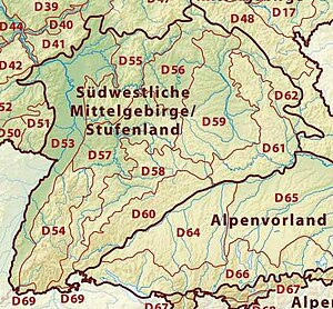
map. In the following table these sub-divisions are described from west to east. For the exact location and boundaries of the individual sub-divisions: see the BfN's map
1477:
1465:
1023:
Relatively high proportion of forest and grassland (on the
Stauden Plateau higher than in the more northern area of the Zusam Plateau and Stauffenberg region)
35:
392:
In the transition zone between the silted-up areas and the Young Drift moraines the reeds and wetlands vegetation gives way to stands of coniferous forest
1242:
Meadows and lower terraces in places covered by heaths with communities of nutrient-poor, chalk grasses and wasteland plants characteristic of the region
1531:
1033:
1536:
902:
Gently undulating glacial gravels divided into interfluvial ridges and gravel plateaus by river systems flowing from south to north
1405:
1217:) with gravel terraces of different ages; steps between the lower terraces and the loess-covered upper terraces 8 to 10 m high
133:(D66 on the map) borders on the Iller-Lech Plateau. The boundary between these two natural regions is partly formed by the
720:
In the southern part the Iller valley, which has cut down to the
Tertiary bedrock, crosses the Young and Old Drift deposits
1526:
398:
Because the lake has since been filled with sediment and gravel in places, the natural dammed lake was once much large
1516:
1426:
1384:
1370:
165:
64:
83:(unit D61 on the map). The boundary with these two natural regions is roughly formed by the course of the river
1389:
130:
842:
95:
1357:
hill country forms one of the semi-circular Old Drift moraines in front of the adjoining Ammer-Loisach Hills
492:
337:
The Riss valley from the south which merges into the Danube valley is more marshy that the Danube valley
420:
91:
413:
846:
107:
765:
Used predominately for grassland and arable land, which has largely displaced the natural reed beds
524:
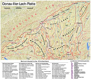
Eastern part: much of the landscape is wet or boggy; mainly open landscape with meadows and pastures
1354:
592:
Rapid alternation of open country (more grassland than arable land) and wooded areas (pine forests)
16:
621:
Comprises various old gravel terraces along the valleys of the Riss and Danube, formed during the
531:
1093:
1069:
138:
1459:
1318:
1197:
1065:
1009:
983:
Boundary between the
Stauden Plateau and Zusam Plateau and Stauffenberg region: Thannhausen –
883:
850:
521:
Western part: arable land dominates due to the covering of loess, grassland in the wet valleys
240:
123:
947:
1131:
Intensive agricultural land use (in the south more grassland, in the north more arable land)
1089:
134:
589:
Mostly loam and loess covered, ridges however loam-free, decalcified and therefore forested
1521:
1430:
1409:
1207:
1169:
In the south dominated by Riss Ice Age morainic material, that covers the
Tertiary bedrock
1103:
622:
498:
454:
275:
202:
169:
80:
48:
857:
752:
312:
1402:
1082:
892:
Boundary roughly between the Upper and Lower Iller-Lech Gravel
Plateaus: Babenhausen –
1264:
Eastern boundary: parallel to state road 2035 (Augsburg-Pöttmes-Neuburg by the Danube)
1510:
745:
690:
541:
466:
316:
298:
1450:
Kutt Schrem (2004), Gesellschaft
Oberschwaben für Geschichte und Kultur e.V. (ed.),
1433:
and the information pages of the individual sub-divisions of the Iller-Lech
Plateau
502:
476:
308:
294:
283:
111:
76:
213:
1088:
Boundary lies roughly between the Upper and Lower Lech-Wertach Plain: Türkheim –
988:
966:
875:
861:
838:
827:
555:
470:
375:
225:
217:
149:
The sub-divisions are based upon the natural regions of
Germany as shown on the
24:
1329:
1076:
893:
879:
771:
355:
119:
103:
1492:
1479:
1032:
The
Stauden Plateau, Zusam Plateau and Stauffenberg region together form the
998:
977:
823:
731:
686:
672:
236:
29:
433:
Agricultural land use predominates because the soils are loamy and fertile
261:
Alternation of open landscape in valleys and forested ridges (pine forests)
1142:
1059:
984:
973:
962:
922:
River valleys: in the north more arable land, in the south more grassland
871:
831:
559:
344:
229:
99:
1423:
1138:
There are only a few remnants of the formerly widespread heath landscape
162:
102:
its eastern boundary runs roughly parallel to state road 2035 (Augsburg-
1107:
1047:
930:
887:
819:
714:
The north is used more for arable farming; the south more as grassland
702:
701:
Broad valley filled by large quantities of gravel during and after the
694:
613:
482:
221:
321:
Beyond this gap the Danube flows through a scoured basin of reed marsh
1394:
1325:
1314:
867:
551:
439:
115:
84:
1002:
914:
568:
486:
307:
From Mengen to the narrow gap by the southernmost outliers of the
23:
567:
Part of the ice-age formed terraced landscape between Riss and
389:
On the silted-up areas there is extensive pastureland in places
367:) from the Riss glaciation with the extensive silted-up areas (
1415:
1166:
Dominated by the high terrace gravels of the Lech in the north
1141:
Together the Upper and the Lower Lech-Wertach Plains form the
741:
279:
258:) in the valleys to great depth, hence meadow and pasture land
150:
837:
Western boundary: Iller or Günz Valley in places (Neu-Ulm –
354:
The
Federsee lies in the middle of this natural region near
79:(unit D60 on the map) and, in the extreme northeast, on the
1200:
to Augsburg and from Augsburg to where it joins the Danube
1277:
Divided by deep stream valley that are mostly asymmetrical
919:
Interfluvials: Covered by forest (especially pine forests)
723:
In places, continuous alluvial forest, in places still bog
1245:
Almost continuous belt of alluvial forest along the river
1452:
Pfullendorff, ein Reichs-Statt in Ober-Schwaben gelegen
1235:
The further north, the more arable farming predominates
75:
In the northwest the Iller-Lech Plateau borders on the
636:
The south is less dissected by valleys than the north
510:
Riss glaciation terminal or ground moraine landscape
293:
Danube Valley between Mengen and Ulm, region between
1403:
http://www.geodaten.bayern.de/BayernViewer/index.cgi
1005:
into gently undulating plateaus and flat interfluves
1102:Divided into lower terrace landscape by the Rivers
644:
Sub-divisions in both Baden-Württemberg and Bavaria
1206:Extensive deposits of post-glacial gravel between
90:In the east the Iller-Lech Plateau borders on the
1401:Bayernviewer at the Bavarian Measurement Office:
1008:Numerous bogs on the valley floors of the partly
423:, in places however also ice age gravel deposits
1220:Meadows and lower terraces waterlogged in places
969:) and the Lech and/or Wertach Valley in the east
497:Boundary between the Western and Eastern Riss-
1160:Between Gennach and Lech, south of Denklingen
965:Valley in the west (Offingen, Thannhausen and
412:Region between Danube, Riss and, roughly, the
311:the floor of the Danube Valley is filled with
1112:Meadows and lower terraces partly waterlogged
374:In the south the silted-up areas give way to
8:
1274:High gravel plateau, rising towards the east
1180:Pure forest landscape (mainly pine forests)
1232:On the upper terrace chiefly arable farming
534:is in the east of the Riss-Aitrach Plateau
39:The Sub-divisions of the Iller-Lech Plateau
1464:: CS1 maint: location missing publisher (
1213:North of Augsburg: broad U-shaped valley (
1292:Valley floors mainly covered by grassland
1026:Pine forests dominated the woodland areas
1303:
1251:
1187:
1151:
1040:
942:
804:
784:
744:plain by the Danube between Neu-Ulm and
729:
667:
647:
603:
539:
447:
403:
342:
272:
199:
179:
34:
15:
1442:
669:Higher Plains of the Lower Iller Valley
254:Decalcified, waterlogged, brown earth (
1457:
677:Lower Plains of the Lower Iller Valley
1424:http://www.bfn.de/geoinfo/landscapes/
1338:Landscape rising from north to south
1034:Augsburg-Westliche Wälder Nature Park
952:Zusam Plateau and Stauffenberg Region
163:http://www.bfn.de/geoinfo/landscapes/
7:
929:Gravel extraction in the Mindel and
239:landscape dominated by the Rift and
856:Southern boundary: Dietmannsried –
598:Landscape still not very dissected
491:Southern boundary: Bad forestsee –
475:Northern boundary: Schemmerhofen –
20:The Iller-Lech Plateau (region D64)
1295:Otherwise arable land predominates
1210:and the confluence with the Danube
1153:Sachsenried and Denklingen Rotwald
913:Glacial gravels partly covered by
755:formed, partly boggy gravel plain
332:Much grassland and arable farming
297:and Bad Saulgau, Riss Valley from
176:Sub-divisions in Baden-Württemberg
14:
481:Eastern boundary: Ochsenhausen –
110:), south of Augsburg east of the
98:(unit D65 on the map). North of
1267:Northern boundary: Danube Valley
810:Lower Iller-Lech Gravel Plateaus
693:to where it joins the Danube at
1081:Eastern boundary: Denklingen –
605:Eastern Plain of the Lower Riss
405:Western Plain of the Lower Riss
818:Northern boundary: Donauried (
1:
1261:Western boundary: Lech Valley
1075:Southern boundary: Pforzen –
1010:asymmetrically shaped valleys
573:Divided by numerous hollows (
301:to where it joins the Danube
1532:Regions of Baden-Württemberg
1064:Western boundary: Pforzen –
954:(Reischenau and Holzwinkel)
248:Gently rolling hill country
28:Bird habitat in the eastern
1128:are covered by pine forests
1553:
1537:Natural regions of Germany
1385:Natural regions of Germany
1371:Natural regions of Germany
1309:
1257:
1193:
1157:
1054:
957:
814:
737:
682:
631:Intensive arable land use
609:
547:
461:
409:
351:
290:
264:On good soils: arable land
209:
65:natural regions of Germany
1348:Arable land predominates
997:Region is divided by the
936:Fens were largely drained
61:Oberschwäbische Hochebene
1390:Bavarian Alpine Foreland
1229:Mostly used as grassland
1058:Northern boundary: near
781:Sub-divisions in Bavaria
501:Plateaus: Bad Waldsee -
131:Southern Alpine Foreland
96:Isar-Inn Gravel Plateaus
577:) and meltwater troughs
212:Region between Danube,
53:Donau-Iller-Lech-Platte
616:, Senden and Laupheim
363:Former tongue-basins (
274:Danube Valley between
52:
40:
32:
21:
1454:(in German), Tettnang
1420:Landscapes in Germany
843:Kellmünz an der Iller
788:Geographical location
679:(north of Memmingen)
651:Geographical location
421:Tertiary Hill Country
243:of the Rhine Glacier
183:Geographical location
159:Landscapes in Germany
155:Landscapes in Germany
92:Lower Bavarian Upland
57:Upper Swabian Plateau
55:), also known as the
38:
27:
19:
1527:Geography of Bavaria
1289:Thick layer of loess
108:Neuburg an der Donau
1493:48.2431°N 10.3633°E
1489: /
972:Northern boundary:
961:Between Mindel and
558:, Ochsenhausen and
493:Leutkirch im Allgäu
369:Verlandungsgebieten
1517:Iller-Lech Plateau
1429:2016-03-03 at the
1408:2009-03-27 at the
1353:Together with the
1343:Gently undulating
1324:Eastern boundary:
1313:Western boundary:
1253:Aindlingen Terrace
1017:Gently undulating
907:Gently undulating
866:Eastern boundary:
685:Iller Valley from
465:Western boundary:
442:is in this region
168:2016-03-03 at the
114:, roughly between
45:Iller-Lech Plateau
41:
33:
22:
1362:
1361:
1319:Landsberg am Lech
1305:Landsberg Plateau
1196:Lech Valley from
778:
777:
641:
640:
315:gravels from the
241:Mindel glaciation
135:terminal moraines
129:To the south the
63:), is one of the
1544:
1504:
1503:
1501:
1500:
1499:
1498:48.2431; 10.3633
1494:
1490:
1487:
1486:
1485:
1482:
1470:
1469:
1463:
1455:
1447:
1355:Fürstenfeldbruck
785:
648:
180:
1552:
1551:
1547:
1546:
1545:
1543:
1542:
1541:
1507:
1506:
1497:
1495:
1491:
1488:
1483:
1480:
1478:
1476:
1475:
1473:
1456:
1449:
1448:
1444:
1440:
1431:Wayback Machine
1410:Wayback Machine
1379:
1367:
1208:Klosterlechfeld
944:Stauden Plateau
797:Soil / Land use
783:
660:Soil / Land use
646:
623:Riss glaciation
612:Region between
550:Region between
192:Soil / Land use
178:
170:Wayback Machine
147:
139:Würm glaciation
81:Franconian Jura
73:
12:
11:
5:
1550:
1548:
1540:
1539:
1534:
1529:
1524:
1519:
1509:
1508:
1472:
1471:
1441:
1439:
1436:
1435:
1434:
1412:
1399:
1398:
1397:
1392:
1387:
1378:
1375:
1374:
1373:
1366:
1363:
1360:
1359:
1350:
1345:
1340:
1335:
1334:
1333:
1332:– Fuchs Valley
1322:
1321:– Fuchs Valley
1308:
1307:
1301:
1300:
1298:
1297:
1296:
1293:
1290:
1285:
1280:
1279:
1278:
1275:
1270:
1269:
1268:
1265:
1262:
1256:
1255:
1249:
1248:
1247:
1246:
1243:
1238:
1237:
1236:
1233:
1230:
1225:
1223:
1222:
1221:
1218:
1211:
1202:
1192:
1191:
1185:
1184:
1182:
1177:
1175:Flat to hilly
1172:
1171:
1170:
1167:
1162:
1156:
1155:
1149:
1148:
1147:
1146:
1145:(Lech Plateau)
1139:
1134:
1133:
1132:
1129:
1120:
1115:
1114:
1113:
1110:
1098:
1097:
1096:
1086:
1083:Untermeitingen
1079:
1073:
1066:Bad Wörishofen
1062:
1053:
1052:
1038:
1037:
1029:
1028:
1027:
1024:
1019:
1014:
1013:
1012:
1006:
993:
992:
991:
981:
980:– Buttenwiesen
970:
956:
955:
940:
939:
938:
937:
934:
925:
924:
923:
920:
917:
909:
904:
899:
898:
897:
890:
884:Bad Wörishofen
864:
854:
851:Bad Grönenbach
835:
813:
812:
802:
801:
798:
795:
792:
789:
782:
779:
776:
775:
767:
762:
757:
749:
736:
735:
727:
726:
725:
724:
721:
716:
711:
706:
698:
681:
680:
665:
664:
661:
658:
655:
652:
645:
642:
639:
638:
633:
628:
626:
618:
608:
607:
601:
600:
595:
594:
593:
590:
585:
583:Rolling hills
580:
579:
578:
571:
563:
546:
545:
537:
536:
527:
526:
525:
522:
517:
512:
507:
506:
505:
495:
489:
479:
473:
460:
459:
445:
444:
435:
430:
425:
417:
408:
407:
401:
400:
395:
394:
393:
390:
385:
380:
379:
378:
372:
359:
350:
349:
340:
339:
334:
329:
324:
323:
322:
319:
303:
289:
288:
270:
269:
267:
266:
265:
262:
259:
250:
245:
233:
208:
207:
197:
196:
193:
190:
187:
184:
177:
174:
146:
143:
72:
69:
13:
10:
9:
6:
4:
3:
2:
1549:
1538:
1535:
1533:
1530:
1528:
1525:
1523:
1520:
1518:
1515:
1514:
1512:
1505:
1502:
1467:
1461:
1453:
1446:
1443:
1437:
1432:
1428:
1425:
1421:
1417:
1413:
1411:
1407:
1404:
1400:
1396:
1393:
1391:
1388:
1386:
1383:
1382:
1381:
1380:
1376:
1372:
1369:
1368:
1364:
1358:
1356:
1351:
1349:
1346:
1344:
1341:
1339:
1336:
1331:
1327:
1323:
1320:
1316:
1312:
1311:
1310:
1306:
1302:
1299:
1294:
1291:
1288:
1287:
1286:
1284:
1281:
1276:
1273:
1272:
1271:
1266:
1263:
1260:
1259:
1258:
1254:
1250:
1244:
1241:
1240:
1239:
1234:
1231:
1228:
1227:
1226:
1224:
1219:
1216:
1212:
1209:
1205:
1204:
1203:
1201:
1199:
1194:
1190:
1186:
1183:
1181:
1178:
1176:
1173:
1168:
1165:
1164:
1163:
1161:
1158:
1154:
1150:
1144:
1140:
1137:
1136:
1135:
1130:
1127:
1123:
1122:
1121:
1119:
1116:
1111:
1109:
1105:
1101:
1100:
1099:
1095:
1091:
1090:Schwabmünchen
1087:
1084:
1080:
1078:
1074:
1071:
1067:
1063:
1061:
1057:
1056:
1055:
1051:
1049:
1043:
1039:
1036:
1035:
1030:
1025:
1022:
1021:
1020:
1018:
1015:
1011:
1007:
1004:
1000:
996:
995:
994:
990:
986:
982:
979:
976:– Holzheim –
975:
971:
968:
964:
960:
959:
958:
953:
949:
945:
941:
935:
932:
928:
927:
926:
921:
918:
916:
912:
911:
910:
908:
905:
903:
900:
895:
891:
889:
885:
881:
877:
873:
869:
865:
863:
859:
855:
852:
848:
844:
840:
836:
833:
829:
825:
821:
817:
816:
815:
811:
807:
803:
799:
796:
793:
790:
787:
786:
780:
774:
773:
768:
766:
763:
761:
758:
756:
754:
750:
748:
747:
743:
738:
734:
733:
728:
722:
719:
718:
717:
715:
712:
710:
707:
705:
704:
699:
697:
696:
692:
691:Dietmannsried
688:
683:
678:
674:
670:
666:
662:
659:
656:
653:
650:
649:
643:
637:
634:
632:
629:
627:
625:
624:
619:
617:
615:
610:
606:
602:
599:
596:
591:
588:
587:
586:
584:
581:
576:
572:
570:
566:
565:
564:
562:
561:
557:
553:
548:
544:
543:
538:
535:
533:
528:
523:
520:
519:
518:
516:
513:
511:
508:
504:
500:
496:
494:
490:
488:
484:
480:
478:
474:
472:
469:– Federsee –
468:
467:Schemmerhofen
464:
463:
462:
458:
456:
453:Eastern Riss-
450:
446:
443:
441:
436:
434:
431:
429:
426:
424:
422:
418:
416:
415:
410:
406:
402:
399:
396:
391:
388:
387:
386:
384:
381:
377:
373:
370:
366:
365:central basin
362:
361:
360:
358:
357:
352:
348:
346:
341:
338:
335:
333:
330:
328:
325:
320:
318:
317:Rhine Glacier
314:
310:
306:
305:
304:
302:
300:
299:Schemmerhofen
296:
291:
287:
285:
281:
277:
271:
268:
263:
260:
257:
256:Parabraunerde
253:
252:
251:
249:
246:
244:
242:
238:
234:
232:
231:
227:
223:
219:
215:
210:
206:
204:
198:
194:
191:
188:
185:
182:
181:
175:
173:
171:
167:
164:
160:
156:
152:
145:Sub-divisions
144:
142:
140:
136:
132:
127:
125:
121:
117:
113:
109:
105:
101:
97:
93:
88:
86:
82:
78:
70:
68:
66:
62:
58:
54:
50:
46:
37:
31:
26:
18:
1474:
1451:
1445:
1419:
1352:
1347:
1342:
1337:
1304:
1282:
1252:
1214:
1195:
1188:
1179:
1174:
1159:
1152:
1125:
1117:
1045:
1041:
1031:
1016:
951:
943:
906:
901:
896:– Markt Wald
858:Obergünzburg
809:
805:
769:
764:
759:
753:Würm Ice Age
751:
739:
730:
713:
708:
700:
684:
676:
668:
635:
630:
620:
611:
604:
597:
582:
574:
549:
540:
532:Wurzach Ried
529:
514:
509:
503:Eberhardzell
477:Ochsenhausen
452:
448:
437:
432:
427:
419:
411:
404:
397:
382:
368:
364:
353:
343:
336:
331:
326:
313:Würm Ice Age
309:Swabian Jura
295:Herbertingen
292:
273:
255:
247:
235:
211:
200:
158:
154:
148:
128:
89:
77:Swabian Jura
74:
60:
56:
44:
42:
1496: /
1414:Map of the
1189:Lech Valley
1046:Upper Lech-
989:Stadtbergen
876:Thannhausen
862:Friesenried
847:Babenhausen
839:Illertissen
772:gravel pits
575:Muldentäler
556:Aichstetten
515:Undulating
471:Bad Waldsee
376:Young Drift
226:Bad Saulgau
218:Pfullendorf
1511:Categories
1484:10°21′48″E
1481:48°14′35″N
1438:References
1330:Geltendorf
1085:– Bobingen
1077:Denklingen
1072:– Bobingen
894:Mindelheim
880:Markt Wald
746:Donauwörth
671:(south of
542:Holzstöcke
356:Bad Buchau
120:Geltendorf
71:Boundaries
1215:Kastental
1094:Kaufering
1070:Rammingen
999:Schmutter
978:Wertingen
824:Nersingen
791:Formation
732:Donauried
687:Altusried
673:Memmingen
654:Formation
237:Old Drift
214:Mühlingen
186:Formation
30:Donauried
1460:citation
1427:Archived
1406:Archived
1365:See also
1198:Schongau
1143:Lechfeld
1060:Bobingen
985:Fischach
974:Offingen
967:Türkheim
963:Flossach
872:Offingen
870:between
832:Offingen
828:Günzburg
800:Remarks
703:ice ages
663:Remarks
560:Laupheim
457:Plateaus
449:Western
345:Federsee
282:, Lower
230:Federsee
205:Plateaus
195:Remarks
166:Archived
124:Schongau
100:Augsburg
1377:Sources
1126:Brennen
1108:Gennach
1104:Wertach
1048:Wertach
948:Stauden
933:Valleys
888:Pforzen
820:Neu-Ulm
695:Neu-Ulm
614:Neu-Ulm
499:Aitrach
483:Aitrach
455:Aitrach
222:Ostrach
201:Danube-
137:of the
104:Pöttmes
1522:Swabia
1395:Riedel
1326:Mering
1315:Mering
1283:Hilly
868:Mindel
794:Relief
740:Large
675:) and
657:Relief
552:Senden
440:Bussen
428:Hilly
286:Valley
276:Mengen
203:Ablach
189:Relief
116:Mering
85:Danube
49:German
1118:Flat
1050:Plain
1042:Lower
1003:Zusam
915:loess
806:Upper
770:Many
760:Flat
709:Flat
569:Iller
487:Legau
414:B 312
383:Flat
327:Flat
1466:link
1124:The
1106:and
1044:and
1001:and
950:) /
931:Günz
874:and
808:and
689:and
530:The
451:and
438:The
347:Ried
284:Riss
278:and
228:and
122:and
112:Lech
94:and
43:The
1418:'s
1416:BfN
742:fen
280:Ulm
153:'s
151:BfN
1513::
1462:}}
1458:{{
1422::
1328:–
1317:–
1092:-
1068:–
987:-
886:–
882:–
878:–
860:–
849:–
845:–
841:–
830:-
826:–
822:–
554:,
485:–
224:,
220:,
216:,
172:)
141:.
126:.
118:,
87:.
67:.
51::
1468:)
946:(
853:)
834:)
371:)
161:(
106:-
59:(
47:(
Text is available under the Creative Commons Attribution-ShareAlike License. Additional terms may apply.