493:
33:
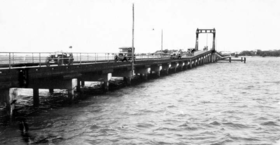
450:. The pedestrian crossing was 4 feet (1.2 m) wide and the road crossing was 13 feet 10 inches (4.22 m), sufficient for two cars to pass. The bridge rose in the middle to allow small boats to pass under it; a central span could be raised and lowered using a hand winch to allow larger vessels to pass, but the process took 25 minutes. The bridge cost approximately £23,000.
473:
declared the bridge open for vehicular traffic. On 28 November 1925, the town of
Southport was 50 years old. The day was declared a public holiday in Southport, the first of five days of jubilee celebrations. The first event on the day was another official opening of the Southport Bridge, this time
507:
due to its proximity to the
Sundale Shopping Centre, replaced the Jubilee Bridge, which was demolished. The bridge departs from a similar area of Southport but has a more north-south alignment and so reaches Main Beach further south than the Jubilee Bridge.
402:
362:
601:
307:
58:
352:. From that point, Meyer's ferry would take the travellers across the river to Meyer's Ferry Road at Elston (or the Main Surf Beach as it was then informally known, now
442:
The bridge was 19 feet (5.8 m) wide and built on reinforced concrete piles, mostly sunk down to a solid rock foundation. The superstructure was built from
558:
492:
766:
296:
In 1887, German immigrant Johann Meyer operated a ferry across the Nerang River. From
Southport, travellers would follow the Meyer's Ferry Road (now
593:
356:, Surfers Paradise). Although a popular destination, the lack of road access limited the extent of residential and commercial development.
32:
771:
458:
704:
761:
756:
751:
462:
51:
359:
In 1925, the
Southport Bridge (as it was initially known) was built as a direct extension of Queen Street, Southport (
562:
566:
731:
726:
721:
349:
297:
281:
277:
112:
273:
266:
38:
659:
631:
535:
475:
167:
399:) in an approximate east-west alignment connecting to what is now Main Beach Parade, Main Beach (
126:
470:
344:). The narrow spit is no longer in existence due to changes in the river and the creation of
285:
201:
682:
Potts, Andrew (7 January 2010). "Name lives on as a bridge to the past Sunset on
Sundale".
716:
504:
478:
466:
345:
136:
288:. It facilitated the development of the Gold Coast beach suburbs and holiday resorts.
745:
353:
301:
262:
102:
500:
In 1933, the lifting span was removed as large vessels no longer used the river.
465:. It could not be opened for vehicular traffic until the road from Main Beach to
447:
156:
454:
269:
116:
654:
626:
530:
418:
404:
378:
364:
323:
309:
74:
60:
453:
The bridge was officially opened for pedestrian traffic on 8 April 1925 by
486:
443:
152:
491:
485:
in honour of
Southport's 50th anniversary by smashing a bottle of
304:) to a spit of land that created a narrow point in the river (
503:
In 1966, the present Gold Coast Bridge, locally known as the
439:); at that time Main Beach was not developed as it is today.
663:. National Library of Australia. 2 November 1925. p. 13
635:. National Library of Australia. 27 November 1925. p. 7
539:. National Library of Australia. 9 April 1925. p. 8
246:
238:
223:
208:
197:
192:
184:
173:
162:
147:
142:
132:
122:
108:
98:
50:
23:
272:, Australia. The bridge connected the suburbs of
489:against one of the bridge's concrete abutments.
8:
621:
619:
525:
523:
521:
20:
496:Heavy traffic on the Jubilee Bridge, 1933
284:, providing the first road connection to
517:
604:from the original on 24 September 2015
469:was completed. On 29 August 1925, the
588:
586:
584:
7:
627:"JUBILEE BRIDGE. SOUTHPORT REJOICES"
261:(1925–1966) was a bridge across the
459:Member of the Legislative Assembly
14:
767:1925 establishments in Australia
31:
18:Bridge in Gold Coast, Queensland
348:but was in the vicinity of the
481:who christened the bridge the
1:
594:"Jubilee Bridge (South Side)"
430:Main Beach end of the bridge
732:GPX (secondary coordinates)
390:Southport end of the bridge
788:
563:City of Gold Coast Council
559:"Surfers Paradise history"
227:28 November 1925
772:Bridges completed in 1925
727:GPX (primary coordinates)
702:Map all coordinates using
655:"SOUTHPORT AND BEECHMONT"
251:
30:
710:Download coordinates as:
684:The Gold Coast Bulletin
180:1,300 feet (400 m)
127:Gold Coast City Council
762:Main Beach, Queensland
497:
350:Gold Coast Arts Centre
212:8 April 1925
757:Southport, Queensland
752:Bridges in Queensland
722:GPX (all coordinates)
495:
242:1966 (and demolished)
660:The Brisbane Courier
632:The Brisbane Courier
536:The Brisbane Courier
487:Australian champagne
419:27.9747°S 153.4253°E
379:27.9738°S 153.4199°E
324:28.0011°S 153.4247°E
188:19 feet (5.8 m)
75:27.9745°S 153.4227°E
476:Lieutenant Governor
414: /
374: /
319: /
168:Reinforced concrete
163:Trough construction
70: /
498:
471:Mayor of Southport
424:-27.9747; 153.4253
384:-27.9738; 153.4199
329:-28.0011; 153.4247
80:-27.9745; 153.4227
255:
254:
198:Construction cost
779:
688:
687:
679:
673:
672:
670:
668:
651:
645:
644:
642:
640:
623:
614:
613:
611:
609:
590:
579:
578:
576:
574:
565:. Archived from
555:
549:
548:
546:
544:
527:
438:
437:
435:
434:
433:
431:
426:
425:
420:
415:
412:
411:
410:
407:
398:
397:
395:
394:
393:
391:
386:
385:
380:
375:
372:
371:
370:
367:
343:
342:
340:
339:
338:
336:
331:
330:
325:
320:
317:
316:
315:
312:
286:Surfers Paradise
234:
232:
219:
217:
94:
93:
91:
90:
89:
87:
82:
81:
76:
71:
68:
67:
66:
63:
37:Jubilee Bridge,
35:
21:
787:
786:
782:
781:
780:
778:
777:
776:
742:
741:
740:
739:
738:
737:
736:
697:
692:
691:
681:
680:
676:
666:
664:
653:
652:
648:
638:
636:
625:
624:
617:
607:
605:
592:
591:
582:
572:
570:
557:
556:
552:
542:
540:
531:"BRIDGE OPENED"
529:
528:
519:
514:
429:
427:
423:
421:
417:
416:
413:
408:
405:
403:
401:
400:
389:
387:
383:
381:
377:
376:
373:
368:
365:
363:
361:
360:
334:
332:
328:
326:
322:
321:
318:
313:
310:
308:
306:
305:
294:
230:
228:
215:
213:
143:Characteristics
85:
83:
79:
77:
73:
72:
69:
64:
61:
59:
57:
56:
46:
26:
19:
12:
11:
5:
785:
783:
775:
774:
769:
764:
759:
754:
744:
743:
735:
734:
729:
724:
719:
713:
707:
700:
699:
698:
696:
695:External links
693:
690:
689:
674:
646:
615:
580:
569:on 4 June 2016
550:
516:
515:
513:
510:
505:Sundale Bridge
483:Jubilee Bridge
479:William Lennon
467:Burleigh Heads
346:Chevron Island
293:
290:
259:Jubilee Bridge
253:
252:
249:
248:
244:
243:
240:
236:
235:
225:
221:
220:
210:
206:
205:
199:
195:
194:
190:
189:
186:
182:
181:
175:
171:
170:
164:
160:
159:
149:
145:
144:
140:
139:
137:Sundale Bridge
134:
130:
129:
124:
120:
119:
110:
106:
105:
100:
96:
95:
86:Jubilee Bridge
54:
48:
47:
36:
28:
27:
25:Jubilee Bridge
24:
17:
13:
10:
9:
6:
4:
3:
2:
784:
773:
770:
768:
765:
763:
760:
758:
755:
753:
750:
749:
747:
733:
730:
728:
725:
723:
720:
718:
715:
714:
712:
711:
706:
705:OpenStreetMap
703:
694:
685:
678:
675:
662:
661:
656:
650:
647:
634:
633:
628:
622:
620:
616:
603:
599:
595:
589:
587:
585:
581:
568:
564:
560:
554:
551:
538:
537:
532:
526:
524:
522:
518:
511:
509:
506:
501:
494:
490:
488:
484:
480:
477:
472:
468:
464:
460:
456:
451:
449:
445:
440:
436:
396:
357:
355:
354:Cavill Avenue
351:
347:
341:
335:Meyer's Ferry
303:
299:
291:
289:
287:
283:
279:
275:
271:
268:
264:
260:
250:
245:
241:
237:
226:
222:
211:
207:
203:
200:
196:
191:
187:
183:
179:
176:
172:
169:
165:
161:
158:
154:
150:
146:
141:
138:
135:
131:
128:
125:
121:
118:
114:
111:
107:
104:
101:
97:
92:
55:
53:
49:
44:
40:
34:
29:
22:
16:
709:
708:
701:
683:
677:
665:. Retrieved
658:
649:
637:. Retrieved
630:
606:. Retrieved
597:
571:. Retrieved
567:the original
553:
541:. Retrieved
534:
502:
499:
482:
452:
441:
358:
302:Bundall Road
295:
263:Nerang River
258:
256:
177:
174:Total length
103:Nerang River
42:
15:
448:spotted gum
422: /
409:153°25′31″E
382: /
369:153°25′12″E
327: /
314:153°25′29″E
224:Inaugurated
157:spotted gum
133:Followed by
78: /
65:153°25′22″E
52:Coordinates
746:Categories
667:15 January
639:15 January
608:15 January
598:Geocaching
573:15 January
543:15 January
512:References
455:John Appel
428: (
406:27°58′29″S
388: (
366:27°58′26″S
333: (
311:28°00′04″S
298:Ferry Road
282:Gold Coast
278:Main Beach
270:Queensland
267:South East
231:1925-11-28
216:1925-04-08
117:Queensland
113:Gold Coast
84: (
62:27°58′28″S
274:Southport
39:Southport
602:Archived
444:ironbark
247:Location
153:Ironbark
148:Material
292:History
280:on the
229: (
214: (
193:History
166:Piers:
99:Crosses
463:Albert
239:Closed
209:Opened
204:23,000
151:Deck:
109:Locale
185:Width
178:circa
123:Owner
43:circa
669:2015
641:2015
610:2015
575:2015
545:2015
461:for
446:and
300:and
257:The
155:and
45:1932
717:KML
474:by
276:to
265:in
748::
657:.
629:.
618:^
600:.
596:.
583:^
561:.
533:.
520:^
457:,
115:,
41:,
686:.
671:.
643:.
612:.
577:.
547:.
432:)
392:)
337:)
233:)
218:)
202:£
88:)
Text is available under the Creative Commons Attribution-ShareAlike License. Additional terms may apply.