2492:
280:
197:
2504:
2468:
20:
2480:
144:. The annual mean temperature is −25 °C (−13 °F), with the summer temperature able to reach about 0 °C (32 °F) and the lowest during the winter at −50 °C (−58 °F). Storms, which can occur throughout the year, can occasionally make outdoor activity impossible. Being located south of the
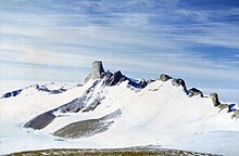
90:. The main ice-free area of the Jutulsessen massif is about 10 km long by 5 km across. The base is located 1,270 meters (4,170 ft) above mean sea level and is completely surrounded by the Antarctic ice sheet. Jutulsessen is 235 kilometers (146 mi) from the coast of King Haakon VII Sea.
179:
in 1950. It was located on ice and used only during the summer. After a few years, it was so covered in snow that it was not possible to dig out. When searching for a new station, the
Norwegian Polar Institute decided to find an area which would be snow-free in January and February and which was
188:. The area was explored by helicopter on January 11, 1990, and the expedition decided to establish a base on the lower parts of Jutulessen. Troll was officially opened on February 17, 1990. Troll Airfield was opened on February 11, 2005 and an all-year research station the following day.
2435:
929:
225:
169:
1844:
232:. The facilities consist of a module-built new section that is 300 square meters (3,200 sq ft), and the old section that is 100 square meters (1,100 sq ft).
1516:
105:
to the north. The two arms of the area are located northwards. The western arm is the location of Troll. The eastern arm is longer and consists of the narrow section of
922:
86:, also in the Gjelsvik Mountains of Queen Maud Land. Jutulsessen is located in the eastern part of Princess Martha Coast in Queen Maud Land, which Norway claims as a
1644:
715:
2524:
915:
2247:
2207:
2192:
2122:
172:
in 1949–52 and the subsequent
Norwegian expedition in 1958–59. It was given the Norwegian name Jutulsessen, which means "the seat of the giant".
125:, a ridge of Armlenet. Jutuldalen is a valley in Armlenet, with the ice-depression of Staupet to the west. Armlenet also features the glacier of
2127:
2097:
2047:
2534:
2237:
2147:
2092:
2004:
866:
847:
698:
428:
2087:
1695:
749:
244:
330:
2365:
1125:
809:
264:
2549:
1566:
397:
2539:
805:
775:
745:
634:
2544:
1984:
1268:
279:
753:
1849:
1243:
779:
248:
2162:
1720:
1586:
1556:
688:
168:
in 1938–39. It was subsequently mapped by
Norwegian cartographers from surveys and air photographs taken during the
2458:
1969:
1334:
1258:
723:
366:
2529:
1488:
1193:
1170:
612:
587:
562:
537:
512:
487:
462:
432:
401:
229:
236:
is located 6.8 kilometres (4.2 mi) from Troll and consists of a 3,300-by-100-metre (10,830 by 330 ft)
1654:
1440:
458:
326:
256:
207:
200:
106:
55:
1799:
1445:
1407:
1180:
1051:
1046:
1041:
878:
252:
83:
59:
2039:
998:
988:
292:
2496:
2320:
1056:
47:
1864:
436:
196:
2370:
2277:
1664:
1591:
1301:
947:
221:
126:
79:
558:
2503:
2330:
1944:
1929:
1107:
938:
288:
87:
51:
813:
1601:
1483:
181:
130:
35:
1804:
1354:
118:
2415:
2360:
2345:
2335:
2197:
2137:
2014:
1999:
1949:
1859:
1450:
1435:
862:
843:
694:
122:
2484:
2440:
2385:
2232:
2222:
2152:
2024:
2009:
1989:
1854:
1753:
1748:
1725:
1690:
1561:
1208:
1160:
1026:
983:
533:
304:
296:
176:
145:
134:
2445:
2430:
2400:
2380:
2355:
2285:
2227:
2212:
2132:
2072:
1914:
1776:
1715:
1705:
1682:
1624:
1596:
1541:
1478:
1460:
1402:
1364:
1339:
1288:
1263:
1155:
1150:
1115:
1008:
973:
268:
260:
217:
137:. The three peaks closest to Troll are Trolltindane, the tallest of which is Trolltinden.
39:
2508:
2375:
2325:
2305:
2290:
2267:
2172:
2142:
2112:
2057:
2029:
2019:
1939:
1924:
1919:
1909:
1894:
1869:
1839:
1809:
1740:
1649:
1639:
1629:
1576:
1551:
1511:
1397:
1387:
1379:
1369:
1344:
1329:
1296:
1278:
1273:
1218:
1165:
1145:
1130:
1120:
1074:
1021:
993:
955:
233:
67:
243:
Research facilities include air and atmospheric measurement equipment operated by the
2518:
2395:
2295:
2252:
2242:
2167:
2157:
2102:
2067:
2052:
1994:
1974:
1954:
1884:
1781:
1571:
1546:
1536:
1503:
1493:
1455:
1417:
1359:
1319:
1253:
1135:
978:
907:
405:
287:
A 500 ha site some 6 km south-east of Troll
Station has been designated an
638:
2472:
2425:
2420:
2410:
2405:
2340:
2310:
2262:
2217:
2182:
2117:
2107:
1964:
1959:
1899:
1889:
1879:
1874:
1834:
1824:
1819:
1814:
1730:
1710:
1700:
1672:
1634:
1425:
1324:
1248:
1233:
1228:
1213:
1140:
1079:
1066:
1016:
583:
149:
508:
2315:
2300:
2202:
2187:
2077:
1979:
1829:
1791:
1771:
1763:
1606:
1581:
1430:
1349:
1311:
1238:
1203:
1198:
1036:
300:
212:
The station took its name from the surrounding jagged mountains, which resemble
153:
483:
2390:
2350:
2257:
2177:
2082:
2062:
1904:
1531:
1521:
1470:
1392:
1223:
1188:
1097:
965:
608:
165:
43:
893:
880:
1526:
1089:
783:
78:
Jutulsessen is a nunatak mountain with a peak 2,370 meters (7,780 ft)
1934:
1616:
185:
110:
102:
295:, because it supports a large breeding colony of about 38,000 pairs of
114:
94:
31:
19:
237:
141:
98:
63:
278:
213:
195:
18:
23:
View of the north-western part of
Jutulsessen from the south-east
911:
54:. Jutulsessen is the site of the Norwegian research station
226:
Norwegian
Directorate of Public Construction and Property
140:
The area has a cold and dry climate being located in a
2456:
82:. It is located 13 kilometers (8.1 mi) north of
2276:
2038:
1790:
1762:
1739:
1681:
1663:
1615:
1502:
1469:
1416:
1378:
1310:
1287:
1179:
1106:
1088:
1065:
1007:
964:
946:
228:. Operation of the facility is carried out by the
175:Norway established the Antarctic polar station
170:Norwegian–British–Swedish Antarctic Expedition
129:. Southeast of Sætet lies the broad valley of
923:
93:The mountain area is horseshoe-shaped with a
8:
693:(4th ed.). Lonely Planet. p. 305.
121:is an ice-depression on the western side of
164:The mountain was first photographed by the
930:
916:
908:
716:"New Norwegian air field in the Antarctic"
220:. The station facilities are owned by the
113:. Further north lies the isolated area of
299:on north-facing slopes in the mountains.
184:that would allow the establishment of an
133:, and to the southeast lies the ridge of
842:(in Norwegian). Oslo: Schibsted Forlag.
50:, 235 kilometers (146 mi) from the
2463:
315:
349:
347:
321:
319:
392:
390:
388:
361:
359:
7:
750:Norwegian Institute for Air Research
714:Solholm, Rolleiv (1 February 2003).
245:Norwegian Institute for Air Research
331:Geographic Names Information System
2525:Important Bird Areas of Antarctica
810:Norwegian Meteorological Institute
746:"Antarktis: Troll får nye krefter"
283:Antarctic petrels breed in the IBA
265:Norwegian Meteorological Institute
14:
2502:
2490:
2478:
2466:
1517:Blue Glacier to Cape Chocolate
373:. BirdLife International. 2015
1:
2535:Mountains of Queen Maud Land
780:Kongsberg Satellite Services
398:"Troll i ord - ord om Troll"
307:also breed in the vicinity.
249:Kongsberg Satellite Services
70:is located in the vicinity.
861:(in Norwegian). Oslo: Pax.
166:German Antarctic Expedition
2566:
838:Kyvik, Helga, ed. (2008).
205:
1645:Franklin Island southwest
613:Norwegian Polar Institute
588:Norwegian Polar Institute
563:Norwegian Polar Institute
538:Norwegian Polar Institute
513:Norwegian Polar Institute
488:Norwegian Polar Institute
463:Norwegian Polar Institute
433:Norwegian Polar Institute
402:Norwegian Polar Institute
230:Norwegian Polar Institute
2550:Troll (research station)
1441:Greater Mackellar Island
259:providing research from
257:satellite ground station
208:Troll (research station)
66:on top of the mountain.
1446:Lesser Mackellar Island
1181:Princess Elizabeth Land
1052:Riiser-Larsen Peninsula
1047:Riiser-Larsen Ice Shelf
1042:Princess Ragnhild Coast
253:Troll Satellite Station
60:Troll Satellite Station
2540:Nunataks of Antarctica
2436:Southern Powell Island
2040:South Shetland Islands
999:Stancomb-Wills Glacier
989:Dawson-Lambton Glacier
857:Wormdal, Bård (2011).
429:"Jutulsessens geologi"
367:"Jutulsessen Mountain"
327:"Jutulsessen Mountain"
293:BirdLife International
284:
203:
24:
16:Mountain of Antarctica
2545:Princess Martha Coast
2321:Christoffersen Island
1057:Svarthamaren Mountain
776:"TrollSat/Antarctica"
282:
240:on glacial blue ice.
199:
48:Princess Martha Coast
22:
2371:Inaccessible Islands
2278:South Orkney Islands
1665:King Edward VII Land
1592:Inexpressible Island
1408:Géologie Archipelago
1302:Shackleton Ice Shelf
948:Queen Elizabeth Land
939:Important Bird Areas
687:Rubin, Jeff (2008).
222:Government of Norway
80:above mean sea level
2331:Ferguslie Peninsula
2123:East of Nelly Point
1945:Lagotellerie Island
1567:Duke of York Island
1108:Mac. Robertson Land
890: /
659:Wormdal (2011): 108
439:on 23 February 2013
289:Important Bird Area
275:Important Bird Area
267:operates a staffed
156:during the winter.
88:dependent territory
58:and the affiliated
52:King Haakon VII Sea
46:. It is located in
2128:Eastern Litwin Bay
1865:D'Urville Monument
1602:Possession Islands
1484:Kartografov Island
371:BirdLife Data Zone
285:
204:
152:in the summer and
36:Gjelsvik Mountains
25:
2454:
2453:
2416:Robertson Islands
2361:Graptolite Island
2346:Fredriksen Island
2336:Ferrier Peninsula
2138:False Round Point
2015:Stonington Island
2005:Ryder Bay Islands
2000:Rosenthal Islands
1950:Litchfield Island
1860:Cuverville Island
1451:Mackellar Islands
1436:Cape-Pigeon Rocks
1269:Waterhouse Island
868:978-82-530-3450-8
849:978-82-516-2589-0
840:Norge i Antarktis
700:978-1-74104-549-9
677:Kyvik (2008): 155
668:Kyvik (2008): 169
633:Hustadnes, John.
559:"Ringfingerbreen"
353:Kyvik (2008): 153
305:south polar skuas
297:Antarctic petrels
2557:
2530:Seabird colonies
2507:
2506:
2495:
2494:
2493:
2483:
2482:
2481:
2471:
2470:
2469:
2462:
2441:Watson Peninsula
2386:Michelsen Island
2248:Sugarloaf Island
2233:Saddleback Point
2223:Potter Peninsula
2153:Half Moon Island
2025:Tupinier Islands
2010:Snow Hill Island
1990:Petermann Island
1930:Guépratte Island
1855:Cormorant Island
1754:Sikorski Glacier
1749:Schaefer Islands
1726:Thurston Glacier
1691:Brownson Islands
1562:Downshire Cliffs
1209:Donskiye Islands
1161:Scullin Monolith
1027:Gruber Mountains
984:Stewart Buttress
932:
925:
918:
909:
905:
904:
902:
901:
900:
895:
894:72.033°S 2.683°E
891:
888:
887:
886:
883:
872:
853:
826:
825:
823:
821:
812:. Archived from
802:
796:
795:
793:
791:
782:. Archived from
772:
766:
765:
763:
761:
752:. Archived from
742:
736:
735:
733:
731:
726:on 7 August 2011
722:. Archived from
711:
705:
704:
684:
678:
675:
669:
666:
660:
657:
651:
650:
648:
646:
637:. Archived from
630:
624:
623:
621:
619:
605:
599:
598:
596:
594:
580:
574:
573:
571:
569:
555:
549:
548:
546:
544:
530:
524:
523:
521:
519:
505:
499:
498:
496:
494:
480:
474:
473:
471:
469:
455:
449:
448:
446:
444:
435:. Archived from
431:(in Norwegian).
424:
418:
417:
415:
413:
404:. Archived from
400:(in Norwegian).
394:
383:
382:
380:
378:
363:
354:
351:
342:
341:
339:
337:
323:
263:satellites. The
146:Antarctic Circle
62:, which has two
2565:
2564:
2560:
2559:
2558:
2556:
2555:
2554:
2515:
2514:
2513:
2501:
2491:
2489:
2479:
2477:
2467:
2465:
2457:
2455:
2450:
2446:Weddell Islands
2431:Skilling Island
2401:Pirie Peninsula
2381:Matthews Island
2356:Gosling Islands
2286:Atriceps Island
2272:
2228:Pottinger Point
2213:Point Hennequin
2133:Escarpada Point
2073:Byers Peninsula
2034:
1915:Gerlache Island
1850:Cockburn Island
1805:Apéndice Island
1786:
1777:Smith Peninsula
1758:
1735:
1716:Mathewson Point
1706:Lindsey Islands
1696:Edwards Islands
1683:Marie Byrd Land
1677:
1659:
1625:Beaufort Island
1611:
1597:Mandible Cirque
1542:Cape Washington
1498:
1479:Arthurson Ridge
1465:
1461:Way Archipelago
1412:
1403:Empereur Island
1374:
1365:Peterson Island
1355:O'Connor Island
1340:Clark Peninsula
1306:
1289:Queen Mary Land
1283:
1264:Warriner Island
1244:Magnetic Island
1175:
1156:Rookery Islands
1151:Murray Monolith
1116:Andersen Island
1102:
1084:
1061:
1009:Queen Maud Land
1003:
974:Coalseam Cliffs
960:
942:
936:
898:
896:
892:
889:
884:
881:
879:
877:
876:
869:
859:Satellittkrigen
856:
850:
837:
834:
829:
819:
817:
804:
803:
799:
789:
787:
774:
773:
769:
759:
757:
744:
743:
739:
729:
727:
720:The Norway Post
713:
712:
708:
701:
686:
685:
681:
676:
672:
667:
663:
658:
654:
644:
642:
632:
631:
627:
617:
615:
607:
606:
602:
592:
590:
582:
581:
577:
567:
565:
557:
556:
552:
542:
540:
532:
531:
527:
517:
515:
507:
506:
502:
492:
490:
482:
481:
477:
467:
465:
457:
456:
452:
442:
440:
426:
425:
421:
411:
409:
408:on 5 April 2008
396:
395:
386:
376:
374:
365:
364:
357:
352:
345:
335:
333:
325:
324:
317:
313:
277:
269:weather station
261:low Earth orbit
218:Norse mythology
210:
194:
162:
127:Ringfingerbreen
76:
40:Queen Maud Land
17:
12:
11:
5:
2563:
2561:
2553:
2552:
2547:
2542:
2537:
2532:
2527:
2517:
2516:
2512:
2511:
2499:
2497:Earth sciences
2487:
2475:
2452:
2451:
2449:
2448:
2443:
2438:
2433:
2428:
2423:
2418:
2413:
2408:
2403:
2398:
2393:
2388:
2383:
2378:
2376:Larsen Islands
2373:
2368:
2363:
2358:
2353:
2348:
2343:
2338:
2333:
2328:
2326:Eillium Island
2323:
2318:
2313:
2308:
2306:Cape Robertson
2303:
2298:
2293:
2291:Buchanan Point
2288:
2282:
2280:
2274:
2273:
2271:
2270:
2268:Yankee Harbour
2265:
2260:
2255:
2250:
2245:
2240:
2235:
2230:
2225:
2220:
2215:
2210:
2208:Penguin Island
2205:
2200:
2198:O'Brien Island
2195:
2193:North Foreland
2190:
2185:
2180:
2175:
2173:Kellick Island
2170:
2165:
2163:Heywood Island
2160:
2155:
2150:
2145:
2143:Fur Seal Point
2140:
2135:
2130:
2125:
2120:
2115:
2113:Chinstrap Cove
2110:
2105:
2100:
2095:
2090:
2085:
2080:
2075:
2070:
2065:
2060:
2058:Aspland Island
2055:
2050:
2044:
2042:
2036:
2035:
2033:
2032:
2030:Uruguay Island
2027:
2022:
2020:Trinity Island
2017:
2012:
2007:
2002:
1997:
1992:
1987:
1982:
1977:
1972:
1967:
1962:
1957:
1952:
1947:
1942:
1940:Joubin Islands
1937:
1932:
1927:
1925:Gourdin Island
1922:
1920:Ginger Islands
1917:
1912:
1910:Emperor Island
1907:
1902:
1897:
1895:Duroch Islands
1892:
1887:
1882:
1877:
1872:
1870:Danger Islands
1867:
1862:
1857:
1852:
1847:
1842:
1840:Cape Wollaston
1837:
1832:
1827:
1822:
1817:
1812:
1810:Armstrong Reef
1807:
1802:
1796:
1794:
1788:
1787:
1785:
1784:
1779:
1774:
1768:
1766:
1760:
1759:
1757:
1756:
1751:
1745:
1743:
1741:Ellsworth Land
1737:
1736:
1734:
1733:
1728:
1723:
1721:Mount Paterson
1718:
1713:
1708:
1703:
1698:
1693:
1687:
1685:
1679:
1678:
1676:
1675:
1669:
1667:
1661:
1660:
1658:
1657:
1652:
1650:McDonald Beach
1647:
1642:
1640:Caughley Beach
1637:
1632:
1630:Bernacchi Head
1627:
1621:
1619:
1613:
1612:
1610:
1609:
1604:
1599:
1594:
1589:
1587:Gregory Island
1584:
1579:
1577:Edmonson Point
1574:
1569:
1564:
1559:
1554:
1552:Dailey Islands
1549:
1544:
1539:
1534:
1529:
1524:
1519:
1514:
1508:
1506:
1500:
1499:
1497:
1496:
1491:
1486:
1481:
1475:
1473:
1467:
1466:
1464:
1463:
1458:
1453:
1448:
1443:
1438:
1433:
1428:
1422:
1420:
1414:
1413:
1411:
1410:
1405:
1400:
1398:Curzon Islands
1395:
1390:
1388:Cape Bienvenue
1384:
1382:
1376:
1375:
1373:
1372:
1370:Shirley Island
1367:
1362:
1357:
1352:
1347:
1345:Dibble Glacier
1342:
1337:
1335:Cameron Island
1332:
1330:Berkley Island
1327:
1322:
1316:
1314:
1308:
1307:
1305:
1304:
1299:
1297:Haswell Island
1293:
1291:
1285:
1284:
1282:
1281:
1279:Zolotov Island
1276:
1274:West Ice Shelf
1271:
1266:
1261:
1256:
1251:
1246:
1241:
1236:
1231:
1226:
1221:
1219:Gardner Island
1216:
1211:
1206:
1201:
1196:
1191:
1185:
1183:
1177:
1176:
1174:
1173:
1168:
1166:Taylor Rookery
1163:
1158:
1153:
1148:
1146:Macklin Island
1143:
1138:
1133:
1131:Gibbney Island
1128:
1123:
1121:Auster rookery
1118:
1112:
1110:
1104:
1103:
1101:
1100:
1094:
1092:
1086:
1085:
1083:
1082:
1077:
1075:Cape Batterbee
1071:
1069:
1063:
1062:
1060:
1059:
1054:
1049:
1044:
1039:
1034:
1029:
1024:
1022:Drescher Inlet
1019:
1013:
1011:
1005:
1004:
1002:
1001:
996:
994:Luitpold Coast
991:
986:
981:
976:
970:
968:
962:
961:
959:
958:
956:Berkner Island
952:
950:
944:
943:
937:
935:
934:
927:
920:
912:
899:-72.033; 2.683
874:
873:
867:
854:
848:
833:
830:
828:
827:
816:on 7 July 2010
797:
786:on 7 July 2010
767:
756:on 7 July 2010
737:
706:
699:
679:
670:
661:
652:
641:on 7 July 2010
625:
600:
575:
550:
525:
500:
475:
450:
419:
384:
355:
343:
314:
312:
309:
276:
273:
234:Troll Airfield
206:Main article:
193:
190:
161:
158:
109:and the wider
84:Terningskarvet
75:
72:
68:Troll Airfield
15:
13:
10:
9:
6:
4:
3:
2:
2562:
2551:
2548:
2546:
2543:
2541:
2538:
2536:
2533:
2531:
2528:
2526:
2523:
2522:
2520:
2510:
2505:
2500:
2498:
2488:
2486:
2476:
2474:
2464:
2460:
2447:
2444:
2442:
2439:
2437:
2434:
2432:
2429:
2427:
2424:
2422:
2419:
2417:
2414:
2412:
2409:
2407:
2404:
2402:
2399:
2397:
2396:Moreton Point
2394:
2392:
2389:
2387:
2384:
2382:
2379:
2377:
2374:
2372:
2369:
2367:
2364:
2362:
2359:
2357:
2354:
2352:
2349:
2347:
2344:
2342:
2339:
2337:
2334:
2332:
2329:
2327:
2324:
2322:
2319:
2317:
2314:
2312:
2309:
2307:
2304:
2302:
2299:
2297:
2296:Cape Davidson
2294:
2292:
2289:
2287:
2284:
2283:
2281:
2279:
2275:
2269:
2266:
2264:
2261:
2259:
2256:
2254:
2253:Tartar Island
2251:
2249:
2246:
2244:
2243:Stinker Point
2241:
2239:
2236:
2234:
2231:
2229:
2226:
2224:
2221:
2219:
2216:
2214:
2211:
2209:
2206:
2204:
2201:
2199:
2196:
2194:
2191:
2189:
2186:
2184:
2181:
2179:
2176:
2174:
2171:
2169:
2168:Jameson Point
2166:
2164:
2161:
2159:
2158:Harmony Point
2156:
2154:
2151:
2149:
2146:
2144:
2141:
2139:
2136:
2134:
2131:
2129:
2126:
2124:
2121:
2119:
2116:
2114:
2111:
2109:
2106:
2104:
2103:Cape Shirreff
2101:
2099:
2098:Cape Melville
2096:
2094:
2091:
2089:
2086:
2084:
2081:
2079:
2076:
2074:
2071:
2069:
2068:Barnard Point
2066:
2064:
2061:
2059:
2056:
2054:
2053:Ardley Island
2051:
2049:
2048:Admiralty Bay
2046:
2045:
2043:
2041:
2037:
2031:
2028:
2026:
2023:
2021:
2018:
2016:
2013:
2011:
2008:
2006:
2003:
2001:
1998:
1996:
1995:Pursuit Point
1993:
1991:
1988:
1986:
1985:Penguin Point
1983:
1981:
1978:
1976:
1975:Paulet Island
1973:
1971:
1970:Murray Island
1968:
1966:
1963:
1961:
1958:
1956:
1955:Madder Cliffs
1953:
1951:
1948:
1946:
1943:
1941:
1938:
1936:
1933:
1931:
1928:
1926:
1923:
1921:
1918:
1916:
1913:
1911:
1908:
1906:
1903:
1901:
1898:
1896:
1893:
1891:
1888:
1886:
1885:Dodman Island
1883:
1881:
1878:
1876:
1873:
1871:
1868:
1866:
1863:
1861:
1858:
1856:
1853:
1851:
1848:
1846:
1843:
1841:
1838:
1836:
1833:
1831:
1828:
1826:
1823:
1821:
1818:
1816:
1813:
1811:
1808:
1806:
1803:
1801:
1798:
1797:
1795:
1793:
1789:
1783:
1782:Smyley Island
1780:
1778:
1775:
1773:
1770:
1769:
1767:
1765:
1761:
1755:
1752:
1750:
1747:
1746:
1744:
1742:
1738:
1732:
1729:
1727:
1724:
1722:
1719:
1717:
1714:
1712:
1709:
1707:
1704:
1702:
1699:
1697:
1694:
1692:
1689:
1688:
1686:
1684:
1680:
1674:
1671:
1670:
1668:
1666:
1662:
1656:
1653:
1651:
1648:
1646:
1643:
1641:
1638:
1636:
1633:
1631:
1628:
1626:
1623:
1622:
1620:
1618:
1614:
1608:
1605:
1603:
1600:
1598:
1595:
1593:
1590:
1588:
1585:
1583:
1580:
1578:
1575:
1573:
1572:Dunlop Island
1570:
1568:
1565:
1563:
1560:
1558:
1555:
1553:
1550:
1548:
1547:Cotter Cliffs
1545:
1543:
1540:
1538:
1537:Cape Wadworth
1535:
1533:
1530:
1528:
1525:
1523:
1520:
1518:
1515:
1513:
1510:
1509:
1507:
1505:
1504:Victoria Land
1501:
1495:
1494:Sturge Island
1492:
1490:
1487:
1485:
1482:
1480:
1477:
1476:
1474:
1472:
1468:
1462:
1459:
1457:
1456:Mertz Glacier
1454:
1452:
1449:
1447:
1444:
1442:
1439:
1437:
1434:
1432:
1429:
1427:
1424:
1423:
1421:
1419:
1418:George V Land
1415:
1409:
1406:
1404:
1401:
1399:
1396:
1394:
1391:
1389:
1386:
1385:
1383:
1381:
1377:
1371:
1368:
1366:
1363:
1361:
1360:Odbert Island
1358:
1356:
1353:
1351:
1348:
1346:
1343:
1341:
1338:
1336:
1333:
1331:
1328:
1326:
1323:
1321:
1320:Ardery Island
1318:
1317:
1315:
1313:
1309:
1303:
1300:
1298:
1295:
1294:
1292:
1290:
1286:
1280:
1277:
1275:
1272:
1270:
1267:
1265:
1262:
1260:
1259:Turner Island
1257:
1255:
1254:Tryne Islands
1252:
1250:
1247:
1245:
1242:
1240:
1237:
1235:
1232:
1230:
1227:
1225:
1222:
1220:
1217:
1215:
1212:
1210:
1207:
1205:
1202:
1200:
1197:
1195:
1192:
1190:
1187:
1186:
1184:
1182:
1178:
1172:
1169:
1167:
1164:
1162:
1159:
1157:
1154:
1152:
1149:
1147:
1144:
1142:
1139:
1137:
1136:Kirton Island
1134:
1132:
1129:
1127:
1124:
1122:
1119:
1117:
1114:
1113:
1111:
1109:
1105:
1099:
1096:
1095:
1093:
1091:
1087:
1081:
1078:
1076:
1073:
1072:
1070:
1068:
1064:
1058:
1055:
1053:
1050:
1048:
1045:
1043:
1040:
1038:
1035:
1033:
1030:
1028:
1025:
1023:
1020:
1018:
1015:
1014:
1012:
1010:
1006:
1000:
997:
995:
992:
990:
987:
985:
982:
980:
979:Mount Faraway
977:
975:
972:
971:
969:
967:
963:
957:
954:
953:
951:
949:
945:
941:of Antarctica
940:
933:
928:
926:
921:
919:
914:
913:
910:
906:
903:
870:
864:
860:
855:
851:
845:
841:
836:
835:
831:
815:
811:
807:
801:
798:
785:
781:
777:
771:
768:
755:
751:
747:
741:
738:
725:
721:
717:
710:
707:
702:
696:
692:
691:
683:
680:
674:
671:
665:
662:
656:
653:
640:
636:
629:
626:
614:
610:
604:
601:
589:
585:
584:"Brugdedalen"
579:
576:
564:
560:
554:
551:
539:
535:
529:
526:
514:
510:
504:
501:
489:
485:
479:
476:
464:
460:
454:
451:
438:
434:
430:
427:Elvevold, S.
423:
420:
407:
403:
399:
393:
391:
389:
385:
372:
368:
362:
360:
356:
350:
348:
344:
332:
328:
322:
320:
316:
310:
308:
306:
302:
298:
294:
290:
281:
274:
272:
270:
266:
262:
258:
254:
250:
246:
241:
239:
235:
231:
227:
223:
219:
215:
209:
202:
198:
191:
189:
187:
183:
178:
173:
171:
167:
159:
157:
155:
151:
147:
143:
138:
136:
132:
128:
124:
120:
116:
112:
108:
104:
100:
96:
91:
89:
85:
81:
73:
71:
69:
65:
61:
57:
53:
49:
45:
41:
37:
33:
29:
21:
2426:Signy Island
2421:Shingle Cove
2411:Return Point
2406:Point Martin
2341:Fraser Point
2311:Cape Whitson
2263:Walker Point
2238:Seal Islands
2218:Point Wordie
2183:Milosz Point
2148:Gibbs Island
2118:Eadie Island
2108:Cape Wallace
2093:Cape Lookout
1965:Moss Islands
1960:Midas Island
1900:Earle Island
1890:Dream Island
1880:Dion Islands
1875:Devil Island
1845:Cierva Point
1835:Cape Evensen
1825:Brash Island
1820:Bates Island
1815:Avian Island
1731:Worley Point
1711:Maher Island
1701:Hummer Point
1673:Cape Colbeck
1635:Cape Crozier
1557:Depot Island
1489:Mount Archer
1426:Cape Denison
1325:Beall Island
1249:Rookery Lake
1234:Lucas Island
1229:Kazak Island
1214:Filla Island
1194:Bluff Island
1171:Welch Island
1141:Klung Island
1126:Cape Darnley
1080:Mount Biscoe
1067:Enderby Land
1031:
1017:Atka Iceport
875:
858:
839:
832:Bibliography
818:. Retrieved
814:the original
800:
788:. Retrieved
784:the original
770:
758:. Retrieved
754:the original
740:
728:. Retrieved
724:the original
719:
709:
689:
682:
673:
664:
655:
643:. Retrieved
639:the original
628:
618:29 September
616:. Retrieved
603:
593:29 September
591:. Retrieved
578:
568:29 September
566:. Retrieved
553:
543:29 September
541:. Retrieved
528:
518:29 September
516:. Retrieved
509:"Jutuldalen"
503:
493:29 September
491:. Retrieved
478:
468:29 September
466:. Retrieved
453:
443:29 September
441:. Retrieved
437:the original
422:
410:. Retrieved
406:the original
375:. Retrieved
370:
336:29 September
334:. Retrieved
301:Snow petrels
286:
242:
224:through the
211:
174:
163:
150:midnight sun
148:, Troll has
139:
92:
77:
27:
26:
2366:Grey Island
2316:Cheal Point
2301:Cape Hansen
2203:Owen Island
2188:Mount Elder
2088:Cape Hooker
2078:Cape Bowles
1980:Pearl Rocks
1830:Brown Bluff
1792:Graham Land
1772:Sims Island
1764:Palmer Land
1655:Rocky Point
1607:Seabee Hook
1582:Foyn Island
1512:Adélie Cove
1431:Cape Hunter
1380:Adélie Land
1350:Holl Island
1312:Wilkes Land
1239:Lugg Island
1204:Caro Island
1199:Boyd Island
1037:Muskegbukta
1032:Jutulsessen
897: /
459:"Blåfallet"
377:11 November
154:polar night
131:Brudgedalen
107:Jutulhogget
28:Jutulsessen
2519:Categories
2391:Moe Island
2351:Gibbon Bay
2258:Vapour Col
2178:Lions Rump
2083:Cape Garry
2063:Baily Head
1905:Eden Rocks
1800:Ambush Bay
1532:Cape Roget
1522:Cape Adare
1471:Oates Land
1393:Cape Jules
1224:Hop Island
1189:Amanda Bay
1098:Kloa Point
966:Coats Land
690:Antarctica
311:References
44:Antarctica
2485:Geography
1527:Cape Main
1090:Kemp Land
820:4 October
790:4 October
760:4 October
645:4 October
534:"Staupet"
484:"Knokane"
412:4 October
291:(IBA) by
251:operates
180:close to
119:Blåfallet
74:Geography
1935:Hope Bay
1617:Ross Sea
609:"Brugda"
186:airfield
182:blue ice
177:Maudheim
111:Armlenet
2509:Weather
2459:Portals
806:"Troll"
635:"Troll"
160:History
123:Knokane
115:Stabben
95:glacier
64:radomes
34:in the
32:nunatak
885:2°41′E
882:72°2′S
865:
846:
730:23 May
697:
238:runway
214:trolls
142:desert
135:Brudga
99:cirque
2473:Birds
201:Troll
192:Troll
103:Sætet
56:Troll
30:is a
863:ISBN
844:ISBN
822:2010
792:2010
762:2010
732:2010
695:ISBN
647:2010
620:2012
595:2012
570:2012
545:2012
520:2012
495:2012
470:2012
445:2012
414:2010
379:2020
338:2012
303:and
255:, a
97:and
216:of
101:of
38:in
2521::
808:.
778:.
748:.
718:.
611:.
586:.
561:.
536:.
511:.
486:.
461:.
387:^
369:.
358:^
346:^
329:.
318:^
271:.
247:.
117:.
42:,
2461::
931:e
924:t
917:v
871:.
852:.
824:.
794:.
764:.
734:.
703:.
649:.
622:.
597:.
572:.
547:.
522:.
497:.
472:.
447:.
416:.
381:.
340:.
Text is available under the Creative Commons Attribution-ShareAlike License. Additional terms may apply.