236:
119:
112:
26:
204:
Prior to the June 6th 2018 summit, In 2014, Bass returned again with Simon
Yearsley and climbed the southwest buttress, reaching the crest of the south ridge at 6,640 meters. Tey named this area "The Castle." Unfortunately, they were forced to abandon their bit to summit due to "strong, cold winds."
200:
The first ascent by a team of
British mountaineers, Malcolm Bass, Paul Figg and Guy Buckingham made the summit on 6 June 2018 of the previously unclimbed peak via a route up its southwest buttress then southern ridge. It was first attempted by an Indian team in the 1980s and then an Austrian team in
201:
2002. In 2004 Bass and Figg, who reached 6,000 meters on the southwest buttress The first significant progress made by any team along with teammate Andy Brown. On the same expedition, New
Zealanders Pat Deavoll and Marty Beare climbed the main couloir on the peak's west face to reach 6,400 meters.
213:
On the eastern side of the
Janhukut is Satopanth Bamak (Glacier) and on the west, Maiandi Bamak (Glacier). The southern end is flanked by Gangotri glacier and the northern by Bhagirathi Kharak glacier. From the Maiandi Bamak and Gangotri glaciers emerges Bhagirathi river and on the other side
214:
Satopanth Bamak and
Bhagirathi kharak glacier, emerges Alaknanda river two main tributaries of Ganga. These two rivers meet at Devpryag, and from that confluence the two rivers form the headwater of the Ganga.
188:(Hindi: जन्हुकुट) is a mountain of Garhwal Himalaya in Uttarakhand India. Janhukut standing majestically at 6805 meter. It's the 31st highest located entirely within the uttrakhand India.
235:
500:
505:
411:
111:
475:
495:
374:
336:
298:
260:
68:
61:
221:, the largest conservation area in India. The Gangotri National Park is home to several world-class treks, including
416:
218:
51:
229:
463:
192:, is the highest mountain in this category. Janhukut is the 473rd highest peak in the world.
179:
the first ascent
British climbers Malcolm Bass, Paul Figg and Guy Buckingham on June 6, 2018.
162:
217:
The entire surrounding area are protected within the 2,390 km (920 sq mi)
367:
155:
489:
436:
174:
144:
329:
189:
389:
376:
351:
338:
313:
300:
275:
262:
232:
Vasuki tal trek, Har ki dun valley trek and
Badrinath to Satopanth tal trek.
83:
70:
291:
253:
450:
222:
225:
41:
25:
464:
https://4sport.ua/_upl/2/1442/highasiato6650DRAFT-a-and-b-peaks.pdf
148:
239:
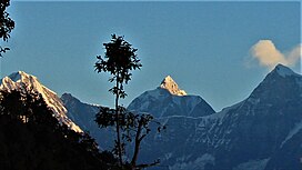
Janhukut and
Chaukhamba from Kartick Swamy from (L-R)
476:"First Ascent of Janhukot (6,805 m) in the Himalaya"
173:
168:
154:
140:
99:
60:
50:
40:
35:
18:
205:Their attempt was the highest up to that date, .
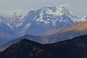
30:Mandani Janhukut and Chaukhamba IV from (L-R)
8:
15:
234:
428:
412:List of Himalayan peaks of Uttarakhand
7:
14:
257:, 7,075 m (23,212 ft),
501:Six-thousanders of the Himalayas
248:neighboring peaks of Janhukut:
118:
117:
110:
24:
371:, 6,193 m (21175 ft)
333:, 7,138 m (23419 ft)
295:, 6,721 m (22051 ft)
1:
506:Geography of Chamoli district
46:6,805 m (22,326 ft)
522:
56:797 m (2,615 ft)
104:
23:
496:Mountains of Uttarakhand
131:Location in Uttarakhand
417:Gangotri National Park
240:
219:Gangotri National Park
390:30.73361°N 79.19917°E
352:30.88194°N 79.13361°E
314:30.80944°N 79.22417°E
276:30.84500°N 79.21250°E
238:
84:30.77833°N 79.24167°E
386: /
348: /
310: /
272: /
209:Glaciers and rivers
80: /
395:30.73361; 79.19917
357:30.88194; 79.13361
319:30.80944; 79.22417
281:30.84500; 79.21250
241:
89:30.77833; 79.24167
36:Highest point
244:Neighboring peaks
183:
182:
513:
480:
479:
472:
466:
461:
455:
454:
447:
441:
440:
433:
401:
400:
398:
397:
396:
391:
387:
384:
383:
382:
379:
363:
362:
360:
359:
358:
353:
349:
346:
345:
344:
341:
325:
324:
322:
321:
320:
315:
311:
308:
307:
306:
303:
287:
286:
284:
283:
282:
277:
273:
270:
269:
268:
265:
196:Climbing history
163:Garhwal Himalaya
158:
121:
120:
114:
95:
94:
92:
91:
90:
85:
81:
78:
77:
76:
73:
28:
16:
521:
520:
516:
515:
514:
512:
511:
510:
486:
485:
484:
483:
478:. 19 June 2018.
474:
473:
469:
462:
458:
449:
448:
444:
435:
434:
430:
425:
408:
394:
392:
388:
385:
380:
377:
375:
373:
372:
356:
354:
350:
347:
342:
339:
337:
335:
334:
318:
316:
312:
309:
304:
301:
299:
297:
296:
280:
278:
274:
271:
266:
263:
261:
259:
258:
246:
211:
198:
156:
136:
135:
134:
133:
132:
129:
128:
127:
126:
122:
88:
86:
82:
79:
74:
71:
69:
67:
66:
31:
12:
11:
5:
519:
517:
509:
508:
503:
498:
488:
487:
482:
481:
467:
456:
442:
427:
426:
424:
421:
420:
419:
414:
407:
404:
403:
402:
368:Mandani Parbat
364:
326:
288:
245:
242:
210:
207:
197:
194:
181:
180:
177:
171:
170:
166:
165:
160:
152:
151:
142:
138:
137:
130:
124:
123:
116:
115:
109:
108:
107:
106:
105:
102:
101:
97:
96:
64:
58:
57:
54:
48:
47:
44:
38:
37:
33:
32:
29:
21:
20:
13:
10:
9:
6:
4:
3:
2:
518:
507:
504:
502:
499:
497:
494:
493:
491:
477:
471:
468:
465:
460:
457:
452:
446:
443:
438:
432:
429:
422:
418:
415:
413:
410:
409:
405:
399:
370:
369:
365:
361:
332:
331:
327:
323:
294:
293:
289:
285:
256:
255:
251:
250:
249:
243:
237:
233:
231:
227:
224:
220:
215:
208:
206:
202:
195:
193:
191:
187:
178:
176:
172:
167:
164:
161:
159:
153:
150:
146:
143:
139:
113:
103:
98:
93:
65:
63:
59:
55:
53:
49:
45:
43:
39:
34:
27:
22:
17:
470:
459:
445:
431:
366:
330:Chaukhamba I
328:
290:
252:
247:
216:
212:
203:
199:
185:
184:
175:First ascent
157:Parent range
393: /
355: /
317: /
279: /
145:Uttarakhand
87: /
62:Coordinates
490:Categories
451:"Janhukut"
423:References
381:79°11′57″E
378:30°44′01″N
343:79°08′01″E
340:30°52′55″N
305:79°13′27″E
302:30°48′34″N
267:79°12′45″E
264:30°50′42″N
230:Kerdarnath
190:Nanda Devi
75:79°14′30″E
72:30°46′42″N
52:Prominence
292:Swachhand
254:Satopanth
228:Tapoban,
100:Geography
42:Elevation
406:See also
223:Gangotri
186:Janhukut
169:Climbing
141:Location
125:Janhukut
19:Janhukut
437:"Error"
226:Gomukh
149:India
492::
147:,
453:.
439:.
Text is available under the Creative Commons Attribution-ShareAlike License. Additional terms may apply.