706:. A broad glacier tongue extending eastward from the Mawson Glacier into the Ross Sea. Discovered by the BrNAE (1901-04) and named for Otto Nordenskjold, Swedish geographer who led an expedition to Antarctica in 1901. This feature had become well established by the name Nordenskjold Ice Tongue prior to initiation of systematic application of common specific names to a glacier and its glacier tongue. Although this feature is a glacier tongue, the generic term ice tongue is retained in the name to reduce ambiguity.
39:
275:
267:
668:. A cape on the coast of Victoria Land 3 nautical miles (5.6 km; 3.5 mi) north of Cape Day. The cape is marked by a rock exposure and is situated at the south side of the terminus of Mawson Glacier. Mapped by USGS from surveys and U.S Navy aerial photographs, 1957-61. Named by US-ACAN for Joseph R. Cornely, USN, radioman with the wintering parties at Little America V, South Pole Station, and McMurdo Station in three years, 1958, 1961 and 1963.
630:. Cape on the coast of Victoria Land, just east of Charcot Cove and Marin Glacier. It forms the outer, north portal of the re-entrant through which Mawson Glacier flows to the Ross Sea. Mapped by USGS from ground surveys and Navy air photos. Named by US-ACAN in 1964 for Lt. John Hickey, USN, pilot with Navy Squadron VX-6, who participated in Topo North and South surveys in 1962.
397:. A moraine located 8 nautical miles (15 km; 9.2 mi) west of Reckling Peak, the latter at the head of Mawson Glacier. The site of the moraine is part of a long, narrow patch of bare ice that extends west from Reckling Peak, from which the moraine is named. The name arose following the collection of meteorites at the moraine by a USARP field party in the 1979-80 season.
46:
1032:
1354:
359:. An isolated peak, 2,010 metres (6,590 ft) high, which surmounts the central part of a ridge located at the icefalls at the head of Mawson Glacier. Mapped by USGS from ground surveys and Navy air photos. Named by US-ACAN in 1964 for Lt. Commander Darold L. Reckling, pilot with U.S. Navy Squadron VX-6, 1961.
194:
After the Last
Glacial Maximum (LGM) there was dynamic retreat of the ice sheet covering the Ross Sea in the Mawson Glacier region. The glacier thinned abruptly between 7,500 and 4,500 years ago, then thinned more gradually until recently. This thinning was very similar to what happened at the
473:. A large nunatak in the stream of the Mawson Glacier, about 5 nautical miles (9.3 km; 5.8 mi) north of the Convoy Range in Victoria Land. Mapped in 1957 by the New Zealand Northern Survey party of the CTAE (1956-58), which applied the name because of its three summits.
592:. A point situated at the south side of Charcot Cove on the coast of Victoria Land. Discovered by the BrNAE (1901-04) under Capt. Robert F. Scott, who named the feature for William S. Bruce, leader of the Scottish National Antarctic Expedition (1902-04).
435:. Nunatak lying 7 nautical miles (13 km; 8.1 mi) west-northwest of the main summit of Trinity Nunatak in the stream of the Mawson Glacier. Named by US-ACAN in 1964 for Lt. Commander Michael Jarina, pilot with U.S. Navy Squadron VX-6 in 1962.
554:. A glacier just west of Cape Hickey, flowing southeast into Charcot Cove on the coast of Victoria Land. Mapped by USGS from ground surveys and Navy air photos. Named by US-AC AN in 1964 for Bonifacio Marin, engineman at McMurdo Station, 1962.
321:. It is mostly ice free and has a number of small peaks running in a line west from the main peak. Discovered and named by the New Zealand party (1957-58) of the CTAE. The name describes the steep rock peaks of the nunatak.
1036:
516:. A re-entrant in the coast of Victoria Land between Bruce Point and Cape Hickey. Discovered by the BrNAE (1901-04) which named this feature for Dr. Jean B. Charcot, noted Arctic and Antarctic explorer.
1079:
Jones, R.S.; Whitmore, R.J.; Mackintosh, A.N.; Norton, K.P.; Eaves, S.R.; Stutz, J.; Christl, M. (2020), "Regional-scale abrupt Mid-Holocene ice sheet thinning in the western Ross Sea, Antarctica",
1230:
1280:
1200:
1195:
1121:
215:
to its south. It flows past
Charcot Cove and Bruce Point to the north and the Oates Piedmont Glacier and Cape Day to its south, to terminate in the NordenSkjold Ice Tongue.
207:
The Mawson
Glacier rises on the Antarctic Plateau. Features of the region of its head include Battlements Nunatak, Reckling Peak, Jarina Nunatak and Trinity Nunatak. The
1275:
1240:
1149:
1144:
1306:
1270:
1205:
1245:
211:
and
Chattahoochee Glacier flows into the head of the glacier. Mawson Glacier flows east past the Walker Rocks and Mount Murray to its north and the
1260:
1215:
1114:
1040:
76:
1255:
1250:
1220:
1374:
1180:
1165:
1107:
38:
1285:
1265:
1170:
1130:
798:. First charted by the BrAE (1907-09) which named this cape after Bernard C. Day, electrician and motor expert with the expedition.
1185:
199:
100 kilometres (62 mi) to the south. Probably the ice sheet retreat and glacial ice drawdown were caused by ocean warming.
1290:
1235:
1190:
1225:
1175:
134:
1321:
1316:
1210:
69:
752:
and Mawson
Glacier. Surveyed in 1957 and named by the N.Z. Northern Survey Party of the CTAE (1956-58) after Capt.
1344:
317:. A large nunatak near the head of Mawson Glacier, about 6 nautical miles (11 km; 6.9 mi) northwest of
766:
716:
678:
640:
602:
564:
526:
488:
445:
407:
369:
331:
289:
228:
1379:
255:
274:
753:
250:
756:
who, with
Captain Scott and three companions, perished on the return from the South Pole in 1912.
186:, the expedition physicist, who later led two other Antarctic expeditions, 1911–14, and 1929–31.
266:
245:
179:
167:
1358:
1326:
1088:
1063:
794:. A cape on the coast of Victoria Land 11 nautical miles (20 km; 13 mi) east of
1047:
745:
212:
196:
183:
171:
1368:
208:
163:
62:
1331:
1014:
178:, where it forms the Nordenskjöld Ice Tongue. The glacier was first mapped by the
795:
749:
318:
240:
17:
781:
768:
731:
718:
693:
680:
655:
642:
617:
604:
579:
566:
541:
528:
503:
490:
460:
447:
422:
409:
384:
371:
346:
333:
304:
291:
149:
136:
91:
78:
1099:
1311:
175:
119:
1092:
273:
265:
1103:
825:
748:, occupying the whole of the coastal platform between the
872:
870:
1342:
1022:(2 ed.), United States Board on Geographic Names
1299:
1158:
1137:
115:
107:
68:
58:
849:
1115:
837:
8:
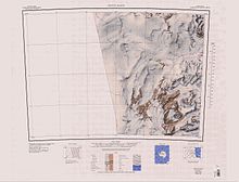
744:An extensive lowland ice sheet east of the
270:Upper section of the glacier (to the north)
166:, Antarctica, descending eastward from the
1307:List of Antarctic and subantarctic islands
1122:
1108:
1100:
162:) is a large glacier on the east coast of
111:35 nautical miles (65 km; 40 mi)
29:
170:to the north of Trinity Nunatak and the
1349:
1068:, USGS: United States Geological Survey
1052:, USGS: United States Geological Survey
1041:United States Board on Geographic Names
996:
984:
972:
960:
948:
936:
924:
912:
900:
888:
876:
861:
813:
806:
1150:List of glaciers in the Antarctic: I–Z
1145:List of glaciers in the Antarctic: A–H
45:
7:
1231:Palmer Archipelago and Graham Land
1039:from websites or documents of the
25:
1281:Trinity Peninsula and Graham Land
1201:James Ross Island and Graham Land
1196:Heard Island and McDonald Islands
1016:Geographic Names of the Antarctic
1352:
1035: This article incorporates
1030:
278:Lower section (to the northwest)
44:
37:
1013:Alberts, Fred G., ed. (1995),
1:
1332:List of subantarctic glaciers
1322:List of Antarctic ice streams
1317:List of Antarctic ice shelves
180:British Antarctic Expedition
1312:List of Antarctic ice rises
256:GPX (secondary coordinates)
1396:
1375:Glaciers of Victoria Land
1131:Glaciers in the Antarctic
251:GPX (primary coordinates)
226:Map all coordinates using
32:
234:Download coordinates as:
182:(1907–09) and named for
1241:Princess Elizabeth Land
672:Nordenskjöld Ice Tongue
1271:South Shetland Islands
1206:Kaiser Wilhelm II Land
1037:public domain material
710:Oates Piedmont Glacier
279:
271:
277:
269:
246:GPX (all coordinates)
27:Glacier in Antarctica
1276:South Orkney Islands
1246:Queen Elizabeth Land
850:Franklin Island USGS
1216:Mac. Robertson Land
778: /
754:Lawrence E.G. Oates
728: /
690: /
652: /
614: /
576: /
538: /
500: /
457: /
419: /
381: /
343: /
301: /
283:Battlements Nunatak
146: /
88: /
782:76.300°S 162.767°E
732:76.417°S 162.583°E
694:76.183°S 162.750°E
656:76.233°S 162.750°E
618:76.083°S 162.633°E
580:76.133°S 162.433°E
542:76.067°S 162.367°E
504:76.117°S 162.400°E
461:76.433°S 160.633°E
423:76.383°S 160.167°E
385:76.250°S 158.667°E
347:76.267°S 159.250°E
305:76.533°S 159.350°E
280:
272:
150:76.217°S 162.083°E
92:76.217°S 162.083°E
1340:
1339:
838:Convoy Range USGS
826:Jones et al. 2020
168:Antarctic Plateau
125:
124:
16:(Redirected from
1387:
1357:
1356:
1355:
1348:
1327:List of glaciers
1124:
1117:
1110:
1101:
1095:
1093:10.1130/G48347.1
1075:
1074:
1073:
1059:
1058:
1057:
1034:
1033:
1029:
1028:
1027:
1021:
1000:
994:
988:
982:
976:
970:
964:
958:
952:
946:
940:
934:
928:
922:
916:
910:
904:
898:
892:
886:
880:
874:
865:
859:
853:
847:
841:
835:
829:
823:
817:
811:
793:
792:
790:
789:
788:
787:-76.300; 162.767
783:
779:
776:
775:
774:
771:
743:
742:
740:
739:
738:
737:-76.417; 162.583
733:
729:
726:
725:
724:
721:
705:
704:
702:
701:
700:
699:-76.183; 162.750
695:
691:
688:
687:
686:
683:
667:
666:
664:
663:
662:
661:-76.233; 162.750
657:
653:
650:
649:
648:
645:
629:
628:
626:
625:
624:
623:-76.083; 162.633
619:
615:
612:
611:
610:
607:
591:
590:
588:
587:
586:
585:-76.133; 162.433
581:
577:
574:
573:
572:
569:
553:
552:
550:
549:
548:
547:-76.067; 162.367
543:
539:
536:
535:
534:
531:
515:
514:
512:
511:
510:
509:-76.117; 162.400
505:
501:
498:
497:
496:
493:
472:
471:
469:
468:
467:
466:-76.433; 160.633
462:
458:
455:
454:
453:
450:
434:
433:
431:
430:
429:
428:-76.383; 160.167
424:
420:
417:
416:
415:
412:
396:
395:
393:
392:
391:
390:-76.250; 158.667
386:
382:
379:
378:
377:
374:
363:Reckling Moraine
358:
357:
355:
354:
353:
352:-76.267; 159.250
348:
344:
341:
340:
339:
336:
316:
315:
313:
312:
311:
310:-76.533; 159.350
306:
302:
299:
298:
297:
294:
161:
160:
158:
157:
156:
155:-76.217; 162.083
151:
147:
144:
143:
142:
139:
103:
102:
100:
99:
98:
97:-76.217; 162.083
93:
89:
86:
85:
84:
81:
48:
47:
41:
30:
21:
1395:
1394:
1390:
1389:
1388:
1386:
1385:
1384:
1365:
1364:
1363:
1353:
1351:
1343:
1341:
1336:
1295:
1261:Ross Dependency
1256:Queen Maud Land
1251:Queen Mary Land
1221:Marie Byrd Land
1154:
1133:
1128:
1098:
1078:
1071:
1069:
1065:Franklin Island
1062:
1055:
1053:
1046:
1031:
1025:
1023:
1019:
1012:
1008:
1003:
995:
991:
983:
979:
971:
967:
959:
955:
947:
943:
935:
931:
923:
919:
911:
907:
899:
895:
887:
883:
875:
868:
860:
856:
848:
844:
836:
832:
824:
820:
812:
808:
804:
786:
784:
780:
777:
772:
769:
767:
765:
764:
762:
736:
734:
730:
727:
722:
719:
717:
715:
714:
712:
698:
696:
692:
689:
684:
681:
679:
677:
676:
674:
660:
658:
654:
651:
646:
643:
641:
639:
638:
636:
622:
620:
616:
613:
608:
605:
603:
601:
600:
598:
584:
582:
578:
575:
570:
567:
565:
563:
562:
560:
546:
544:
540:
537:
532:
529:
527:
525:
524:
522:
508:
506:
502:
499:
494:
491:
489:
487:
486:
484:
479:
465:
463:
459:
456:
451:
448:
446:
444:
443:
441:
439:Trinity Nunatak
427:
425:
421:
418:
413:
410:
408:
406:
405:
403:
389:
387:
383:
380:
375:
372:
370:
368:
367:
365:
351:
349:
345:
342:
337:
334:
332:
330:
329:
327:
309:
307:
303:
300:
295:
292:
290:
288:
287:
285:
264:
263:
262:
261:
260:
221:
205:
192:
174:, to enter the
154:
152:
148:
145:
140:
137:
135:
133:
132:
96:
94:
90:
87:
82:
79:
77:
75:
74:
54:
53:
52:
51:
50:
49:
28:
23:
22:
15:
12:
11:
5:
1393:
1391:
1383:
1382:
1377:
1367:
1366:
1362:
1361:
1338:
1337:
1335:
1334:
1329:
1324:
1319:
1314:
1309:
1303:
1301:
1297:
1296:
1294:
1293:
1288:
1283:
1278:
1273:
1268:
1263:
1258:
1253:
1248:
1243:
1238:
1233:
1228:
1223:
1218:
1213:
1208:
1203:
1198:
1193:
1188:
1183:
1181:Ellsworth Land
1178:
1173:
1168:
1162:
1160:
1156:
1155:
1153:
1152:
1147:
1141:
1139:
1135:
1134:
1129:
1127:
1126:
1119:
1112:
1104:
1097:
1096:
1087:(3): 278–282,
1076:
1060:
1044:
1009:
1007:
1004:
1002:
1001:
999:, p. 177.
989:
987:, p. 537.
977:
975:, p. 530.
965:
963:, p. 153.
953:
951:, p. 333.
941:
929:
927:, p. 462.
917:
915:, p. 129.
905:
903:, p. 759.
893:
891:, p. 369.
881:
879:, p. 607.
866:
854:
842:
830:
828:, p. 278.
818:
816:, p. 471.
805:
803:
800:
761:
758:
746:Kirkwood Range
711:
708:
673:
670:
635:
632:
597:
594:
559:
556:
521:
518:
483:
480:
478:
475:
440:
437:
402:
401:Jarina Nunatak
399:
364:
361:
326:
323:
284:
281:
259:
258:
253:
248:
243:
237:
231:
224:
223:
222:
220:
217:
213:Kirkwood Range
204:
201:
197:Mackay Glacier
191:
188:
184:Douglas Mawson
172:Kirkwood Range
129:Mawson Glacier
123:
122:
117:
113:
112:
109:
105:
104:
72:
66:
65:
60:
56:
55:
43:
42:
36:
35:
34:
33:
26:
24:
18:Jarina Nunatak
14:
13:
10:
9:
6:
4:
3:
2:
1392:
1381:
1378:
1376:
1373:
1372:
1370:
1360:
1350:
1346:
1333:
1330:
1328:
1325:
1323:
1320:
1318:
1315:
1313:
1310:
1308:
1305:
1304:
1302:
1300:Miscellaneous
1298:
1292:
1289:
1287:
1286:Victoria Land
1284:
1282:
1279:
1277:
1274:
1272:
1269:
1267:
1266:South Georgia
1264:
1262:
1259:
1257:
1254:
1252:
1249:
1247:
1244:
1242:
1239:
1237:
1234:
1232:
1229:
1227:
1224:
1222:
1219:
1217:
1214:
1212:
1209:
1207:
1204:
1202:
1199:
1197:
1194:
1192:
1189:
1187:
1184:
1182:
1179:
1177:
1174:
1172:
1171:Bouvet Island
1169:
1167:
1164:
1163:
1161:
1157:
1151:
1148:
1146:
1143:
1142:
1140:
1136:
1132:
1125:
1120:
1118:
1113:
1111:
1106:
1105:
1102:
1094:
1090:
1086:
1082:
1077:
1067:
1066:
1061:
1051:
1050:
1045:
1042:
1038:
1018:
1017:
1011:
1010:
1005:
998:
993:
990:
986:
981:
978:
974:
969:
966:
962:
957:
954:
950:
945:
942:
939:, p. 99.
938:
933:
930:
926:
921:
918:
914:
909:
906:
902:
897:
894:
890:
885:
882:
878:
873:
871:
867:
864:, p. 50.
863:
858:
855:
851:
846:
843:
839:
834:
831:
827:
822:
819:
815:
810:
807:
801:
799:
797:
791:
759:
757:
755:
751:
747:
741:
709:
707:
703:
671:
669:
665:
633:
631:
627:
595:
593:
589:
557:
555:
551:
520:Marin Glacier
519:
517:
513:
481:
476:
474:
470:
438:
436:
432:
400:
398:
394:
362:
360:
356:
325:Reckling Peak
324:
322:
320:
314:
282:
276:
268:
257:
254:
252:
249:
247:
244:
242:
239:
238:
236:
235:
230:
229:OpenStreetMap
227:
218:
216:
214:
210:
209:Odell Glacier
202:
200:
198:
189:
187:
185:
181:
177:
173:
169:
165:
164:Victoria Land
159:
130:
121:
118:
114:
110:
106:
101:
73:
71:
67:
64:
63:Victoria Land
61:
57:
40:
31:
19:
1186:Enderby Land
1159:By territory
1084:
1080:
1070:, retrieved
1064:
1054:, retrieved
1049:Convoy Range
1048:
1024:, retrieved
1015:
997:Alberts 1995
992:
985:Alberts 1995
980:
973:Alberts 1995
968:
961:Alberts 1995
956:
949:Alberts 1995
944:
937:Alberts 1995
932:
925:Alberts 1995
920:
913:Alberts 1995
908:
901:Alberts 1995
896:
889:Alberts 1995
884:
877:Alberts 1995
862:Alberts 1995
857:
845:
833:
821:
814:Alberts 1995
809:
763:
713:
675:
637:
634:Cape Cornely
599:
561:
523:
485:
482:Charcot Cove
442:
404:
366:
328:
286:
233:
232:
225:
206:
193:
128:
126:
1380:Scott Coast
1291:Wilkes Land
1236:Palmer Land
1191:Graham Land
1166:Adélie Land
796:Mount Gauss
785: /
750:Fry Glacier
735: /
697: /
659: /
621: /
596:Cape Hickey
583: /
558:Bruce Point
545: /
507: /
464: /
426: /
388: /
350: /
319:Allan Hills
308: /
153: /
95: /
70:Coordinates
1369:Categories
1226:Oates Land
1176:Coats Land
1138:Alphabetic
1072:2024-01-02
1056:2024-01-02
1026:2023-12-03
802:References
190:Glaciology
1359:Geography
1211:Kemp Land
773:162°46′E
760:Cape Day
723:162°35′E
685:162°45′E
647:162°45′E
609:162°38′E
571:162°26′E
533:162°22′E
495:162°24′E
452:160°38′E
414:160°10′E
376:158°40′E
338:159°15′E
296:159°21′E
219:Features
176:Ross Sea
120:Ross Sea
116:Terminus
59:Location
1081:Geology
1006:Sources
770:76°18′S
720:76°25′S
682:76°11′S
644:76°14′S
606:76°05′S
568:76°08′S
530:76°04′S
492:76°07′S
449:76°26′S
411:76°23′S
373:76°15′S
335:76°16′S
293:76°32′S
141:162°5′E
138:76°13′S
83:162°5′E
80:76°13′S
1345:Portal
203:Course
108:Length
1020:(PDF)
477:Mouth
127:The
1089:doi
241:KML
1371::
1085:49
1083:,
869:^
1347::
1123:e
1116:t
1109:v
1091::
1043:.
852:.
840:.
131:(
20:)
Text is available under the Creative Commons Attribution-ShareAlike License. Additional terms may apply.