835:
371:
567:
158:
142:
24:
165:
399:
diverts water from the main stream closer to
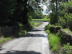
Johnville House before reconnecting with the Powerstown River. So the bridge is actually a set of two; one double arched bridge over the Powerstown River, and a single arched bridge over the tributary stream with the roadway being raised above the ground
378:
The name
Jeanville comes from Johnville House built in the 18th century. Later it was used as the name of the bridge next to it, then also used to describe the immediate area around the house which gradually changed because of a concentration of
400:
but still walled in on both sides. On the up-river side of the tributary there is a water filled depression known as the "watering hole" where a seasonal river joins onto the divert before flowing under the single arch section.
498:
804:
880:
465:
189:
899:
814:
799:
409:
322:
141:
809:
107:
157:
904:
873:
45:
458:
308:
88:
551:
546:
316:
60:
866:
761:
643:
618:
41:
370:
34:
693:
67:
728:
451:
834:
566:
374:
An 1842 OSI map of
Kilkenny (sheet 29) showing "Johnville Bridge" and "Power" with Johnville House centre left
623:
511:
392:
74:
756:
653:
608:
395:
maps but is also unusual in design. This is because in close proximity to the
Powerstown River, a branch
56:
293:
229:
304:
241:
283:
339:
850:
343:
842:
526:
475:
351:
347:
246:
786:
593:
81:
893:
698:
663:
603:
383:
in the area. Johnville House still exists today but does not use the earlier name.
359:
781:
751:
718:
678:
633:
628:
516:
506:
484:
429:
355:
23:
766:
673:
583:
556:
541:
204:
191:
776:
723:
713:
708:
703:
683:
658:
648:
638:
598:
588:
443:
396:
274:
738:
668:
536:
531:
489:
380:
335:
234:
846:
746:
688:
613:
391:
The bridge still retains the original name of
Johnville Bridge on all
521:
279:
369:
300:
447:
17:
565:
854:
737:
576:
497:
315:
290:
273:
265:
257:
252:
240:
228:
220:
125:
48:. Unsourced material may be challenged and removed.
146:View of Johnville Bridge on the Powerstown River
805:Category:Mountains and hills of County Kilkenny
874:
459:
8:
881:
867:
466:
452:
444:
122:
841:This article related to the geography of
108:Learn how and when to remove this message
421:
314:
272:
264:
251:
219:
184:
150:
138:
815:Category:Geography of County Kilkenny
289:
256:
239:
227:
7:
831:
829:
800:List of townlands of County Kilkenny
410:List of townlands in County Kilkenny
354:, Ireland. Nearby is the village of
46:adding citations to reliable sources
261:0.25 km (0.10 sq mi)
853:. You can help Knowledge (XXG) by
810:Category:Rivers of County Kilkenny
14:
164:
833:
163:
156:
140:
22:
33:needs additional citations for
1:
120:Townland in Leinster, Ireland
900:Townlands of County Kilkenny
921:
828:
795:
563:
482:
185:
151:
139:
132:
905:Ireland geography stubs
393:Ordnance Survey Ireland
269:50 m (160 ft)
570:
375:
358:and country estate of
205:52.616696°N 7.012228°W
569:
373:
292: • Summer (
317:Irish grid reference
210:52.616696; -7.012228
42:improve this article
434:homepage.eircom.net
201: /
177:Location in Ireland
571:
376:
334:is an area in the
258: • Total
862:
861:
823:
822:
329:
328:
118:
117:
110:
92:
912:
883:
876:
869:
837:
830:
468:
461:
454:
445:
438:
437:
426:
387:Johnville Bridge
325:
297:
216:
215:
213:
212:
211:
206:
202:
199:
198:
197:
194:
167:
166:
160:
144:
123:
113:
106:
102:
99:
93:
91:
50:
26:
18:
920:
919:
915:
914:
913:
911:
910:
909:
890:
889:
888:
887:
843:County Kilkenny
826:
824:
819:
791:
733:
572:
561:
493:
478:
476:County Kilkenny
472:
442:
441:
428:
427:
423:
418:
406:
389:
368:
352:County Kilkenny
321:
291:
247:County Kilkenny
209:
207:
203:
200:
195:
192:
190:
188:
187:
181:
180:
179:
178:
175:
174:
173:
172:
168:
147:
135:
128:
121:
114:
103:
97:
94:
51:
49:
39:
27:
12:
11:
5:
918:
916:
908:
907:
902:
892:
891:
886:
885:
878:
871:
863:
860:
859:
838:
821:
820:
818:
817:
812:
807:
802:
796:
793:
792:
790:
789:
787:Sandfordscourt
784:
779:
774:
769:
764:
759:
754:
749:
743:
741:
735:
734:
732:
731:
726:
721:
716:
711:
706:
701:
696:
691:
686:
681:
676:
671:
666:
661:
656:
651:
646:
641:
636:
631:
626:
621:
616:
611:
606:
601:
596:
594:Bennettsbridge
591:
586:
580:
578:
574:
573:
564:
562:
560:
559:
554:
549:
544:
539:
534:
529:
524:
519:
514:
509:
503:
501:
495:
494:
483:
480:
479:
473:
471:
470:
463:
456:
448:
440:
439:
420:
419:
417:
414:
413:
412:
405:
402:
388:
385:
367:
364:
327:
326:
319:
313:
312:
298:
288:
287:
277:
271:
270:
267:
263:
262:
259:
255:
254:
250:
249:
244:
238:
237:
232:
226:
225:
222:
218:
217:
183:
182:
176:
170:
169:
162:
161:
155:
154:
153:
152:
149:
148:
145:
137:
136:
133:
130:
129:
126:
119:
116:
115:
30:
28:
21:
13:
10:
9:
6:
4:
3:
2:
917:
906:
903:
901:
898:
897:
895:
884:
879:
877:
872:
870:
865:
864:
858:
856:
852:
848:
844:
839:
836:
832:
827:
816:
813:
811:
808:
806:
803:
801:
798:
797:
794:
788:
785:
783:
780:
778:
775:
773:
770:
768:
765:
763:
760:
758:
755:
753:
750:
748:
745:
744:
742:
740:
736:
730:
727:
725:
722:
720:
717:
715:
712:
710:
707:
705:
702:
700:
697:
695:
692:
690:
687:
685:
682:
680:
677:
675:
672:
670:
667:
665:
662:
660:
657:
655:
652:
650:
647:
645:
642:
640:
637:
635:
632:
630:
627:
625:
622:
620:
617:
615:
612:
610:
607:
605:
602:
600:
597:
595:
592:
590:
587:
585:
582:
581:
579:
575:
568:
558:
555:
553:
550:
548:
545:
543:
540:
538:
535:
533:
530:
528:
527:Graignamanagh
525:
523:
520:
518:
515:
513:
510:
508:
505:
504:
502:
500:
496:
492:
491:
486:
481:
477:
469:
464:
462:
457:
455:
450:
449:
446:
435:
431:
425:
422:
415:
411:
408:
407:
403:
401:
398:
394:
386:
384:
382:
372:
365:
363:
361:
357:
353:
349:
345:
341:
337:
333:
324:
320:
318:
310:
306:
302:
299:
295:
285:
281:
278:
276:
268:
260:
248:
245:
243:
236:
233:
231:
223:
214:
186:Coordinates:
159:
143:
131:
124:
112:
109:
101:
90:
87:
83:
80:
76:
73:
69:
66:
62:
59: –
58:
54:
53:Find sources:
47:
43:
37:
36:
31:This article
29:
25:
20:
19:
16:
855:expanding it
840:
825:
771:
699:Riverquarter
664:Killinaspick
604:Castlewarren
488:
433:
424:
390:
377:
360:Mount Loftus
331:
330:
104:
98:January 2023
95:
85:
78:
71:
64:
52:
40:Please help
35:verification
32:
15:
782:Loughcullen
752:Ballyragget
719:Tullahought
679:Knocktopher
634:Hugginstown
629:Goresbridge
517:Castlecomer
507:Ballyragget
485:County town
356:Goresbridge
208: /
57:"Jeanville"
894:Categories
767:Hoodsgrove
674:Kilmoganny
584:Aughamucky
557:Urlingford
552:Thomastown
547:Stoneyford
542:Mullinavat
474:Places in
416:References
340:Powerstown
193:52°37′00″N
68:newspapers
777:Lisdowney
772:Jeanville
762:Flagmount
739:Townlands
724:Tullaroan
714:Slieverue
709:The Rower
704:Rosbercon
684:Paulstown
659:Killamery
649:Johnswell
644:Johnstown
639:Inistioge
619:Freshford
599:Carrigeen
589:Ballyhale
397:tributary
381:Huguenots
332:Jeanville
275:Time zone
266:Elevation
196:7°00′44″W
171:Jeanville
127:Jeanville
694:Redhouse
669:Kilmacow
577:Villages
537:Mooncoin
532:Kilkenny
490:Kilkenny
430:"HSESIJ"
404:See also
336:townland
235:Leinster
230:Province
134:Townland
847:Ireland
747:Ballyda
729:Windgap
689:Piltown
614:Fiddown
366:History
342:in the
323:S679519
224:Ireland
221:Country
82:scholar
624:Galmoy
522:Gowran
512:Callan
348:Gowran
344:barony
242:County
84:
77:
70:
63:
55:
849:is a
757:Clogh
654:Kells
609:Clogh
499:Towns
301:UTC-1
280:UTC+0
89:JSTOR
75:books
851:stub
309:WEST
253:Area
61:news
350:in
346:of
338:of
305:IST
294:DST
284:WET
44:by
896::
845:,
487::
432:.
362:.
311:))
882:e
875:t
868:v
857:.
467:e
460:t
453:v
436:.
307:(
303:(
296:)
286:)
282:(
111:)
105:(
100:)
96:(
86:·
79:·
72:·
65:·
38:.
Text is available under the Creative Commons Attribution-ShareAlike License. Additional terms may apply.