17:
116:
132:
51:
which leaves out small plateaus or ridges in between. When the block summits in joint valley landscape are of different height it may indicate the past movement of a vertical
115:
131:
101:(lit. square plateau land). Joint valley landscapes are among the few places in southern Sweden where there are steep slopes in excess of 25°.
16:
184:
58:
238:. Statens offentliga utreningar (in Swedish). Vol. 39. Stockholm: Jordbruksdepartamentet. 1943. p. 21.
233:
235:
Utredning angående
Norrlands näringsliv. Förberendade undersökning verkställd av 1940 års norrlandsutredning
189:
86:
21:
281:
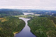
213:
261:
286:
253:
32:
89:. In addition to this there is a large-scale joint valley landscape that extends from the
52:
44:
142:
122:
275:
254:
249:
208:
94:
40:
74:
70:
66:
90:
85:. In the last three areas the flat summits of the landscapes are parts of the
82:
78:
62:
48:
138:
187:(1995). "Relief and saprolites through time on the Baltic Shield".
252:(1997). "Sweden". In Embleton, C.; Embleton-Hamann, C. (eds.).
221:. Swedish Society for Anthropology and Geography: 125–136.
173:(in Swedish). Nordiska ministerrådet. 1984. p. 9.
61:
identified joint valley landscape areas centered on
93:inland. The landscape type was first identified by
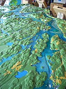
137:Model of the joint valley landscape around lake
43:. The landscape originates from the erosion of
211:(1926). "Norra Sveriges landforms-regioner".
8:
165:
163:
20:Joint valley terrain seen in wintertime
15:
159:
111:
121:Large scale joint valley landscape at
37:sprickdalslandskap, sprickdalsterräng
7:
256:Geomorphological Hazards of Europe
14:
130:
114:
39:) is a type of relief common in
1:
31:or fissure valley terrain (
303:
185:Lidmar-Bergströrm, Karna
171:Terrängformer i Norden
97:who in 1926 called it
87:Sub-Cambrian peneplain
59:Karna Lidmar-Bergström
36:
29:Joint valley landscape
25:
22:Stockholm archipelago
19:
260:. Elsevier. p.
232:"Regionindelning".
214:Geografiska Annaler
197:. Elsevier: 45–61.
26:
294:
266:
265:
259:
246:
240:
239:
229:
223:
222:
205:
199:
198:
181:
175:
174:
167:
134:
118:
53:geological fault
302:
301:
297:
296:
295:
293:
292:
291:
272:
271:
270:
269:
248:
247:
243:
231:
230:
226:
207:
206:
202:
183:
182:
178:
169:
168:
161:
156:
151:
150:
149:
146:
135:
126:
125:, Ångermanland.
119:
107:
12:
11:
5:
300:
298:
290:
289:
284:
274:
273:
268:
267:
241:
224:
217:(in Swedish).
200:
176:
158:
157:
155:
152:
148:
147:
143:naturum Sommen
136:
129:
127:
123:The High Coast
120:
113:
110:
109:
108:
106:
103:
13:
10:
9:
6:
4:
3:
2:
299:
288:
285:
283:
280:
279:
277:
263:
258:
257:
251:
250:Rudberg, Sten
245:
242:
237:
236:
228:
225:
220:
216:
215:
210:
209:De Geer, Sten
204:
201:
196:
192:
191:
190:Geomorphology
186:
180:
177:
172:
166:
164:
160:
153:
144:
140:
133:
128:
124:
117:
112:
104:
102:
100:
96:
92:
88:
84:
80:
76:
72:
68:
64:
60:
56:
54:
50:
46:
42:
38:
34:
30:
23:
18:
255:
244:
234:
227:
218:
212:
203:
194:
188:
179:
170:
99:rutplatåland
98:
95:Sten De Geer
57:
41:Fennoscandia
28:
27:
282:Scandinavia
276:Categories
154:References
91:High Coast
83:Hudiksvall
79:Stockholm
75:Västervik
71:Linköping
67:Bohuslän
63:Blekinge
287:Geology
105:Gallery
49:bedrock
47:in the
33:Swedish
139:Sommen
45:joints
81:and
262:457
141:in
55:.
278::
195:12
193:.
162:^
77:,
69:,
65:,
35::
264:.
219:8
145:.
73:/
24:.
Text is available under the Creative Commons Attribution-ShareAlike License. Additional terms may apply.