219:
54:
26:
404:
Abu-Sharar T. (2006) THE CHALLENGES OF LAND AND WATER RESOURCES DEGRADATION IN JORDAN: DIAGNOSIS AND SOLUTIONS. In: Kepner W.G., Rubio J.L., Mouat D.A., Pedrazzini F. (eds) Desertification in the
Mediterranean Region. A Security Issue. NATO Security Through Science Series, vol 3. Springer, Dordrecht.
209:
prevails, with mild rainy winters and hot, dry summers. A desert climate prevails towards the east and south and at lower elevations. The rainy season extends from
October to May, with the heaviest rainfall between November and March. Rainfall ranges from 600 mm annually in the northern mountains to
310:
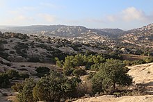
A semi-arid steppe zone lies between 600 and 800 meters elevation on the eastern slope of the mountains, where rainfall is between 200 and 350 mm annually. In the drier southern mountains the eastern steppe zone extends up to 1100 or 1200 meters elevation. There is a narrower steppe zone on the
229:
The western slopes and highest elevations are semi-arid to semi-humid, with average annual rainfall of 350 mm or more. The natural vegetation was
Mediterranean forest, woodland, and scrub, occurring above 700 meters elevation in the northwest, and between 900 and 1700 meters elevation in the
449:
306:
in the transition zone between the forests and woodlands and the lower-elevation steppe. The forests and woodlands have been reduced in area and degraded by centuries of deforestation and over-grazing by livestock.
282:). In the southern forests and woodlands oaks are found on limestone-derived soils, with open woodlands of juniper growing over sandstone. In the southern highlands there are shrublands of wild hawthorn (
311:
western slopes between the upper-elevation
Mediterranean forests and the lower-elevation deserts of the Jordan Rift Valley. Predominant steppe plants are low shrubs, particularly
116:
in the south. The highlands are crossed by several east–west wadis, or canyons, carved by permanent or intermittent streams. The northern wadis empty into the
355:
Wagner W. (2011) Northwestern
Mountain and Rift Zone of the Northern Arabian Platform. In: Groundwater in the Arab Middle East. Springer, Berlin, Heidelberg.
320:
Desert vegetation is found in the Jordan Rift Valley, the southern highlands, and the eastern plateau where average annual rainfall is 200 mm or less.
101:. From the plateau to the east the highlands appear as a series of hills. To the west the highlands drop steeply 1,000 meters or more to the
426:
Willimott, S.G., Birch, B.P., McKee, R.F., Atkinson, K., and Nimry, B.S. (1964). "Conservation Survey of the
Southern Highlands of Jordan".
230:
southwest. Forests and open woodlands are found in the northern and southern parts of the highlands. Trees in the northern forests include
385:
205:
The climate of the
Highlands ranges from north to south and with elevation. Towards the north and west and at higher elevations a
81:
depression to the west and a plateau to the east. The highlands are home to most of Jordan's population and large cities.
89:
The
Jordanian Highlands extend about 300 km north to south. The highlands are bounded on the north by the deeply-incised
444:
454:
154:, Jordan's capital and largest city and the largest city in the highlands, is in this portion, as are the towns of
266:
206:
329:
313:
250:
150:, which extend from the Zarqa River south to Wadi al-Mujib. Wadi-al-Mujib empties into the Dead Sea.
272:
240:
223:
113:
177:
is also in this portion of the highlands, on the western side of the highlands facing Wadi Araba.
290:
284:
278:
244:
102:
173:
is the largest city in this portion, near the southern end of the Dead Sea. The ancient city of
381:
296:
256:
218:
406:
356:
131:, ‘the arable land of the Jordan’, and lies between the Yarmouk River on the north and the
112:
Elevation of the higher peaks ranges from over 1,200 meters in the north to 1,700 meters at
302:
147:
127:
The highlands are divided into three main portions. The northern portion is called the
438:
194:
90:
73:. It extends north and south through the western portion of the country, between the
117:
98:
360:
231:
132:
53:
190:
121:
30:
25:
410:
120:, which flows southward into the Dead Sea. The southern wadis empty into the
166:
170:
106:
78:
186:
155:
74:
159:
140:
70:
58:
210:
50 mm in the southernmost highlands and the eastern desert plateau.
217:
174:
151:
136:
94:
135:
on the south. Both rivers are tributaries of the Jordan River.
450:
260:. Forests and woodlands in the southern highlands include
93:
valley, which forms part of the border between Jordan and
43:
38:
18:
197:was uplifted as it moves northward and clockwise.
193:) tectonic events, as the northwestern rim of the
185:The highlands were formed by relatively recent (
109:, a saline lake with a surface below sea level.
97:. They extend to south to Jordan's border with
8:
400:
398:
396:
394:
294:), and pistachio, and acacia woodlands with
422:
420:
418:
124:, which flows northward into the Dead Sea.
105:, which contains the Jordan River and the
15:
47:300 km (190 mi) north–south
351:
349:
347:
345:
143:are the largest cities in this portion.
52:
372:
370:
368:
341:
7:
139:, Jordan's second largest city, and
165:The southern portion is called the
14:
24:
1:
378:Culture and Customs of Jordan
361:10.1007/978-3-642-19351-4_2
146:The central portion is the
471:
33:in the Jordanian Highlands
380:. Greenwood Press, 2007.
23:
411:10.1007/1-4020-3760-0_08
376:Shoup, John A. (2007).
69:is a mountain range in
267:Cupressus sempervirens
226:
62:
221:
207:Mediterranean climate
56:
330:Transjordan (region)
314:Artemisia herba-alba
251:Quercus ithaburensis
169:or Jabal al-Sharat.
445:Mountains of Jordan
273:Juniperus phoenicea
262:Quercus calliprinos
241:Quercus calliprinos
238:), evergreen oaks (
224:Dana Nature Reserve
67:Jordanian Highlands
19:Jordanian Highlands
291:Amygdalus communis
285:Crataegus azarolus
279:Pistacia atlantica
276:), and pistachio (
245:Quercus infectoria
227:
103:Jordan Rift Valley
63:
455:Great Rift Valley
297:Acacia spirocarpa
257:Arbutus andrachne
51:
50:
462:
427:
424:
413:
402:
389:
374:
363:
353:
236:Pinus halepensis
28:
16:
470:
469:
465:
464:
463:
461:
460:
459:
435:
434:
431:
430:
425:
416:
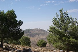
403:
392:
375:
366:
354:
343:
338:
326:
317:, and grasses.
303:Acacia raddiana
216:
203:
183:
167:Bilad al-Sharat
129:Sawad al-Urdunn
87:
61:Topographic map
34:
12:
11:
5:
468:
466:
458:
457:
452:
447:
437:
436:
429:
428:
414:
390:
364:
340:
339:
337:
334:
333:
332:
325:
322:
215:
212:
202:
199:
182:
179:
86:
83:
49:
48:
45:
41:
40:
36:
35:
29:
21:
20:
13:
10:
9:
6:
4:
3:
2:
467:
456:
453:
451:
448:
446:
443:
442:
440:
433:
423:
421:
419:
415:
412:
408:
401:
399:
397:
395:
391:
387:
386:9780313336713
383:
379:
373:
371:
369:
365:
362:
358:
352:
350:
348:
346:
342:
335:
331:
328:
327:
323:
321:
318:
316:
315:
308:
305:
304:
299:
298:
293:
292:
287:
286:
281:
280:
275:
274:
269:
268:
263:
259:
258:
253:
252:
247:
246:
242:
237:
233:
225:
220:
213:
211:
208:
200:
198:
196:
195:Arabian Plate
192:
188:
180:
178:
176:
172:
168:
163:
161:
157:
153:
149:
148:Balqa Heights
144:
142:
138:
134:
130:
125:
123:
119:
115:
114:Jebel Mubarak
110:
108:
104:
100:
96:
92:
91:Yarmouk River
84:
82:
80:
76:
72:
68:
60:
55:
46:
42:
37:
32:
27:
22:
17:
432:
388:, 0313336717
377:
319:
312:
309:
301:
295:
289:
283:
277:
271:
270:), juniper (
265:
261:
255:
249:
239:
235:
228:
222:Woodland in
204:
184:
164:
145:
128:
126:
118:Jordan River
111:
99:Saudi Arabia
88:
66:
64:
288:), almond (
264:, cypress (
232:Aleppo pine
133:Zarqa River
57:Jordan and
439:Categories
336:References
191:Quaternary
122:Wadi Araba
39:Dimensions
31:Mount Nebo
85:Geography
324:See also
171:Al-Karak
107:Dead Sea
79:Dead Sea
254:), and
214:Ecology
201:Climate
187:Neogene
181:Geology
156:Al-Salt
75:Red Sea
384:
248:, and
160:Madaba
141:Ajloun
71:Jordan
59:Israel
44:Length
175:Petra
152:Amman
137:Irbid
95:Syria
382:ISBN
300:and
158:and
65:The
407:doi
357:doi
441::
417:^
393:^
367:^
344:^
243:,
162:.
409::
359::
234:(
189:–
77:-
Text is available under the Creative Commons Attribution-ShareAlike License. Additional terms may apply.