22:
344:
151:
359:
135:
126:
220:
158:
394:
is a
Protestant stone church which seats about 90 persons. It was inaugurated on 5 March 1929 after the old church of Kópasker had been torn down. The church remained undamaged by the earthquake of 1976. The cross at the top of the tower was added in 1979 on the occasion of the 50th jubilee of the
517:
378:, providing services to local agriculture and fisheries. Meat-processing is the biggest industry in Kópasker, represented by the slaughterhouse and lamb-processing factory,
374:
The first residential house in Kópasker, Bakki, was built in 1912 by Árni
Ingimundarson. Bakki burned down in 1988. Kópasker grew around the operation of the
51:
487:
386:
by Kópasker. In the village there is also an exhibition at the Kópasker
Earthquake Center describing the big earthquake of 1976 that measured 6.3 on the
477:
433:
492:
343:
182:
398:
In Kópasker there is a shop, garage, health care centre, school, bank, campsite and guesthouses. North of Kópasker is the peninsula
91:
150:
134:
67:
249:
256:
232:
482:
358:
43:
387:
47:
237:
441:
399:
330:
410:
383:
290:
32:
317:
244:
36:
379:
56:
71:
462:
403:
60:
326:
261:
511:
402:, with its abundant birdlife, and also the northernmost point of mainland Iceland,
483:
Visit North-East
Iceland (official travel guide): Öxarfjörður and Melrakkasletta
375:
125:
197:
184:
281:
334:
322:
225:
286:
390:
and destroyed several houses and other structures in the area.
15:
497:
463:
http://kirkjukort.net/kirkjur/snartarstadakirkja_0384.html
325:
with approximately 120 inhabitants in the municipality of
54:
and tools are available to assist in formatting, such as
413:, located approximately a kilometre north of the town.
428:
426:
382:. The District Museum is located at the church site
297:
280:
272:
267:
255:
243:
231:
213:
109:
518:Populated places in Northeastern Region (Iceland)
488:North Iceland (official travel guide): Kópasker
8:
35:, which are uninformative and vulnerable to
50:and maintains a consistent citation style.
139:Location of the Municipality of Norðurþing
106:
104:Village in Northeast Constituency, Iceland
92:Learn how and when to remove this message
478:Norðurþing (official website): Kópasker
422:
339:
296:
279:
266:
212:
177:
143:
131:
122:
316:
271:
254:
242:
230:
7:
329:, situated on the eastern shore of
42:Please consider converting them to
14:
409:The village has its own airport,
357:
342:
218:
157:
156:
149:
133:
124:
20:
46:to ensure the article remains
1:
534:
318:[ˈkʰouːpaˌscɛːr̥]
178:
144:
132:
123:
116:
314:Icelandic pronunciation:
238:Northeast Constituency
349:Church of Kópasker:
493:Travelnet: Kópasker
392:Snartarstaðarkirkja
351:Snartarstaðarkirkja
250:Northeastern Region
194: /
170:Location in Iceland
273: • Total
307:
306:
198:66.300°N 16.450°W
102:
101:
94:
52:Several templates
525:
465:
460:
454:
453:
451:
449:
440:. Archived from
430:
411:Kópasker Airport
404:Hraunhafnartangi
361:
346:
320:
315:
224:
222:
221:
209:
208:
206:
205:
204:
199:
195:
192:
191:
190:
187:
160:
159:
153:
137:
128:
107:
97:
90:
86:
83:
77:
75:
64:
24:
23:
16:
533:
532:
528:
527:
526:
524:
523:
522:
508:
507:
506:
474:
469:
468:
461:
457:
447:
445:
432:
431:
424:
419:
372:
365:
362:
353:
347:
313:
303:
219:
217:
203:66.300; -16.450
202:
200:
196:
193:
188:
185:
183:
181:
180:
174:
173:
172:
171:
168:
167:
166:
165:
161:
140:
119:
112:
105:
98:
87:
81:
78:
66:
55:
41:
25:
21:
12:
11:
5:
531:
529:
521:
520:
510:
509:
505:
504:External links
502:
501:
500:
495:
490:
485:
480:
473:
472:External links
470:
467:
466:
455:
444:on 3 July 2011
438:nordurthing.is
421:
420:
418:
415:
400:Melrakkaslétta
395:inauguration.
371:
368:
367:
366:
363:
356:
354:
348:
341:
305:
304:
301:
299:
295:
294:
284:
278:
277:
274:
270:
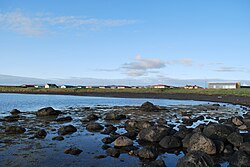
269:
265:
264:
259:
253:
252:
247:
241:
240:
235:
229:
228:
215:
211:
210:
176:
175:
169:
163:
162:
155:
154:
148:
147:
146:
145:
142:
141:
138:
130:
129:
121:
120:
117:
114:
113:
110:
103:
100:
99:
82:September 2022
44:full citations
28:
26:
19:
13:
10:
9:
6:
4:
3:
2:
530:
519:
516:
515:
513:
503:
499:
496:
494:
491:
489:
486:
484:
481:
479:
476:
475:
471:
464:
459:
456:
443:
439:
435:
429:
427:
423:
416:
414:
412:
407:
405:
401:
396:
393:
389:
388:Richter scale
385:
384:Snartarstaðir
381:
377:
369:
360:
355:
352:
345:
340:
338:
336:
333:in northeast
332:
328:
324:
321:) is a small
319:
311:
300:
292:
288:
285:
283:
275:
263:
260:
258:
251:
248:
246:
239:
236:
234:
227:
216:
207:
179:Coordinates:
152:
136:
127:
115:
108:
96:
93:
85:
73:
72:documentation
69:
62:
61:documentation
58:
53:
49:
45:
40:
38:
34:
29:This article
27:
18:
17:
458:
446:. Retrieved
442:the original
437:
408:
397:
391:
373:
364:General view
350:
309:
308:
257:Municipality
233:Constituency
88:
79:
68:Citation bot
30:
331:Öxarfjörður
201: /
498:Fjallalamb
434:"Kópasker"
417:References
380:Fjallalamb
327:Norðurþing
268:Population
262:Norðurþing
48:verifiable
298:Post Code
282:Time zone
33:bare URLs
512:Category
370:Overview
310:Kópasker
302:670, 671
164:Kópasker
111:Kópasker
37:link rot
448:12 June
335:Iceland
323:village
226:Iceland
214:Country
189:16°27′W
186:66°18′N
118:Village
245:Region
223:
57:reFill
376:Co-op
287:UTC+0
31:uses
450:2011
65:and
291:GMT
276:120
514::
436:.
425:^
406:.
337:.
452:.
312:(
293:)
289:(
95:)
89:(
84:)
80:(
76:.
74:)
70:(
63:)
59:(
39:.
Text is available under the Creative Commons Attribution-ShareAlike License. Additional terms may apply.