383:
55:
355:
367:
35:
62:
310:
319:
The
Kaaimans River was formerly an obstacle for travellers, whose wagons had to wait sometimes for weeks before being able to cross it safely when it ran full of water. It was also nicknamed "Keeromrivier" (Turnabout River) because, faced with the raging waters, some travellers had to turn and try to
54:
476:
382:
496:
354:
209:
456:
399:
366:
423:
325:
277:
195:
404:
296:
154:
471:
336:
285:
166:
257:
373:
321:
90:
445:
434:
320:
find another way to reach their destination. Finally this obstacle was overcome when the
490:
343:
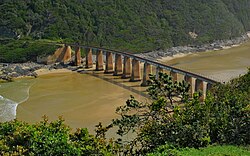
in Africa, crossed this bridge until the line was closed due to landslides in 2006.
273:
269:
182:
134:
124:
114:
34:
340:
177:
292:
224:
211:
332:
309:
281:
481:
308:
313:
Ox-wagon crossing the
Kaaimans River in the late 19th century
280:. Further upriver, the Kaaimans River Gorge is popular for
477:
Southern
African Mountain Passes - Kaaimans River Pass
240:
201:
188:
176:
160:
149:
140:
130:
120:
110:
105:
97:
77:
23:
39:Tide coming up the estuary of the Kaaimans River
335:at its mouth is crossed by a rail bridge. The
8:
424:Dictionary of Southern African Place Names
416:
350:
16:River in the Western Cape, South Africa
93:which was formerly found in the river.
61:
20:
7:
69:Location of the Kaaimans River mouth
276:. The mouth of the river lies near
472:Wilderness’s Kaaimans river rescue
14:
381:
365:
353:
60:
53:
33:
435:Kaaimans River Mouth Wilderness
482:Kaaimans River - Accommodation
400:List of rivers of South Africa
203: • coordinates
1:
141:Physical characteristics
291:The nearest large towns are
242: • elevation
376:crossing the Kaaimans River
190: • location
162: • location
513:
497:Rivers of the Western Cape
172:
145:
48:
44:
32:
326:Thomas Charles John Bain
196:Wilderness, Western Cape
360:Map of Africa viewpoint
314:
261:
339:, the last passenger
312:
225:33.99778°S 22.55694°E
405:Kaaimans Rivier Pass
388:Kaaimans River mouth
268:, is a river in the
246:0 m (0 ft)
337:Outeniqua Choo Tjoe
286:whitewater kayaking
230:-33.99778; 22.55694
221: /
167:Outeniqua Mountains
315:
322:Seven Passes Road
264:), also known as
250:
249:
504:
459:
454:
448:
443:
437:
432:
426:
421:
385:
369:
357:
236:
235:
233:
232:
231:
226:
222:
219:
218:
217:
214:
163:
64:
63:
57:
37:
21:
512:
511:
507:
506:
505:
503:
502:
501:
487:
486:
468:
463:
462:
455:
451:
444:
440:
433:
429:
422:
418:
413:
396:
389:
386:
377:
370:
361:
358:
349:
317:
316:
305:
243:
229:
227:
223:
220:
215:
212:
210:
208:
207:
204:
191:
161:
89:, a species of
73:
72:
71:
70:
67:
66:
65:
40:
28:
25:
17:
12:
11:
5:
510:
508:
500:
499:
489:
488:
485:
484:
479:
474:
467:
466:External links
464:
461:
460:
457:Idille History
449:
438:
427:
415:
414:
412:
409:
408:
407:
402:
395:
392:
391:
390:
387:
380:
378:
371:
364:
362:
359:
352:
348:
345:
307:
306:
304:
301:
262:Kaaimansrivier
254:Kaaimans River
248:
247:
244:
241:
238:
237:
205:
202:
199:
198:
192:
189:
186:
185:
180:
174:
173:
170:
169:
164:
158:
157:
151:
147:
146:
143:
142:
138:
137:
132:
128:
127:
122:
118:
117:
112:
108:
107:
103:
102:
99:
95:
94:
91:Monitor Lizard
79:
75:
74:
68:
59:
58:
52:
51:
50:
49:
46:
45:
42:
41:
38:
30:
29:
27:Kaaimansrivier
26:
24:Kaaimasn River
15:
13:
10:
9:
6:
4:
3:
2:
509:
498:
495:
494:
492:
483:
480:
478:
475:
473:
470:
469:
465:
458:
453:
450:
447:
442:
439:
436:
431:
428:
425:
420:
417:
410:
406:
403:
401:
398:
397:
393:
384:
379:
375:
368:
363:
356:
351:
346:
344:
342:
338:
334:
329:
327:
324:was built by
323:
311:
302:
300:
298:
294:
289:
287:
283:
279:
275:
271:
267:
263:
259:
255:
245:
239:
234:
206:
200:
197:
193:
187:
184:
181:
179:
175:
171:
168:
165:
159:
156:
152:
148:
144:
139:
136:
133:
129:
126:
123:
119:
116:
113:
109:
104:
100:
96:
92:
88:
84:
80:
76:
56:
47:
43:
36:
31:
22:
19:
452:
441:
430:
419:
330:
318:
290:
274:South Africa
270:Western Cape
266:Keerom River
265:
253:
251:
183:Indian Ocean
135:Garden Route
125:Western Cape
115:South Africa
101:Keeromrivier
86:
82:
18:
446:River Gorge
341:steam train
228: /
98:Nickname(s)
411:References
331:The tidal
293:Mossel Bay
278:Wilderness
216:22°33′25″E
213:33°59′52″S
258:Afrikaans
78:Etymology
491:Category
394:See also
121:Province
106:Location
347:Gallery
333:estuary
303:History
111:Country
87:leguaan
83:kaaiman
297:George
282:hiking
155:George
150:Source
131:Region
85:after
81:Named
194:W of
178:Mouth
153:N of
372:The
295:and
284:and
252:The
493::
374:N2
328:.
299:.
288:.
272:,
260::
256:(
Text is available under the Creative Commons Attribution-ShareAlike License. Additional terms may apply.