17:
25:
166:
in length and 6 feet in depth. During the first decade, less than 400 ships and barges, and some 4,000 rowing boats annually found use for it. The remain of the watercourse was
93:(formerly Karlbergsbron), offering a maximum vertical clearance of 5.1 m, is over-shadowed by the forest of massive concrete pillars and wide roadways of the
126:
174:
was replaced until 1909 by a new steel swing bridge, still operated manually until finally replaced by a static concrete bridge in the 1950s.
100:
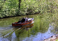
Karlbergskanalen is surrounded by trees and green spaces. Much of the character of the northern shore is dependent of the park of the nearby
327:
170:
during the 1840s and the entire canal subsequently deepened during the 1860s to between 2.97–5.94 metres. The first primitive
253:
70:
and thus forms the westernmost part of the nameless body of water which separates
Kungsholmen from the northern city districts
347:
284:
302:
342:
104:
and the recreational space surrounding it. Along the southern shore is a walk continuing all the way to the
183:
71:
105:
67:
63:
59:
16:
113:
36:
101:
249:
24:
336:
269:
171:
94:
90:
79:
83:
55:
109:
141:
128:
44:
306:
167:
117:
75:
285:"Vattenprogram för Stockholm 2000 - Karlbergskanalen — Klara Sjö"
108:
more than 2 km away. Parts of the residential buildings in the
48:
40:
163:
97:
motorway passing high above the idyllic rural scenery below.
116:
and a few older buildings, including the small but charming
305:(in Swedish). Karlbergs-Bros Koloniförening. Archived from
162:
Originally dug in 1832–1833, the canal was made 600
89:
Two bridges are stretching over the canal: Modest in size
270:"Karlbergskanalen: Från Ulvsundasjön till Karlbergssjön"
120:
palace originally built as a private residence in 1849.
112:
district is located next to the canal together with
328:
Stockholmskällan - Aerial image of the area in 1898
8:
303:"Karlbergs-Bros Koloniförening - Historia"
78:; the other sections being Karlbergssjön,
250:"Fasta broar i Stockholm och skärgården"
23:
15:
195:
7:
14:
20:Karlbergskanalen in February 2006
254:Swedish Maritime Administration
58:from the northern municipality
290:(in Swedish). Stockholm Vatten
39:for "Canal of Karlberg") is a
1:
268:Arnholm, Bosse (2004-08-10).
252:(in Swedish). Sjöfartverket (
28:Karlbergskanalen in May 2006
364:
217:, Stockholm Vatten, p 20.3
54:Separating the island of
184:Geography of Stockholm
29:
21:
348:Canals opened in 1833
142:59.34000°N 18.14778°E
27:
19:
138: /
106:Stockholm City Hall
43:in western central
147:59.34000; 18.14778
30:
22:
123:Coordinates are:
114:allotment gardens
355:
343:Canals in Sweden
317:
315:
314:
298:
296:
295:
289:
280:
278:
277:
264:
262:
261:
236:
233:
227:
224:
218:
212:
206:
205:, Sjöfartsverket
200:
153:
152:
150:
149:
148:
143:
139:
136:
135:
134:
131:
33:Karlbergskanalen
363:
362:
358:
357:
356:
354:
353:
352:
333:
332:
324:
312:
310:
301:
293:
291:
287:
283:
275:
273:
267:
259:
257:
248:
245:
240:
239:
234:
230:
225:
221:
213:
209:
201:
197:
192:
180:
160:
146:
144:
140:
137:
132:
129:
127:
125:
124:
102:Karlberg Palace
12:
11:
5:
361:
359:
351:
350:
345:
335:
334:
331:
330:
323:
322:External links
320:
319:
318:
299:
281:
265:
244:
241:
238:
237:
228:
219:
207:
194:
193:
191:
188:
187:
186:
179:
176:
159:
156:
62:, it connects
13:
10:
9:
6:
4:
3:
2:
360:
349:
346:
344:
341:
340:
338:
329:
326:
325:
321:
309:on 2011-10-02
308:
304:
300:
286:
282:
271:
266:
256:). 2007-11-06
255:
251:
247:
246:
242:
235:Karlbergs-Bro
232:
229:
223:
220:
216:
215:Vattenprogram
211:
208:
204:
199:
196:
189:
185:
182:
181:
177:
175:
173:
169:
165:
157:
155:
151:
121:
119:
115:
111:
107:
103:
98:
96:
92:
87:
85:
81:
77:
73:
69:
68:Karlbergssjön
65:
61:
57:
52:
50:
46:
42:
38:
34:
26:
18:
311:. Retrieved
307:the original
292:. Retrieved
274:. Retrieved
272:(in Swedish)
258:. Retrieved
231:
222:
214:
210:
202:
198:
172:swing bridge
161:
122:
99:
95:Essingeleden
91:Ekelundsbron
88:
80:Barnhusviken
64:Ulvsundasjön
53:
32:
31:
203:Fasta broar
145: /
56:Kungsholmen
337:Categories
313:2008-01-04
294:2008-01-04
276:2008-01-04
260:2008-01-04
243:References
133:18°08′52″E
130:59°20′24″N
110:Stadshagen
72:Vasastaden
84:Klara Sjö
45:Stockholm
178:See also
118:Mariedal
76:Norrmalm
226:Arnholm
168:dredged
158:History
37:Swedish
82:, and
49:Sweden
288:(PDF)
190:Notes
60:Solna
41:canal
74:and
164:ell
66:to
339::
154:.
86:.
51:.
47:,
316:.
297:.
279:.
263:.
35:(
Text is available under the Creative Commons Attribution-ShareAlike License. Additional terms may apply.