60:
52:
44:
116:
usually form gentle to moderate slopes. However, the
Kentucky River Fault system, part of which runs along the Palisades, provides another controlling factor. Movement along the fault has been largely vertical. Strata on the north side of the fault were raised several hundred feet relative to those
117:
on the south side. The thick dolomites and limestones of the High Bridge Group (Tyrone, Oregon, and Camp Nelson formations) are resistant to erosion and tend to be cliff-forming. As downward erosion hit the Camp Nelson Group rocks, meander-shaped cliffs were formed.
289:
297:
234:
275:
announced the purchase of 90 acres (360,000 m) adjacent to Tom Dorman State Nature
Preserve for the creation of the new Palisades State Park.
341:
255:
265:
336:
229:
196:(Aesculus octandra). Sites on old sandy river terraces and bluff-top ridges have more acid or infertile soils and harbor
239:
260:
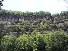
168:
species. The steep cliffs surrounding the
Kentucky River harbor the largest concentration of forest within the
245:
250:
112:, which covers most of this area, is composed of interbedded shales and thin limestones. Erosion of these
145:, soil, and tree composition are different from the surrounding rolling plains. The display of spring
59:
272:
189:
109:
158:
122:
101:
77:
184:(Acer saccharum) are abundant on the steep limestone slopes, along with less common trees like
197:
150:
85:
205:
169:
134:
105:
51:
284:
146:
43:
193:
177:
29:
330:
149:
is especially extravagant due to the rich limestone soils. The deep cliffs provide a
37:
201:
118:
28:
outcroppings that stretch for approximately 100 mi (160 km), along the
213:
181:
64:
142:
89:
312:
299:
209:
138:
113:
93:
81:
25:
217:
185:
173:
33:
154:
88:, base level lowered and the meander-form river eroded downward into
21:
125:
was sited close to the fault and the eastern end of the
Palisades.
165:
97:
58:
50:
42:
161:
208:
Other uncommon woody species found in the
Palisades include
80:. The meanders originally formed on the Lexington
204:(Liriodendron tulipifera) trees more common in
76:The Kentucky River Palisades is a cliff-lined
55:Vantage point from Tom Dorman Nature Preserve
8:
290:Nature Conservancy: Kentucky River Palisades
285:Kentucky River Palisades: Hope or Illusion?
172:, which is otherwise developed or cleared.
164:as well as several rare and endangered
67:layers of the Kentucky River Palisades
7:
230:Clyde E. Buckley Wildlife Sanctuary
84:. As sea-level lowered during the
47:The Kentucky River Palisades, 2008
14:
266:Tom Dorman State Nature Preserve
133:The Palisades are considered by
20:are a series of steep, scenic
1:
180:(Quercus muehlenbergii) and
342:Cliffs of the United States
358:
176:(Fraxinus quadrangulata),
235:Crutcher and Sally Brown
18:Kentucky River Palisades
216:, and various types of
192:(Cladrastis lutea) and
68:
56:
48:
337:Landforms of Kentucky
242:(by guided hike only)
206:Appalachian Kentucky.
147:ephemeral wildflowers
62:
54:
46:
273:Kentucky State Parks
256:Lower Howard's Creek
309: /
141:in the region. Its
110:Lexington Limestone
123:Fort Boonesborough
78:entrenched meander
69:
57:
49:
313:37.765°N 84.627°W
188:(Ulmus thomasi),
137:to form a unique
135:environmentalists
86:Quaternary Period
349:
324:
323:
321:
320:
319:
314:
310:
307:
306:
305:
302:
224:Nature Preserves
106:Bluegrass Region
357:
356:
352:
351:
350:
348:
347:
346:
327:
326:
318:37.765; -84.627
317:
315:
311:
308:
303:
300:
298:
296:
295:
281:
226:
170:Inner Bluegrass
131:
104:in the Central
74:
12:
11:
5:
355:
353:
345:
344:
339:
329:
328:
293:
292:
287:
280:
279:External links
277:
269:
268:
263:
258:
253:
248:
243:
237:
232:
225:
222:
194:yellow buckeye
178:chinquapin oak
130:
127:
73:
70:
30:Kentucky River
13:
10:
9:
6:
4:
3:
2:
354:
343:
340:
338:
335:
334:
332:
325:
322:
291:
288:
286:
283:
282:
278:
276:
274:
267:
264:
262:
259:
257:
254:
252:
249:
247:
244:
241:
238:
236:
233:
231:
228:
227:
223:
221:
219:
215:
211:
207:
203:
199:
195:
191:
187:
183:
179:
175:
171:
167:
163:
160:
156:
152:
148:
144:
140:
136:
128:
126:
124:
120:
115:
111:
107:
103:
99:
95:
91:
87:
83:
79:
71:
66:
61:
53:
45:
41:
39:
38:United States
35:
31:
27:
23:
19:
294:
271:In 2007 the
270:
202:tulip poplar
200:(Fagus) and
132:
119:Daniel Boone
75:
63:Close up of
17:
15:
316: /
214:Chokecherry
182:sugar maple
114:lithologies
65:sedimentary
32:in central
331:Categories
304:84°37′37″W
301:37°45′54″N
240:Floracliff
190:yellowwood
159:endangered
143:topography
94:limestones
90:Ordovician
261:Raven Run
218:Viburnums
210:Paxistima
153:for four
139:ecosystem
102:dolomites
82:Peneplain
26:limestone
246:Jim Beam
186:rock elm
174:Blue ash
34:Kentucky
155:species
151:habitat
129:Ecology
72:Geology
36:in the
251:Dupree
108:. The
100:, and
98:shales
22:gorges
198:beech
166:plant
92:-age
162:bats
24:and
16:The
157:of
121:'s
333::
220:.
212:,
96:,
40:.
Text is available under the Creative Commons Attribution-ShareAlike License. Additional terms may apply.