76:
83:
54:
218:
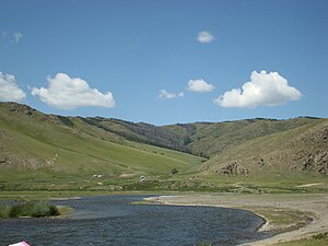
on the eastern slope, following the Orkhon River. The Tuin River flows south from the western sector of the park, and the
Khuisiin Naiman Nuur ("Eight Lakes") Nature Reserve is carved out of the south-central area. Elevations range from 1,700–2,700 metres (5,600–8,900 ft). The mountaintops
263:
The relatively flat steppe valley floor is steppe, with riparian forest along the rivers and streams. The higher slopes are generally forested with larch, pine and mixed forests. There are alpine meadows at the highest elevations. Endangered species in the park include the Pallas's fish eagle
459:
514:
539:
75:
600:
452:
334:
534:
240:). This climate is characteristic of steppe climates intermediary between desert humid climates, and typically have precipitation is above
114:
595:
569:
445:
484:
468:
289:
489:
385:
234:
248:
559:
479:
39:
564:
549:
312:
252:
494:
206:
valley. There are a variety of habitat types in the park: steppe, riparian forests, larch taiga, and alpine meadows.
509:
590:
524:
499:
554:
277:
265:
504:
273:
529:
241:
191:
27:
432:
237:
229:
199:
158:
360:
584:
544:
269:
43:
203:
58:
162:
215:
214:
The park is over 200 km from the western foothills of the
Khangai to the
62:
437:
129:
116:
102:
53:
150:
407:
335:"Assessment Report - Strategic Planning for Peatlands in Mongolia"
359:
Kottek, M.; Grieser, J.; Beck, C.; Rudolf, B.; Rubel, F. (2006).
251:
ecoregion. The eastern half, along the Orkhon River, is in the
154:
441:
433:
Park borders, Khangain Nuruu
National Park, ProtectedPlanet.net
244:. At least one month averages below 0 °C (32 °F).
198:) stretches in a west-to-east band across the middle of the
361:"World Map of Koppen-Geiger Climate Classification Updated"
181:
Ministry of
Environment and Green Development of Mongolia
177:
169:
145:
108:
98:
82:
21:
219:are rounded, with bare rock at upper elevations.
453:
307:
305:
8:
202:, with the eastern half following the upper
460:
446:
438:
386:"Dataset - Koppen climate classifications"
18:
301:
247:The western half of the park is in the
7:
97:
290:List of national parks of Mongolia
14:
601:Important Bird Areas of Mongolia
272:). It has been recognised as an
81:
74:
52:
249:Khangai Mountains alpine meadow
168:
313:"Khangain Nuruu National Park"
1:
235:Köppen climate classification
540:Khorgo-Terkhiin Tsagaan Nuur
253:Selenge-Orkhon forest steppe
366:. Gebrüder Borntraeger 2006
227:The climate of the area is
188:Khangai Nuruu National Park
22:Khangai Nuruu National Park
617:
596:National parks of Mongolia
469:National parks of Mongolia
268:) and the Saker's Falcon (
475:
410:. Resolve, using WWF data
195:
69:
51:
37:
31:
26:
16:National park in Mongolia
408:"Map of Ecoregions 2017"
315:. Birdlife International
340:. Asia Development Bank
278:BirdLife International
266:Haliaeetus leucoryphus
230:Cold semi-arid climate
570:Ulaagchinii Khar Nuur
223:Climate and ecoregion
485:Bulgan Gol-Ikh Ongog
274:Important Bird Area
178:Governing body
126: /
490:Gobi Gurvansaikhan
242:evapotranspiration
578:
577:
200:Khangai Mountains
185:
184:
608:
591:IUCN Category II
560:Tarvagatai Nuruu
480:Altai Tavan Bogd
462:
455:
448:
439:
420:
419:
417:
415:
404:
398:
397:
395:
393:
382:
376:
375:
373:
371:
365:
356:
350:
349:
347:
345:
339:
331:
325:
324:
322:
320:
309:
197:
141:
140:
138:
137:
136:
131:
127:
124:
123:
122:
119:
90:Location of Park
85:
84:
78:
56:
33:
19:
616:
615:
611:
610:
609:
607:
606:
605:
581:
580:
579:
574:
565:Tsambagarav Uul
471:
466:
429:
424:
423:
413:
411:
406:
405:
401:
391:
389:
384:
383:
379:
369:
367:
363:
358:
357:
353:
343:
341:
337:
333:
332:
328:
318:
316:
311:
310:
303:
298:
286:
261:
259:Flora and fauna
225:
212:
134:
132:
128:
125:
120:
117:
115:
113:
112:
94:
93:
92:
91:
88:
87:
86:
65:
47:
17:
12:
11:
5:
614:
612:
604:
603:
598:
593:
583:
582:
576:
575:
573:
572:
567:
562:
557:
552:
550:Munkhkhairkhan
547:
542:
537:
532:
527:
522:
517:
512:
507:
502:
497:
492:
487:
482:
476:
473:
472:
467:
465:
464:
457:
450:
442:
436:
435:
428:
427:External links
425:
422:
421:
399:
377:
351:
326:
300:
299:
297:
294:
293:
292:
285:
282:
260:
257:
224:
221:
211:
208:
183:
182:
179:
175:
174:
171:
167:
166:
147:
143:
142:
130:47.2°N 101.4°E
110:
106:
105:
100:
96:
95:
89:
80:
79:
73:
72:
71:
70:
67:
66:
57:
49:
48:
38:
35:
34:
24:
23:
15:
13:
10:
9:
6:
4:
3:
2:
613:
602:
599:
597:
594:
592:
589:
588:
586:
571:
568:
566:
563:
561:
558:
556:
553:
551:
548:
546:
545:Khyargas Nuur
543:
541:
538:
536:
533:
531:
530:Lake Khövsgöl
528:
526:
523:
521:
520:Khangai Nuruu
518:
516:
513:
511:
508:
506:
503:
501:
498:
496:
495:Gorkhi-Terelj
493:
491:
488:
486:
483:
481:
478:
477:
474:
470:
463:
458:
456:
451:
449:
444:
443:
440:
434:
431:
430:
426:
414:September 14,
409:
403:
400:
392:September 14,
387:
381:
378:
370:September 14,
362:
355:
352:
336:
330:
327:
314:
308:
306:
302:
295:
291:
288:
287:
283:
281:
279:
275:
271:
270:Falco cherrug
267:
258:
256:
254:
250:
245:
243:
239:
236:
232:
231:
222:
220:
217:
209:
207:
205:
201:
196:Хангайн нуруу
193:
189:
180:
176:
172:
164:
161:; 3,431
160:
157:; 8,885
156:
152:
148:
144:
139:
111:
107:
104:
101:
77:
68:
64:
60:
55:
50:
45:
44:national park
41:
40:IUCN category
36:
32:Хангайн нуруу
29:
25:
20:
535:Khan Khentii
519:
510:Khar-Us Nuur
412:. Retrieved
402:
390:. Retrieved
388:. World Bank
380:
368:. Retrieved
354:
342:. Retrieved
329:
317:. Retrieved
262:
246:
228:
226:
213:
204:Orkhon River
187:
186:
59:Orkhon River
525:Khogno Khan
515:Khan-Khokhi
255:ecoregion.
170:Established
153:(2,195,531
135:47.2; 101.4
133: /
109:Coordinates
585:Categories
500:Gun-Galuut
296:References
216:Kharkhorin
210:Topography
163:sq mi
63:Kharkhorin
555:Onon-Balj
344:April 18,
319:April 18,
192:Mongolian
28:Mongolian
284:See also
151:hectares
149:888,500
121:101°24′E
103:Mongolia
99:Location
118:47°12′N
505:Hustai
364:(PDF)
338:(PDF)
238:(BSk)
155:acres
61:near
416:2019
394:2019
372:2019
346:2020
321:2020
173:1996
146:Area
42:II (
276:by
587::
304:^
280:.
194::
159:km
30::
461:e
454:t
447:v
418:.
396:.
374:.
348:.
323:.
264:(
233:(
190:(
165:)
46:)
Text is available under the Creative Commons Attribution-ShareAlike License. Additional terms may apply.