297:
274:
140:
259:
286:
243:
34:
564:
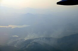
are deliberately set off by local farmers in the mountain forests of the Khun Tan Range every year between
February and April towards the end of the dry season. One of the purposes of this somewhat radical activity is to trigger the growth of the
296:
590:
Although the large trees are not too badly affected, the periodic fires negatively affect the wildlife of vast areas of the mountain chain. These yearly wildfires are the main cause of the intense
1261:
583:) that fetches a high price on the Thai market. Often speculators hire people to set forests on fire in order to claim land title deeds for the areas that have become "
1053:
437:. Temperatures range from a maximum of 33°C in the hot season (February to July), to a minimum of 2°C during the cold season, between November and January.
1306:
1301:
1316:
1311:
79:
952:
1291:
541:
between Chiang Mai and Chiang Rai cuts diagonally across the Khun Tan Range from SW to NE about 30 km northeast of Chiang Mai town.
1134:
935:
1001:
892:
1185:
983:
804:
1028:
852:
908:
476:
was built in 1907 across the southern part of the range and contributed to alleviate the difficulties in communication between
1120:
363:
further east and some scholarly works designate the Khun Tan as the "Western Phi Pan Nam Range", including it as part of the
1161:
713:
deserve mention. The Khun Tan mountains also act as a natural barrier for species west and east of the range, such as the
670:
1266:
72:
1236:
1251:
1296:
1057:
760:
1321:
857:
780:
816:
741:
614:
Many species of mammals are assumed to have disappeared in the range for lack of recent sightings, such as the
501:
606:
of the woods. The dry forest soil leads to lower water intake for the trees to extract when the rains arrive.
1149:
387:. It stretches southwards in a north/south direction turning midway to a roughly NE/SW direction between the
1286:
770:
690:
344:
842:
775:
765:
706:
674:
550:
289:
682:
538:
512:
466:
423:
504:, located at the northern end of the tunnel, is the highest railway station in Thailand at 758 m above
702:
694:
599:
442:
273:
623:
329:
325:
205:
171:
167:
139:
1109:
408:
960:
698:
615:
412:
404:
217:
1016:
595:
567:
446:
430:
364:
360:
321:
193:
1131:
932:
721:
554:
488:
and it took eleven years to complete. Construction was disrupted owing to the arrest of the
396:
337:
333:
258:
179:
175:
39:
998:
889:
1189:
1182:
1138:
1005:
987:
980:
939:
896:
822:
666:
651:
584:
473:
458:
301:
403:(ดอยแม่โถ), also known as Doi Langka Luang (ดอยลังกาหลวง); Other peaks are 2,012 m high
1032:
847:
812:
753:
710:
678:
524:
497:
449:
areas of the range in 1955, a very rare event in these latitudes despite the altitude.
380:
343:
The geological composition of the Khun Tan mountains is different from the neighboring
320:
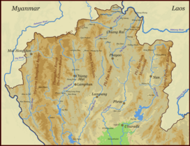
or, erroneously, ทิวเขาขุนตาล) is a mountain range that occupies a central position in
186:
145:
285:
242:
1280:
1094:
729:
714:
591:
572:
489:
462:
384:
313:
1169:
912:
1183:
Aseanbiodiversity - The
Occurrence of the Pied Stonechat in Eastern and SE Thailand
826:
643:
427:
292:
NE of Chiang Mai with the Khun Tan Range in the background and a seasonal wildfire
1256:
1246:
1228:
535:
and some of these communities are regularly visited by organized tourist groups.
1241:
662:
639:
627:
603:
528:
520:
493:
400:
348:
278:
55:
1271:
1029:"The White Bridge: Celebrating the 80th birthday of His Majesty King Bhumibol"
909:"Geology of Thailand - Ministry of Natural Resources and Environment, Bangkok"
800:
749:
725:
647:
619:
523:
who have villages in the mountain sides of the northern areas of the range in
516:
481:
434:
392:
388:
352:
251:
247:
94:
81:
808:
796:
505:
416:
376:
234:
745:
561:
557:
grows above 800 m, as well as in shady and narrow zones in the valleys.
485:
262:
Aerial view of yearly deliberate wildfires on the Khun Tan Range between
226:
210:
157:
1090:
33:
477:
356:
267:
263:
222:
1200:
351:
rocks are absent in this mountain chain which is thus not part of the
686:
62:
496:
when Siam, having been neutral until July 1917, declared war on the
304:. The haze caused by wildfire smoke is common during the dry season.
830:
635:
631:
532:
230:
281:
village of
Maejantai lies deep in the heart of the Khun Tan range
792:
438:
655:
833:
of the place nicknamed "Crazy Horse
Buttress" in the Range.
1267:
Shrine of the
Guardian of the Mountains (ศาลเจ้าพ่อขุนตาน)
1121:
Bangkok Post - PM misses the boat again on northern haze
880:มหาวิทยาลัยราชภัฏสวนดุสิต พ.ศ. 2528 (ปรับปรุง พ.ศ. 2549)
1237:
Chiang Mai’s Best Kept Secret - Khun Tan
National Park
419:(ดอยสะเก็ด), also known as Doi Khun On (ดอยขุนออน).
1272:
Rapid 102 by ALS - 4119 On Khun Tan
Mountain Range 2
1110:
The
Politics of Ethnic Tourism in Northern Thailand
515:communities living in the Khun Tan Range, like the
216:
204:
199:
185:
163:
153:
131:
123:
115:
110:
71:
61:
51:
46:
21:
791:Tourist attractions of the Khun Tan Range include
634:. Animals that have been sighted recently include
457:Historically the Khun Tan Range was a formidable
347:in the west and the Daen Lao Range in the north.
1079:The Railway Atlas of Thailand, Laos and Cambodia
825:east of Chiang Mai is a popular destination for
811:of the range. It is an institute taking care of
1213:A Guide to Rock Climbing in Northern Thailand.
359:of the Khun Tan Range is homogeneous with the
8:
1211:Joshua Morris & Khaetthaleeya Uppakham,
1215:Nopburee Press Co., Ltd. Chiang Mai, 2004.
1054:"The Beginning of the Railway in Thailand"
18:
549:The lower altitudes are covered with dry
1231:The Physical Geography of Southeast Asia
1201:Thai Elephant Conservation Center (TECC)
1093:จากเว็บไซต์สำนักงานสรรพากรพื้นที่ลำพูน]
422:Along with the westernmost range of the
295:
284:
272:
257:
241:
1150:National Forest Policy Review- Thailand
869:
752:, is located in Mae On District. Other
375:The Khun Tan Range begins south of the
815:since 1993 under the patronage of the
484:. It is the longest railway tunnel in
426:further east this range separates the
7:
1162:"Underlying Causes of Deforestation"
756:in the Khun Tan mountain chain are:
531:are refugees from troubled areas in
1252:Chiang Mai Rock Climbing Adventures
399:. The tallest peak is 2,031 m high
379:valley, at the southern end of the
1242:Chae Sawn (Chae Son) National Park
720:Reptiles in the range include the
324:. Most of the range is located in
14:
805:Thai Elephant Conservation Center
246:The Khun Tan Range rising beyond
119:260 km (160 mi) N/S
1307:Geography of Chiang Rai province
1302:Geography of Chiang Mai province
853:Environmental issues in Thailand
829:who wish to climb the limestone
748:(น้ำแม่ออน), a tributary of the
138:
32:
433:and plateaus of Chiang Mai and
254:on the other side of the valley
127:50 km (31 mi) E/W
999:Heritage Thailand, Geography 4
38:View of the Khun Tan Range in
1:
1317:Geography of Lampang province
1312:Geography of Lamphun province
1166:UN Secretary-General’s Report
744:protecting the source of the
671:grey-headed canary-flycatcher
1081:, White Lotus, Bangkok, 2010
67:2,031 m (6,663 ft)
1292:Mountain ranges of Thailand
878:ภูมิศาสตร์การท่องเที่ยวไทย.
807:is located in the southern
781:Doi Wiang Pha National Park
602:by completely denuding the
365:Phi Pan Nam Mountain System
1338:
761:Doi Khun Tan National Park
411:(ดอยขุนตาน), 1,668 m high
16:Mountain range in Thailand
1247:Mae Ta Krai National Park
1098:
858:Deforestation in Thailand
742:Mae Ta Krai National Park
576:
407:(ดอยผาจ้อ), 1,348 m high
317:
136:
31:
26:
1132:Mushroom Research Center
817:Royal Family of Thailand
1257:Khun Chae National Park
981:Khun Chae National Park
953:"Sarasawadee Ongsakul,
771:Khun Chae National Park
691:velvet-fronted nuthatch
345:Thanon Thong Chai Range
876:ผศ.นงรัตน์ พยัคฆันตร.
843:Western Forest Complex
776:Si Lanna National Park
766:Chae Son National Park
707:brown-cheeked fulvetta
675:white-crowned forktail
598:and contribute to the
551:mixed deciduous forest
305:
293:
282:
270:
255:
683:crested serpent eagle
661:Among the birds, the
600:floods in the country
467:Central Plain of Siam
424:Phi Pan Nam Mountains
299:
288:
276:
261:
245:
95:19.08333°N 99.34167°E
1091:อุโมงค์รถไฟถ้ำขุนตาน
955:The History of Lanna
703:blue-winged leafbird
695:blue-throated barbet
624:white-handed gibbon
290:Mae Kuang Reservoir
91: /
1188:2016-03-04 at the
1137:2012-01-27 at the
1004:2011-10-07 at the
986:2010-09-22 at the
938:2012-03-10 at the
895:2012-01-28 at the
699:coppersmith barbet
616:Asiatic black bear
539:Thailand Route 118
511:There are certain
306:
294:
283:
271:
256:
100:19.08333; 99.34167
47:Highest point
1297:Phi Pan Nam Range
890:Northern Thailand
596:Northern Thailand
568:Astraeus odoratus
447:Mae Suai District
415:and 1,816 m high
361:Phi Pan Nam Range
338:Lamphun Provinces
322:Northern Thailand
240:
239:
194:Phi Pan Nam Range
1329:
1322:Wildfire ecology
1216:
1209:
1203:
1198:
1192:
1180:
1174:
1173:
1168:. Archived from
1158:
1152:
1147:
1141:
1129:
1123:
1118:
1112:
1107:
1101:
1100:
1088:
1082:
1075:
1069:
1068:
1066:
1065:
1056:. Archived from
1050:
1044:
1043:
1041:
1040:
1031:. Archived from
1025:
1019:
1017:Snow in Thailand
1014:
1008:
996:
990:
978:
972:
971:
969:
968:
959:. Archived from
949:
943:
930:
924:
923:
921:
920:
911:. Archived from
905:
899:
887:
881:
874:
722:green tree viper
652:flying squirrels
578:
555:evergreen forest
502:Khun Tan Station
397:Doi Tao District
319:
300:Entrance to the
189:
142:
106:
105:
103:
102:
101:
96:
92:
89:
88:
87:
84:
40:Mae Lao District
36:
19:
1337:
1336:
1332:
1331:
1330:
1328:
1327:
1326:
1277:
1276:
1225:
1220:
1219:
1210:
1206:
1199:
1195:
1190:Wayback Machine
1181:
1177:
1160:
1159:
1155:
1148:
1144:
1139:Wayback Machine
1130:
1126:
1119:
1115:
1108:
1104:
1089:
1085:
1077:Brendan Whyte,
1076:
1072:
1063:
1061:
1052:
1051:
1047:
1038:
1036:
1027:
1026:
1022:
1015:
1011:
1006:Wayback Machine
997:
993:
988:Wayback Machine
979:
975:
966:
964:
951:
950:
946:
940:Wayback Machine
931:
927:
918:
916:
907:
906:
902:
897:Wayback Machine
888:
884:
875:
871:
866:
839:
823:Mae On District
789:
754:protected areas
738:
736:Protected areas
667:scarlet minivet
612:
585:degraded forest
547:
474:Khun Tan Tunnel
459:natural barrier
455:
373:
302:Khun Tan Tunnel
187:
149:
148:
99:
97:
93:
90:
85:
82:
80:
78:
77:
42:
17:
12:
11:
5:
1335:
1333:
1325:
1324:
1319:
1314:
1309:
1304:
1299:
1294:
1289:
1287:Khun Tan Range
1279:
1278:
1275:
1274:
1269:
1264:
1259:
1254:
1249:
1244:
1239:
1234:
1229:Google Books,
1224:
1223:External links
1221:
1218:
1217:
1204:
1193:
1175:
1172:on 2001-04-11.
1153:
1142:
1124:
1113:
1102:
1083:
1070:
1045:
1020:
1009:
991:
973:
944:
933:ทิวเขาผีปันน้ำ
925:
900:
882:
868:
867:
865:
862:
861:
860:
855:
850:
848:Thai highlands
845:
838:
835:
788:
785:
784:
783:
778:
773:
768:
763:
737:
734:
711:red junglefowl
679:brown fish owl
611:
608:
546:
543:
527:. Part of the
525:Phrao District
498:Central Powers
454:
451:
381:Daen Lao Range
372:
369:
310:Khun Tan Range
238:
237:
220:
214:
213:
208:
202:
201:
197:
196:
191:
183:
182:
165:
161:
160:
155:
151:
150:
146:Thai highlands
143:
137:
134:
133:
129:
128:
125:
121:
120:
117:
113:
112:
108:
107:
75:
69:
68:
65:
59:
58:
53:
49:
48:
44:
43:
37:
29:
28:
24:
23:
22:Khun Tan Range
15:
13:
10:
9:
6:
4:
3:
2:
1334:
1323:
1320:
1318:
1315:
1313:
1310:
1308:
1305:
1303:
1300:
1298:
1295:
1293:
1290:
1288:
1285:
1284:
1282:
1273:
1270:
1268:
1265:
1263:
1260:
1258:
1255:
1253:
1250:
1248:
1245:
1243:
1240:
1238:
1235:
1233:
1232:
1227:
1226:
1222:
1214:
1208:
1205:
1202:
1197:
1194:
1191:
1187:
1184:
1179:
1176:
1171:
1167:
1163:
1157:
1154:
1151:
1146:
1143:
1140:
1136:
1133:
1128:
1125:
1122:
1117:
1114:
1111:
1106:
1103:
1096:
1092:
1087:
1084:
1080:
1074:
1071:
1060:on 2012-09-25
1059:
1055:
1049:
1046:
1035:on 2015-10-22
1034:
1030:
1024:
1021:
1018:
1013:
1010:
1007:
1003:
1000:
995:
992:
989:
985:
982:
977:
974:
963:on 2008-12-07
962:
958:
956:
948:
945:
941:
937:
934:
929:
926:
915:on 2017-12-01
914:
910:
904:
901:
898:
894:
891:
886:
883:
879:
873:
870:
863:
859:
856:
854:
851:
849:
846:
844:
841:
840:
836:
834:
832:
828:
827:rock climbers
824:
820:
818:
814:
810:
806:
802:
798:
794:
786:
782:
779:
777:
774:
772:
769:
767:
764:
762:
759:
758:
757:
755:
751:
747:
743:
735:
733:
731:
730:flying lizard
727:
723:
718:
716:
715:pied bushchat
712:
708:
704:
700:
696:
692:
688:
684:
680:
676:
672:
668:
664:
659:
657:
653:
649:
645:
641:
637:
633:
629:
625:
621:
617:
609:
607:
605:
601:
597:
593:
592:air pollution
588:
586:
582:
574:
570:
569:
563:
558:
556:
553:, while hill
552:
544:
542:
540:
536:
534:
530:
526:
522:
518:
514:
509:
507:
503:
499:
495:
492:engineers in
491:
487:
483:
479:
475:
470:
468:
464:
463:Lanna Kingdom
460:
452:
450:
448:
444:
440:
436:
432:
429:
425:
420:
418:
414:
410:
406:
402:
398:
394:
390:
386:
385:Fang District
382:
378:
370:
368:
366:
362:
358:
354:
350:
346:
341:
339:
335:
331:
327:
323:
315:
311:
303:
298:
291:
287:
280:
275:
269:
265:
260:
253:
249:
244:
236:
232:
228:
224:
221:
219:
215:
212:
209:
207:
203:
198:
195:
192:
190:
184:
181:
177:
173:
169:
166:
162:
159:
156:
152:
147:
141:
135:
130:
126:
122:
118:
114:
109:
104:
76:
74:
70:
66:
64:
60:
57:
54:
50:
45:
41:
35:
30:
25:
20:
1262:Railway Trip
1230:
1212:
1207:
1196:
1178:
1170:the original
1165:
1156:
1145:
1127:
1116:
1105:
1086:
1078:
1073:
1062:. Retrieved
1058:the original
1048:
1037:. Retrieved
1033:the original
1023:
1012:
994:
976:
965:. Retrieved
961:the original
954:
947:
928:
917:. Retrieved
913:the original
903:
885:
877:
872:
821:
799:and natural
790:
739:
719:
660:
644:barking deer
613:
589:
580:
566:
559:
548:
537:
510:
471:
461:between the
456:
441:fell in the
428:intermontane
421:
409:Doi Khun Tan
374:
355:system. The
342:
318:ทิวเขาขุนตาน
309:
307:
218:Type of rock
188:Parent range
27:ทิวเขาขุนตาน
801:hot springs
663:ashy drongo
648:hog badgers
628:leopard cat
604:undergrowth
529:hill people
494:World War I
443:Chai Prakan
413:Doi Mon Lan
405:Doi Pha Cho
401:Doi Mae Tho
349:Precambrian
206:Age of rock
144:Map of the
98: /
73:Coordinates
56:Doi Mae Tho
1281:Categories
1064:2012-01-21
1039:2012-01-20
967:2012-02-27
919:2012-01-20
864:References
797:waterfalls
750:Ping River
726:king cobra
620:slow loris
571:mushroom (
560:Extensive
513:Hill tribe
482:Chiang Mai
435:Chiang Rai
393:Wang River
389:Ping River
353:Shan Hills
330:Chiang Rai
328:, western
326:Chiang Mai
252:Doi Suthep
250:seen from
248:Chiang Mai
172:Chiang Rai
168:Chiang Mai
111:Dimensions
86:99°20′30″E
83:19°05′00″N
942:(in Thai)
813:elephants
809:foothills
640:wild pigs
562:wildfires
506:sea level
417:Doi Saket
377:Kok River
371:Geography
235:limestone
164:Provinces
132:Geography
63:Elevation
1186:Archived
1135:Archived
1002:Archived
984:Archived
936:Archived
893:Archived
837:See also
746:On River
728:and the
630:and the
610:Wildlife
577:เห็ดเผาะ
519:and the
486:Thailand
465:and the
391:and the
227:phyllite
211:Triassic
158:Thailand
1099:ภาษาไทย
787:Tourism
581:het pho
545:Ecology
478:Bangkok
453:History
357:geology
334:Lampang
268:Lampang
264:Lamphun
223:granite
200:Geology
180:Lamphun
176:Lampang
154:Country
831:cliffs
803:. The
724:, the
687:shikra
636:civets
626:, the
622:, the
618:, the
490:German
431:basins
395:until
116:Length
793:caves
632:serow
533:Burma
231:shale
124:Width
1095:Thai
740:The
709:and
656:bats
654:and
587:".
573:Thai
521:Akha
480:and
472:The
445:and
439:Snow
336:and
314:Thai
308:The
279:Akha
277:The
266:and
233:and
178:and
52:Peak
658:.
594:in
517:Yao
383:in
1283::
1164:.
1097::
819:.
795:,
732:.
717:.
705:,
701:,
697:,
693:,
689:,
685:,
681:,
677:,
673:,
669:,
665:,
650:,
646:,
642:,
638:,
579:;
575::
508:.
500:.
469:.
367:.
340:.
332:,
316::
229:,
225:,
174:,
170:,
1067:.
1042:.
970:.
957:"
922:.
312:(
Text is available under the Creative Commons Attribution-ShareAlike License. Additional terms may apply.