78:
26:
71:
267:
The
Amargosa unit in the north is centered around Amargosa Canyon and protects a desert wetland habitat that supports a diverse population of migratory birds and aquatic life. The central Kingston unit encompasses the Kingston Mountains themselves, a 17-mile ridgeline that rises to 7,323 on Kingston
239:
is about 22 miles (35 km) south of the
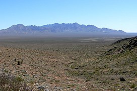
Kingston Range. The range stretches about 18 mi (29 km) in a northeast–southwest direction. Tecopa Pass, at 5,100 ft (1,600 m), is located at the northeastern end of the mountains.
449:
256:
by the U.S. Congress in 1994 and is currently composed of 252,149 acres in three distinct units separated by non-wilderness corridors. This area protects an ecological transition zone between the
439:
444:
146:
384:
253:
70:
375:
205:
132:
380:
287:
woodland at higher elevations, this desert wilderness includes a wealth of botanical biodiversity including the only stand of
236:
139:
232:
351:
217:
370:
312:
201:
295:
trees clinging to the slopes of two drainages just below
Kingston Peak. Wildlife includes the banded
25:
257:
228:
340:
316:
272:
178:
415:
433:
300:
276:
268:
Peak. The southern Shadow
Mountain unit covers the lower elevation Shadow Mountains.
261:
209:
122:
320:
296:
288:
403:
332:
284:
224:
324:
213:
91:
216:. The range reaches a height of 7,323 feet (2,232 m) above sea level at
161:
148:
336:
292:
280:
308:
49:
328:
304:
183:
291:
in the eastern Mojave Desert as well as a relic stand of
450:
Mountain ranges of San
Bernardino County, California
177:
138:
128:
118:
110:
102:
58:
48:
40:
35:
18:
426:California Road and Recreation Atlas, 2005, pg.97
8:
279:scrub vegetation in the lower elevations to
271:There are 505 native plant species in the
15:
385:United States Department of the Interior
362:
254:National Wilderness Preservation System
440:Mountain ranges of Southern California
339:, several species of lizards, and the
223:The range is located southeast of the
77:
7:
445:Mountain ranges of the Mojave Desert
376:Geographic Names Information System
14:
76:
69:
24:
381:United States Geological Survey
90:Location of Kingston Range in
1:
30:Kingston Range, Mojave Desert
162:35.78413889°N 115.90195806°W
54:7,323 ft (2,232 m)
466:
167:35.78413889; -115.90195806
416:Kingston Range Wilderness
404:Kingston Range Wilderness
250:Kingston Range Wilderness
235:. The small community of
186: Horse Thief Springs
63:
23:
313:black-tailed jackrabbits
196:, sometimes called the
133:San Bernardino County
406:- Wilderness Connect
227:, and north of the
158: /
198:Kingston Mountains
36:Highest point
252:was added to the
190:
189:
140:Range coordinates
457:
419:
413:
407:
401:
395:
394:
392:
391:
371:"Kingston Range"
367:
317:ground squirrels
237:Halloran Springs
229:Shadow Mountains
208:counties in the
200:, is located in
173:
172:
170:
169:
168:
163:
159:
156:
155:
154:
151:
80:
79:
73:
28:
16:
465:
464:
460:
459:
458:
456:
455:
454:
430:
429:
423:
422:
414:
410:
402:
398:
389:
387:
369:
368:
364:
359:
349:
341:desert tortoise
273:wilderness area
246:
166:
164:
160:
157:
152:
149:
147:
145:
144:
98:
97:
96:
95:
94:
88:
87:
86:
85:
81:
31:
12:
11:
5:
463:
461:
453:
452:
447:
442:
432:
431:
428:
427:
421:
420:
408:
396:
361:
360:
358:
355:
348:
345:
262:Mojave Deserts
245:
242:
206:San Bernardino
194:Kingston Range
188:
187:
181:
175:
174:
153:115°54′7.049″W
142:
136:
135:
130:
126:
125:
120:
116:
115:
112:
108:
107:
104:
100:
99:
89:
84:Kingston Range
83:
82:
75:
74:
68:
67:
66:
65:
64:
61:
60:
56:
55:
52:
46:
45:
42:
38:
37:
33:
32:
29:
21:
20:
19:Kingston Range
13:
10:
9:
6:
4:
3:
2:
462:
451:
448:
446:
443:
441:
438:
437:
435:
425:
424:
417:
412:
409:
405:
400:
397:
386:
382:
378:
377:
372:
366:
363:
356:
354:
353:
352:Kingston Peak
346:
344:
342:
338:
334:
330:
326:
322:
321:kangaroo rats
318:
314:
310:
306:
302:
301:bighorn sheep
298:
294:
290:
286:
282:
278:
277:Creosote bush
274:
269:
265:
263:
259:
255:
251:
243:
241:
238:
234:
233:Interstate 15
230:
226:
221:
219:
218:Kingston Peak
215:
211:
210:Mojave Desert
207:
203:
199:
195:
185:
182:
180:
176:
171:
150:35°47′2.900″N
143:
141:
137:
134:
131:
127:
124:
123:Mojave Desert
121:
117:
113:
109:
106:United States
105:
101:
93:
72:
62:
57:
53:
51:
47:
44:Kingston Peak
43:
39:
34:
27:
22:
17:
411:
399:
388:. Retrieved
374:
365:
350:
333:rattlesnakes
297:gila monster
289:Giant nolina
270:
266:
249:
247:
222:
197:
193:
191:
325:roadrunners
258:Great Basin
225:Nopah Range
212:in eastern
165: /
434:Categories
390:2009-05-04
357:References
337:tarantulas
244:Wilderness
214:California
114:California
92:California
293:white fir
59:Geography
50:Elevation
347:See also
179:Topo map
129:District
303:, wild
281:juniper
275:. From
103:Country
309:coyote
305:burros
285:pinyon
119:Region
418:- BLM
329:quail
111:State
260:and
248:The
231:and
204:and
202:Inyo
192:The
184:USGS
41:Peak
436::
383:,
379:.
373:.
343:.
335:,
331:,
327:,
323:,
319:,
315:,
311:,
307:,
299:,
264:.
220:.
393:.
283:-
Text is available under the Creative Commons Attribution-ShareAlike License. Additional terms may apply.