142:
182:
149:
175:
507:
29:
378:
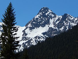
is significant as the summit rises 3,000 feet (910 meters) above Fisher Creek in one mile (1.6 km) and the northeast slope rises 3,400 feet (1,000 meters) above
Kitling Creek in 0.75 mile (1.2 km). The mountain's name "Kitling" derives from
419:), causing them to drop their moisture in the form of rain or snowfall onto the Cascades. As a result, the west side of the North Cascades experiences high precipitation, especially during the winter months in the form of snowfall. Because of
486:
period dating back over two million years ago, glaciation advancing and retreating repeatedly scoured the landscape leaving deposits of rock debris. The U-shaped cross section of the river valleys is a result of recent glaciation.
427:
danger. During winter months, weather is usually cloudy, but due to high pressure systems over the
Pacific Ocean that intensify during summer months, there is often little or no cloud cover during the summer.
639:
444:. Geological events occurring many years ago created the diverse topography and drastic elevation changes over the Cascade Range leading to the various climate differences.
737:
141:
97:
732:
671:
174:
757:
495:
in combination with glaciation have been the dominant processes which have created the tall peaks and deep valleys of the North
Cascades area.
624:
752:
662:
391:. The mountain takes its name from Kitling Lake which is one mile north of the peak. The toponym was officially adopted in 1969 by the
525:
667:
520:
273:
392:
339:
239:
90:
335:
243:
229:
657:
742:
616:
468:
331:
219:
747:
367:
67:
57:
34:
80:
411:
originating in the
Pacific Ocean travel northeast toward the Cascade Mountains. As fronts approach the
452:
464:
447:
The history of the formation of the
Cascade Mountains dates back millions of years ago to the late
717:
375:
342:. Kitling Peak is situated at the east end of Ragged Ridge. Other peaks on Ragged Ridge include
620:
404:
388:
359:
512:
492:
420:
416:
268:
358:. The nearest higher peak is Mesahchie Peak, 0.95 miles (1.53 km) to the south. The
476:
441:
412:
380:
363:
355:
343:
323:
257:
250:
72:
726:
456:
437:
408:
261:
28:
300:
290:
277:
613:
Cascade Alpine Guide: climbing and high routes, Vol. 3, Rainy Pass to Fraser River
362:
on
Kitling's northwest slope forms the headwaters of Panther Creek. Precipitation
608:
483:
371:
351:
347:
556:
502:
327:
307:
112:
99:
424:
488:
472:
460:
436:
The North
Cascades features some of the most rugged topography in the
334:. It is located one mile northwest of Easy Pass on the borders of the
577:
448:
319:
47:
370:
via
Granite Creek, whereas the west side of the peak drains into
415:, they are forced upward by the peaks of the Cascade Range (
423:, snow tends to be wet and heavy, resulting in high
299:
289:
284:
267:
249:
235:
225:
215:
207:
128:
89:
79:
66:
56:
46:
41:
21:
463:persisted. In addition, small fragments of the
572:
570:
366:on the east side of the mountain drains into
16:Mountain in Washington (state), United States
8:
693:
691:
689:
687:
440:with craggy peaks, spires, ridges, and deep
407:climate zone of western North America. Most
700:The Natural History of Puget Sound Country
18:
672:United States Department of the Interior
603:
601:
599:
597:
318:is an 8,003-foot (2,439-metre) mountain
295:August 24, 1968, John Roper, Chris Roper
537:
738:Mountains of Skagit County, Washington
652:
650:
161:Location of Kitling Peak in Washington
644:, George Gibbs, Cramoisy Press, 1863.
7:
551:
549:
547:
545:
543:
541:
374:via Panther Creek and Fisher Creek.
181:
148:
663:Geographic Names Information System
14:
702:. University of Washington Press.
641:Dictionary of the Chinook Jargon
526:Geology of the Pacific Northwest
505:
194:Kitling Peak (the United States)
180:
173:
147:
140:
27:
733:Mountains of Washington (state)
668:United States Geological Survey
521:Geography of the North Cascades
403:Kitling Peak is located in the
393:U.S. Board on Geographic Names
164:Show map of Washington (state)
1:
758:North American 2000 m summits
197:Show map of the United States
479:about 50 million years ago.
340:North Cascades National Park
240:North Cascades National Park
52:8,003 ft (2,439 m)
698:Kruckeberg, Arthur (1991).
85:0.54 mi (0.87 km)
33:Kitling Peak seen from the
774:
753:Chinook Jargon place names
578:"Kitling Peak WA - 8,003'"
557:"Kitling Peak, Washington"
461:volcanic igneous activity
336:Stephen Mather Wilderness
244:Stephen Mather Wilderness
133:
26:
62:523 ft (160 m)
469:continental lithosphere
113:48.58222°N 120.85667°W
35:North Cascades Highway
453:North American Plate
118:48.58222; -120.85667
236:Protected area
109: /
716:Weather forecast:
617:Mountaineers Books
421:maritime influence
376:Topographic relief
42:Highest point
626:978-1-59485-136-0
405:marine west coast
360:Mesahchie Glacier
313:
312:
765:
704:
703:
695:
682:
681:
679:
678:
654:
645:
637:
631:
630:
615:(3rd ed.).
605:
592:
591:
589:
588:
574:
565:
564:
553:
515:
513:Mountains portal
510:
509:
508:
451:Epoch. With the
303:
253:
198:
184:
183:
177:
165:
151:
150:
144:
124:
123:
121:
120:
119:
114:
110:
107:
106:
105:
102:
31:
19:
773:
772:
768:
767:
766:
764:
763:
762:
723:
722:
713:
708:
707:
697:
696:
685:
676:
674:
656:
655:
648:
638:
634:
627:
609:Beckey, Fred W.
607:
606:
595:
586:
584:
576:
575:
568:
555:
554:
539:
534:
511:
506:
504:
501:
455:overriding the
442:glacial valleys
434:
417:orographic lift
401:
301:
260:
251:
242:
203:
202:
201:
200:
199:
196:
195:
192:
191:
190:
189:
185:
168:
167:
166:
163:
162:
159:
158:
157:
156:
152:
117:
115:
111:
108:
103:
100:
98:
96:
95:
37:
17:
12:
11:
5:
771:
769:
761:
760:
755:
750:
745:
743:North Cascades
740:
735:
725:
724:
721:
720:
712:
711:External links
709:
706:
705:
683:
658:"Kitling Peak"
646:
632:
625:
593:
566:
561:Peakbagger.com
536:
535:
533:
530:
529:
528:
523:
517:
516:
500:
497:
477:North Cascades
459:, episodes of
433:
430:
413:North Cascades
409:weather fronts
400:
397:
387:" which means
381:Chinook Jargon
356:Graybeard Peak
344:Mesahchie Peak
324:North Cascades
311:
310:
305:
297:
296:
293:
287:
286:
282:
281:
271:
265:
264:
258:North Cascades
255:
247:
246:
237:
233:
232:
227:
223:
222:
217:
213:
212:
209:
205:
204:
193:
187:
186:
179:
178:
172:
171:
170:
169:
160:
154:
153:
146:
145:
139:
138:
137:
136:
135:
134:
131:
130:
126:
125:
93:
87:
86:
83:
77:
76:
73:Mesahchie Peak
70:
64:
63:
60:
54:
53:
50:
44:
43:
39:
38:
32:
24:
23:
15:
13:
10:
9:
6:
4:
3:
2:
770:
759:
756:
754:
751:
749:
748:Cascade Range
746:
744:
741:
739:
736:
734:
731:
730:
728:
719:
715:
714:
710:
701:
694:
692:
690:
688:
684:
673:
669:
665:
664:
659:
653:
651:
647:
643:
642:
636:
633:
628:
622:
618:
614:
610:
604:
602:
600:
598:
594:
583:
582:Lists of John
579:
573:
571:
567:
562:
558:
552:
550:
548:
546:
544:
542:
538:
531:
527:
524:
522:
519:
518:
514:
503:
498:
496:
494:
490:
485:
480:
478:
474:
470:
466:
462:
458:
457:Pacific Plate
454:
450:
445:
443:
439:
438:Cascade Range
431:
429:
426:
422:
418:
414:
410:
406:
398:
396:
394:
390:
386:
382:
377:
373:
369:
365:
361:
357:
353:
349:
345:
341:
337:
333:
329:
325:
321:
317:
309:
306:
304:
302:Easiest route
298:
294:
292:
288:
283:
280:
279:
275:
272:
270:
266:
263:
262:Cascade Range
259:
256:
254:
248:
245:
241:
238:
234:
231:
228:
224:
221:
218:
214:
211:United States
210:
206:
176:
143:
132:
127:
122:
94:
92:
88:
84:
82:
78:
74:
71:
69:
65:
61:
59:
55:
51:
49:
45:
40:
36:
30:
25:
20:
718:Kitling Peak
699:
675:. Retrieved
661:
640:
635:
612:
585:. Retrieved
581:
560:
481:
475:created the
446:
435:
402:
384:
316:Kitling Peak
315:
314:
291:First ascent
278:Mount Arriva
276:
252:Parent range
188:Kitling Peak
155:Kitling Peak
22:Kitling Peak
484:Pleistocene
482:During the
372:Diablo Lake
352:Katsuk Peak
348:Kimtah Peak
116: /
104:120°51′24″W
91:Coordinates
68:Parent peak
727:Categories
677:2020-02-24
587:2024-04-04
532:References
332:Washington
328:U.S. state
308:Scrambling
220:Washington
101:48°34′56″N
75:(8,795 ft)
58:Prominence
425:avalanche
368:Ross Lake
129:Geography
81:Isolation
48:Elevation
611:(2009).
499:See also
493:faulting
473:terranes
285:Climbing
269:Topo map
471:called
465:oceanic
432:Geology
399:Climate
385:ketling
326:in the
322:in the
208:Country
623:
489:Uplift
449:Eocene
389:kettle
364:runoff
354:, and
320:summit
230:Skagit
226:County
216:State
621:ISBN
491:and
467:and
338:and
274:USGS
330:of
729::
686:^
670:,
666:.
660:.
649:^
619:.
596:^
580:.
569:^
559:.
540:^
395:.
350:,
346:,
680:.
629:.
590:.
563:.
383:"
Text is available under the Creative Commons Attribution-ShareAlike License. Additional terms may apply.