168:
208:
175:
461:
442:
201:
438:), causing them to drop their moisture in the form of rain or snowfall. As a result, the Coast Mountains experience high precipitation, especially during the winter months in the form of snowfall. Temperatures can drop below −20 °C with wind chill factors below −30 °C. This climate supports the Crescent Glacier on the east and north slopes of Lydia. The months July through September offer the most favorable weather for climbing Lydia Mountain.
29:
377:
is significant as Lydia
Mountain rises 1,400 meters (4,600 feet) above Red Tusk Creek in approximately three kilometers (two miles). The mountain's name was officially adopted on June 6, 1957, by the
1015:
167:
1703:
106:
1542:
661:
1504:
1718:
1592:
92:
1350:
1065:
1428:
1210:
379:
1647:
1617:
1537:
1255:
1040:
361:
lies 2.17 km (1 mi) to the east-southeast. Lake Lovely Water lies below the eastern slope of the peak and precipitation
300:
1677:
1607:
1418:
1392:
1245:
634:
411:
1572:
1145:
1100:
1020:
905:
200:
1652:
1627:
1597:
1552:
1215:
990:
960:
900:
1657:
1637:
1220:
799:
474:
257:
1713:
1587:
1582:
1577:
1567:
1295:
1135:
955:
950:
654:
99:
589:
Peel, M. C.; Finlayson, B. L.; McMahon, T. A. (2007). "Updated world map of the Köppen−Geiger climate classification".
1662:
1622:
1602:
1557:
1527:
1522:
920:
479:
297:
1682:
1612:
1547:
346:
1672:
1667:
1532:
1070:
1025:
540:
1562:
1478:
1155:
1125:
689:
545:
334:
267:
1708:
1642:
1075:
647:
1632:
1200:
975:
64:
54:
829:
625:
77:
441:
1483:
1438:
1130:
285:
940:
809:
535:
1453:
1443:
1270:
1000:
970:
945:
374:
87:
1423:
1488:
1448:
1335:
1260:
1165:
1110:
910:
874:
869:
764:
699:
598:
415:
33:
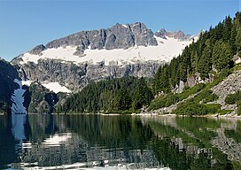
Lydia
Mountain, east aspect reflected in Lake Lovely Water, and featuring the Crescent Glacier
1473:
1468:
1463:
1458:
1433:
1382:
1340:
1275:
1250:
1230:
1225:
1175:
1160:
1140:
864:
779:
729:
714:
709:
466:
338:
247:
1315:
1305:
1285:
1150:
1095:
1090:
1085:
1030:
965:
915:
890:
854:
844:
804:
784:
435:
431:
391:
303:
292:
1115:
1387:
1345:
1300:
1280:
1010:
935:
930:
925:
849:
839:
834:
789:
769:
744:
734:
704:
670:
366:
362:
350:
330:
281:
274:
69:
1697:
1377:
1320:
1290:
1265:
1235:
1190:
1005:
980:
819:
754:
739:
694:
620:
427:
423:
419:
370:
1372:
1310:
1240:
1180:
1170:
1080:
1035:
995:
985:
895:
774:
759:
724:
684:
399:
395:
315:
394:. Several peaks in the Tantalus Range are named in association with Tantalus. The
353:, which is the highest peak in the Tantalus Range. The nearest higher neighbor is
1205:
1120:
1050:
859:
794:
749:
719:
506:
445:
358:
1402:
1397:
1355:
1325:
824:
814:
456:
602:
565:
121:
108:
1330:
1195:
1185:
1105:
1060:
1055:
1045:
143:
28:
387:
342:
237:
44:
383:
148:
639:
1514:
643:
448:(left) and Lydia Mountain reflected in Lake Lovely Water
345:. It is situated 14.5 km (9 mi) northwest of
329:
is a 2,100-metre (6,890-foot) summit located in the
1513:
1497:
1411:
1365:
883:
677:
314:
309:
291:
273:
263:
253:
243:
233:
154:
142:
137:
98:
86:
76:
63:
53:
43:
38:
21:
349:, and 5.46 km (3 mi) south-southeast of
655:
8:
434:where they are forced upward by the range (
357:, 0.5 km (0 mi) to the west, and
662:
648:
640:
18:
440:
1505:List of communities in British Columbia
530:
528:
526:
491:
398:of Lydia Mountain was made in 1914 by
207:
174:
7:
501:
499:
497:
495:
382:. The mountain was named for mythic
16:Mountain in British Columbia, Canada
1704:Two-thousanders of British Columbia
414:, Lydia Mountain is located in the
507:"Lydia Mountain, British Columbia"
380:Geographical Names Board of Canada
14:
1543:Stein Valley Nlaka'pamux Heritage
365:from the peak drains east to the
459:
206:
199:
173:
166:
27:
1648:Say Nuth Khaw Yum (Indian Arm)
1:
1719:New Westminster Land District
1548:Spruce Lake (South Chilcotin)
475:Geography of British Columbia
430:, and travel east toward the
412:Köppen climate classification
258:New Westminster Land District
93:Mountains of British Columbia
541:Geographical Names Data Base
190:Show map of British Columbia
187:Location in British Columbia
49:2,100 m (6,890 ft)
480:Geology of British Columbia
82:0.49 km (0.30 mi)
1735:
390:was a primordial ruler in
159:
26:
546:Natural Resources Canada
418:climate zone of western
335:Tantalus Provincial Park
268:Tantalus Provincial Park
591:Hydrol. Earth Syst. Sci
220:Lydia Mountain (Canada)
59:85 m (279 ft)
1593:Princess Louisa Marine
449:
122:49.77528°N 123.29333°W
626:BC Geographical Names
444:
373:via Red Tusk Creek.
286:Pacific Coast Ranges
127:49.77528; -123.29333
1714:Sea-to-Sky Corridor
402:and Allan Morkill.
264:Protected area
118: /
450:
375:Topographic relief
369:, and west to the
337:, in southwestern
223:Show map of Canada
39:Highest point
1691:
1690:
1618:Blackcomb Glacier
1538:Mount Elphinstone
1076:Frederick William
426:originate in the
416:marine west coast
324:
323:
1726:
1678:Homathko Estuary
1608:Brandywine Falls
664:
657:
650:
641:
630:
621:"Lydia Mountain"
607:
606:
586:
580:
579:
577:
576:
566:"Lydia Mountain"
562:
556:
555:
553:
552:
536:"Lydia Mountain"
532:
521:
520:
518:
517:
503:
469:
467:Mountains portal
464:
463:
462:
339:British Columbia
277:
248:British Columbia
224:
210:
209:
203:
191:
177:
176:
170:
133:
132:
130:
129:
128:
123:
119:
116:
115:
114:
111:
31:
19:
1734:
1733:
1729:
1728:
1727:
1725:
1724:
1723:
1694:
1693:
1692:
1687:
1573:Birkenhead Lake
1509:
1493:
1479:Powder Mountain
1407:
1361:
879:
673:
668:
619:
616:
611:
610:
588:
587:
583:
574:
572:
564:
563:
559:
550:
548:
534:
533:
524:
515:
513:
505:
504:
493:
488:
465:
460:
458:
455:
436:Orographic lift
432:Coast Mountains
408:
392:Greek mythology
304:Cheakamus River
284:
275:
229:
228:
227:
226:
225:
222:
221:
218:
217:
216:
215:
211:
194:
193:
192:
189:
188:
185:
184:
183:
182:
178:
126:
124:
120:
117:
112:
109:
107:
105:
104:
34:
17:
12:
11:
5:
1732:
1730:
1722:
1721:
1716:
1711:
1709:Pacific Ranges
1706:
1696:
1695:
1689:
1688:
1686:
1685:
1680:
1675:
1670:
1665:
1660:
1655:
1653:Pinecone-Burke
1650:
1645:
1640:
1635:
1630:
1628:Stawamus Chief
1625:
1620:
1615:
1610:
1605:
1600:
1595:
1590:
1585:
1580:
1575:
1570:
1565:
1560:
1555:
1553:Upper Lillooet
1550:
1545:
1540:
1535:
1530:
1525:
1519:
1517:
1511:
1510:
1508:
1507:
1501:
1499:
1495:
1494:
1492:
1491:
1486:
1481:
1476:
1471:
1466:
1461:
1456:
1451:
1446:
1441:
1439:Garibaldi Névé
1436:
1431:
1426:
1421:
1415:
1413:
1409:
1408:
1406:
1405:
1400:
1395:
1390:
1385:
1380:
1375:
1369:
1367:
1363:
1362:
1360:
1359:
1353:
1348:
1343:
1338:
1336:Vulcan's Thumb
1333:
1328:
1323:
1318:
1313:
1308:
1303:
1298:
1293:
1288:
1283:
1278:
1273:
1268:
1263:
1258:
1253:
1248:
1243:
1238:
1233:
1228:
1223:
1218:
1213:
1208:
1203:
1198:
1193:
1188:
1183:
1178:
1173:
1168:
1163:
1158:
1153:
1148:
1143:
1138:
1133:
1128:
1123:
1118:
1113:
1108:
1103:
1098:
1093:
1088:
1083:
1078:
1073:
1068:
1063:
1058:
1053:
1048:
1043:
1038:
1033:
1028:
1023:
1018:
1013:
1008:
1003:
998:
993:
988:
983:
978:
973:
968:
963:
958:
953:
948:
943:
938:
933:
928:
926:The Black Tusk
923:
918:
913:
908:
903:
898:
893:
887:
885:
881:
880:
878:
877:
872:
867:
862:
857:
852:
847:
842:
837:
832:
827:
822:
817:
812:
807:
802:
797:
792:
787:
782:
777:
772:
767:
762:
757:
752:
747:
742:
737:
732:
727:
722:
717:
712:
707:
702:
697:
692:
687:
681:
679:
675:
674:
671:Pacific Ranges
669:
667:
666:
659:
652:
644:
638:
637:
635:Lydia Mountain
631:
615:
614:External links
612:
609:
608:
581:
557:
522:
511:Peakbagger.com
490:
489:
487:
484:
483:
482:
477:
471:
470:
454:
451:
424:weather fronts
407:
404:
367:Squamish River
351:Mount Tantalus
331:Tantalus Range
327:Lydia Mountain
322:
321:
318:
312:
311:
307:
306:
295:
289:
288:
282:Tantalus Range
279:
271:
270:
265:
261:
260:
255:
251:
250:
245:
241:
240:
235:
231:
230:
219:
214:Lydia Mountain
213:
212:
205:
204:
198:
197:
196:
195:
186:
181:Lydia Mountain
180:
179:
172:
171:
165:
164:
163:
162:
161:
160:
157:
156:
152:
151:
146:
140:
139:
135:
134:
102:
96:
95:
90:
84:
83:
80:
74:
73:
70:Mount Tantalus
67:
61:
60:
57:
51:
50:
47:
41:
40:
36:
35:
32:
24:
23:
22:Lydia Mountain
15:
13:
10:
9:
6:
4:
3:
2:
1731:
1720:
1717:
1715:
1712:
1710:
1707:
1705:
1702:
1701:
1699:
1684:
1681:
1679:
1676:
1674:
1671:
1669:
1666:
1664:
1661:
1659:
1658:Shannon Falls
1656:
1654:
1651:
1649:
1646:
1644:
1641:
1639:
1638:Mount Seymour
1636:
1634:
1631:
1629:
1626:
1624:
1621:
1619:
1616:
1614:
1611:
1609:
1606:
1604:
1601:
1599:
1596:
1594:
1591:
1589:
1586:
1584:
1581:
1579:
1576:
1574:
1571:
1569:
1566:
1564:
1561:
1559:
1556:
1554:
1551:
1549:
1546:
1544:
1541:
1539:
1536:
1534:
1531:
1529:
1526:
1524:
1521:
1520:
1518:
1516:
1512:
1506:
1503:
1502:
1500:
1496:
1490:
1487:
1485:
1482:
1480:
1477:
1475:
1472:
1470:
1467:
1465:
1462:
1460:
1457:
1455:
1452:
1450:
1447:
1445:
1442:
1440:
1437:
1435:
1432:
1430:
1427:
1425:
1422:
1420:
1417:
1416:
1414:
1410:
1404:
1401:
1399:
1396:
1394:
1391:
1389:
1386:
1384:
1381:
1379:
1376:
1374:
1371:
1370:
1368:
1364:
1357:
1354:
1352:
1349:
1347:
1344:
1342:
1339:
1337:
1334:
1332:
1329:
1327:
1324:
1322:
1319:
1317:
1314:
1312:
1309:
1307:
1304:
1302:
1299:
1297:
1294:
1292:
1289:
1287:
1284:
1282:
1279:
1277:
1274:
1272:
1269:
1267:
1264:
1262:
1259:
1257:
1254:
1252:
1249:
1247:
1244:
1242:
1239:
1237:
1234:
1232:
1229:
1227:
1224:
1222:
1219:
1217:
1214:
1212:
1209:
1207:
1204:
1202:
1201:Petlushkwohap
1199:
1197:
1194:
1192:
1189:
1187:
1184:
1182:
1179:
1177:
1174:
1172:
1169:
1167:
1164:
1162:
1159:
1157:
1156:Middle Finger
1154:
1152:
1149:
1147:
1144:
1142:
1139:
1137:
1134:
1132:
1129:
1127:
1126:Little Finger
1124:
1122:
1119:
1117:
1114:
1112:
1109:
1107:
1104:
1102:
1099:
1097:
1094:
1092:
1089:
1087:
1084:
1082:
1079:
1077:
1074:
1072:
1069:
1067:
1064:
1062:
1059:
1057:
1054:
1052:
1049:
1047:
1044:
1042:
1039:
1037:
1034:
1032:
1029:
1027:
1024:
1022:
1019:
1017:
1014:
1012:
1009:
1007:
1006:Crevasse Crag
1004:
1002:
999:
997:
994:
992:
989:
987:
984:
982:
979:
977:
976:Castle Towers
974:
972:
969:
967:
964:
962:
959:
957:
954:
952:
949:
947:
944:
942:
939:
937:
934:
932:
929:
927:
924:
922:
919:
917:
914:
912:
909:
907:
904:
902:
899:
897:
894:
892:
889:
888:
886:
882:
876:
873:
871:
868:
866:
863:
861:
858:
856:
853:
851:
848:
846:
843:
841:
838:
836:
833:
831:
828:
826:
823:
821:
818:
816:
813:
811:
808:
806:
803:
801:
798:
796:
793:
791:
788:
786:
783:
781:
778:
776:
773:
771:
768:
766:
763:
761:
758:
756:
753:
751:
748:
746:
743:
741:
738:
736:
733:
731:
728:
726:
723:
721:
718:
716:
713:
711:
708:
706:
703:
701:
698:
696:
693:
691:
688:
686:
683:
682:
680:
676:
672:
665:
660:
658:
653:
651:
646:
645:
642:
636:
632:
628:
627:
622:
618:
617:
613:
604:
600:
596:
592:
585:
582:
571:
567:
561:
558:
547:
543:
542:
537:
531:
529:
527:
523:
512:
508:
502:
500:
498:
496:
492:
485:
481:
478:
476:
473:
472:
468:
457:
452:
447:
443:
439:
437:
433:
429:
428:Pacific Ocean
425:
421:
420:North America
417:
413:
410:Based on the
405:
403:
401:
400:Basil Darling
397:
393:
389:
385:
381:
376:
372:
371:Clowhom River
368:
364:
360:
356:
352:
348:
344:
340:
336:
332:
328:
319:
317:
313:
308:
305:
302:
299:
296:
294:
290:
287:
283:
280:
278:
272:
269:
266:
262:
259:
256:
252:
249:
246:
242:
239:
236:
232:
202:
169:
158:
153:
150:
147:
145:
141:
136:
131:
103:
101:
97:
94:
91:
89:
85:
81:
79:
75:
72:(2603 m)
71:
68:
66:
62:
58:
56:
52:
48:
46:
42:
37:
30:
25:
20:
1588:Bishop River
1578:Joffre Lakes
1568:Mehatl Creek
1484:Silverthrone
1424:Compton Névé
1271:Silverthrone
946:Breakenridge
624:
594:
590:
584:
573:. Retrieved
569:
560:
549:. Retrieved
539:
514:. Retrieved
510:
409:
396:first ascent
355:The Red Tusk
354:
326:
325:
316:First ascent
276:Parent range
1663:Rolley Lake
1623:Tetrahedron
1603:Nairn Falls
1558:Golden Ears
1528:Duffey Lake
1523:Clendinning
1498:Communities
1383:McGillivray
1226:Pyroclastic
1131:Little Ring
1111:Judge Howay
991:Cinder Cone
875:Whitemantle
870:Wharncliffe
830:North Shore
765:Fitzsimmons
700:Cadwallader
570:Bivouac.com
446:Mount Niobe
386:, of which
359:Mount Niobe
125: /
113:123°17′36″W
100:Coordinates
65:Parent peak
1698:Categories
1683:Davis Lake
1613:Alice Lake
1454:Klinaklini
1351:Wellington
1341:Waddington
1251:Robie Reid
1231:Queen Bess
1071:Forefinger
1066:Fitzgerald
1031:Devastator
941:Brandywine
916:Birkenhead
865:Waddington
715:Cantilever
710:Camelsfoot
575:2023-02-02
551:2021-10-23
516:2021-10-23
486:References
110:49°46′31″N
55:Prominence
1673:Big Creek
1668:Sasquatch
1598:Callaghan
1533:Garibaldi
1489:Spearhead
1444:Ha-Iltzuk
1388:Pemberton
1316:Tiedemann
1291:Spearhead
1286:Somolenko
1186:Opal Cone
1091:Good Hope
1086:Garibaldi
1001:Coquitlam
971:Capricorn
966:Callaghan
936:Blanshard
931:Blackcomb
884:Mountains
855:Tottenham
845:Sir Harry
785:Gastineau
780:Garibaldi
730:Chilcotin
690:Britannia
633:Weather:
603:1027-5606
155:Geography
144:Etymology
78:Isolation
45:Elevation
1583:Ts'il?os
1563:Tantalus
1474:Pashleth
1469:Parallel
1449:Homathko
1434:Franklin
1412:Glaciers
1393:Railroad
1378:Griswold
1321:Tricouni
1301:Tantalus
1261:Serratus
1241:Red Tusk
1166:Monmouth
1011:Crickmer
981:Cauldron
911:Asperity
850:Tantalus
840:Pembroke
835:Pantheon
805:Lillooet
790:Georgina
770:Franklyn
735:Colville
705:Calliope
453:See also
388:Tantalus
347:Squamish
310:Climbing
293:Topo map
254:District
244:Province
1643:Cypress
1464:Monarch
1459:Mamquam
1429:Diamond
1373:Cayoosh
1356:ʔEniyud
1276:Skihist
1266:Seymour
1236:Raleigh
1191:Overill
1181:One Eye
1176:Nicomen
1161:Monarch
1141:Mamquam
1036:Dewdney
1026:Cypress
820:Nicholl
755:Edwards
745:Douglas
740:Conical
695:Bunster
422:. Most
406:Climate
234:Country
88:Listing
1633:Murrin
1366:Passes
1358:(Niut)
1311:Tatlow
1306:Taseko
1211:Powder
1206:Plinth
1171:Munday
1151:Merlon
1146:Meager
1101:Helena
1096:Grouse
1081:Fromme
1021:Currie
996:Clarke
986:Cayley
921:Bishop
906:Arthur
896:Alfred
891:Akasik
810:Meager
775:Fraser
760:Fannin
725:Cayley
685:Bendor
678:Ranges
601:
363:runoff
343:Canada
238:Canada
138:Naming
1515:Parks
1419:Chaos
1403:Wedge
1398:Tyoax
1346:Wedge
1326:Tuber
1296:Table
1281:Stein
1256:Round
1221:Pylon
1216:Price
1121:Kinch
1116:ḵ’els
1051:Elsay
1041:Eagle
1016:Crown
961:Burke
901:Alice
860:Unwin
800:Lewis
795:Koeye
750:Earle
720:Caren
384:Lydia
333:, in
301:92G14
149:Lydia
1246:Ring
1196:Pali
1136:Luna
1056:Fang
1046:Edge
956:Brew
951:Brew
825:Niut
815:Namu
599:ISSN
320:1914
1331:Vic
1106:Job
1061:Fee
298:NTS
1700::
623:.
597:.
595:11
593:.
568:.
544:.
538:.
525:^
509:.
494:^
341:,
663:e
656:t
649:v
629:.
605:.
578:.
554:.
519:.
Text is available under the Creative Commons Attribution-ShareAlike License. Additional terms may apply.