61:
38:
1025:
94:
1011:
101:
68:
377:
Along an 8-kilometre (5.0 mi) stretch of sandy beaches on the northern shore is Sandy Beach Resort. The resort has a lodge with six guest rooms, a lounge, licensed dining, conference facilities, camping with RV hookups, and access to the lake for swimming, boating, and fishing.
357:) is at the start of Rivière la Plonge, about 8 kilometres (5.0 mi) north-east of Beauval. The original dam was built in the 1930s and then reconstructed in 1985. Further upgrades were undertaken in 2010, which included upgraded hydraulic control and the addition of a
395:
Lac la Plonge
Campground is a recreational park that has 19 campsites and access to the lake for fishing, swimming, and boating. The park stretches from Rivière la Plonge and the dam north to Angler's Trail Resort.
386:
At the north-west corner of the lake is Angler's Trail Resort. Angler's Trail has access to the lake, cabin rentals, a campground, convenience store, restaurant with licensed dining, and a tackle shop.
1056:
60:
986:
945:
369:
Recreational facilities are at the northern part of the lake and include two resorts and a recreational area / campground. Access is from
Highway 165.
897:
960:
458:
910:
276:
478:
315:
930:
232:
1066:
530:
143:
93:
1051:
940:
1061:
970:
453:
950:
310:
The Rivière la Plonge, Lac la Plonge's outflow, flows west from the north-west section of the lake into Beaver River at
300:
251:
22:
329:
890:
935:
788:
288:
991:
955:
925:
304:
965:
906:
761:
292:
37:
996:
883:
709:
311:
284:
175:
683:
657:
875:
814:
556:
504:
259:
1015:
840:
437:
296:
425:
187:
1045:
1029:
630:
417:
735:
314:. The lake's outflow is the site of the Lac La Plonge Dam, which is operated by the
433:
429:
413:
280:
272:
129:
46:
604:
358:
421:
344:
331:
158:
145:
405:
865:
582:
176:
441:
409:
193:
611:. Gabriel Dumont Institute of Native Studies and Applied Research
42:
879:
870:
361:. The dam is 1.7 m (5 ft 7 in) high.
21:
This article is about the lake. For the hamlet, see
979:
918:
247:
231:
227:
219:
211:
203:
199:
186:
174:
135:
125:
30:
299:. On the lake's northern shore, the community of
136:
891:
404:Fish commonly found in Lac la Plonge include
303:, a resort, and campgrounds are accessed via
8:
609:Virtual Museum of Metis History and Culture
1057:Division No. 18, Unorganized, Saskatchewan
898:
884:
876:
27:
815:"30 Free Places to Camp in Saskatchewan"
789:"Where to Camp for Free in Saskatchewan"
470:
459:List of dams and reservoirs in Canada
100:
67:
7:
664:. Missinipi Broadcasting Corporation
658:"Lac La Plonge Dam Upgrade Underway"
561:Canadian Geographical Names Database
509:Canadian Geographical Names Database
742:. Canadian Camping & RV Council
316:Saskatchewan Water Security Agency
14:
656:Orthner, Bryan (6 October 2006).
1023:
1010:
1009:
605:"Dam on a river (Lac la Plonge)"
99:
92:
66:
59:
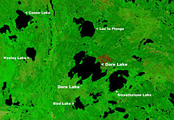
45:image of Lac la Plonge north of
36:
479:"Lac la Plonge topographic map"
218:
210:
202:
1:
787:Lemna, Sam (3 January 2023).
454:List of lakes of Saskatchewan
124:
768:. Government of Saskatchewan
716:. Government of Saskatchewan
690:. Government of Saskatchewan
381:
215:109.8 km (68.2 mi)
16:Lake in Saskatchewan, Canada
531:"Lac La Plonge Fishing Map"
23:Lac La Plonge, Saskatchewan
1083:
762:"Lac la Plonge Campground"
260:not a well-defined measure
223:466 m (1,529 ft)
20:
1005:
946:Newfoundland and Labrador
795:. RV Direct Insurance Ltd
257:
53:
35:
391:Lac la Plonge Campground
83:Show map of Saskatchewan
80:Location in Saskatchewan
907:List of lakes of Canada
736:"Angler's Trail Resort"
710:"Angler's Trail Resort"
637:. Water Security Agency
485:. World Topographic Map
291:. It is located in the
207:65 m (213 ft)
1067:Dams completed in 1985
563:. Government of Canada
511:. Government of Canada
113:Lac la Plonge (Canada)
1052:Lakes of Saskatchewan
987:Northwest Territories
911:province or territory
866:Angler's Trail Resort
631:"Dams and Reservoirs"
382:Angler's Trail Resort
1062:Dams in Saskatchewan
961:Prince Edward Island
766:Tourism Saskatchewan
714:Tourism Saskatchewan
688:Tourism Saskatchewan
684:"Sandy Beach Resort"
345:55.1611°N 107.5092°W
283:in the basin of the
793:RV Direct Insurance
557:"Rivière la Plonge"
535:GPS Nautical Charts
483:topographic-map.com
341: /
326:Lac la Plonge Dam (
289:Lac Île-à-la-Crosse
155: /
871:Sandy Beach Resort
821:. Explore Magazine
373:Sandy Beach Resort
350:55.1611; -107.5092
159:55.133°N 107.333°W
116:Show map of Canada
1039:
1038:
1030:Canada portal
322:Lac la Plonge Dam
277:Canadian province
266:
265:
220:Surface elevation
182:Rivière la Plonge
1074:
1028:
1027:
1026:
1013:
1012:
931:British Columbia
900:
893:
886:
877:
853:
852:
850:
848:
843:. Angler's Atlas
837:
831:
830:
828:
826:
811:
805:
804:
802:
800:
784:
778:
777:
775:
773:
758:
752:
751:
749:
747:
732:
726:
725:
723:
721:
706:
700:
699:
697:
695:
680:
674:
673:
671:
669:
653:
647:
646:
644:
642:
627:
621:
620:
618:
616:
601:
595:
594:
592:
590:
579:
573:
572:
570:
568:
553:
547:
546:
544:
542:
527:
521:
520:
518:
516:
501:
495:
494:
492:
490:
475:
356:
355:
353:
352:
351:
346:
342:
339:
338:
337:
334:
258:Shore length is
178:
177:Primary outflows
170:
169:
167:
166:
165:
164:55.133; -107.333
160:
156:
153:
152:
151:
148:
138:
117:
103:
102:
96:
84:
70:
69:
63:
40:
28:
1082:
1081:
1077:
1076:
1075:
1073:
1072:
1071:
1042:
1041:
1040:
1035:
1024:
1022:
1001:
975:
914:
904:
862:
857:
856:
846:
844:
841:"Lac la Plonge"
839:
838:
834:
824:
822:
813:
812:
808:
798:
796:
786:
785:
781:
771:
769:
760:
759:
755:
745:
743:
734:
733:
729:
719:
717:
708:
707:
703:
693:
691:
682:
681:
677:
667:
665:
655:
654:
650:
640:
638:
629:
628:
624:
614:
612:
603:
602:
598:
588:
586:
583:"Lac la Plonge"
581:
580:
576:
566:
564:
555:
554:
550:
540:
538:
529:
528:
524:
514:
512:
505:"Lac la Plonge"
503:
502:
498:
488:
486:
477:
476:
472:
467:
450:
438:longnose sucker
402:
393:
384:
375:
367:
349:
347:
343:
340:
335:
332:
330:
328:
327:
324:
297:Canadian Shield
243:
190: countries
163:
161:
157:
154:
149:
146:
144:
142:
141:
121:
120:
119:
118:
115:
114:
111:
110:
109:
108:
104:
87:
86:
85:
82:
81:
78:
77:
76:
75:
71:
49:
26:
17:
12:
11:
5:
1080:
1078:
1070:
1069:
1064:
1059:
1054:
1044:
1043:
1037:
1036:
1034:
1033:
1019:
1006:
1003:
1002:
1000:
999:
994:
989:
983:
981:
977:
976:
974:
973:
968:
963:
958:
953:
948:
943:
938:
933:
928:
922:
920:
916:
915:
905:
903:
902:
895:
888:
880:
874:
873:
868:
861:
860:External links
858:
855:
854:
832:
806:
779:
753:
727:
701:
675:
648:
622:
596:
574:
548:
522:
496:
469:
468:
466:
463:
462:
461:
456:
449:
446:
426:lake whitefish
401:
398:
392:
389:
383:
380:
374:
371:
366:
363:
323:
320:
264:
263:
255:
254:
249:
245:
244:
242:
241:
237:
235:
229:
228:
225:
224:
221:
217:
216:
213:
209:
208:
205:
201:
200:
197:
196:
191:
184:
183:
180:
172:
171:
139:
133:
132:
127:
123:
122:
112:
106:
105:
98:
97:
91:
90:
89:
88:
79:
73:
72:
65:
64:
58:
57:
56:
55:
54:
51:
50:
41:
33:
32:
15:
13:
10:
9:
6:
4:
3:
2:
1079:
1068:
1065:
1063:
1060:
1058:
1055:
1053:
1050:
1049:
1047:
1032:
1031:
1020:
1018:
1017:
1008:
1007:
1004:
998:
995:
993:
990:
988:
985:
984:
982:
978:
972:
969:
967:
964:
962:
959:
957:
954:
952:
949:
947:
944:
942:
941:New Brunswick
939:
937:
934:
932:
929:
927:
924:
923:
921:
917:
912:
908:
901:
896:
894:
889:
887:
882:
881:
878:
872:
869:
867:
864:
863:
859:
842:
836:
833:
820:
816:
810:
807:
794:
790:
783:
780:
767:
763:
757:
754:
741:
737:
731:
728:
715:
711:
705:
702:
689:
685:
679:
676:
663:
659:
652:
649:
636:
632:
626:
623:
610:
606:
600:
597:
584:
578:
575:
562:
558:
552:
549:
536:
532:
526:
523:
510:
506:
500:
497:
484:
480:
474:
471:
464:
460:
457:
455:
452:
451:
447:
445:
443:
439:
435:
431:
427:
423:
419:
418:northern pike
415:
411:
407:
399:
397:
390:
388:
379:
372:
370:
364:
362:
360:
354:
321:
319:
317:
313:
308:
306:
302:
301:Lac La Plonge
298:
294:
293:boreal forest
290:
286:
282:
278:
274:
270:
269:Lac la Plonge
261:
256:
253:
252:Lac La Plonge
250:
246:
239:
238:
236:
234:
230:
226:
222:
214:
206:
198:
195:
192:
189:
185:
181:
179:
173:
168:
140:
134:
131:
128:
107:Lac la Plonge
95:
74:Lac la Plonge
62:
52:
48:
44:
39:
34:
31:Lac la Plonge
29:
24:
19:
1021:
1014:
971:Saskatchewan
845:. Retrieved
835:
823:. Retrieved
818:
809:
797:. Retrieved
792:
782:
770:. Retrieved
765:
756:
744:. Retrieved
739:
730:
718:. Retrieved
713:
704:
692:. Retrieved
687:
678:
666:. Retrieved
661:
651:
639:. Retrieved
634:
625:
613:. Retrieved
608:
599:
587:. Retrieved
585:. Sask Lakes
577:
565:. Retrieved
560:
551:
539:. Retrieved
534:
525:
513:. Retrieved
508:
499:
487:. Retrieved
482:
473:
434:white sucker
414:yellow perch
403:
400:Fish species
394:
385:
376:
368:
325:
309:
285:Beaver River
281:Saskatchewan
273:glacial lake
268:
267:
240:Weber Island
212:Shore length
130:Saskatchewan
18:
980:Territories
951:Nova Scotia
359:fish ladder
348: /
336:107°30′33″W
305:Highway 165
248:Settlements
162: /
137:Coordinates
1046:Categories
537:. Bist LLC
465:References
422:lake trout
365:Recreation
333:55°09′40″N
204:Max. depth
919:Provinces
662:MBC Radio
295:near the
47:Doré Lake
1016:Category
936:Manitoba
847:13 March
799:15 March
772:15 March
746:15 March
720:15 March
694:15 March
668:13 March
641:12 March
615:13 March
589:13 March
567:13 March
541:13 March
515:12 March
489:13 March
448:See also
150:107°20′W
126:Location
992:Nunavut
956:Ontario
926:Alberta
825:3 April
819:Explore
406:walleye
312:Beauval
287:, near
275:in the
233:Islands
147:55°08′N
966:Quebec
442:burbot
440:, and
410:sauger
194:Canada
997:Yukon
740:CCRVC
635:wsask
430:cisco
271:is a
188:Basin
909:(by
849:2024
827:2024
801:2024
774:2024
748:2024
722:2024
696:2024
670:2024
643:2024
617:2024
591:2024
569:2024
543:2024
517:2024
491:2024
43:NASA
279:of
1048::
817:.
791:.
764:.
738:.
712:.
686:.
660:.
633:.
607:.
559:.
533:.
507:.
481:.
444:.
436:,
432:,
428:,
424:,
420:,
416:,
412:,
408:,
318:.
307:.
913:)
899:e
892:t
885:v
851:.
829:.
803:.
776:.
750:.
724:.
698:.
672:.
645:.
619:.
593:.
571:.
545:.
519:.
493:.
262:.
25:.
Text is available under the Creative Commons Attribution-ShareAlike License. Additional terms may apply.