553:
606:
36:
277:
52:
146:
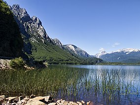
153:, which borders the eastern shore of Las Torres Lake. The reserve is named for that lake, but it is not contained within the reserve's boundaries. It is located 125 km north of
590:
265:
337:
512:
701:
696:
691:
676:
647:
583:
427:
706:
477:
417:
258:
69:
686:
681:
243:
576:
472:
502:
671:
292:
251:
482:
205:
457:
387:
312:
307:
377:
497:
397:
332:
302:
640:
407:
507:
422:
402:
382:
25:
492:
168:
This protected area was established in 1969 as a national park. This designation was changed in 1982 to a national reserve.
392:
362:
342:
317:
432:
372:
352:
231:
532:
527:
517:
442:
437:
412:
347:
633:
357:
322:
666:
522:
467:
297:
452:
327:
281:
552:
462:
487:
447:
150:
613:
35:
617:
560:
138:
660:
235:
605:
162:
228:
84:
71:
158:
154:
185:
276:
209:
142:
57:
188:
from the World
Database on Protected Areas. Retrieved 1 May 2023.
559:
This article related to a protected area in South
America is a
247:
621:
564:
124:
116:
108:
100:
63:
45:
18:
147:Aysén del General Carlos Ibáñez del Campo Region
641:
584:
259:
149:. The reserve is marginally traversed by the
8:
648:
634:
591:
577:
266:
252:
244:
186:Protected Area Profile for Lago Las Torres
15:
165:approximately marks its northern border.
200:
198:
196:
194:
177:
128:Corporación Nacional Forestal (CONAF)
7:
602:
600:
549:
547:
44:
28:IV (habitat/species management area)
702:South American protected area stubs
697:Protected areas established in 1982
692:Protected areas established in 1969
206:"Plan de Manejo RN Lago Las Torres"
14:
229:World Database on Protected Areas
604:
551:
275:
135:Lago Las Torres National Reserve
50:
34:
19:Lago Las Torres National Reserve
677:Protected areas of Aysén Region
115:
1:
707:Aysén Region geography stubs
687:1982 establishments in Chile
682:1969 establishments in Chile
620:. You can help Knowledge by
563:. You can help Knowledge by
513:Roblería del Cobre de Loncha
723:
672:National reserves of Chile
599:
546:
282:National Reserves of Chile
288:
33:
23:
428:Los Huemules de Niblinto
418:Los Bellotos del Melado
616:location article is a
478:Pingüino de Humboldt
473:Pampa del Tamarugal
157:and is bordered by
125:Governing body
81: /
184:UNEP-WCMC (2023).
629:
628:
572:
571:
541:
540:
523:Valdivian Coastal
483:Radal Siete Tazas
338:Francisco Coloane
151:Carretera Austral
132:
131:
85:44.800°S 72.200°W
714:
667:IUCN Category IV
650:
643:
636:
608:
601:
593:
586:
579:
555:
548:
503:Río Los Cipreses
458:Mocho-Choshuenco
388:Laguna Parrillar
313:Carlos Anwandter
308:Altos de Pemehue
280:
279:
268:
261:
254:
245:
238:
226:
220:
219:
217:
216:
202:
189:
182:
112:National reserve
96:
95:
93:
92:
91:
90:-44.800; -72.200
86:
82:
79:
78:
77:
74:
56:
54:
53:
38:
16:
722:
721:
717:
716:
715:
713:
712:
711:
657:
656:
655:
654:
598:
597:
544:
542:
537:
398:Las Chinchillas
368:Lago Las Torres
333:Federico Albert
303:Altos de Lircay
284:
274:
272:
242:
241:
227:
223:
214:
212:
204:
203:
192:
183:
179:
174:
89:
87:
83:
80:
75:
72:
70:
68:
67:
51:
49:
41:
40:Las Torres Lake
29:
12:
11:
5:
720:
718:
710:
709:
704:
699:
694:
689:
684:
679:
674:
669:
659:
658:
653:
652:
645:
638:
630:
627:
626:
609:
596:
595:
588:
581:
573:
570:
569:
556:
539:
538:
536:
535:
530:
525:
520:
515:
510:
505:
500:
495:
490:
485:
480:
475:
470:
465:
460:
455:
450:
445:
440:
435:
430:
425:
420:
415:
410:
405:
400:
395:
390:
385:
380:
375:
370:
365:
360:
355:
350:
345:
340:
335:
330:
325:
320:
315:
310:
305:
300:
295:
289:
286:
285:
273:
271:
270:
263:
256:
248:
240:
239:
234:2012-12-05 at
221:
208:(in Spanish).
190:
176:
175:
173:
170:
139:nature reserve
137:is a national
130:
129:
126:
122:
121:
118:
114:
113:
110:
106:
105:
102:
98:
97:
65:
61:
60:
47:
43:
42:
39:
31:
30:
24:
21:
20:
13:
10:
9:
6:
4:
3:
2:
719:
708:
705:
703:
700:
698:
695:
693:
690:
688:
685:
683:
680:
678:
675:
673:
670:
668:
665:
664:
662:
651:
646:
644:
639:
637:
632:
631:
625:
623:
619:
615:
610:
607:
603:
594:
589:
587:
582:
580:
575:
574:
568:
566:
562:
557:
554:
550:
545:
534:
531:
529:
526:
524:
521:
519:
516:
514:
511:
509:
506:
504:
501:
499:
496:
494:
491:
489:
486:
484:
481:
479:
476:
474:
471:
469:
466:
464:
461:
459:
456:
454:
451:
449:
448:Malalcahuello
446:
444:
441:
439:
436:
434:
431:
429:
426:
424:
423:Los Flamencos
421:
419:
416:
414:
411:
409:
406:
404:
403:Las Guaitecas
401:
399:
396:
394:
391:
389:
386:
384:
383:Lago Rosselot
381:
379:
378:Lago Peñuelas
376:
374:
371:
369:
366:
364:
361:
359:
356:
354:
351:
349:
346:
344:
341:
339:
336:
334:
331:
329:
326:
324:
321:
319:
316:
314:
311:
309:
306:
304:
301:
299:
296:
294:
291:
290:
287:
283:
278:
269:
264:
262:
257:
255:
250:
249:
246:
237:
236:archive.today
233:
230:
225:
222:
211:
207:
201:
199:
197:
195:
191:
187:
181:
178:
171:
169:
166:
164:
161:to the east.
160:
156:
152:
148:
144:
140:
136:
127:
123:
119:
111:
107:
103:
99:
94:
66:
62:
59:
48:
37:
32:
27:
26:IUCN category
22:
17:
622:expanding it
614:Aysén Region
611:
565:expanding it
558:
543:
498:Río Clarillo
393:Laguna Torca
367:
363:Lago Carlota
318:China Muerta
293:Alto Bío Bío
224:
213:. Retrieved
180:
167:
163:Cisnes River
141:of southern
134:
133:
508:Río Simpson
433:Los Queules
408:Las Vicuñas
373:Lago Palena
353:Katalalixar
109:Designation
88: /
64:Coordinates
661:Categories
533:Yerba Loca
528:Villarrica
518:Trapananda
493:Río Blanco
443:Magallanes
438:Los Ruiles
413:Llanquihue
348:Isla Mocha
215:2014-02-09
172:References
117:Designated
104:165.16 km
358:La Chimba
343:Futaleufú
323:Coyhaique
159:Argentina
155:Coyhaique
298:Alto Loa
232:Archived
46:Location
453:Malleco
328:El Yali
76:72°12′W
73:44°48′S
463:Nalcas
55:
612:This
488:Ralco
468:Ñuble
210:CONAF
143:Chile
58:Chile
618:stub
561:stub
120:1982
101:Area
145:'s
663::
193:^
649:e
642:t
635:v
624:.
592:e
585:t
578:v
567:.
267:e
260:t
253:v
218:.
Text is available under the Creative Commons Attribution-ShareAlike License. Additional terms may apply.