31:
363:
rely mostly on sheep and yak herding for subsistence in the Ladakh Range. Tibet's Chang Tang plain, most remote section of
Himalayas, is extreme high country; here the valleys are about 14,000 feet above sea level.
584:
Warikoo, K. (2009), "India's gateway to
Central Asia: trans-Himalayan trade and cultural movements through Kashmir and Ladakh, 1846–1947", in K. Warikoo (ed.),
371:
Ladakhis with their traditions and intimate knowledge of local environment have survived and actually prospered, in spite of centuries of invasions from the
623:
306:). The winter route passed through Digar La to reach the Shyok river valley and, again, reach the Karakoram Pass. The trade route to Tibet went via
682:
677:
595:
575:
555:
535:
515:
687:
128:
672:
294:
and rest of the Indian subcontinent on the other. The summer route from Leh to
Yarkand passed through Khardung La to pass into the
255:
The Ladakh Range has an average height of about 6,000 metres and has no major peaks. Some of its peaks are less than 4,800 metres.
325:
wool (once worth its weight in gold); yak and pony caravans brought in pashmina from Tibet, turquoise, coral and silver from
667:
662:
349:
121:
367:
Ladakh is a desert region. Culturally/geographically close to Tibet, it has few resources with an extreme climate. The
611:
282:, a little way from the Indus River along the Khardung La valley, is a historic trading town with trade routes to
356:
visiting Leh in 1820, were stunned seeing a town of such wealth located in midst of obviously arid desert land.
234:
303:
591:
571:
551:
531:
511:
565:
525:
503:
585:
391:
410:
408:
406:
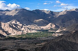
209:, the capital city of Ladakh, is on the foot of Ladakh Range in the Indus river valley.
353:
326:
299:
283:
160:
656:
238:
237:
of Ladakh in the southeast. The southern extension of the Ladakh Range is called the
177:
104:
587:
Himalayan
Frontiers of India: Historical, Geo-Political and Strategic Perspectives
508:
Himalayan
Frontiers of India: Historical, Geo-Political and Strategic Perspectives
545:
426:
311:
295:
263:
249:
245:
226:
222:
202:
198:
638:
625:
143:
130:
486:
474:
230:
218:
194:
167:
94:
85:
30:
384:
368:
322:
315:
291:
267:
221:
Range, which runs for 230 miles (370 km) from the confluence of the
547:
An "agreed" frontier: Ladakh and India's northernmost borders, 1846-1947
414:
372:
360:
342:
330:
259:
450:
438:
380:
376:
307:
190:
90:
387:(from east). The mixed ethnic origins are reflected in their faces.
310:
in the Indus river valley at the foot of the
Kailash Range. By the
334:
287:
78:
338:
314:
signed in 1684, Ladakh had the exclusive right to trade in the
279:
206:
114:
36:
217:
The Ladakh Range is regarded as a southern extension of the
462:
390:
The extension of the Ladakh Range into China is known as
504:"Strategic dimensions of the trans-Himalayan frontiers"
205:
river valleys, stretching to 230 miles (370 km).
244:
The Ladakh Range forms the northeastern bank of the
429:, Encyclopedia Britannica, retrieved 22 April 2018.
173:
159:
120:
110:
100:
84:
74:
56:
48:
43:
23:
318:wool from Tibet, which led to its prosperity.
193:in India with its northern tip extending into
487:Warikoo, India's gateway to Central Asia 2009
475:Warikoo, India's gateway to Central Asia 2009
415:Negi, Discovering the Himalaya, Volume 1 1998
8:
321:Leh was for centuries trade centre for fine
270:(5,599 metres) and Tsaka La (4,724 metres).
20:
617:, via Bame Duniya blogspot, 19 March 2013
262:(5,090 metres), Digar La (5,400 metres),
402:
66:Interactive map outlining Ladakh range
7:
16:Mountain range in India and Pakistan
567:Discovering the Himalaya, Volume 1
14:
197:in Pakistan. It lies between the
463:Kaul, Rediscovery of Ladakh 1998
451:Mehra, An "agreed" frontier 1992
439:Mehra, An "agreed" frontier 1992
29:
189:is a mountain range in central
614:Ladakh: Changing yet Unchanged
298:and thence to Yarkand via the
1:
683:Geography of Gilgit-Baltistan
678:Landforms of Gilgit-Baltistan
510:, Routledge, pp. 56–66,
258:The main mountain passes are
590:, Routledge, pp. 1–13,
248:and the western bank of the
688:Mountain ranges of Pakistan
550:, Oxford University Press,
35:View of Ladakh Range above
706:
544:Mehra, Parshotam (1992),
375:(from central Asia), the
61:
52:370 km (230 mi)
28:
673:Mountain ranges of India
506:, in K. Warikoo (ed.),
348:Two English explorers,
333:, spices, fabrics from
302:and Suget Pass (in the
241:, especially in Tibet.
383:(from south) and even
610:Romesh Bhattacharji,
527:Rediscovery of Ladakh
502:Karim, Afsir (2009),
312:Treaty of Tingmosgang
304:Trans-Karakoram Tract
290:on the one hand, and
570:, Indus Publishing,
564:Negi, S. S. (1998),
530:, Indus Publishing,
524:Kaul, H. N. (1998),
668:Geography of Ladakh
663:Landforms of Ladakh
635: /
140: /
597:978-1-134-03294-5
577:978-81-7387-079-8
557:978-0-19-562758-9
537:978-81-7387-086-6
517:978-1-134-03294-5
350:William Moorcroft
183:
182:
122:Range coordinates
695:
650:
649:
647:
646:
645:
640:
636:
633:
632:
631:
628:
600:
580:
560:
540:
520:
490:
484:
478:
472:
466:
460:
454:
448:
442:
436:
430:
424:
418:
412:
266:(5,602 metres),
163:
155:
154:
152:
151:
150:
145:
141:
138:
137:
136:
133:
33:
21:
705:
704:
698:
697:
696:
694:
693:
692:
653:
652:
643:
641:
639:34.66°N 76.88°E
637:
634:
629:
626:
624:
622:
621:
607:
598:
583:
578:
563:
558:
543:
538:
523:
518:
501:
498:
493:
485:
481:
473:
469:
461:
457:
449:
445:
437:
433:
425:
421:
413:
404:
400:
276:
215:
161:
148:
146:
144:34.66°N 76.88°E
142:
139:
134:
131:
129:
127:
126:
70:
69:
68:
67:
39:
17:
12:
11:
5:
703:
702:
699:
691:
690:
685:
680:
675:
670:
665:
655:
654:
619:
618:
606:
605:External links
603:
602:
601:
596:
581:
576:
561:
556:
541:
536:
521:
516:
497:
494:
492:
491:
479:
467:
455:
443:
431:
419:
401:
399:
396:
354:George Trebeck
300:Karakoram Pass
275:
272:
235:Tibetan border
214:
211:
181:
180:
175:
171:
170:
165:
157:
156:
124:
118:
117:
112:
108:
107:
102:
98:
97:
88:
82:
81:
76:
72:
71:
65:
64:
63:
62:
59:
58:
54:
53:
50:
46:
45:
41:
40:
34:
26:
25:
15:
13:
10:
9:
6:
4:
3:
2:
701:
700:
689:
686:
684:
681:
679:
676:
674:
671:
669:
666:
664:
661:
660:
658:
651:
648:
616:
615:
609:
608:
604:
599:
593:
589:
588:
582:
579:
573:
569:
568:
562:
559:
553:
549:
548:
542:
539:
533:
529:
528:
522:
519:
513:
509:
505:
500:
499:
495:
488:
483:
480:
476:
471:
468:
465:, p. 17.
464:
459:
456:
453:, p. 15.
452:
447:
444:
441:, end papers.
440:
435:
432:
428:
423:
420:
417:, p. 14.
416:
411:
409:
407:
403:
397:
395:
393:
392:Kailash Range
388:
386:
382:
379:(from west),
378:
374:
370:
365:
362:
357:
355:
351:
346:
344:
340:
336:
332:
328:
324:
319:
317:
313:
309:
305:
301:
297:
293:
289:
285:
281:
273:
271:
269:
265:
261:
256:
253:
251:
247:
242:
240:
239:Kailash Range
236:
232:
228:
224:
220:
212:
210:
208:
204:
200:
196:
192:
188:
179:
178:Kailash Range
176:
172:
169:
166:
164:
158:
153:
125:
123:
119:
116:
113:
109:
106:
103:
99:
96:
92:
89:
87:
83:
80:
77:
73:
60:
55:
51:
47:
42:
38:
32:
27:
22:
19:
644:34.66; 76.88
620:
613:
586:
566:
546:
526:
507:
496:Bibliography
489:, p. 4.
482:
477:, p. 1.
470:
458:
446:
434:
427:Ladakh Range
422:
389:
366:
359:The nomadic
358:
347:
320:
296:Nubra valley
278:The city of
277:
257:
254:
243:
216:
187:Ladakh Range
186:
184:
162:Parent range
149:34.66; 76.88
24:Ladakh Range
18:
642: /
264:Khardung La
250:Shyok River
246:Indus River
147: /
657:Categories
398:References
381:the Dogras
274:Habitation
229:rivers in
174:Borders on
44:Dimensions
231:Baltistan
219:Karakoram
213:Geography
195:Baltistan
168:Karakoram
95:Baltistan
86:Territory
57:Geography
612:Maps of
385:Tibetans
369:Buddhist
323:pashmina
316:pashmina
292:Srinagar
268:Chang La
101:District
630:76°53′E
627:34°40′N
373:Mongols
361:Changpa
343:Kashmir
331:Kashgar
327:Yarkand
284:Yarkand
260:Chorbat
233:to the
135:76°53′E
132:34°40′N
75:Country
594:
574:
554:
534:
514:
377:Baltis
308:Gartok
191:Ladakh
91:Ladakh
49:Length
341:from
335:India
288:Tibet
227:Shyok
223:Indus
203:Shyok
199:Indus
79:India
592:ISBN
572:ISBN
552:ISBN
532:ISBN
512:ISBN
352:and
339:silk
337:and
329:and
286:and
225:and
201:and
185:The
111:City
280:Leh
207:Leh
115:Leh
105:Leh
37:Leh
659::
405:^
394:.
345:.
252:.
93:,
Text is available under the Creative Commons Attribution-ShareAlike License. Additional terms may apply.