74:
46:
304:
29:
512:
81:
53:
480:
content, and hot weather. Studies of water quality found phosphorus to be present in high levels which contributed to the algal bloom. Beginning in 1995, the water quality was monitored and an improvement plan was implemented to lower the phosphorus by 37 percent. By 2003 the lake had 57 percent less
452:
manages the reservoir and estimated the draining could take place over the course of a year at a cost of $ 100,000 to $ 300,000. The U. S. Bureau of
Reclamation withdrew its application for an
723:
436:
that live up to 15 years and compete for food stocks. Issues involved in mitigating damage during the lowering of the lake level include maintaining an adequate supply for
743:
733:
660:
45:
728:
376:, completed 76 years ago in 1948. The term "Lake Cascade" came into common use in the 1990s, with the federal name change made in 1999.
684:
353:, it has a surface area of 47 square miles (122 km), and is the fourth largest lake or reservoir in the state. The closest cities are
73:
565:
373:
199:
417:
748:
303:
130:
738:
453:
696:
718:
449:
482:
334:
224:
405:
753:
621:"Operational Changes in Support of Lake Cascade Fishery Restoration, Boise Project, Payette Division, ID"
350:
327:
620:
457:
342:
114:
690:
559:
649:
420:(IDFG) proposed draining Lake Cascade to facilitate the removal of pikeminnow and the addition of
699:- major storage reservoirs in the Boise & Payette River basins - current levels & flows
650:"Forestry, Agricultural, and Stormwater Best Management Practices Improve Quality of Reservoir"
460:
citing "that the draining of Lake
Cascade is not a viable option for sport fish restoration."
473:
441:
702:
497:
389:
358:
596:"Lake Cascade: Will draining work? Plan may revive one of state's favorite fishing spots"
486:
393:
354:
276:
712:
429:
362:
338:
330:
104:
517:
369:
469:
445:
401:
397:
28:
595:
537:
507:
477:
437:
432:
are considered problematic to sport fishing in Lake
Cascade because they are
145:
132:
421:
323:
433:
500:
is located on the west shore of the reservoir, southwest of
Donnelly.
425:
385:
346:
118:
211:
584:"Lake Cascade: Q & A." Idaho Statesman 13 April 2003: A4.
538:"What's in a Name? The Work of the Domestic Names Committee"
302:
481:
phosphorus than the initial monitoring in 1995 due to the
657:
Section 319 Nonpoint source program success story: Idaho
293:
285:
275:
267:
259:
254:
246:
238:
230:
220:
210:
205:
195:
177:
169:
161:
124:
110:
100:
21:
444:, maintaining salmon flow augmentation, and other
724:Buildings and structures in Valley County, Idaho
540:. U.S. Library of Congress. Information Bulletin
705:– Cascade Dam spillway – June 2006
8:
365:, all in the Long Valley of Valley County.
18:
744:United States Bureau of Reclamation dams
663:Office of Water. 2005. EPA 841-F-05-004C
631:(74): 20639. April 16, 2004. fr16ap04-77
531:
529:
734:Protected areas of Valley County, Idaho
525:
271:693,100 acre-feet (854,900,000 m)
7:
281:620 sq mi (1,610 km).
80:
52:
408:has several units around the lake.
372:, the earthen dam was built by the
594:Phillips, Roger (April 13, 2003).
536:Dalrymple, Helen (February 2000).
476:in 1993 caused by low water, high
14:
418:Idaho Department of Fish and Game
510:
440:, providing a steady stream for
289:47 sq mi (122 km)
79:
72:
51:
44:
27:
454:Environmental Impact Statement
1:
729:Lakes of Valley County, Idaho
63:Show map of the United States
60:Location in the United States
297:4,828 ft (1,472 m)
183:; 76 years ago
16:Dam in Valley County, Idaho
770:
697:U.S. Bureau of Reclamation
691:U.S. Bureau of Reclamation
450:U.S. Bureau of Reclamation
200:U.S. Bureau of Reclamation
483:best management practices
384:The lake contains perch,
368:Following a delay due to
301:
38:
26:
404:is popular at the lake.
242:785 ft (239 m)
468:The lake experienced a
406:Lake Cascade State Park
234:107 ft (33 m)
170:Construction began
749:Dams completed in 1948
412:Sport fish restoration
400:for anglers. As well,
308:
250:45 ft (14 m)
739:Boise National Forest
566:Bureau of Reclamation
374:Bureau of Reclamation
351:Boise National Forest
306:
294:Normal elevation
225:N. Fork Payette River
212:Type of dam
307:Columbia River Basin
88:Lake Cascade (Idaho)
719:Reservoirs in Idaho
703:Pictures of Cascade
687:— Cascade Reservoir
685:Idaho Fish and Game
277:Catchment area
268:Total capacity
142: /
309:
146:44.524°N 116.051°W
349:. Located in the
320:Cascade Reservoir
313:
312:
286:Surface area
247:Width (base)
206:Dam and spillways
178:Opening date
91:Show map of Idaho
761:
672:
671:
669:
668:
654:
646:
640:
639:
637:
636:
625:Federal Register
617:
611:
610:
608:
607:
591:
585:
582:
576:
575:
573:
572:
556:
550:
549:
547:
545:
533:
520:
515:
514:
513:
474:blue-green algae
191:
189:
184:
157:
156:
154:
153:
152:
151:44.524; -116.051
147:
143:
140:
139:
138:
135:
92:
83:
82:
76:
64:
55:
54:
48:
31:
19:
769:
768:
764:
763:
762:
760:
759:
758:
709:
708:
681:
676:
675:
666:
664:
652:
648:
647:
643:
634:
632:
619:
618:
614:
605:
603:
600:Idaho Statesman
593:
592:
588:
583:
579:
570:
568:
558:
557:
553:
543:
541:
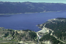
535:
534:
527:
516:
511:
509:
506:
498:Tamarack Resort
495:
493:Tamarack Resort
485:adopted in the
466:
414:
390:smallmouth bass
382:
216:Zoned earthfill
187:
185:
182:
150:
148:
144:
141:
136:
133:
131:
129:
128:
96:
95:
94:
93:
90:
89:
86:
85:
84:
67:
66:
65:
62:
61:
58:
57:
56:
34:
17:
12:
11:
5:
767:
765:
757:
756:
751:
746:
741:
736:
731:
726:
721:
711:
710:
707:
706:
700:
694:
688:
680:
679:External links
677:
674:
673:
641:
612:
602:. pp. A1+
586:
577:
551:
524:
523:
522:
521:
505:
502:
494:
491:
487:drainage basin
465:
462:
413:
410:
394:Kokanee salmon
381:
378:
311:
310:
299:
298:
295:
291:
290:
287:
283:
282:
279:
273:
272:
269:
265:
264:
261:
257:
256:
252:
251:
248:
244:
243:
240:
236:
235:
232:
228:
227:
222:
218:
217:
214:
208:
207:
203:
202:
197:
193:
192:
179:
175:
174:
171:
167:
166:
163:
159:
158:
126:
122:
121:
112:
108:
107:
102:
98:
97:
87:
78:
77:
71:
70:
69:
68:
59:
50:
49:
43:
42:
41:
40:
39:
36:
35:
32:
24:
23:
15:
13:
10:
9:
6:
4:
3:
2:
766:
755:
754:Boise Project
752:
750:
747:
745:
742:
740:
737:
735:
732:
730:
727:
725:
722:
720:
717:
716:
714:
704:
701:
698:
695:
693:— Cascade Dam
692:
689:
686:
683:
682:
678:
662:
658:
651:
645:
642:
630:
626:
622:
616:
613:
601:
597:
590:
587:
581:
578:
567:
563:
562:
555:
552:
539:
532:
530:
526:
519:
508:
503:
501:
499:
492:
490:
489:of the lake.
488:
484:
479:
475:
471:
464:Water quality
463:
461:
459:
456:studying the
455:
451:
447:
443:
439:
435:
431:
427:
423:
419:
411:
409:
407:
403:
399:
395:
391:
387:
379:
377:
375:
371:
366:
364:
360:
356:
352:
348:
344:
343:Valley County
340:
339:Payette River
336:
332:
331:United States
329:
325:
321:
317:
305:
300:
296:
292:
288:
284:
280:
278:
274:
270:
266:
262:
258:
253:
249:
245:
241:
237:
233:
229:
226:
223:
219:
215:
213:
209:
204:
201:
198:
194:
180:
176:
172:
168:
165:Water storage
164:
160:
155:
127:
123:
120:
116:
115:Valley County
113:
109:
106:
105:United States
103:
99:
75:
47:
37:
30:
25:
20:
665:. Retrieved
656:
644:
633:. Retrieved
628:
624:
615:
604:. Retrieved
599:
589:
580:
569:. Retrieved
560:
554:
542:. Retrieved
518:Idaho portal
496:
467:
446:water rights
416:In 2003 the
415:
383:
370:World War II
367:
319:
316:Lake Cascade
315:
314:
263:Lake Cascade
561:Cascade Dam
430:Pikeminnows
402:ice fishing
398:Coho salmon
149: /
137:116°03′04″W
125:Coordinates
33:Cascade Dam
22:Cascade Dam
713:Categories
667:2007-07-08
635:2007-07-08
606:2007-07-08
571:2010-08-19
504:References
478:phosphorus
438:irrigation
424:, such as
422:sport fish
380:Recreation
335:North Fork
318:(formerly
173:1942, 1946
134:44°31′26″N
434:predators
333:, on the
324:reservoir
322:), is a
255:Reservoir
544:March 2,
458:drawdown
359:Donnelly
221:Impounds
196:Owner(s)
111:Location
355:Cascade
337:of the
328:western
326:in the
260:Creates
186: (
162:Purpose
101:Country
448:. The
396:, and
363:McCall
361:, and
239:Length
231:Height
653:(PDF)
470:bloom
442:power
426:perch
386:trout
347:Idaho
119:Idaho
546:2013
188:1948
181:1948
661:EPA
472:of
341:in
715::
659:.
655:.
629:69
627:.
623:.
598:.
564:.
528:^
428:.
392:,
388:,
357:,
345:,
117:,
670:.
638:.
609:.
574:.
548:.
190:)
Text is available under the Creative Commons Attribution-ShareAlike License. Additional terms may apply.