145:
175:
401:
22:
182:
152:
131:
412:
Lake
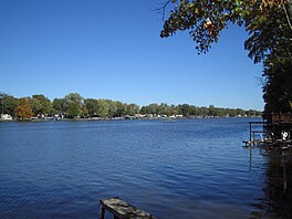
Freeman is roughly 1,500 acres (6 km) in area and has a shoreline of 50 miles (80 km). Depths vary from 7 feet (2 m) to 45 feet (14 m) at the Oakdale Dam. According to his widow, it was named for Rhode Island civil engineer Roger Morse Freeman who was involved in many well
390:. The earthen dam is 58 feet (18 m) high, has a maximum capacity of 40,540 acre-feet (50,010,000 m), normal capacity of 26,140 acre-feet (32,240,000 m), and is owned by the Northern Indiana Public Service Company.
489:
469:
479:
144:
174:
393:
Compared to the more commercial lake, Lake Shafer, Lake
Freeman remains more privatized and residential. Lake Freeman, is however, home of the
230:
105:
484:
440:
464:
43:
86:
39:
58:
65:
413:
known projects; his father John R. Freeman, who he started his career with, was an internationally known engineer.
32:
474:
72:
54:
288:
207:
386:
Construction of the
Oakdale Dam began in 1923 and was completed in 1925, damming the waters of the
380:
368:
274:
397:, a pleasure excursion vessel, 36 feet (11 m) in width and 135 feet (41 m) in length.
400:
379:
is part of the Twin Lakes region, a popular summer recreational area centered on the town of
387:
295:
281:
79:
416:
302:
458:
308:
262:
216:
444:
420:
376:
21:
130:
245:
232:
364:
267:
275:
211:
289:
399:
15:
350:
342:
334:
326:
318:
314:
301:
287:
273:
261:
222:
203:
123:
46:. Unsourced material may be challenged and removed.
375:. Lake Freeman, together with its sister lake,
223:
8:
120:
106:Learn how and when to remove this message
490:Bodies of water of White County, Indiana
470:Protected areas of White County, Indiana
371:formed in 1925 by the completion of the
480:United States local public utility dams
432:
7:
181:
151:
44:adding citations to reliable sources
118:Reservoir in Indiana, United States
14:
180:
173:
150:
143:
129:
20:
349:
341:
333:
325:
317:
31:needs additional citations for
423:is named after Lake Freeman.
1:
202:
194:Show map of the United States
506:
330:1,500 acres (610 ha)
137:
128:
354:610 ft (190 m)
338:16 ft (4.9 m)
322:12 mi (19 km)
485:Dams completed in 1925
409:
346:45 ft (14 m)
465:Reservoirs in Indiana
403:
40:improve this article
381:Monticello, Indiana
369:Monticello, Indiana
246:40.6927°N 86.7589°W
242: /
164:Show map of Indiana
410:
358:
357:
351:Surface elevation
251:40.6927; -86.7589
116:
115:
108:
90:
497:
449:
448:
443:. Archived from
437:
388:Tippecanoe River
296:Tippecanoe River
291:
290:Primary outflows
282:Tippecanoe River
277:
257:
256:
254:
253:
252:
247:
243:
240:
239:
238:
235:
225:
195:
184:
183:
177:
165:
154:
153:
147:
133:
121:
111:
104:
100:
97:
91:
89:
48:
24:
16:
505:
504:
500:
499:
498:
496:
495:
494:
475:Dams in Indiana
455:
454:
453:
452:
439:
438:
434:
429:
408:on Lake Freeman
305: countries
276:Primary inflows
250:
248:
244:
241:
236:
233:
231:
229:
228:
215:
199:
198:
197:
196:
193:
192:
191:
190:
189:
185:
168:
167:
166:
163:
162:
161:
160:
159:
155:
119:
112:
101:
95:
92:
49:
47:
37:
25:
12:
11:
5:
503:
501:
493:
492:
487:
482:
477:
472:
467:
457:
456:
451:
450:
447:on 2011-08-25.
431:
430:
428:
425:
356:
355:
352:
348:
347:
344:
340:
339:
336:
332:
331:
328:
324:
323:
320:
316:
315:
312:
311:
306:
299:
298:
293:
285:
284:
279:
271:
270:
265:
259:
258:
226:
220:
219:
205:
201:
200:
187:
186:
179:
178:
172:
171:
170:
169:
157:
156:
149:
148:
142:
141:
140:
139:
138:
135:
134:
126:
125:
117:
114:
113:
55:"Lake Freeman"
28:
26:
19:
13:
10:
9:
6:
4:
3:
2:
502:
491:
488:
486:
483:
481:
478:
476:
473:
471:
468:
466:
463:
462:
460:
446:
442:
436:
433:
426:
424:
422:
418:
417:Freeman Lacus
414:
407:
406:Madam Carroll
402:
398:
396:
395:Madam Carroll
391:
389:
384:
382:
378:
374:
370:
366:
362:
353:
345:
337:
335:Average depth
329:
321:
313:
310:
309:United States
307:
304:
300:
297:
294:
292:
286:
283:
280:
278:
272:
269:
266:
264:
260:
255:
227:
221:
218:
217:United States
213:
209:
206:
176:
146:
136:
132:
127:
122:
110:
107:
99:
88:
85:
81:
78:
74:
71:
67:
64:
60:
57: –
56:
52:
51:Find sources:
45:
41:
35:
34:
29:This article
27:
23:
18:
17:
445:the original
435:
415:
411:
405:
394:
392:
385:
372:
361:Lake Freeman
360:
359:
327:Surface area
208:White County
188:Lake Freeman
158:Lake Freeman
124:Lake Freeman
102:
96:October 2014
93:
83:
76:
69:
62:
50:
38:Please help
33:verification
30:
377:Lake Shafer
373:Oakdale Dam
367:outside of
319:Max. length
249: /
224:Coordinates
459:Categories
427:References
343:Max. depth
237:86°45′32″W
234:40°41′34″N
66:newspapers
441:"Oakdale"
365:reservoir
268:reservoir
204:Location
212:Indiana
80:scholar
82:
75:
68:
61:
53:
421:Titan
363:is a
303:Basin
87:JSTOR
73:books
404:The
263:Type
59:news
419:on
42:by
461::
383:.
210:,
214:,
109:)
103:(
98:)
94:(
84:·
77:·
70:·
63:·
36:.
Text is available under the Creative Commons Attribution-ShareAlike License. Additional terms may apply.