155:
377:
22:
162:
139:
353:. The dam was completed in 1952 with the purpose to regulate water flow of the Yaqui River, prevent floods, and generate electricity. Lake Ouiachic is also an expanding tourist and resort area specializing in
449:
425:
209:
459:
154:
316:
113:
43:
94:
464:
66:
47:
444:
418:
387:
73:
454:
32:
80:
51:
36:
411:
62:
346:
342:
183:
267:
253:
87:
395:
281:
376:
438:
241:
362:
350:
274:
260:
21:
224:
211:
246:
358:
354:
322:
254:
268:
391:
384:
326:
195:
191:
187:
138:
15:
399:
315:
311:
303:
295:
291:
280:
266:
252:
240:
201:
179:
131:
202:
419:
349:. Lake Ouiachic is fed by and drained by the
8:
50:. Unsourced material may be challenged and
426:
412:
128:
114:Learn how and when to remove this message
450:Landforms of the Sierra Madre Occidental
383:This article about a location in the
341:) is located in the foothills of the
161:
7:
373:
371:
48:adding citations to reliable sources
398:. You can help Knowledge (XXG) by
14:
375:
160:
153:
137:
20:
302:
294:
1:
460:Tourist attractions in Sonora
178:
299:19.6 km (12.2 mi)
126:Reservoir in Sonora, Mexico
481:
370:
337:(also referred to as the
307:7.8 km (4.8 mi)
148:
136:
339:Álvaro Obregón Reservoir
143:from space, October 1994
343:Sierra Madre Occidental
184:Sierra Madre Occidental
465:Sonora geography stubs
345:and is created by the
445:Reservoirs in Mexico
225:27.8722°N 109.8640°W
44:improve this article
455:Landforms of Sonora
221: /
347:Álvaro Obregón Dam
230:27.8722; -109.8640
407:
406:
332:
331:
124:
123:
116:
98:
472:
428:
421:
414:
379:
372:
270:
269:Primary outflows
256:
236:
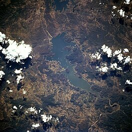
235:
233:
232:
231:
226:
222:
219:
218:
217:
214:
204:
164:
163:
157:
141:
129:
119:
112:
108:
105:
99:
97:
56:
24:
16:
480:
479:
475:
474:
473:
471:
470:
469:
435:
434:
433:
432:
368:
284: countries
255:Primary inflows
229:
227:
223:
220:
215:
212:
210:
208:
207:
175:
174:
173:
172:
171:
170:
169:
165:
144:
127:
120:
109:
103:
100:
63:"Lake Oviáchic"
57:
55:
41:
25:
12:
11:
5:
478:
476:
468:
467:
462:
457:
452:
447:
437:
436:
431:
430:
423:
416:
408:
405:
404:
380:
330:
329:
319:
313:
312:
309:
308:
305:
301:
300:
297:
293:
292:
289:
288:
285:
278:
277:
272:
264:
263:
258:
250:
249:
244:
238:
237:
205:
199:
198:
181:
177:
176:
167:
166:
159:
158:
152:
151:
150:
149:
146:
145:
142:
134:
133:
125:
122:
121:
28:
26:
19:
13:
10:
9:
6:
4:
3:
2:
477:
466:
463:
461:
458:
456:
453:
451:
448:
446:
443:
442:
440:
429:
424:
422:
417:
415:
410:
409:
403:
401:
397:
393:
389:
386:
381:
378:
374:
369:
366:
364:
360:
356:
352:
348:
344:
340:
336:
335:Lake Ouiachic
328:
324:
320:
318:
314:
310:
306:
298:
290:
286:
283:
279:
276:
273:
271:
265:
262:
259:
257:
251:
248:
245:
243:
239:
234:
206:
200:
197:
193:
189:
185:
182:
168:Lake Ouiachic
156:
147:
140:
135:
132:Lake Ouiachic
130:
118:
115:
107:
104:December 2009
96:
93:
89:
86:
82:
79:
75:
72:
68:
65: –
64:
60:
59:Find sources:
53:
49:
45:
39:
38:
34:
29:This article
27:
23:
18:
17:
400:expanding it
382:
367:
363:water skiing
338:
334:
333:
110:
101:
91:
84:
77:
70:
58:
42:Please help
30:
351:Yaqui River
296:Max. length
275:Yaqui River
261:Yaqui River
228: /
216:109°51′50″W
203:Coordinates
439:Categories
304:Max. width
213:27°52′20″N
74:newspapers
321:numerous
247:reservoir
31:does not
180:Location
385:Mexican
359:boating
355:fishing
323:islands
317:Islands
88:scholar
52:removed
37:sources
392:Sonora
361:, and
327:islets
287:Mexico
196:Mexico
192:Sonora
188:Cajeme
90:
83:
76:
69:
61:
394:is a
388:state
282:Basin
95:JSTOR
81:books
396:stub
325:and
242:Type
67:news
35:any
33:cite
390:of
46:by
441::
365:.
357:,
194:,
190:,
186:,
427:e
420:t
413:v
402:.
117:)
111:(
106:)
102:(
92:·
85:·
78:·
71:·
54:.
40:.
Text is available under the Creative Commons Attribution-ShareAlike License. Additional terms may apply.
↑