221:
232:. The river descends gradually until the Waipori Gorge, where it suddenly drops 222 metres (728 ft) in approximately 4,000 metres (13,000 ft). This makes the gorge an ideal site for a hydro-electric scheme. The first proposals to develop the river for hydro-electric generation were prepared in 1900, for powering gold mining dredges. However, the plans were eventually altered to supply power to Dunedin city and surrounding districts. Construction began in early 1903.
47:
829:
857:
31:
843:
54:
247:
There was opposition from gold mining interests that blocked the development of storage capacity on the
Waipori River itself, because Waipori Flat was still being actively mined. In 1920, the Dunedin City Corporation Empowering Act was successfully pushed through Parliament, against opposition from
239:
substation in
Dunedin via two 33 kV lines. However, there was no storage built into the original scheme, and in the first year of operation, low flows in the river led to constraints on the generating capacity. Between 1907 and 1913, some storage lakes were created on tributaries, including an
251:
The first dam was built in 1923, and later raised, but ultimately had to be abandoned because of inadequate foundations. A second
Empowering Act of 1924 enabled another dam to be built further downstream, with work beginning in 1927, and completing in 1931. Lake Mahinerangi was formed by this new
255:
The
Mahinerangi Dam was completed to its final height of 33.5 metres (110 ft) in 1946. By 1955, two more generating stations had been built downstream from the original powerhouse. There have been further replacements and additions to generating capacity between the 1960s and 1980s.
275:
The lake is well stocked with brown trout and some perch. The elevation is nearly 2,000 feet (610 m) and the lake can be very windswept and cold, which makes the fishery best suited to the warmer months.
252:
20.4-metre (67 ft) high dam, and an additional powerhouse of 3,000 kilowatts (4,000 hp) capacity was commissioned. The new lake submerged the mining township of
Waipori.
925:
730:
259:
The
Waipori hydro-electric scheme includes a network of four dams and power stations and produces a maximum output of 84 megawatts (113,000 hp).
697:
901:
97:
46:
882:
209:
777:
204:
in 1911 and 1912. The lake has a maximum length of 12 kilometres (7.5 mi), and lies on the western side of
197:
920:
862:
930:
288:
220:
877:(Second ed.). Wellington: Bridget Williams Books Ltd and Electricity Corporation of New Zealand.
654:
752:
834:
897:
878:
659:
201:
177:
235:
The generating plant commenced operation on 27 April 1907. Electricity was transmitted to
229:
75:
248:
mining interests, to enable the use of the
Waipori River as a hydro-electric reservoir.
141:
267:
At the southern end, the lake has two major arms, called Loch Luella and Loch Loudon.
914:
303:
Climate data for
Mahinerangi Dam , elevation 396 m (1,299 ft), (1981–2010)
196:
The lake was named for
Dorothy Kathleen Mahinerangi Burnett. She was the daughter of
173:
875:
People, Power and Power
Stations: Electric Power Generation in New Zealand 1880–1990
753:"Lake Mahinerangi Dam and Power Station – Waipori Falls, Otago – Dayout New Zealand"
848:
236:
188:. Construction of the dam started in 1903 and since 1907, power has been produced.
185:
83:
856:
824:
693:
284:
30:
112:
99:
842:
205:
134:
212:. It is surrounded by farmland, tussock grasslands, and plantation forest.
241:
181:
219:
180:
generation. The lake is 35 kilometres (22 mi) to the west of
79:
169:
129:
894:
Connecting the Country: New Zealand's National Grid 1886–2007
799:
800:"CliFlo – National Climate Database : Ranfurly Ews"
155:
151:
140:
128:
89:
71:
23:
228:The tributaries of the Waipori River are in the
90:
8:
772:
770:
926:Hydroelectric power stations in New Zealand
299:
20:
53:
698:Te Ara: The Encyclopedia of New Zealand
645:
18:Reservoir in Otago Region, South Island
717:
680:
653:Constantine, Ellie (8 January 2009).
291:is located to the north of the lake.
7:
172:formed when a dam was built on the
14:
655:"Haven at end of road to nowhere"
855:
841:
827:
52:
45:
29:
208:, above and to the west of the
154:
896:. Wellington: Steele Roberts.
632:Source: NIWA (rain 1971–2000)
1:
562:Average rainfall mm (inches)
70:
873:Martin, John E, ed. (1998).
492:Mean daily minimum °C (°F)
352:Mean daily maximum °C (°F)
947:
631:
302:
216:Hydro-electric development
561:
491:
421:
351:
346:
343:
340:
337:
334:
331:
328:
325:
322:
319:
316:
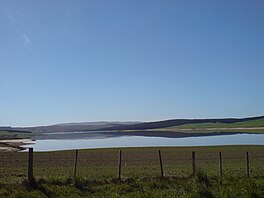
313:
310:
307:
40:
28:
159:12 km (7.5 mi)
863:Renewable energy portal
733:. NZ: Travelingluck.com
694:"Otago places – Taieri"
892:Reilly, Helen (2008).
225:
289:Mahinerangi Wind Farm
223:
422:Daily mean °C (°F)
109: /
835:New Zealand portal
778:"Lake Mahinerangi"
731:"Lake Mahinerangi"
244:on Pioneer Creek.
226:
113:45.867°S 169.950°E
903:978-1-877448-40-9
720:, pp. 33–36.
683:, pp. 29–30.
660:Otago Daily Times
636:
635:
184:in New Zealand's
163:
162:
938:
907:
888:
865:
860:
859:
851:
846:
845:
837:
832:
831:
830:
812:
811:
809:
807:
796:
790:
789:
787:
785:
774:
765:
764:
762:
760:
749:
743:
742:
740:
738:
727:
721:
715:
709:
708:
706:
704:
690:
684:
678:
672:
671:
669:
667:
650:
300:
202:mayor of Dunedin
166:Lake Mahinerangi
124:
123:
121:
120:
119:
118:-45.867; 169.950
114:
110:
107:
106:
105:
102:
92:
60:Lake Mahinerangi
56:
55:
49:
35:Lake Mahinerangi
33:
24:Lake Mahinerangi
21:
946:
945:
941:
940:
939:
937:
936:
935:
911:
910:
904:
891:
885:
872:
869:
868:
861:
854:
847:
840:
833:
828:
826:
821:
816:
815:
805:
803:
798:
797:
793:
783:
781:
780:. Nzfishing.com
776:
775:
768:
758:
756:
751:
750:
746:
736:
734:
729:
728:
724:
716:
712:
702:
700:
692:
691:
687:
679:
675:
665:
663:
652:
651:
647:
642:
637:
626:
621:
616:
611:
606:
601:
596:
591:
586:
581:
576:
571:
566:
556:
551:
546:
541:
536:
531:
526:
521:
516:
511:
506:
501:
496:
486:
481:
476:
471:
466:
461:
456:
451:
446:
441:
436:
431:
426:
416:
411:
406:
401:
396:
391:
386:
381:
376:
371:
366:
361:
356:
297:
282:
273:
265:
240:early concrete
230:Lammerlaw Range
224:Mahinerangi Dam
218:
198:William Burnett
194:
144: countries
117:
115:
111:
108:
103:
100:
98:
96:
95:
76:Clutha District
67:
66:
65:
64:
63:
62:
61:
57:
36:
19:
12:
11:
5:
944:
942:
934:
933:
928:
923:
921:Lakes of Otago
913:
912:
909:
908:
902:
889:
883:
867:
866:
852:
838:
823:
822:
820:
817:
814:
813:
791:
766:
755:. Dayout.co.nz
744:
722:
710:
685:
673:
644:
643:
641:
638:
634:
633:
629:
628:
623:
618:
613:
608:
603:
598:
593:
588:
583:
578:
573:
568:
563:
559:
558:
553:
548:
543:
538:
533:
528:
523:
518:
513:
508:
503:
498:
493:
489:
488:
483:
478:
473:
468:
463:
458:
453:
448:
443:
438:
433:
428:
423:
419:
418:
413:
408:
403:
398:
393:
388:
383:
378:
373:
368:
363:
358:
353:
349:
348:
345:
342:
339:
336:
333:
330:
327:
324:
321:
318:
315:
312:
309:
305:
304:
298:
296:
293:
281:
278:
272:
269:
264:
261:
217:
214:
210:Berwick Forest
193:
190:
161:
160:
157:
153:
152:
149:
148:
145:
138:
137:
132:
126:
125:
93:
87:
86:
73:
69:
68:
59:
58:
51:
50:
44:
43:
42:
41:
38:
37:
34:
26:
25:
17:
13:
10:
9:
6:
4:
3:
2:
943:
932:
929:
927:
924:
922:
919:
918:
916:
905:
899:
895:
890:
886:
880:
876:
871:
870:
864:
858:
853:
850:
844:
839:
836:
825:
818:
801:
795:
792:
779:
773:
771:
767:
754:
748:
745:
732:
726:
723:
719:
714:
711:
699:
695:
689:
686:
682:
677:
674:
662:
661:
656:
649:
646:
639:
630:
624:
619:
614:
609:
604:
599:
594:
589:
584:
579:
574:
569:
564:
560:
554:
549:
544:
539:
534:
529:
524:
519:
514:
509:
504:
499:
494:
490:
484:
479:
474:
469:
464:
459:
454:
449:
444:
439:
434:
429:
424:
420:
414:
409:
404:
399:
394:
389:
384:
379:
374:
369:
364:
359:
354:
350:
306:
301:
294:
292:
290:
286:
279:
277:
270:
268:
262:
260:
257:
253:
249:
245:
243:
238:
233:
231:
222:
215:
213:
211:
207:
203:
199:
191:
189:
187:
183:
179:
178:hydroelectric
175:
174:Waipori River
171:
167:
158:
150:
146:
143:
139:
136:
133:
131:
127:
122:
94:
88:
85:
81:
77:
74:
48:
39:
32:
27:
22:
16:
931:Taieri River
893:
884:0-908912-986
874:
849:Water portal
804:. Retrieved
794:
782:. Retrieved
757:. Retrieved
747:
735:. Retrieved
725:
713:
701:. Retrieved
688:
676:
664:. Retrieved
658:
648:
283:
274:
266:
258:
254:
250:
246:
237:Halfway Bush
234:
227:
195:
186:South Island
165:
164:
84:South Island
80:Otago Region
15:
718:Martin 1998
681:Reilly 2008
156:Max. length
147:New Zealand
116: /
91:Coordinates
915:Categories
819:References
285:Trustpower
200:, who was
280:Wind farm
206:Maungatua
135:reservoir
130:Lake type
784:12 March
759:12 March
737:12 March
703:21 April
666:12 March
242:arch dam
104:169°57′E
72:Location
627:(40.2)
625:1,020.9
622:(3.94)
617:(2.55)
612:(3.43)
607:(2.78)
602:(3.09)
597:(3.76)
592:(3.81)
587:(4.63)
582:(2.83)
577:(3.17)
572:(2.99)
567:(3.22)
557:(39.1)
552:(44.2)
547:(41.0)
542:(38.1)
537:(35.4)
532:(32.7)
527:(30.7)
522:(33.4)
517:(36.5)
512:(40.5)
507:(43.7)
502:(46.4)
497:(46.8)
487:(47.4)
482:(52.9)
477:(50.0)
472:(47.1)
467:(44.1)
462:(40.5)
457:(38.1)
452:(40.1)
447:(43.7)
442:(48.6)
437:(52.5)
432:(55.2)
427:(55.9)
417:(55.7)
412:(61.7)
407:(59.2)
402:(56.1)
397:(52.9)
392:(48.0)
387:(45.3)
382:(46.6)
377:(51.1)
372:(56.8)
367:(61.2)
362:(64.2)
357:(65.3)
295:Climate
271:Fishing
182:Dunedin
101:45°52′S
900:
881:
806:19 May
802:. NIWA
308:Month
192:Naming
640:Notes
620:100.1
585:117.5
347:Year
168:is a
142:Basin
898:ISBN
879:ISBN
808:2024
786:2012
761:2012
739:2012
705:2012
668:2012
615:64.7
610:87.1
605:70.7
600:78.4
595:95.6
590:96.8
580:71.9
575:80.4
570:76.0
565:81.7
525:−0.7
480:11.6
475:10.0
435:11.4
430:12.9
425:13.3
415:13.2
410:16.5
405:15.1
400:13.4
395:11.6
375:10.6
370:13.8
365:16.2
360:17.9
355:18.5
344:Dec
341:Nov
338:Oct
335:Sep
332:Aug
329:Jul
326:Jun
323:May
320:Apr
317:Mar
314:Feb
311:Jan
263:Arms
176:for
170:lake
555:4.0
550:6.8
545:5.0
540:3.4
535:1.9
530:0.4
520:0.8
515:2.5
510:4.7
505:6.5
500:8.0
495:8.2
485:8.5
470:8.4
465:6.7
460:4.7
455:3.4
450:4.5
445:6.5
440:9.2
390:8.9
385:7.4
380:8.1
287:'s
917::
769:^
696:.
657:.
82:,
78:,
906:.
887:.
810:.
788:.
763:.
741:.
707:.
670:.
Text is available under the Creative Commons Attribution-ShareAlike License. Additional terms may apply.