78:
276:
268:
462:
476:
322:
permanent flooding following dam construction. The lakes are deep and there are large areas of open water without aquatic plants. The large fluctuation in water levels in Lake Argyle has prevented vegetation establishment along most of the shoreline. However, because water levels are stable in Lake
Kununurra and its associated wetlands, they have developed densely vegetated margins, with aquatic plants fringed by
260:
85:
50:
297:
on the Ord River was completed in 1963 as the first stage of the Ord River
Irrigation Scheme. It flooded the Ord valley upstream towards the site of the Argyle Dam, creating Lake Kununurra and subsidiary wetlands such as Lily Creek Lagoon and the Packsaddle Swamps. The Argyle Dam was completed in
321:
Water levels in Lake Argyle fluctuate annually by about 3 metres (9.8 ft) but those in Lake
Kununurra and its associated wetlands are kept constant except for short periods when levels are lowered to control weed growth. There are dead trees throughout the wetland system which were killed by
960:
380:, with regular numbers of over 20,000 and sometimes of up to 200,000 individuals. Lake Argyle contains some of the largest aggregations of waterbirds in northern Australia. Abundant species include
77:
1076:
518:
637:
829:
118:
247:. There are numerous endemic plants and a rich fauna. The 1,500 km (580 sq mi) site was designated a wetland of international importance under the
610:
892:
998:
1107:
575:
491:
630:
522:
685:
1122:
1053:
897:
857:
834:
1112:
623:
710:
662:
646:
1008:
814:
776:
1066:
690:
302:
was built at the site of the diversion dam, adjoining Lake
Kununurra and Lily Creek Lagoon. Human use of the area includes
232:
1071:
945:
654:
299:
111:
867:
680:
428:. Over 200 terrestrial and aquatic bird species have been recorded in the area, which also supports several kinds of
930:
735:
950:
781:
467:
389:
365:
348:
700:
1043:
965:
940:
882:
819:
582:
988:
877:
445:
433:
393:
343:
338:
1023:
920:
758:
306:
1028:
425:
310:
1117:
862:
786:
745:
481:
401:
353:
275:
267:
259:
993:
980:
753:
715:
549:
417:
248:
236:
174:
99:
40:
912:
475:
437:
359:
935:
902:
806:
725:
695:
672:
409:
397:
17:
1081:
955:
796:
288:
244:
63:
1101:
1086:
1038:
824:
421:
294:
1061:
970:
925:
887:
872:
705:
385:
1033:
791:
730:
720:
381:
284:
240:
55:
768:
457:
373:
303:
220:
133:
120:
1018:
1003:
839:
615:
405:
377:
327:
228:
59:
298:
1972 as the second stage of the scheme, creating Lake Argyle. The town of
849:
429:
413:
334:
49:
331:
224:
441:
521:. The Ramsar Convention on Wetlands. 4 January 2000. Archived from
576:"Information Sheet on Ramsar Wetlands: Lakes Argyle and Kununurra"
544:
323:
274:
266:
258:
619:
84:
337:. Tree species found on the wetland margins include
313:, and with tourism becoming increasingly important.
1052:
979:
911:
848:
805:
767:
744:
671:
653:
197:
189:
181:
172:
165:
157:
149:
110:
34:
424:(50,000). The two lakes are a stronghold of the
830:Coorong and Lakes Alexandrina and Albert Wetland
492:List of reservoirs and dams in Western Australia
581:. Wetlands International. 1998. Archived from
631:
8:
611:Lakes Argyle and Kununurra Ramsar Site – map
223:reservoirs, with their associated permanent
219:comprises an extensive system of artificial
251:on 7 June 1990, making it Ramsar Site 478.
638:
624:
616:
48:
31:
58:from space, looking south-east, with the
961:Port Phillip Bay and Bellarine Peninsula
503:
519:"The Annotated Ramsar List: Australia"
217:Lakes Argyle and Kununurra Ramsar Site
91:Lakes Argyle and Kununurra Ramsar Site
36:Lakes Argyle and Kununurra Ramsar Site
863:Cape Barren Island east coast lagoons
570:
568:
513:
511:
509:
507:
196:
188:
180:
171:
161:1,500 km (579.2 sq mi)
7:
29:Protected area in Western Australia
25:
1082:Hosnies Spring (Christmas Island)
474:
460:
83:
76:
1108:Reservoirs in Western Australia
815:Banrock Station Wetland Complex
999:Forrestdale and Thomsons Lakes
691:Fivebough and Tuckerbil Swamps
311:diamond mining and exploration
1:
1077:Elizabeth and Middleton Reefs
1123:Kununurra, Western Australia
1072:The Dales (Christmas Island)
655:Australian Capital Territory
545:"Lakes Argyle and Kununurra"
384:(with up to 6,000 counted),
372:The lakes form an important
868:Interlaken Lakeside Reserve
231:in the eastern part of the
1139:
1014:Lakes Argyle and Kununurra
931:Edithvale-Seaford Wetlands
282:
239:. The reservoirs include
185:Lakes Argyle and Kununurra
18:Lakes Argyle and Kununurra
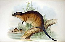
1113:Ramsar sites in Australia
903:Pittwater–Orielton Lagoon
711:Little Llangothlin Lagoon
647:Ramsar sites in Australia
552:Sites Information Service
209:
205:
71:
47:
468:Western Australia portal
390:wandering whistling duck
366:Lophostemon grandiflorus
227:, formed by damming the
701:Hunter Estuary Wetlands
444:, and large numbers of
966:Western District Lakes
893:Lower Ringarooma River
883:Little Waterhouse Lake
820:Bool and Hacks Lagoons
686:Central Murray Forests
339:broad-leaved paperbark
280:
272:
264:
1044:Vasse-Wonnerup System
989:Becher Point Wetlands
446:freshwater crocodiles
394:plumed whistling duck
344:Eucalyptus microtheca
278:
270:
262:
1054:External territories
1029:Peel-Yalgorup System
1024:Ord River Floodplain
946:Hattah-Kulkyne Lakes
759:Kakadu National Park
525:on 19 September 2011
307:tropical agriculture
279:Freshwater crocodile
271:Rakali, or water-rat
426:comb-crested jacana
235:region of northern
130: /
1067:Coral Sea Reserves
1019:Muir-Byenup System
1009:Lake Warden System
787:Great Sandy Strait
746:Northern Territory
482:Environment portal
438:black flying-foxes
402:Pacific black duck
354:Nauclea orientalis
281:
273:
265:
198:Reference no.
134:16.317°S 128.733°E
1095:
1094:
994:Eighty Mile Beach
981:Western Australia
835:Piccaninnie Ponds
777:Bowling Green Bay
754:Cobourg Peninsula
716:Macquarie Marshes
418:green pygmy goose
249:Ramsar Convention
237:Western Australia
213:
212:
100:Western Australia
41:Western Australia
16:(Redirected from
1130:
971:Western Port Bay
782:Currawinya Lakes
640:
633:
626:
617:
598:
597:
595:
593:
587:
580:
572:
563:
562:
560:
558:
541:
535:
534:
532:
530:
515:
484:
479:
478:
470:
465:
464:
463:
360:Sesbania formosa
145:
144:
142:
141:
140:
139:-16.317; 128.733
135:
131:
128:
127:
126:
123:
87:
86:
80:
52:
43:
37:
32:
21:
1138:
1137:
1133:
1132:
1131:
1129:
1128:
1127:
1098:
1097:
1096:
1091:
1048:
975:
951:Kerang Wetlands
941:Gunbower Forest
936:Gippsland Lakes
907:
898:Moulting Lagoon
844:
807:South Australia
801:
763:
740:
726:Narran Wetlands
696:Gwydir Wetlands
673:New South Wales
667:
649:
644:
607:
602:
601:
591:
589:
588:on 22 June 2011
585:
578:
574:
573:
566:
556:
554:
543:
542:
538:
528:
526:
517:
516:
505:
500:
488:
487:
480:
473:
466:
461:
459:
454:
410:pink-eared duck
398:radjah shelduck
319:
317:Flora and fauna
291:
283:Main articles:
263:Radjah shelduck
257:
177:
138:
136:
132:
129:
124:
121:
119:
117:
116:
106:
105:
104:
103:
102:
95:
94:
93:
92:
88:
67:
39:
38:
35:
30:
23:
22:
15:
12:
11:
5:
1136:
1134:
1126:
1125:
1120:
1115:
1110:
1100:
1099:
1093:
1092:
1090:
1089:
1084:
1079:
1074:
1069:
1064:
1058:
1056:
1050:
1049:
1047:
1046:
1041:
1036:
1031:
1026:
1021:
1016:
1011:
1006:
1001:
996:
991:
985:
983:
977:
976:
974:
973:
968:
963:
958:
956:Lake Albacutya
953:
948:
943:
938:
933:
928:
923:
917:
915:
909:
908:
906:
905:
900:
895:
890:
885:
880:
875:
870:
865:
860:
858:Apsley Marshes
854:
852:
846:
845:
843:
842:
837:
832:
827:
822:
817:
811:
809:
803:
802:
800:
799:
797:Shoalwater Bay
794:
789:
784:
779:
773:
771:
765:
764:
762:
761:
756:
750:
748:
742:
741:
739:
738:
733:
731:Paroo Wetlands
728:
723:
718:
713:
708:
703:
698:
693:
688:
683:
677:
675:
669:
668:
666:
665:
659:
657:
651:
650:
645:
643:
642:
635:
628:
620:
614:
613:
606:
605:External links
603:
600:
599:
564:
536:
502:
501:
499:
496:
495:
494:
486:
485:
471:
456:
455:
453:
450:
318:
315:
289:Lake Kununurra
256:
253:
245:Lake Kununurra
211:
210:
207:
206:
203:
202:
199:
195:
194:
191:
187:
186:
183:
179:
178:
175:Ramsar Wetland
173:
170:
169:
167:
163:
162:
159:
155:
154:
151:
147:
146:
114:
108:
107:
97:
96:
90:
89:
82:
81:
75:
74:
73:
72:
69:
68:
64:Lake Kununurra
53:
45:
44:
28:
24:
14:
13:
10:
9:
6:
4:
3:
2:
1135:
1124:
1121:
1119:
1116:
1114:
1111:
1109:
1106:
1105:
1103:
1088:
1085:
1083:
1080:
1078:
1075:
1073:
1070:
1068:
1065:
1063:
1060:
1059:
1057:
1055:
1051:
1045:
1042:
1040:
1039:Toolibin Lake
1037:
1035:
1032:
1030:
1027:
1025:
1022:
1020:
1017:
1015:
1012:
1010:
1007:
1005:
1002:
1000:
997:
995:
992:
990:
987:
986:
984:
982:
978:
972:
969:
967:
964:
962:
959:
957:
954:
952:
949:
947:
944:
942:
939:
937:
934:
932:
929:
927:
924:
922:
921:Barmah Forest
919:
918:
916:
914:
910:
904:
901:
899:
896:
894:
891:
889:
886:
884:
881:
879:
876:
874:
871:
869:
866:
864:
861:
859:
856:
855:
853:
851:
847:
841:
838:
836:
833:
831:
828:
826:
825:Coongie Lakes
823:
821:
818:
816:
813:
812:
810:
808:
804:
798:
795:
793:
790:
788:
785:
783:
780:
778:
775:
774:
772:
770:
766:
760:
757:
755:
752:
751:
749:
747:
743:
737:
734:
732:
729:
727:
724:
722:
719:
717:
714:
712:
709:
707:
704:
702:
699:
697:
694:
692:
689:
687:
684:
682:
679:
678:
676:
674:
670:
664:
661:
660:
658:
656:
652:
648:
641:
636:
634:
629:
627:
622:
621:
618:
612:
609:
608:
604:
584:
577:
571:
569:
565:
553:
551:
546:
540:
537:
524:
520:
514:
512:
510:
508:
504:
497:
493:
490:
489:
483:
477:
472:
469:
458:
451:
449:
447:
443:
439:
435:
431:
427:
423:
422:Eurasian coot
419:
415:
411:
407:
403:
399:
395:
391:
387:
383:
379:
375:
370:
368:
367:
362:
361:
356:
355:
350:
349:river red gum
346:
345:
340:
336:
333:
329:
325:
316:
314:
312:
308:
305:
301:
296:
295:diversion dam
290:
286:
277:
269:
261:
254:
252:
250:
246:
242:
238:
234:
230:
226:
222:
218:
208:
204:
200:
192:
184:
182:Official name
176:
168:
164:
160:
156:
152:
148:
143:
115:
113:
109:
101:
79:
70:
66:at lower left
65:
61:
57:
51:
46:
42:
33:
27:
19:
1087:Pulu Keeling
1062:Ashmore Reef
1013:
926:Corner Inlet
888:Logan Lagoon
873:Jocks Lagoon
706:Lake Pinaroo
663:Ginini Flats
590:. Retrieved
583:the original
555:. Retrieved
548:
539:
527:. Retrieved
523:the original
420:(1,500) and
386:magpie goose
371:
364:
358:
352:
342:
320:
292:
216:
214:
98:Location in
26:
1034:Roebuck Bay
792:Moreton Bay
736:Towra Point
721:Myall Lakes
382:glossy ibis
376:refuge for
285:Lake Argyle
255:Description
241:Lake Argyle
193:7 June 1990
153:7 June 1990
150:Established
137: /
112:Coordinates
62:valley and
56:Lake Argyle
1102:Categories
769:Queensland
498:References
434:little red
416:(51,400),
408:(17,200),
404:(16,000),
392:(11,000),
388:(10,500),
378:waterbirds
374:dry season
221:freshwater
190:Designated
1118:Ord River
1004:Lake Gore
840:Riverland
681:Blue Lake
430:microbats
412:(1,800),
406:grey teal
396:(4,300),
328:grassland
324:bulrushes
304:irrigated
300:Kununurra
233:Kimberley
229:Ord River
166:Footnotes
60:Ord River
913:Victoria
850:Tasmania
557:25 April
452:See also
414:hardhead
335:woodland
225:wetlands
125:128°44′E
54:View of
878:Lavinia
400:(900),
332:savanna
122:16°19′S
592:13 May
550:Ramsar
529:13 May
442:rakali
432:, the
586:(PDF)
579:(PDF)
594:2010
559:2018
531:2010
436:and
363:and
330:and
293:The
287:and
243:and
215:The
158:Area
201:478
1104::
567:^
547:.
506:^
448:.
440:,
369:.
357:,
351:,
347:,
341:,
326:,
309:,
639:e
632:t
625:v
596:.
561:.
533:.
20:)
Text is available under the Creative Commons Attribution-ShareAlike License. Additional terms may apply.