547:, and parts of the road pass very closely to residential blocks. As a result, some residents have long complained that the road constitutes a noise nuisance. In 2000, the Hong Kong Government announced a policy to implement noise reduction strategies at flyovers that pass close to buildings, including constructing acoustic barriers and resurfacing roads with "low-noise material". Under this policy, the Lai Chi Kok Bridge was resurfaced in the early 2000s. However, the government said that adding noise barriers was not feasible as the road structure cannot support the added weight. Further, it said that there was no space for a separate noise barrier structure, and the barriers would obstruct firefighting in the event of a fire.
37:
336:
927:
467:
announced plans to reclaim Lai Chi Kok Bay, providing a park on the new land to help resolve the scarcity of public recreational space in the area. It said the bay, popular with swimmers, was badly polluted and constituted a health hazard. The bay was subsequently filled in, meaning the bridge no
515:
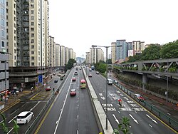
The bridge deck carries three vehicular lanes in each direction. Part of the bridge (the part that spanned the former bay) also has pavements on both sides of the carriageway. There are two slip roads partway along the bridge – one allows eastbound traffic to exit onto
455:
with 99 residential blocks, was developed roughly at the same time. Lai Chi Kok Bridge continues through the estate as an elevated roadway. Various amenities were built under the bridge here, including the community's
441:. Construction began in 1966. Built at a cost of about HK$ 13.5 million, the new bridge, then Hong Kong's longest, was officially opened on 29 October 1968 by acting governor
491:
project, adding new railway platforms and a new ticketing concourse. These new structures were built directly below the Lai Chi Kok Bridge, causing the bridge to shift slightly.
1106:
712:
608:
959:
844:
810:
413:
in some government sources, but confusingly this name is also sometimes used to describe a different flyover farther west on Kwai Chung Road, close to
1239:
968:
916:
994:
1029:
999:
445:. Kwai Chung Road was built along the coastline to the west of the bridge at the same time in order to complete the new link to Kwai Chung.
452:
1097:
878:
1244:
952:
871:
1064:
36:
282:
1249:
945:
374:
54:
931:
597:
1264:
633:
532:
250:
47:
792:
483:
developed the new land directly under the bridge as the Lai Chi Kok Park Stage II. From 1999 to 2003, an extension of
749:"Ground-breaking ceremony held for Sham Shui Po District Council Yan Oi Tong Mei Foo Neighbourhood Activity Centre"
674:
442:
822:
1216:
656:
1208:
1164:
1090:
1004:
464:
111:
556:
426:
1154:
1139:
1059:
1054:
1174:
1181:
1259:
989:
604:
528:
1254:
1114:
1075:
1034:
1009:
984:
517:
504:
351:
194:
121:
1169:
1122:
1083:
979:
748:
500:
182:
907:
544:
448:
378:
1186:
1127:
1014:
521:
469:
438:
414:
382:
503:
together with the former Public Works
Department of the Hong Kong Government, and built by
1191:
1049:
1039:
484:
386:
370:
363:
347:
1203:
1159:
1134:
1044:
531:, the part of the bridge that spanned the bay (i.e. west of the slip roads) registered
488:
335:
1233:
1024:
480:
499:
The bridge is a 2600-foot-long concrete structure with 29 spans. It was designed by
1149:
1144:
473:
849:
97:
457:
434:
359:
69:
56:
430:
305:
101:
926:
312:
405:
in
English. The Transport Department traffic census refers to it as the
937:
355:
872:"Study for Retrofitting Barriers on Existing Roads: Executive Summary"
381:, a private housing estate. The former bay (below the bridge) is now
520:, while the other allows westbound traffic to enter the bridge from
334:
425:
The bridge was built to link
Kowloon with ongoing industrial and
733:"Laichikok Bridge opened today, new traffic routing announced".
675:"Progress of Measures to Address Noise Impact of Existing Roads"
164:
1079:
941:
915:
390:
793:"Review of Payments to Contractors for the West Rail Project"
639:. Hong Kong: Transport Department. August 2017. p. B-27.
476:
to contend with additional loading imposed by the new fill.
317:
903:
898:
821:(5). Hong Kong Institution of Engineers. Archived from
460:, bus terminus, an open plaza, and a community centre.
1175:
Tai Kok Tsui Road
Flyover (West Kowloon Corridor West)
1113:
437:, providing an alternative to the older, congested
369:The bridge, once the longest in Hong Kong, spanned
311:
304:
299:
281:
272:
259:
249:
244:
226:
218:
200:
188:
178:
173:
159:
148:
140:
132:
127:
117:
107:
93:
85:
46:
23:
339:The Mei Foo Bus Terminus, below Lai Chi Kok Bridge
319:Lai6 ji1 gok3 daai6 kiu4 ~y=Laih jī gok daaih kìuh
798:. Kowloon-Canton Railway Corporation. April 2002.
1107:Hong Kong Strategic Route and Exit Number System
722:(30). Scott Wilson Kirkpatrick and Partners: 32.
468:longer spans any water and simply resembles an
1091:
953:
713:"Our Share in the 'Roads and Bridges' Stakes"
287:
8:
696:"H.K.'s longest bridge ready for use soon".
691:
689:
687:
377:. It continues as an elevated road through
1098:
1084:
1076:
960:
946:
938:
650:
648:
646:
501:Scott and Wilson, Kirkpatrick and Partners
296:
183:Scott and Wilson, Kirkpatrick and Partners
20:
920:
657:"Resurfaced flyover should be less noisy"
574:
572:
917:Template:Attached KML/Lai Chi Kok Bridge
762:"Laichikok Bay to be turned into park".
680:. Legislative Council. 24 February 2003.
568:
346:is a Hong Kong bridge that carries the
751:. Hong Kong Government. 29 April 2016.
592:
590:
579:"Laichikok Bridge Is H.K.'s Longest".
269:
7:
711:Maslowicz, Andrew (Christmas 1972).
614:from the original on 25 October 2018
16:Bridge in New Territories, Hong Kong
995:Hong Kong–Shenzhen Western Corridor
879:Environmental Protection Department
401:The name is sometimes rendered as
14:
1240:1968 establishments in Hong Kong
925:
634:"The Annual Traffic Census 2016"
35:
1065:Duplicate Tsing Yi South Bridge
655:Au, Elvis W.K. (3 April 2002).
487:was constructed as part of the
318:
1045:Tseung Kwan O Cross Bay Bridge
779:Scott Wilson Kirkpatrick Today
598:The Annual Traffic Census 2017
288:
160:
149:
1:
1000:Hong Kong–Zhuhai–Macau Bridge
737:. 29 October 1968. p. 6.
700:. 17 October 1968. p. 7.
607:. August 2018. p. B-27.
533:annual average daily traffic
583:. 15 April 1967. p. 1.
206:; 58 years ago
1281:
811:"HKIE Awards – Gold medal"
535:(AADT) of 82,740 in 2017.
1245:Bridges completed in 1968
975:
881:. March 2000. p. 10.
766:. 30 May 1975. p. 6.
443:Michael David Irving Gass
329:
295:
277:
264:
41:Eastern end of the bridge
34:
1182:Tung Chau Street Flyover
990:New Clear Water Bay Road
921:KML is not from Wikidata
764:South China Morning Post
735:South China Morning Post
698:South China Morning Post
661:South China Morning Post
581:South China Morning Post
409:. It is also called the
283:Traditional Chinese
1217:Tsuen Tsing Interchange
1005:Island Eastern Corridor
777:"Further reclamation".
495:Design and construction
411:Kwai Chung Road Flyover
144:2,600 feet (790 m)
1209:Kwai Tsing Interchange
1160:Gascoigne Road Flyover
1030:Rambler Channel Bridge
557:Transport in Hong Kong
472:. The bridge required
453:private housing estate
407:Lai Chi Kok Bay Bridge
340:
232:; 55 years ago
1155:West Kowloon Corridor
1140:East Kowloon Corridor
1060:Tsing Yi South Bridge
1055:Tsing Yi North Bridge
338:
222:HK$ 13.5 million
89:Vehicles, pedestrians
1250:Bridges in Hong Kong
1170:Tong Mi Road Flyover
1165:Ferry Street Flyover
969:Bridges in Hong Kong
934:at Wikimedia Commons
845:"Lai Chi Kok Bridge"
809:Tam, Angela (2013).
605:Transport Department
529:Transport Department
505:Paul Y. Construction
465:Hong Kong Government
391:Mass Transit Railway
230:29 October 1968
195:Paul Y. Construction
112:Hong Kong Government
70:22.3374°N 114.1375°E
1265:Route 5 (Hong Kong)
1035:Stonecutters Bridge
1010:Kap Shui Mun Bridge
985:Cheung Tsing Bridge
543:The bridge bisects
518:Cheung Sha Wan Road
122:Highways Department
66: /
1197:Lai Chi Kok Bridge
1150:Chatham Road South
1145:Chatham Road North
1020:Lai Chi Kok Bridge
980:Ap Lei Chau Bridge
932:Lai Chi Kok Bridge
825:on 20 January 2018
815:Hong Kong Engineer
781:(40): 5. May 1989.
479:In the 1990s, the
373:, which was later
344:Lai Chi Kok Bridge
341:
273:Lai Chi Kok Bridge
201:Construction start
25:Lai Chi Kok Bridge
1227:
1226:
1213:
1073:
1072:
930:Media related to
545:Mei Foo Sun Chuen
527:According to the
449:Mei Foo Sun Chuen
379:Mei Foo Sun Chuen
333:
332:
325:
324:
268:
267:
219:Construction cost
75:22.3374; 114.1375
1272:
1211:
1187:Lai Chi Kok Road
1131:
1100:
1093:
1086:
1077:
1015:Kwun Tong Bypass
962:
955:
948:
939:
929:
911:
883:
882:
876:
868:
862:
861:
859:
857:
841:
835:
834:
832:
830:
806:
800:
799:
797:
789:
783:
782:
774:
768:
767:
759:
753:
752:
745:
739:
738:
730:
724:
723:
717:
708:
702:
701:
693:
682:
681:
679:
671:
665:
664:
652:
641:
640:
638:
630:
624:
623:
621:
619:
613:
602:
594:
585:
584:
576:
522:Lai Chi Kok Road
439:Castle Peak Road
415:Kwai Fong Estate
403:Laichikok Bridge
383:Lai Chi Kok Park
321:
320:
297:
291:
290:
270:
240:
238:
233:
214:
212:
207:
191:
162:
151:
81:
80:
78:
77:
76:
71:
67:
64:
63:
62:
59:
39:
21:
1280:
1279:
1275:
1274:
1273:
1271:
1270:
1269:
1230:
1229:
1228:
1223:
1192:Kwai Chung Road
1125:
1109:
1104:
1074:
1069:
1050:Tsing Ma Bridge
1040:Ting Kau Bridge
971:
966:
922:
919:
914:
913:
912:
896:
892:
887:
886:
874:
870:
869:
865:
855:
853:
843:
842:
838:
828:
826:
808:
807:
803:
795:
791:
790:
786:
776:
775:
771:
761:
760:
756:
747:
746:
742:
732:
731:
727:
715:
710:
709:
705:
695:
694:
685:
677:
673:
672:
668:
654:
653:
644:
636:
632:
631:
627:
617:
615:
611:
600:
596:
595:
588:
578:
577:
570:
565:
553:
541:
513:
497:
485:Mei Foo station
429:development in
423:
399:
387:Mei Foo station
371:Lai Chi Kok Bay
364:New Territories
348:Kwai Chung Road
236:
234:
231:
210:
208:
205:
189:
128:Characteristics
74:
72:
68:
65:
60:
57:
55:
53:
52:
42:
30:
27:
26:
17:
12:
11:
5:
1278:
1276:
1268:
1267:
1262:
1257:
1252:
1247:
1242:
1232:
1231:
1225:
1224:
1222:
1221:
1220:
1219:
1214:
1204:Tsuen Wan Road
1201:
1200:
1199:
1189:
1184:
1179:
1178:
1177:
1172:
1167:
1162:
1152:
1147:
1142:
1137:
1135:Kai Tak Tunnel
1132:
1119:
1117:
1111:
1110:
1105:
1103:
1102:
1095:
1088:
1080:
1071:
1070:
1068:
1067:
1062:
1057:
1052:
1047:
1042:
1037:
1032:
1027:
1022:
1017:
1012:
1007:
1002:
997:
992:
987:
982:
976:
973:
972:
967:
965:
964:
957:
950:
942:
936:
935:
895:
894:
893:
891:
890:External links
888:
885:
884:
863:
836:
801:
784:
769:
754:
740:
725:
703:
683:
666:
642:
625:
586:
567:
566:
564:
561:
560:
559:
552:
549:
540:
537:
512:
509:
496:
493:
422:
419:
398:
395:
331:
330:
327:
326:
323:
322:
315:
309:
308:
306:Yue: Cantonese
302:
301:
300:Transcriptions
293:
292:
285:
279:
278:
275:
274:
266:
265:
262:
261:
257:
256:
253:
247:
246:
242:
241:
228:
224:
223:
220:
216:
215:
202:
198:
197:
192:
190:Constructed by
186:
185:
180:
176:
175:
171:
170:
167:
157:
156:
153:
146:
145:
142:
138:
137:
134:
130:
129:
125:
124:
119:
115:
114:
109:
105:
104:
95:
91:
90:
87:
83:
82:
50:
44:
43:
40:
32:
31:
28:
24:
15:
13:
10:
9:
6:
4:
3:
2:
1277:
1266:
1263:
1261:
1258:
1256:
1253:
1251:
1248:
1246:
1243:
1241:
1238:
1237:
1235:
1218:
1215:
1210:
1207:
1206:
1205:
1202:
1198:
1195:
1194:
1193:
1190:
1188:
1185:
1183:
1180:
1176:
1173:
1171:
1168:
1166:
1163:
1161:
1158:
1157:
1156:
1153:
1151:
1148:
1146:
1143:
1141:
1138:
1136:
1133:
1129:
1124:
1121:
1120:
1118:
1116:
1112:
1108:
1101:
1096:
1094:
1089:
1087:
1082:
1081:
1078:
1066:
1063:
1061:
1058:
1056:
1053:
1051:
1048:
1046:
1043:
1041:
1038:
1036:
1033:
1031:
1028:
1026:
1025:Liu To Bridge
1023:
1021:
1018:
1016:
1013:
1011:
1008:
1006:
1003:
1001:
998:
996:
993:
991:
988:
986:
983:
981:
978:
977:
974:
970:
963:
958:
956:
951:
949:
944:
943:
940:
933:
928:
924:
923:
918:
909:
905:
901:
900:
889:
880:
873:
867:
864:
852:
851:
846:
840:
837:
824:
820:
816:
812:
805:
802:
794:
788:
785:
780:
773:
770:
765:
758:
755:
750:
744:
741:
736:
729:
726:
721:
714:
707:
704:
699:
692:
690:
688:
684:
676:
670:
667:
662:
658:
651:
649:
647:
643:
635:
629:
626:
610:
606:
599:
593:
591:
587:
582:
575:
573:
569:
562:
558:
555:
554:
550:
548:
546:
538:
536:
534:
530:
525:
523:
519:
510:
508:
506:
502:
494:
492:
490:
486:
482:
481:Urban Council
477:
475:
471:
470:elevated road
466:
463:In 1975, the
461:
459:
454:
450:
446:
444:
440:
436:
432:
428:
420:
418:
416:
412:
408:
404:
396:
394:
392:
388:
384:
380:
376:
372:
367:
365:
361:
357:
353:
349:
345:
337:
328:
316:
314:
310:
307:
303:
298:
294:
286:
284:
280:
276:
271:
263:
258:
255:82,560 (2016)
254:
252:
251:Daily traffic
248:
243:
229:
225:
221:
217:
203:
199:
196:
193:
187:
184:
181:
177:
172:
168:
166:
158:
154:
147:
143:
139:
135:
131:
126:
123:
120:
118:Maintained by
116:
113:
110:
106:
103:
99:
96:
92:
88:
84:
79:
51:
49:
45:
38:
33:
22:
19:
1196:
1123:Kai Fuk Road
1019:
897:
866:
854:. Retrieved
848:
839:
827:. Retrieved
823:the original
818:
814:
804:
787:
778:
772:
763:
757:
743:
734:
728:
719:
706:
697:
669:
660:
628:
616:. Retrieved
580:
542:
526:
514:
498:
478:
474:underpinning
462:
447:
424:
410:
406:
402:
400:
397:Nomenclature
368:
343:
342:
141:Total length
18:
1260:Lai Chi Kok
1126: [
850:Google Maps
618:11 February
385:as well as
227:Inaugurated
98:Lai Chi Kok
73: /
61:114°08′15″E
48:Coordinates
1255:Kwai Chung
1234:Categories
829:20 January
603:(Report).
563:References
458:wet market
435:Kwai Chung
360:Kwai Chung
354:, linking
350:, part of
245:Statistics
237:1968-10-29
58:22°20′15″N
720:Pontifact
489:West Rail
431:Tsuen Wan
375:filled in
102:Hong Kong
899:KML file
856:31 March
609:Archived
551:See also
427:new town
313:Jyutping
260:Location
179:Designer
152:of spans
136:Concrete
133:Material
1115:Route 5
847:(Map).
511:Traffic
421:History
393:(MTR).
389:of the
356:Kowloon
352:Route 5
235: (
209: (
174:History
86:Carries
1212:
94:Locale
1130:]
875:(PDF)
796:(PDF)
716:(PDF)
678:(PDF)
637:(PDF)
612:(PDF)
601:(PDF)
539:Noise
289:荔枝角大橋
165:lanes
108:Owner
29:荔枝角大橋
908:help
904:edit
858:2019
831:2018
620:2019
451:, a
433:and
211:1966
204:1966
1128:yue
358:to
163:of
161:No.
150:No.
1236::
906:•
877:.
819:41
817:.
813:.
718:.
686:^
659:.
645:^
589:^
571:^
524:.
507:.
417:.
366:.
362:,
155:29
100:,
1099:e
1092:t
1085:v
961:e
954:t
947:v
910:)
902:(
860:.
833:.
663:.
622:.
239:)
213:)
169:6
Text is available under the Creative Commons Attribution-ShareAlike License. Additional terms may apply.