617:
590:
40:
63:
70:
279:
580:
Built in the 13th century, this Church of
England chapel is often called the "Cathedral of the Vale" for its size relative to Langar village. This may have come about in part through its importance as a place of pilgrimage in Saxon times. It was restored extensively in the 19th century.
644:
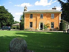
Built in 1837 on the site of an earlier manor house, the present Hall was constructed by John
Marriott who was a local farmer. It was bought by Annie Bayley in 1860 and has remained in the family ever since. The Hall was converted to a hotel in 1983.
567:
1157:
499:
Predominantly, most of the residents are clustered around the villages. Outside of these is a scattering of farms, farmhouses and cottages amongst a wider rural setting, with some industry.
1140:
319:
169:
128:
1150:
1172:
303:
732:
1177:
1162:
62:
379:
511:. The land varies from 25 metres (82 ft) in the Barnstone top right corner of the parish boundary to 38 metres (125 ft) in the south west area.
1228:
1167:
427:, England. The overall area had a population of 962 at the 2021 census, a drop from 980 of the 2011 census. The parish lies near the county border with
1118:
897:
654:
616:
327:
296:
265:
1182:
778:
Lamplugh, G. W. (George
William); Gibson, Walcot; Wedd, Charles Bertie; Sherlock, Robert Lionel; Smith, B.; Fox-Strangeways, Charles (1909).
478:
Langar is based in the western top of the parish. It is clustered around a square layout of roads, with a notable church and estate hall.
630:
A standout land feature, this was a former RAF base before being decommissioned and used for light civil aviation purposes to this day.
291:
603:
This was built 1855-1857 and was the successor of or nearby to an earlier medieval church. It was closed as a site of worship in 2017.
1202:
1197:
1192:
1145:
589:
371:
39:
361:
1207:
849:
308:
253:
205:
907:
598:
832:
890:
796:
575:
121:
1053:
682:
The parish has several areas catering to light to medium sized industry, some of which contain auxiliary buildings and
1080:
1187:
1085:
1033:
720:
1018:
366:
1008:
998:
993:
883:
436:
219:
1135:
988:
926:
473:
232:
784:. Cornell University Library. London, Printed for His Majesty's Stationery off., by Darling & son, ltd.
724:
284:
144:
527:. This accounts for several quarries and pits developed over the years located throughout the parish.
151:
814:
1233:
1048:
965:
950:
1090:
1038:
960:
955:
945:
753:
187:
111:
1023:
940:
493:
258:
1058:
913:
660:
508:
424:
177:
83:
1105:
875:
671:
428:
1222:
195:
416:
30:
639:
550:
566:
1064:
970:
779:
700:
664:
625:
524:
440:
420:
159:
542:
Rundle Beck, in the southern right corner of the parish, this flows into the:
394:
381:
1043:
694:
487:
243:
236:
1070:
1028:
1013:
668:
781:
The geology of the Melton
Mowbray district and southeast Nottinghamshire
1110:
1095:
1075:
1003:
850:"Listed Buildings in Langar cum Barnstone, Rushcliffe, Nottinghamshire"
211:
1100:
683:
432:
138:
615:
588:
565:
870:
520:
879:
341:
545:
River
Whipling, forming the north east corner of the boundary.
725:"2021 Census Area Profile – Langar cum Barnstone (E04007987)"
754:"Custom report - Nomis - Official Labour Market Statistics"
1128:
979:
933:
921:
336:
318:
302:
290:
278:
264:
252:
242:
228:
218:
204:
186:
168:
150:
136:
120:
109:
101:
93:
23:
797:"Church of St Andrew, Nottingham, Nottinghamshire"
553:which is beyond the north boundary of the parish.
674:at Barnstone, Langar Hall, and a war memorial.
891:
492:This is ½ mile north east of Langar. It is a
8:
69:
686:reused after the air base decommissioning:
507:The parish is very low-lying, being in the
898:
884:
876:
20:
1119:List of civil parishes in Nottinghamshire
620:British Parachute School, Langar Airfield
535:Three watercourses run through the area:
439:and 12 miles south east from the city of
655:Listed buildings in Langar cum Barnstone
456:The parish consists of two settlements:
712:
335:
317:
273:
241:
227:
203:
135:
119:
92:
48:
36:
871:Langar & Barnstone Parish Council
301:
289:
277:
263:
251:
217:
185:
167:
149:
108:
7:
663:, including the church dedicated to
97:6.28 sq mi (16.3 km)
819:southwellchurches.nottingham.ac.uk
14:
1229:Civil parishes in Nottinghamshire
584:
549:These all are tributaries of the
68:
61:
38:
693:Barnstone Works for processing
143:100 mi (160 km)
733:Office for National Statistics
561:
423:borough, within the county of
1:
659:Over 20 local structures are
431:. It lies 120 miles north of
1141:Parliamentary constituencies
854:britishlistedbuildings.co.uk
801:britishlistedbuildings.co.uk
539:Stroom Dyke, south of Langar
599:St Mary's Church, Barnstone
585:St Mary's Church, Barnstone
122:OS grid reference
1250:
1178:Grade II* listed buildings
652:
637:
623:
596:
576:St Andrew's Church, Langar
573:
570:St Andrew's Church, Langar
562:St Andrew's Church, Langar
523:, but principally is upon
485:
471:
352:
314:
274:
56:
49:
37:
28:
1173:Grade I listed buildings
690:Langar Industrial Estate
435:, 4 miles south east of
496:based along Main Road.
474:Langar, Nottinghamshire
18:Civil parish in England
667:at Langar, the former
621:
594:
571:
519:The area has some red
254:Postcode district
116:153/sq mi (59/km)
934:Boroughs or districts
833:"Langar Hall history"
815:"Barnstone - History"
619:
592:
569:
593:St Mary's, Barnstone
413:Langar cum Barnstone
220:Sovereign state
76:Langar cum Barnstone
24:Langar cum Barnstone
1183:Scheduled monuments
1106:West Bridgford
1049:Mansfield Woodhouse
982:(cities in italics)
966:Newark and Sherwood
922:Unitary authorities
391: /
1163:Places of interest
1091:Sutton-in-Ashfield
1039:Kirkby-in-Ashfield
758:www.nomisweb.co.uk
622:
595:
572:
320:UK Parliament
266:Dialling code
1216:
1215:
1024:Harworth Bircotes
980:Major settlements
908:Ceremonial county
494:linear settlement
410:
409:
170:Shire county
1241:
1203:Lord Lieutenants
916:
910:
900:
893:
886:
877:
858:
857:
846:
840:
839:
837:
829:
823:
822:
811:
805:
804:
792:
786:
785:
775:
769:
768:
766:
764:
750:
744:
743:
741:
739:
717:
649:Listed buildings
406:
405:
403:
402:
401:
396:
395:52.901°N 0.913°W
392:
389:
388:
387:
384:
358:
348:
345:
343:
214:
132:
131:
82:Location within
72:
71:
65:
42:
33:
21:
1249:
1248:
1244:
1243:
1242:
1240:
1239:
1238:
1219:
1218:
1217:
1212:
1124:
1113:
1059:Newark-on-Trent
981:
975:
929:
917:
914:Nottinghamshire
912:
906:
904:
867:
862:
861:
848:
847:
843:
835:
831:
830:
826:
813:
812:
808:
794:
793:
789:
777:
776:
772:
762:
760:
752:
751:
747:
737:
735:
719:
718:
714:
709:
680:
657:
651:
642:
636:
628:
614:
612:Langar airfield
609:
601:
587:
578:
564:
559:
557:Religious sites
533:
517:
509:Vale of Belvoir
505:
490:
484:
476:
470:
454:
449:
425:Nottinghamshire
399:
397:
393:
390:
385:
382:
380:
378:
377:
376:
372:Nottinghamshire
356:
342:langarbarnstone
340:
332:
297:Nottinghamshire
285:Nottinghamshire
210:
200:
182:
178:Nottinghamshire
164:
127:
126:
105:962 (2021)
89:
88:
87:
86:
84:Nottinghamshire
80:
79:
78:
77:
73:
52:
45:
29:
19:
12:
11:
5:
1247:
1245:
1237:
1236:
1231:
1221:
1220:
1214:
1213:
1211:
1210:
1205:
1200:
1195:
1190:
1185:
1180:
1175:
1170:
1168:Country houses
1165:
1160:
1155:
1154:
1153:
1143:
1138:
1132:
1130:
1126:
1125:
1123:
1122:
1108:
1103:
1098:
1093:
1088:
1083:
1078:
1073:
1068:
1061:
1056:
1051:
1046:
1041:
1036:
1031:
1026:
1021:
1016:
1011:
1006:
1001:
996:
991:
985:
983:
977:
976:
974:
973:
968:
963:
958:
953:
948:
943:
937:
935:
931:
930:
925:
923:
919:
918:
905:
903:
902:
895:
888:
880:
874:
873:
866:
865:External links
863:
860:
859:
841:
824:
806:
787:
770:
745:
711:
710:
708:
705:
704:
703:
698:
691:
679:
676:
672:chapel of ease
653:Main article:
650:
647:
638:Main article:
635:
632:
624:Main article:
613:
610:
608:
605:
597:Main article:
586:
583:
574:Main article:
563:
560:
558:
555:
547:
546:
543:
540:
532:
531:Water features
529:
525:lias limestone
516:
513:
504:
503:Land elevation
501:
486:Main article:
483:
480:
472:Main article:
469:
466:
465:
464:
461:
453:
450:
448:
445:
429:Leicestershire
408:
407:
400:52.901; -0.913
375:
374:
369:
364:
359:
357:List of places
353:
350:
349:
338:
334:
333:
331:
330:
324:
322:
316:
315:
312:
311:
306:
300:
299:
294:
288:
287:
282:
276:
275:
272:
271:
268:
262:
261:
256:
250:
249:
246:
240:
239:
230:
226:
225:
224:United Kingdom
222:
216:
215:
208:
202:
201:
199:
198:
192:
190:
184:
183:
181:
180:
174:
172:
166:
165:
163:
162:
156:
154:
148:
147:
141:
134:
133:
129:SK 73044 35078
124:
118:
117:
114:
107:
106:
103:
99:
98:
95:
91:
90:
81:
75:
74:
67:
66:
60:
59:
58:
57:
54:
53:
50:
47:
46:
43:
35:
34:
26:
25:
17:
13:
10:
9:
6:
4:
3:
2:
1246:
1235:
1232:
1230:
1227:
1226:
1224:
1209:
1208:High Sheriffs
1206:
1204:
1201:
1199:
1196:
1194:
1191:
1189:
1186:
1184:
1181:
1179:
1176:
1174:
1171:
1169:
1166:
1164:
1161:
1159:
1156:
1152:
1151:by population
1149:
1148:
1147:
1144:
1142:
1139:
1137:
1134:
1133:
1131:
1127:
1121:
1120:
1116:
1112:
1109:
1107:
1104:
1102:
1099:
1097:
1094:
1092:
1089:
1087:
1084:
1082:
1079:
1077:
1074:
1072:
1069:
1067:
1066:
1062:
1060:
1057:
1055:
1052:
1050:
1047:
1045:
1042:
1040:
1037:
1035:
1032:
1030:
1027:
1025:
1022:
1020:
1017:
1015:
1012:
1010:
1007:
1005:
1002:
1000:
997:
995:
992:
990:
987:
986:
984:
978:
972:
969:
967:
964:
962:
959:
957:
954:
952:
949:
947:
944:
942:
939:
938:
936:
932:
928:
924:
920:
915:
909:
901:
896:
894:
889:
887:
882:
881:
878:
872:
869:
868:
864:
855:
851:
845:
842:
834:
828:
825:
820:
816:
810:
807:
802:
798:
795:Stuff, Good.
791:
788:
783:
782:
774:
771:
759:
755:
749:
746:
734:
730:
726:
722:
716:
713:
706:
702:
699:
696:
692:
689:
688:
687:
685:
677:
675:
673:
670:
666:
662:
656:
648:
646:
641:
633:
631:
627:
618:
611:
606:
604:
600:
591:
582:
577:
568:
556:
554:
552:
544:
541:
538:
537:
536:
530:
528:
526:
522:
514:
512:
510:
502:
500:
497:
495:
489:
481:
479:
475:
467:
462:
459:
458:
457:
451:
446:
444:
442:
438:
434:
430:
426:
422:
418:
414:
404:
373:
370:
368:
365:
363:
360:
355:
354:
351:
347:
339:
329:
326:
325:
323:
321:
313:
310:
309:East Midlands
307:
305:
298:
295:
293:
286:
283:
281:
269:
267:
260:
257:
255:
247:
245:
238:
234:
231:
223:
221:
213:
209:
207:
197:
196:East Midlands
194:
193:
191:
189:
179:
176:
175:
173:
171:
161:
158:
157:
155:
153:
146:
142:
140:
130:
125:
123:
115:
113:
104:
100:
96:
85:
64:
55:
41:
32:
27:
22:
16:
1117:
1114:
1063:
853:
844:
827:
818:
809:
800:
790:
780:
773:
761:. Retrieved
757:
748:
736:. Retrieved
728:
715:
681:
658:
643:
629:
602:
579:
548:
534:
518:
506:
498:
491:
477:
455:
417:civil parish
412:
411:
31:Civil parish
15:
1054:Netherfield
763:14 November
640:Langar Hall
634:Langar Hall
551:River Smite
452:Settlements
398: /
44:Langar Hall
1234:Rushcliffe
1223:Categories
1081:Stapleford
1065:Nottingham
971:Rushcliffe
927:Nottingham
738:11 January
707:References
701:John Deere
665:St. Andrew
626:RAF Langar
441:Nottingham
421:Rushcliffe
383:52°54′04″N
328:Rushcliffe
248:NOTTINGHAM
160:Rushcliffe
102:Population
51:Parish map
1115:See also:
1086:Southwell
1044:Mansfield
1034:Kimberley
961:Mansfield
946:Bassetlaw
721:UK Census
607:Landmarks
488:Barnstone
482:Barnstone
463:Barnstone
447:Geography
386:0°54′47″W
304:Ambulance
244:Post town
237:Barnstone
1071:Ollerton
1029:Hucknall
1019:Eastwood
1014:Cotgrave
951:Broxtowe
941:Ashfield
723:(2021).
678:Industry
669:St. Mary
152:District
1198:Museums
1193:Schools
1188:History
1111:Worksop
1096:Tuxford
1076:Retford
1009:Carlton
1004:Bulwell
999:Bingham
994:Beeston
956:Gedling
697:/gypsum
684:hangars
515:Geology
437:Bingham
419:in the
367:England
337:Website
212:England
206:Country
137:•
112:Density
110:•
1146:Places
1129:Topics
1101:Warsop
989:Arnold
661:listed
468:Langar
460:Langar
433:London
280:Police
233:Langar
229:Places
188:Region
139:London
1158:SSSIs
836:(PDF)
729:Nomis
415:is a
270:01949
1136:Flag
765:2020
740:2024
695:lime
521:marl
292:Fire
259:NG13
94:Area
911:of
346:.uk
344:.co
1225::
852:.
817:.
799:.
756:.
731:.
727:.
443:.
362:UK
235:,
145:SE
899:e
892:t
885:v
856:.
838:.
821:.
803:.
767:.
742:.
Text is available under the Creative Commons Attribution-ShareAlike License. Additional terms may apply.