31:
50:
57:
416:. Inside the church is a four-sided font from the 12th century. The walls used to be covered in decorative paintings, one of them including a large painting of St Christopher. An organisation under the name 'Friends of Thurton Church' continue to help raise money for future restorations and the ongoing maintenance of the church.
240:
467:
Shrubb is listed on the
Diggers and Dreamers online directory, and there is a video of the early days at Shrubb on YouTube titled 'Shrubb Family 1973 part 1 & 2'. Shrubb is featured in "Communes in Britain" by Andrew Rigby, 1974. As of recent years the membership of the group has fluctuated and
464:
communities in
England. Founded in 1970 in a 17th-century cottage near the old A11 and the Angel pub, the membership and fortunes of the community have fluctuated over the years, but the ethos of low-impact living and environmental harmony has
404:, with a tower later being added in the 16th century. The church is built of flint, with stone used only for dressings. The tower is in the 15th-century Perpendicular style. On the north side there is a staircase turret that leads to the
144:
264:
88:
772:
226:
386:
702:
508:
490:
252:
655:
591:
269:
747:
306:
524:
288:
257:
214:
180:
35:
49:
445:
81:
767:
441:
777:
752:
298:
293:
378:
The village’s name means 'Lyrel's people'. Earlier spellings include
Lurling, Lirling, Lerling, or Lerlingford.
449:
425:
194:
563:
668:
400:
The still-standing medieval church was built in the 12th century, and was expanded in the 1340s creating the
719:
461:
405:
245:
134:
126:
586:
The
Domesday Book, Englands Heritage, Then and Now, Editor: Thomas Hinde,Norfolk page 191, Larling,
30:
650:
The King’s
England series, NORFOLK, by Arthur Mee,Pub:Hodder and Stoughton,1972, page 154 Larling,
409:
347:
116:
385:
of 1086. In the great book
Larling is recorded by the name ‘’Lur(i)inga’’. The main landholder is
559:
351:
162:
698:
651:
587:
504:
486:
695:
Diggers and dreamers : the 1990/91 guide to communal living, edited by Vera Ansell et al
520:
219:
170:
545:
429:
625:
761:
382:
343:
108:
603:
321:
308:
433:
413:
204:
444:
station offers two trains a day in each direction. The nearest airport is
359:
437:
401:
363:
355:
186:
152:
70:
408:. The windows date from the 15th century also. There is an ornamented
367:
98:
485:
OS Explorer Map 236 - King’s Lynn, Downham Market & Swaffham.
392:
On 1 April 1935 the parish was abolished and merged with
Roudham.
389:
with the main tenant being Hugh. The survey also mentions a mill.
565:
An Essay
Towards a Topographical History of the County of Norfolk
697:. Dunford Bridge, Sheffield, : Communes Network. 1989.
358:, England. The village is 8.5 miles east north east of
604:"Relationships and changes Larling AP/CP through time"
424:
The nearest railway station with a full service is at
503:
County A to Z Atlas, Street & Road maps
Norfolk,
263:
251:
239:
225:
213:
203:
193:
179:
161:
143:
125:
107:
96:
80:
23:
724:Diggers and Dreamers: the guide to communal living
521:"Population statistics Larling AP/CP through time"
448:. The village is situated a little north of the
370:. In 1931 the parish had a population of 159.
8:
460:Shrubb family is one of the longest-running
412:doorway, with one of the pillars carrying a
20:
477:
234:
202:
178:
95:
79:
27:
568:. London: William Miller. p. 428
468:has been left with around 6 members.
262:
250:
238:
224:
212:
192:
160:
142:
124:
7:
396:The Parish Church of Saint Ethelbert
606:. A Vision of Britain through Time
14:
773:Former civil parishes in Norfolk
525:A Vision of Britain through Time
362:, 21.4 miles west south west of
55:
48:
29:
56:
1:
446:Norwich International Airport
632:. Archbishops' Council. 2016
546:"Key to English Place-names"
381:Larling has an entry in the
366:and 94 miles north east of
354:district, in the county of
82:OS grid reference
18:Human settlement in England
794:
279:
275:
235:
43:
38:’s Parish Church, Larling
28:
342:is a village and former
673:www.greateranglia.co.uk
667:Greater Anglia Trains.
626:"The Church of England"
346:, now in the parish of
748:Larling Church Website
720:"Diggers and Dreamers"
215:Postcode district
103:94 miles (151 km)
630:The Church of England
322:52.4695°N 0.916897°E
195:Sovereign state
768:Villages in Norfolk
560:Blomefield, Francis
432:which runs between
348:Roudham and Larling
318: /
117:Roudham and Larling
778:Breckland District
387:William de Warenne
227:Dialling code
704:978-0-9514945-0-9
509:978-1-84348-614-5
491:978-0-319-46408-3
337:
336:
327:52.4695; 0.916897
145:Shire county
785:
735:
734:
732:
730:
715:
709:
708:
691:
685:
684:
682:
680:
675:. Greater Anglia
664:
658:
648:
642:
641:
639:
637:
622:
616:
615:
613:
611:
600:
594:
584:
578:
577:
575:
573:
556:
550:
549:
542:
536:
535:
533:
531:
517:
511:
501:
495:
482:
333:
332:
330:
329:
328:
323:
319:
316:
315:
314:
311:
285:
189:
92:
91:
69:Location within
59:
58:
52:
33:
21:
793:
792:
788:
787:
786:
784:
783:
782:
758:
757:
744:
739:
738:
728:
726:
717:
716:
712:
705:
693:
692:
688:
678:
676:
666:
665:
661:
649:
645:
635:
633:
624:
623:
619:
609:
607:
602:
601:
597:
585:
581:
571:
569:
558:
557:
553:
544:
543:
539:
529:
527:
519:
518:
514:
502:
498:
483:
479:
474:
466:
458:
422:
398:
376:
326:
324:
320:
317:
312:
309:
307:
305:
304:
303:
283:
270:East of England
185:
175:
157:
139:
121:
87:
86:
76:
75:
74:
73:
67:
66:
65:
64:
60:
39:
19:
12:
11:
5:
791:
789:
781:
780:
775:
770:
760:
759:
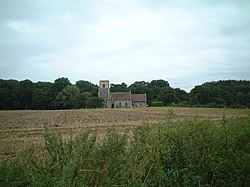
756:
755:
750:
743:
742:External links
740:
737:
736:
718:Ansell, Vera.
710:
703:
686:
669:"Harling Road"
659:
643:
617:
595:
579:
551:
537:
512:
496:
476:
475:
473:
470:
457:
454:
430:Breckland Line
421:
418:
397:
394:
375:
372:
335:
334:
302:
301:
296:
291:
286:
284:List of places
280:
277:
276:
273:
272:
267:
261:
260:
255:
249:
248:
243:
237:
236:
233:
232:
229:
223:
222:
217:
211:
210:
207:
201:
200:
199:United Kingdom
197:
191:
190:
183:
177:
176:
174:
173:
167:
165:
159:
158:
156:
155:
149:
147:
141:
140:
138:
137:
131:
129:
123:
122:
120:
119:
113:
111:
105:
104:
101:
94:
93:
84:
78:
77:
68:
62:
61:
54:
53:
47:
46:
45:
44:
41:
40:
34:
26:
25:
17:
13:
10:
9:
6:
4:
3:
2:
790:
779:
776:
774:
771:
769:
766:
765:
763:
754:
753:Shrubb Family
751:
749:
746:
745:
741:
725:
721:
714:
711:
706:
700:
696:
690:
687:
674:
670:
663:
660:
657:
656:0-340-15061-0
653:
647:
644:
631:
627:
621:
618:
605:
599:
596:
593:
592:1-85833-440-3
589:
583:
580:
567:
566:
561:
555:
552:
547:
541:
538:
526:
522:
516:
513:
510:
506:
500:
497:
494:
492:
488:
481:
478:
471:
469:
463:
456:Shrubb Family
455:
453:
451:
447:
443:
439:
435:
431:
427:
419:
417:
415:
411:
407:
403:
395:
393:
390:
388:
384:
383:Domesday Book
379:
373:
371:
369:
365:
361:
357:
353:
349:
345:
341:
331:
300:
297:
295:
292:
290:
287:
282:
281:
278:
274:
271:
268:
266:
259:
256:
254:
247:
244:
242:
230:
228:
221:
218:
216:
208:
206:
198:
196:
188:
184:
182:
172:
169:
168:
166:
164:
154:
151:
150:
148:
146:
136:
133:
132:
130:
128:
118:
115:
114:
112:
110:
106:
102:
100:
90:
85:
83:
72:
51:
42:
37:
32:
22:
16:
727:. Retrieved
723:
713:
694:
689:
677:. Retrieved
672:
662:
646:
634:. Retrieved
629:
620:
608:. Retrieved
598:
582:
570:. Retrieved
564:
554:
540:
528:. Retrieved
515:
499:
484:
480:
459:
452:Trunk road.
442:Harling Road
423:
399:
391:
380:
377:
344:civil parish
339:
338:
109:Civil parish
36:St Ethelbert
15:
679:16 December
572:16 December
325: /
762:Categories
530:25 January
472:References
465:persisted.
310:52°28′10″N
610:28 August
434:Cambridge
420:Transport
414:mass dial
352:Breckland
350:, in the
313:0°55′01″E
265:Ambulance
205:Post town
135:Breckland
729:24 April
636:24 April
562:(1805).
462:communal
428:for the
426:Thetford
360:Thetford
127:District
438:Norwich
402:chancel
374:History
364:Norwich
356:Norfolk
340:Larling
299:Norfolk
294:England
258:Norfolk
246:Norfolk
209:NORWICH
187:England
181:Country
153:Norfolk
97:•
71:Norfolk
63:Larling
24:Larling
701:
654:
590:
507:
489:
440:, but
410:Norman
406:belfry
368:London
241:Police
163:Region
99:London
89:TL9889
231:01953
731:2016
699:ISBN
681:2021
652:ISBN
638:2016
612:2022
588:ISBN
574:2021
532:2022
505:ISBN
487:ISBN
436:and
253:Fire
220:NR16
171:East
450:A11
764::
722:.
671:.
628:.
523:.
289:UK
733:.
707:.
683:.
640:.
614:.
576:.
548:.
534:.
493:.
Text is available under the Creative Commons Attribution-ShareAlike License. Additional terms may apply.