64:
418:
97:
50:
104:
71:
38:
323:
The highest point on the island is
Leinehornet which is 363 metres (1,191 ft) above sea level. The island has an area of 14.4 square kilometres (5.6 sq mi). The village of
459:
63:
493:
452:
478:
483:
445:
153:
498:
96:
277:
252:
340:
387:
317:
297:
488:
417:
425:
281:
242:
137:
392:
309:
301:
300:. The island is connected to several surrounding islands via a network of bridges. The
429:
49:
472:
292:, but Leinøya is now the official name. The island is located east of the town of
328:
313:
293:
360:
168:
155:
305:
17:
324:
285:
141:
37:
382:
316:(to the south), and a small bridge connects to the island of
433:
327:, on the east side of the island, is a stop on the
263:
258:
248:
238:
224:
216:
208:
200:
192:
184:
147:
133:
128:
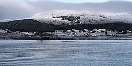
42:View of Torvik on the east coast of the island.
453:
8:
30:
331:. In 2015, the island had 1,479 residents.
460:
446:
48:
36:
29:
352:
361:"Stadnamn og skrivemåten for stadnamn"
7:
414:
412:
276:is an island in the municipality of
381:Thorsnæs, Geir, ed. (2015-09-12).
188:14.4 km (5.6 sq mi)
25:
424:This article about an island in
416:
102:
95:
69:
62:
494:Møre og Romsdal geography stubs
103:
70:
1:
432:. You can help Knowledge by
312:connects it to Nautøya and
86:Show map of Møre og Romsdal
515:
479:Islands of Møre og Romsdal
411:
363:(in Norwegian). Kartverket
304:connects it to the island
341:List of islands of Norway
229:
212:364 m (1194 ft)
56:
47:
35:
296:on the nearby island of
288:. Its original name was
204:4 km (2.5 mi)
196:5 km (3.1 mi)
484:Herøy, Møre og Romsdal
209:Highest elevation
83:Location of the island
388:Store norske leksikon
308:(to the north), the
499:Norway island stubs
165: /
32:
253:Herøy Municipality
217:Highest point
169:62.3380°N 5.7015°E
119:Show map of Norway
441:
440:
393:Kunnskapsforlaget
271:
270:
16:(Redirected from
506:
462:
455:
448:
420:
413:
403:
402:
400:
399:
391:(in Norwegian).
378:
372:
371:
369:
368:
357:
180:
179:
177:
176:
175:
170:
166:
163:
162:
161:
158:
120:
116:Leinøya (Norway)
106:
105:
99:
87:
73:
72:
66:
52:
40:
33:
27:Island in Norway
21:
514:
513:
509:
508:
507:
505:
504:
503:
469:
468:
467:
466:
426:Møre og Romsdal
409:
407:
406:
397:
395:
380:
379:
375:
366:
364:
359:
358:
354:
349:
337:
320:(to the west).
282:Møre og Romsdal
243:Møre og Romsdal
234:
174:62.3380; 5.7015
173:
171:
167:
164:
159:
156:
154:
152:
151:
138:Møre og Romsdal
124:
123:
122:
121:
118:
117:
114:
113:
112:
111:
107:
90:
89:
88:
85:
84:
81:
80:
79:
78:
74:
43:
28:
23:
22:
15:
12:
11:
5:
512:
510:
502:
501:
496:
491:
486:
481:
471:
470:
465:
464:
457:
450:
442:
439:
438:
421:
405:
404:
373:
351:
350:
348:
345:
344:
343:
336:
333:
269:
268:
265:
261:
260:
256:
255:
250:
246:
245:
240:
236:
235:
230:
227:
226:
225:Administration
222:
221:
218:
214:
213:
210:
206:
205:
202:
198:
197:
194:
190:
189:
186:
182:
181:
149:
145:
144:
135:
131:
130:
126:
125:
115:
109:
108:
101:
100:
94:
93:
92:
91:
82:
76:
75:
68:
67:
61:
60:
59:
58:
57:
54:
53:
45:
44:
41:
26:
24:
14:
13:
10:
9:
6:
4:
3:
2:
511:
500:
497:
495:
492:
490:
487:
485:
482:
480:
477:
476:
474:
463:
458:
456:
451:
449:
444:
443:
437:
435:
431:
427:
422:
419:
415:
410:
394:
390:
389:
384:
377:
374:
362:
356:
353:
346:
342:
339:
338:
334:
332:
330:
326:
321:
319:
315:
311:
307:
303:
299:
295:
291:
287:
283:
279:
275:
266:
262:
257:
254:
251:
247:
244:
241:
237:
233:
228:
223:
219:
215:
211:
207:
203:
199:
195:
191:
187:
183:
178:
150:
146:
143:
139:
136:
132:
127:
98:
65:
55:
51:
46:
39:
34:
19:
434:expanding it
423:
408:
396:. Retrieved
386:
376:
365:. Retrieved
355:
322:
310:Herøy Bridge
302:Remøy Bridge
289:
273:
272:
259:Demographics
249:Municipality
231:
329:Hurtigruten
267:1479 (2015)
220:Leinehornet
172: /
148:Coordinates
473:Categories
398:2019-09-08
367:2019-09-08
347:References
264:Population
157:62°20′17″N
383:"Leinøya"
160:5°42′05″E
129:Geography
489:Sunnmøre
335:See also
318:Bergsøya
314:Gurskøya
298:Bergsøya
294:Fosnavåg
290:Bølandet
284:county,
134:Location
274:Leinøya
110:Leinøya
77:Leinøya
31:Leinøya
325:Torvik
306:Remøya
286:Norway
239:County
232:Norway
193:Length
142:Norway
18:Leinøy
428:is a
278:Herøy
201:Width
430:stub
185:Area
280:in
475::
385:.
140:,
461:e
454:t
447:v
436:.
401:.
370:.
20:)
Text is available under the Creative Commons Attribution-ShareAlike License. Additional terms may apply.