53:
347:
27:
86:
39:
93:
60:
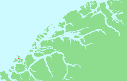
281:(to the north). The highest point on the island is Vardan which is 191 metres (627 ft) above sea level. Virtually all of the island's residents live on the southern portion of the island in the 0.41-square-kilometre (100-acre) village area called Remøy. The island had a population of 330 in 2015.
388:
52:
422:
381:
407:
412:
374:
142:
427:
250:
225:
85:
265:. The 3.6-square-kilometre (1.4 sq mi) island is connected to other islands via a network of bridges. The
290:
316:
417:
346:
354:
254:
215:
126:
321:
26:
266:
358:
401:
38:
274:
262:
157:
144:
270:
258:
130:
278:
311:
261:. The island is located north of the municipal center of
362:
236:
231:
221:
211:
197:
189:
181:
173:
136:
122:
117:
382:
8:
19:
389:
375:
37:
25:
18:
16:Island in Herøy, Møre og Romsdal, Norway
302:
7:
343:
341:
249:is an island in the municipality of
310:Thorsnæs, Geir, ed. (2015-09-12).
14:
177:3.6 km (1.4 sq mi)
353:This article about an island in
345:
91:
84:
58:
51:
423:Møre og Romsdal geography stubs
92:
59:
1:
361:. You can help Knowledge by
75:Show map of Møre og Romsdal
444:
408:Islands of Møre og Romsdal
340:
269:connects it to the island
291:List of islands of Norway
202:
45:
36:
24:
185:191 m (627 ft)
273:(to the south) and the
413:Herøy, Møre og Romsdal
182:Highest elevation
72:Location of the island
317:Store norske leksikon
428:Norway island stubs
154: /
21:
226:Herøy Municipality
190:Highest point
158:62.3683°N 5.6397°E
108:Show map of Norway
31:View of the island
370:
369:
322:Kunnskapsforlaget
244:
243:
435:
391:
384:
377:
349:
342:
332:
331:
329:
328:
320:(in Norwegian).
307:
169:
168:
166:
165:
164:
159:
155:
152:
151:
150:
147:
109:
95:
94:
88:
76:
62:
61:
55:
41:
29:
22:
443:
442:
438:
437:
436:
434:
433:
432:
398:
397:
396:
395:
355:Møre og Romsdal
338:
336:
335:
326:
324:
309:
308:
304:
299:
287:
277:connects it to
255:Møre og Romsdal
216:Møre og Romsdal
207:
163:62.3683; 5.6397
162:
160:
156:
153:
148:
145:
143:
141:
140:
127:Møre og Romsdal
113:
112:
111:
110:
107:
106:
105:Remøya (Norway)
103:
102:
101:
100:
96:
79:
78:
77:
74:
73:
70:
69:
68:
67:
63:
32:
17:
12:
11:
5:
441:
439:
431:
430:
425:
420:
415:
410:
400:
399:
394:
393:
386:
379:
371:
368:
367:
350:
334:
333:
301:
300:
298:
295:
294:
293:
286:
283:
242:
241:
238:
234:
233:
229:
228:
223:
219:
218:
213:
209:
208:
203:
200:
199:
198:Administration
195:
194:
191:
187:
186:
183:
179:
178:
175:
171:
170:
138:
134:
133:
124:
120:
119:
115:
114:
104:
98:
97:
90:
89:
83:
82:
81:
80:
71:
65:
64:
57:
56:
50:
49:
48:
47:
46:
43:
42:
34:
33:
30:
15:
13:
10:
9:
6:
4:
3:
2:
440:
429:
426:
424:
421:
419:
416:
414:
411:
409:
406:
405:
403:
392:
387:
385:
380:
378:
373:
372:
366:
364:
360:
356:
351:
348:
344:
339:
323:
319:
318:
313:
306:
303:
296:
292:
289:
288:
284:
282:
280:
276:
272:
268:
264:
260:
256:
252:
248:
239:
235:
230:
227:
224:
220:
217:
214:
210:
206:
201:
196:
192:
188:
184:
180:
176:
172:
167:
139:
135:
132:
128:
125:
121:
116:
87:
54:
44:
40:
35:
28:
23:
363:expanding it
352:
337:
325:. Retrieved
315:
305:
275:Runde Bridge
267:Remøy Bridge
246:
245:
232:Demographics
222:Municipality
204:
161: /
137:Coordinates
402:Categories
327:2019-09-08
297:References
240:330 (2015)
237:Population
146:62°22′06″N
149:5°38′23″E
118:Geography
418:Sunnmøre
312:"Remøya"
285:See also
263:Fosnavåg
257:county,
123:Location
271:Leinøya
259:Norway
247:Remøya
212:County
205:Norway
193:Vardan
131:Norway
99:Remøya
66:Remøya
20:Remøya
357:is a
279:Runde
251:Herøy
359:stub
174:Area
253:in
404::
314:.
129:,
390:e
383:t
376:v
365:.
330:.
Text is available under the Creative Commons Attribution-ShareAlike License. Additional terms may apply.
↑