142:
681:
26:
158:
150:
394:
In the
Leogang Mountains there are only two mountain huts. They belong to the DAV - Deutscher Alpenverein - German Alpine Club but are operated by local Austrians. The DAV operates a Recripical Rights system so that OEVA - Austrian Alpine Club member discounts, were applicable, can be enjoyed.
213:(1,202 m), but which the Alpine categorisation of the Eastern Alps defines as a single sub-group (the Lofer and Leogang Mountains). The Leogang Mountains are separated from the
715:
720:
509:
424:, open in summer from mid-June to end of September, 45 mattress bunks, winter accommodation with 6 bedspaces, Valley destinations: Leogang, walking time: 2.75 hours.
94:
700:
502:
473:
705:
221:
to the east by deeply incised valleys. Typical of the
Steinberge are high plateaux with steep sides and sharply undulating high cirques.
141:
710:
495:
680:
87:
555:
640:
519:
186:
133:
625:
595:
262:
182:
76:
630:
580:
635:
565:
289:
416:
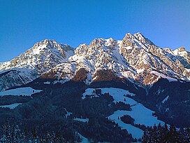
545:
487:
283:
80:
444:
435:
469:
295:
214:
645:
620:
585:
550:
540:
301:
443:, open in summer, no winter accommodation, no bedspaces, Valley destinations: Pernerwinkel-
610:
575:
277:
218:
206:
170:
655:
447:(2h walk), Wiesersberg-Gerstboden (2.5h walk), Leogang (2h walk), Mitterbrand (1.5h walk)
408:
237:
530:
233:
126:
694:
650:
615:
560:
535:
261:
is the highest peak in the range. The
Hochfilzen Military Training Area used by the
209:
to the northwest, form two mountain massifs that are separated by the saddle of the
25:
670:
665:
600:
570:
190:
406:, only opened during the day in summer and winter, 6 mattress bunks, next to the
660:
245:
198:
109:
96:
590:
273:
The
Leogang Mountains border on the following mountain groups in the Alps:
157:
314:
257:
41:
202:
178:
149:
66:
48:
241:
225:
194:
156:
148:
140:
229:
491:
228:
mountains the
Leogang Mountains are also pierced by numerous
177:, lit. "Leogang Rock Mountains") are a mountain range in
236:, over 50 km long, located immediately next to the
252:in the southeastern face of the Birnhorn mountain.
125:
86:
72:
62:
57:
47:
37:
32:
18:
265:lies in the west of the Leoganger Steinberge.
503:
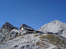
161:View from the Passauer Hut of the Fahnenköpfl
8:
145:The Passauer Hut and Birnhorn in late autumn
716:Mountain ranges of Salzburg (federal state)
510:
496:
488:
15:
721:Mountain ranges of Tyrol (federal state)
468:, Austrian Academy of Sciences, p. 173.
457:
441:1,441 m above sea level (AA)
422:2,033 m above sea level (AA)
379:2,099 m above sea level (AA)
373:2,142 m above sea level (AA)
367:2,206 m above sea level (AA)
361:2,243 m above sea level (AA)
355:2,280 m above sea level (AA)
349:2,442 m above sea level (AA)
343:2,462 m above sea level (AA)
337:2,467 m above sea level (AA)
331:2,465 m above sea level (AA)
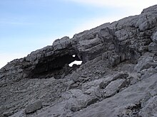
325:2,500 m above sea level (AA)
319:2,634 m above sea level (AA)
7:
404:664 m above sea level (AA)
255:At 2,634 metres (8,642 ft) the
248:. A prominent rock formation is the
232:. The most famous of these is the
14:
464:Lichtenberger, Elisabeth (2000).
701:Loferer and Leoganger Steinberge
679:
24:
400:Lamprechtsofen-Höhlengaststätte
193:. They are located between the
1:
466:Austria: society and regions
153:Melkerloch from the Hochgrub
53:2,634 m (8,642 ft)
706:Mountain ranges of the Alps
737:
677:
526:
23:
412:from Lofer to Saalfelden
711:Northern Limestone Alps
520:Northern Limestone Alps
518:Mountain ranges of the
205:and, together with the
187:Northern Limestone Alps
134:Northern Limestone Alps
626:Upper Austrian Prealps
174:
162:
154:
146:
335:Grießener Hochbrett:
217:to the south and the
185:and form part of the
160:
152:
144:
110:47.47472°N 12.73361°E
631:Rax-Schneeberg Group
175:Leoganger Steinberge
636:Salzburg Slate Alps
290:Salzburg Slate Alps
269:Neighbouring ranges
106: /
546:Berchtesgaden Alps
284:Berchtesgaden Alps
163:
155:
147:
115:47.47472; 12.73361
33:Highest point
688:
687:
474:978-3-7001-2775-8
167:Leogang Mountains
139:
138:
88:Range coordinates
19:Leogang Mountains
728:
683:
551:Brandenberg Alps
541:Bavarian Prealps
512:
505:
498:
489:
477:
462:
442:
423:
405:
390:Alpine Club huts
380:
374:
368:
362:
356:
350:
347:Großes Rothorn:
344:
338:
332:
326:
320:
302:Kaiser Mountains
292:to the southeast
280:to the northwest
181:in the state of
129:
121:
120:
118:
117:
116:
111:
107:
104:
103:
102:
99:
28:
16:
736:
735:
731:
730:
729:
727:
726:
725:
691:
690:
689:
684:
675:
576:Gutenstein Alps
522:
516:
486:
481:
480:
463:
459:
454:
440:
431:
421:
403:
392:
387:
378:
372:
366:
360:
354:
348:
342:
336:
330:
324:
318:
311:
278:Lofer Mountains
271:
219:Steinernes Meer
207:Lofer Mountains
127:
114:
112:
108:
105:
100:
97:
95:
93:
92:
12:
11:
5:
734:
732:
724:
723:
718:
713:
708:
703:
693:
692:
686:
685:
678:
676:
674:
673:
668:
663:
658:
653:
648:
643:
638:
633:
628:
623:
618:
613:
608:
603:
598:
593:
588:
583:
578:
573:
568:
563:
558:
556:Bregenz Forest
553:
548:
543:
538:
533:
527:
524:
523:
517:
515:
514:
507:
500:
492:
485:
484:External links
482:
479:
478:
456:
455:
453:
450:
449:
448:
430:
427:
426:
425:
413:
391:
388:
386:
383:
382:
381:
375:
369:
363:
357:
351:
345:
339:
333:
329:Passauerkopf:
327:
321:
310:
307:
306:
305:
299:
296:Kitzbühel Alps
293:
287:
281:
270:
267:
234:Lamprechtsofen
215:Kitzbühel Alps
137:
136:
131:
123:
122:
90:
84:
83:
74:
70:
69:
64:
60:
59:
55:
54:
51:
45:
44:
39:
35:
34:
30:
29:
21:
20:
13:
10:
9:
6:
4:
3:
2:
733:
722:
719:
717:
714:
712:
709:
707:
704:
702:
699:
698:
696:
682:
672:
669:
667:
664:
662:
659:
657:
654:
652:
651:Totes Gebirge
649:
647:
644:
642:
641:Salzkammergut
639:
637:
634:
632:
629:
627:
624:
622:
621:Mürzsteg Alps
619:
617:
616:Mieming Range
614:
612:
609:
607:
604:
602:
599:
597:
594:
592:
589:
587:
584:
582:
579:
577:
574:
572:
569:
567:
564:
562:
561:Chiemgau Alps
559:
557:
554:
552:
549:
547:
544:
542:
539:
537:
536:Ammergau Alps
534:
532:
529:
528:
525:
521:
513:
508:
506:
501:
499:
494:
493:
490:
483:
475:
471:
467:
461:
458:
451:
446:
438:
437:
433:
432:
429:Mountain huts
428:
419:
418:
414:
411:
410:
401:
398:
397:
396:
389:
384:
376:
371:Fahnenköpfl:
370:
364:
358:
353:Dürrkarhorn:
352:
346:
340:
334:
328:
322:
316:
313:
312:
308:
303:
300:
297:
294:
291:
288:
285:
282:
279:
276:
275:
274:
268:
266:
264:
263:Austrian Army
260:
259:
253:
251:
247:
243:
239:
235:
231:
227:
222:
220:
216:
212:
208:
204:
200:
196:
192:
188:
184:
180:
176:
172:
168:
159:
151:
143:
135:
132:
130:
124:
119:
91:
89:
85:
82:
78:
75:
71:
68:
65:
61:
56:
52:
50:
46:
43:
40:
36:
31:
27:
22:
17:
671:Ybbstal Alps
666:Vienna Woods
656:Türnitz Alps
605:
601:Lechtal Alps
571:Ennstal Alps
465:
460:
434:
417:Passauer Hut
415:
409:Bundesstraße
407:
399:
393:
365:Mitterhorn:
341:Signalkopf:
323:Kuchelhorn:
298:to the south
272:
256:
254:
249:
238:federal road
223:
210:
191:Eastern Alps
166:
164:
128:Parent range
661:Wetterstein
596:Lechquellen
531:Allgäu Alps
377:Brandhorn:
304:to the west
286:to the east
224:As typical
211:Römersattel
189:within the
113: /
695:Categories
581:Hochschwab
452:References
445:Gerstboden
439:: height:
436:Lettlkaser
420:: Height:
402:: Height:
359:Hochzint:
250:Melkerloch
246:Saalfelden
199:Saalfelden
98:47°28′29″N
591:Karwendel
566:Dachstein
101:12°44′1″E
58:Geography
49:Elevation
315:Birnhorn
258:Birnhorn
240:between
197:valley,
183:Salzburg
77:Salzburg
42:Birnhorn
606:Leogang
385:Tourism
203:Leogang
179:Austria
67:Austria
63:Country
646:Tennen
586:Kaiser
472:
171:German
73:States
611:Lofer
309:Peaks
242:Lofer
230:caves
226:karst
195:Lofer
81:Tyrol
470:ISBN
244:and
201:and
165:The
79:and
38:Peak
697::
317::
173::
511:e
504:t
497:v
476:.
169:(
Text is available under the Creative Commons Attribution-ShareAlike License. Additional terms may apply.