167:
135:
123:
105:
153:
27:
186:
93:
in
Antarctica; not only is it scenic, but the protected waters are usually as still as a lake, a rare occurrence in the storm-wracked southern seas, and the north-south traverse delivers vessels close to
98:
for landings. The principal difficulty is that icebergs may fill the channel, especially in early season, obliging a ship to backtrack and go around the outside of Booth Island to reach
Petermann.
122:
104:
134:
166:
371:
189:
322:
361:
65:-filled passage, which is 11 km (6.8 mi) long and just 600 metres (2,000 ft) wide at its narrowest point.
75:
83:
19:
This article is about the sea passage off
Antarctica. For the passage along Tierra del Fuego (South America), see
201:
280:
142:
366:
68:
It was first seen by the German expedition of 1873-74, but not traversed until
December 1898, when the
228:
223:
90:
79:
218:
284:
244:
240:
152:
70:
95:
20:
296:
256:
46:
355:
260:
276:
252:
248:
111:
54:
268:
50:
213:
26:
272:
128:
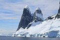
Glaciers and cliffs reflected in still waters at the south end of the channel.
42:
337:
324:
239:
Features of the southeast coast of the channel include, from north to south,
301:
264:
158:
110:
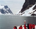
In the north entry of
Lemaire Channel looking south, from the deck of the
313:
62:
58:
38:
185:
89:
The channel has since become a standard part of the itinerary for
25:
30:
Location of Kyiv
Peninsula in Graham Land, Antarctic Peninsula.
57:. Nicknamed "Kodak Gap" by some, it is one of the top
61:
destinations in
Antarctica; steep cliffs hem in the
86:(1863-1925), a Belgian explorer of the Congo.
8:
100:
314:SCAR Composite Gazetteer of Antarctica
7:
78:passed through. Expedition leader
14:
190:Copernix annotated satellite view
184:
165:
151:
133:
121:
103:
1:
76:Belgian Antarctic Expedition
372:Tourism sites in Antarctica
229:GPX (secondary coordinates)
388:
18:
224:GPX (primary coordinates)
199:Map all coordinates using
281:Mount Scott (Antarctica)
207:Download coordinates as:
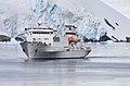
172:Icebergs in the channel
143:Akademik Sergey Vavilov
146:in the Lemaire Channel
31:
362:Straits of Antarctica
219:GPX (all coordinates)
29:
140:Russian cruise ship
16:Strait in Antarctica
334: /
80:Adrien de Gerlache
49:in the mainland's
32:
338:65.133°S 64.000°W
285:Duseberg Buttress
245:Humphries Heights
241:False Cape Renard
379:
349:
348:
346:
345:
344:
343:-65.133; -64.000
339:
335:
332:
331:
330:
327:
188:
169:
155:
137:
125:
107:
96:Petermann Island
387:
386:
382:
381:
380:
378:
377:
376:
352:
351:
342:
340:
336:
333:
328:
325:
323:
321:
320:
310:
293:
237:
236:
235:
234:
233:
194:
193:
192:
180:
173:
170:
161:
156:
147:
138:
129:
126:
117:
108:
84:Charles Lemaire
35:Lemaire Channel
24:
21:Le Maire Strait
17:
12:
11:
5:
385:
383:
375:
374:
369:
364:
354:
353:
318:
317:
309:
306:
305:
304:
299:
297:Nimrod Passage
292:
289:
257:Hotine Glacier
232:
231:
226:
221:
216:
210:
204:
197:
196:
195:
183:
182:
181:
179:
176:
175:
174:
171:
164:
162:
157:
150:
148:
139:
132:
130:
127:
120:
118:
109:
102:
47:Kyiv Peninsula
15:
13:
10:
9:
6:
4:
3:
2:
384:
373:
370:
368:
365:
363:
360:
359:
357:
350:
347:
315:
312:
311:
307:
303:
300:
298:
295:
294:
290:
288:
286:
282:
278:
274:
270:
266:
262:
261:Glandaz Point
258:
254:
250:
246:
242:
230:
227:
225:
222:
220:
217:
215:
212:
211:
209:
208:
203:
202:OpenStreetMap
200:
191:
187:
177:
168:
163:
160:
154:
149:
145:
144:
136:
131:
124:
119:
116:
114:
106:
101:
99:
97:
92:
87:
85:
82:named it for
81:
77:
73:
72:
66:
64:
60:
56:
52:
48:
44:
40:
36:
28:
22:
367:Graham Coast
319:
277:Leay Glacier
253:Deloncle Bay
249:Loubat Point
238:
206:
205:
198:
141:
112:
88:
69:
67:
55:Booth Island
34:
33:
341: /
269:Mount Cloos
51:Graham Land
356:Categories
329:64°00′00″W
326:65°07′59″S
308:References
273:Cape Cloos
45:, between
43:Antarctica
302:Una Peaks
265:Una Peaks
159:Una Peaks
113:Hanseatic
291:See also
178:Features
91:cruising
74:of the
71:Belgica
63:iceberg
59:tourist
39:strait
37:is a
53:and
41:off
214:KML
358::
287:.
283:,
279:,
275:,
271:,
267:,
263:,
259:,
255:,
251:,
247:,
243:,
316:.
115:.
23:.
Text is available under the Creative Commons Attribution-ShareAlike License. Additional terms may apply.