632:
224:
533:
325:
100:, which inherited this role from the Scottish Development Department in 1991. Once listed, severe restrictions are imposed on the modifications allowed to a building's structure or its fittings. Listed building consent must be obtained from local authorities prior to any alteration to such a structure. There are approximately 47,000 listed buildings in Scotland, of which around 8 percent (some 3,800) are Category A.
427:
772:
87:
In
Scotland, the term listed building refers to a building or other structure officially designated as being of "special architectural or historic interest". Category A structures are those considered to be buildings of "national or international importance, either architecturally or historically".
107:
of East
Renfrewshire covers 513 square kilometres (198 sq mi), and has a population of around 89,000. The area contains five Category A listed buildings, comprising a 15th-century tower house, three 18th-century country houses, and a 19th-century water works.
637:
229:
88:
Listing was begun by a provision in the Town and
Country Planning (Scotland) Act 1947, and the current legislative basis for listing is the Planning (Listed Buildings and Conservation Areas) (Scotland) Act 1997. The authority for listing rests with
538:
330:
432:
897:
892:
583:
857:
964:
989:
872:
1029:
478:
273:
172:
374:
999:
979:
954:
944:
852:
575:
470:
366:
265:
164:
847:
776:
631:
974:
939:
803:
867:
837:
994:
959:
877:
929:
924:
887:
984:
969:
919:
832:
914:
904:
1024:
949:
862:
934:
842:
909:
31:
796:
718:
assign a unique alphanumeric identifier to each designated site in
Scotland, for listed buildings this always begins with "LB", for example "LB12345".
19:
694:
667:
58:
53:
789:
250:
48:
414:
235:
643:
715:
89:
556:
459:
43:
745:
521:
223:
147:
544:
532:
351:
336:
824:
438:
104:
324:
517:
312:
678:
97:
426:
625:
526:
420:
318:
217:
77:
455:
93:
812:
781:
671:
73:
70:
18:
451:
244:
1018:
560:
355:
345:
254:
212:
666:
Sometimes known as OSGB36, the grid reference (where provided) is based on the
599:
585:
494:
480:
390:
376:
289:
275:
188:
174:
153:
771:
816:
564:
81:
17:
785:
622:
Mid 19th-century reservoir and
Italianate waterworks
823:
141:
135:
132:
127:
1030:Category A listed buildings in East Renfrewshire
777:Category A listed buildings in East Renfrewshire
797:
740:
738:
736:
734:
8:
417:, much restored and used by a local church
804:
790:
782:
115:
315:country house, in use as council offices
730:
659:
551:
445:
343:
242:
145:
128:
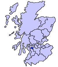
22:East Renfrewshire shown within Scotland
668:British national grid reference system
750:. Historic Environment Scotland. 2016
7:
1025:Lists of category A listed buildings
211:18th-century castellated house by
14:
770:
747:Scotland's Listed Buildings 2016
630:
531:
425:
323:
222:
520:country house, property of the
1:
716:Historic Environment Scotland
90:Historic Environment Scotland
557:Dams to Darnley Country Park
813:Category A listed buildings
522:National Trust for Scotland
59:GPX (secondary coordinates)
1046:
553:Waulkmill Glen Reservoir
352:Mearns Castle High School
138:
124:
121:
118:
54:GPX (primary coordinates)
29:Map all coordinates using
679:"Guide to National Grid"
611:Waulkmill Glen Reservoir
37:Download coordinates as:
495:55.781639°N 4.295752°W
391:55.769683°N 4.309286°W
290:55.786729°N 4.326628°W
189:55.754741°N 4.527262°W
23:
858:Dumfries and Galloway
779:at Wikimedia Commons
600:55.791581°N 4.35785°W
49:GPX (all coordinates)
21:
638:Upload another image
539:Upload another image
500:55.781639; -4.295752
433:Upload another image
396:55.769683; -4.309286
331:Upload another image
295:55.786729; -4.326628
251:Eastwood High School
230:Upload another image
194:55.754741; -4.527262
990:West Dunbartonshire
873:East Dunbartonshire
605:55.791581; -4.35785
595: /
490: /
386: /
285: /
184: /
152:Gleniffer Road, by
98:Scottish Government
1002:na h-Eileanan Siar
354:, Waterfoot Road,
69:This is a list of
24:
1012:
1011:
980:South Lanarkshire
955:Perth and Kinross
945:North Lanarkshire
888:City of Edinburgh
883:East Renfrewshire
775:Media related to
697:. Ordnance Survey
681:. Ordnance Survey
651:
650:
646:
640:
547:
541:
458:, Flenders Road,
441:
435:
339:
333:
253:, Capelrig Road,
238:
232:
78:East Renfrewshire
1037:
965:Scottish Borders
853:Clackmannanshire
833:City of Aberdeen
806:
799:
792:
783:
774:
760:
759:
757:
755:
742:
719:
713:
707:
706:
704:
702:
690:
688:
686:
664:
642:
636:
634:
619:
618:
616:
615:
614:
612:
607:
606:
601:
596:
593:
592:
591:
588:
578:
571:
543:
537:
535:
514:
513:
511:
510:
509:
507:
502:
501:
496:
491:
488:
487:
486:
483:
473:
466:
456:Greenbank Garden
447:Greenbank House
437:
431:
429:
410:
409:
407:
406:
405:
403:
398:
397:
392:
387:
384:
383:
382:
379:
369:
362:
335:
329:
327:
309:
308:
306:
305:
304:
302:
297:
296:
291:
286:
283:
282:
281:
278:
268:
261:
234:
228:
226:
208:
207:
205:
204:
203:
201:
196:
195:
190:
185:
182:
181:
180:
177:
167:
160:
133:Geo-coordinates
130:
116:
112:Listed buildings
94:executive agency
74:listed buildings
1045:
1044:
1040:
1039:
1038:
1036:
1035:
1034:
1015:
1014:
1013:
1008:
1000:Western Isles (
915:City of Glasgow
848:Argyll and Bute
819:
810:
768:
763:
753:
751:
744:
743:
732:
728:
723:
722:
714:
710:
700:
698:
693:
691:
684:
682:
677:
675:
672:Ordnance Survey
665:
661:
656:
644:See more images
641:
610:
608:
604:
602:
598:
597:
594:
589:
586:
584:
582:
581:
574:
570:5 November 2008
569:
545:See more images
542:
506:Greenbank House
505:
503:
499:
497:
493:
492:
489:
484:
481:
479:
477:
476:
469:
464:
439:See more images
436:
401:
399:
395:
393:
389:
388:
385:
380:
377:
375:
373:
372:
365:
360:
337:See more images
334:
300:
298:
294:
292:
288:
287:
284:
279:
276:
274:
272:
271:
264:
259:
236:See more images
233:
199:
197:
193:
191:
187:
186:
183:
178:
175:
173:
171:
170:
163:
158:
114:
67:
66:
65:
64:
63:
12:
11:
5:
1043:
1041:
1033:
1032:
1027:
1017:
1016:
1010:
1009:
1007:
1006:
997:
992:
987:
982:
977:
975:South Ayrshire
972:
967:
962:
957:
952:
947:
942:
940:North Ayrshire
937:
932:
927:
922:
917:
912:
907:
902:
901:
900:
895:
885:
880:
875:
870:
865:
863:City of Dundee
860:
855:
850:
845:
840:
835:
829:
827:
821:
820:
811:
809:
808:
801:
794:
786:
767:
766:External links
764:
762:
761:
729:
727:
724:
721:
720:
708:
658:
657:
655:
652:
649:
648:
628:
623:
620:
579:
572:
567:
554:
550:
549:
529:
524:
515:
474:
467:
462:
452:National Trust
448:
444:
443:
423:
418:
411:
370:
363:
358:
348:
342:
341:
321:
316:
310:
301:Capelrig House
269:
262:
257:
247:
245:Capelrig House
241:
240:
220:
215:
209:
200:Caldwell House
168:
161:
156:
150:
148:Caldwell House
144:
143:
140:
137:
134:
131:
126:
123:
120:
113:
110:
62:
61:
56:
51:
46:
40:
34:
27:
26:
25:
13:
10:
9:
6:
4:
3:
2:
1042:
1031:
1028:
1026:
1023:
1022:
1020:
1005:
1003:
998:
996:
993:
991:
988:
986:
983:
981:
978:
976:
973:
971:
968:
966:
963:
961:
958:
956:
953:
951:
948:
946:
943:
941:
938:
936:
933:
931:
928:
926:
923:
921:
918:
916:
913:
911:
908:
906:
903:
899:
896:
894:
891:
890:
889:
886:
884:
881:
879:
876:
874:
871:
869:
868:East Ayrshire
866:
864:
861:
859:
856:
854:
851:
849:
846:
844:
841:
839:
838:Aberdeenshire
836:
834:
831:
830:
828:
826:
825:Council areas
822:
818:
814:
807:
802:
800:
795:
793:
788:
787:
784:
780:
778:
773:
765:
749:
748:
741:
739:
737:
735:
731:
725:
717:
712:
709:
696:
680:
673:
669:
663:
660:
653:
647:
645:
639:
633:
629:
627:
624:
621:
617:
580:
577:
573:
568:
566:
562:
561:Newton Mearns
558:
555:
552:
548:
546:
540:
534:
530:
528:
525:
523:
519:
516:
512:
475:
472:
468:
463:
461:
457:
453:
449:
446:
442:
440:
434:
428:
424:
422:
419:
416:
413:15th-century
412:
408:
402:Mearns Castle
371:
368:
364:
359:
357:
356:Newton Mearns
353:
349:
347:
346:Mearns Castle
344:
340:
338:
332:
326:
322:
320:
317:
314:
311:
307:
270:
267:
263:
258:
256:
255:Newton Mearns
252:
248:
246:
243:
239:
237:
231:
225:
221:
219:
216:
214:
210:
206:
169:
166:
162:
159:14 April 1971
157:
155:
151:
149:
146:
117:
111:
109:
106:
101:
99:
95:
91:
85:
83:
79:
75:
72:
60:
57:
55:
52:
50:
47:
45:
42:
41:
39:
38:
33:
32:OpenStreetMap
30:
20:
16:
1001:
995:West Lothian
960:Renfrewshire
882:
878:East Lothian
769:
752:. Retrieved
746:
711:
699:. Retrieved
683:. Retrieved
670:used by the
662:
635:
576:NS5226557881
536:
471:NS5612156644
465:10 June 1971
430:
367:NS5522855342
361:10 June 1971
328:
266:NS5420457275
260:10 June 1971
227:
165:NS4149654157
125:Date Listed
105:council area
102:
86:
68:
36:
35:
28:
15:
754:20 February
701:17 December
695:"Get-a-map"
685:12 December
603: /
498: /
415:tower house
394: /
293: /
213:Robert Adam
192: /
139:LB Number
1019:Categories
930:Midlothian
925:Inverclyde
726:References
609: (
587:55°47′30″N
559:, between
504: (
482:55°46′54″N
400: (
378:55°46′11″N
299: (
277:55°47′12″N
198: (
176:55°45′17″N
71:Category A
590:4°21′28″W
485:4°17′45″W
460:Clarkston
381:4°18′33″W
280:4°19′36″W
179:4°31′38″W
154:Uplawmoor
129:Grid Ref.
122:Location
985:Stirling
970:Shetland
920:Highland
898:New Town
893:Old Town
817:Scotland
565:Barrhead
518:Georgian
454:site at
350:Next to
313:Georgian
249:Next to
82:Scotland
905:Falkirk
96:of the
950:Orkney
142:Image
136:Notes
935:Moray
843:Angus
654:Notes
626:51186
527:18537
421:18536
319:18523
218:14255
119:Name
92:, an
910:Fife
756:2017
703:2007
687:2007
563:and
103:The
815:in
450:In
76:in
44:KML
1021::
733:^
692:•
676:•
84:.
80:,
1004:)
805:e
798:t
791:v
758:.
705:.
689:.
674:.
613:)
508:)
404:)
303:)
202:)
Text is available under the Creative Commons Attribution-ShareAlike License. Additional terms may apply.