121:
199:
176:
191:
426:
24:
165:
413:, Albany, has over the past 400 years been called Castle Island, Martin Gerritse's Island, Patroon's Island, Van Rensselaer Island, and since the late 19th century Westerlo Island. (Van Rensselaer Island is also the name of a former island opposite Albany, in the city of Rensselaer.)
147:
is full of islands, though some have been filled in to connect to the shore. Some of the islands have the Hudson on one side and have another river or creek on the other side. Many of the defunct islands are still labeled on
312:, is a designated National Natural Landmark as a National Estuarine Research Reserve and a Significant Coastal Fish and Wildlife Habitat Area. Additionally, is serves as a bird sanctuary for Bald Eagles.
357:
Park Island, also called Island Park – a former island that hosted the Albany County
Agricultural Fair in 1865, had a racetrack in 1866, and an addition of a baseball diamond and clubhouse in 1885.
610:
41:
266:
Center Island, formerly called
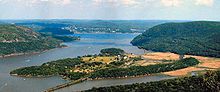
Magills Island and Starbucks Island, it is within the village and town of Green Island, the Hudson River is on both sides, the
615:
585:
120:
524:
605:
88:
60:
576:
198:
107:
67:
581:
74:
45:
56:
175:
369:
34:
410:
352:
571:
384:
Stomy Island, within the village and town of Green Island, Hudson River on both sides, north of Center Island
247:
Breaker Island, formerly two islands called Culyer and
Hillhouse, it is a former island within the town of
519:. Albany Institute of History and Art. Excelsior Editions/State University of New York Press. p. 24.
305:
292:
169:
81:
387:
328:
309:
263:, Hudson River remains on east bank and various creeks, ponds, small lakes, and marshes on the west side
203:
327:(exit 5), Hudson River remains on east bank, is a part of the Corning Preserve, lends its name to the
391:
332:
404:
276:
267:
230:
489:
396:
379:
373:
348:
219:
547:
520:
252:
248:
514:
400:
316:
140:
461:
360:
239:
183:
129:
125:
483:
363:, known for Bannerman's Castle serving as a tourist attraction within the Hudson Valley.
431:
324:
300:
271:
256:
215:
599:
320:
284:
235:
513:
Groft, T.K.; McCombs, W.D.; Greene-McNally, R.; Stilgoe, J.R.; Miles, C.M. (2009).
296:
260:
136:
455:
210:
This list is of past and present islands in the Hudson River and their locations;
242:
23:
421:
223:
144:
425:
344:
337:
179:
508:
506:
403:, Hudson River on east side and a branch of the Mohawk River on the west,
190:
164:
149:
197:
189:
174:
163:
119:
153:
218:, Hudson River on both sides, it is east of Center Island, the
347:, Hudson River on west bank, Papscanee Creek on east bank, in
194:
An aerial still image of Stomy Island taken from the southwest
17:
366:
Schermerhorn Island, a former island in
Bethlehem, New York
449:
447:
445:
443:
315:
Lower
Patroon Island, formerly an island in the city of
319:, was filled in by the construction of interchange of
552:. U.S. Government Printing Office. 1921. p. 2335
485:
A Geological
History of Manhattan Or New York Island
299:'s delta on west side, filled in and replaced with
48:. Unsourced material may be challenged and removed.
488:. W. E. Dean, printer & publisher. p.
516:Hudson River Panorama: A Passage Through Time
255:, filled in by the construction of exit 7 of
8:
160:Past and present islands in the Hudson River
460:. U.S. Government Printing Office. p.
186:was under construction from 1870 until 1883
340:, an island and a borough of New York City
454:United States. Light-House Board (1915).
108:Learn how and when to remove this message
586:United States Department of the Interior
439:
611:Lists of landforms of New York (state)
7:
206:with Albany in the distance, c. 1825
46:adding citations to reliable sources
577:Geographic Names Information System
331:, which connects it to the city of
616:New Jersey geography-related lists
14:
214:Adams Island, within the city of
424:
378:Shad Island, a former island in
229:Bear Island, a former island in
22:
582:United States Geological Survey
33:needs additional citations for
226:over the island's southern tip
57:"List of Hudson River islands"
1:
407:connects it to Troy, New York
606:Islands of the Hudson River
295:, once had a branch of the
632:
238:, southern border of the
343:Papscanee Island, now a
323:(exit not numbered) and
124:The Bannerman Castle on
207:
195:
187:
172:
132:
549:Congressional Edition
399:, within the city of
390:, a former island in
388:Van Rensselaer Island
329:Patroon Island Bridge
310:Stony Point, New York
204:Van Rensselaer Island
201:
193:
178:
167:
123:
482:Cozzens, I. (1843).
392:Rensselaer, New York
333:Rensselaer, New York
42:improve this article
405:112th Street Bridge
277:Constitution Island
268:Green Island Bridge
251:and the village of
231:Bethlehem, New York
397:Van Schaick Island
380:Coeymans, New York
374:Schodack, New York
349:Schodack, New York
220:Collar City Bridge
208:
196:
188:
173:
133:
526:978-1-4384-3256-4
253:Menands, New York
249:Colonie, New York
156:quadrangle maps.
128:viewed from atop
118:
117:
110:
92:
623:
590:
589:
568:
562:
561:
559:
557:
544:
538:
537:
535:
533:
510:
501:
500:
498:
496:
479:
473:
472:
470:
468:
451:
434:
429:
428:
401:Cohoes, New York
317:Albany, New York
289:Five Hook Island
113:
106:
102:
99:
93:
91:
50:
26:
18:
631:
630:
626:
625:
624:
622:
621:
620:
596:
595:
594:
593:
570:
569:
565:
555:
553:
546:
545:
541:
531:
529:
527:
512:
511:
504:
494:
492:
481:
480:
476:
466:
464:
453:
452:
441:
430:
423:
420:
411:Westerlo Island
370:Schodack Island
361:Pollepel Island
270:connects it to
240:Rensselaerswyck
184:Brooklyn Bridge
162:
130:Breakneck Ridge
126:Pollepel Island
114:
103:
97:
94:
51:
49:
39:
27:
12:
11:
5:
629:
627:
619:
618:
613:
608:
598:
597:
592:
591:
572:"Stomy Island"
563:
539:
525:
502:
474:
438:
437:
436:
435:
432:Islands portal
419:
416:
415:
414:
408:
394:
385:
382:
376:
367:
364:
358:
355:
353:East Greenbush
341:
335:
325:Interstate 787
313:
303:
301:Interstate 787
290:
287:
282:
279:
274:
272:Troy, New York
264:
257:Interstate 787
245:
233:
227:
216:Troy, New York
161:
158:
116:
115:
30:
28:
21:
13:
10:
9:
6:
4:
3:
2:
628:
617:
614:
612:
609:
607:
604:
603:
601:
587:
583:
579:
578:
573:
567:
564:
551:
550:
543:
540:
528:
522:
518:
517:
509:
507:
503:
491:
487:
486:
478:
475:
463:
459:
458:
457:Annual Report
450:
448:
446:
444:
440:
433:
427:
422:
417:
412:
409:
406:
402:
398:
395:
393:
389:
386:
383:
381:
377:
375:
371:
368:
365:
362:
359:
356:
354:
350:
346:
342:
339:
336:
334:
330:
326:
322:
321:Interstate 90
318:
314:
311:
308:, located in
307:
304:
302:
298:
294:
291:
288:
286:
285:Esopus Island
283:
280:
278:
275:
273:
269:
265:
262:
258:
254:
250:
246:
244:
241:
237:
236:Beeren Island
234:
232:
228:
225:
221:
217:
213:
212:
211:
205:
200:
192:
185:
182:in 1873. The
181:
177:
171:
166:
159:
157:
155:
151:
146:
142:
138:
131:
127:
122:
112:
109:
101:
98:February 2019
90:
87:
83:
80:
76:
73:
69:
66:
62:
59: –
58:
54:
53:Find sources:
47:
43:
37:
36:
31:This article
29:
25:
20:
19:
16:
575:
566:
556:February 28,
554:. Retrieved
548:
542:
532:February 28,
530:. Retrieved
515:
495:February 28,
493:. Retrieved
484:
477:
467:February 28,
465:. Retrieved
456:
297:Mohawk River
293:Green Island
261:NY Route 378
209:
137:Hudson River
134:
104:
95:
85:
78:
71:
64:
52:
40:Please help
35:verification
32:
15:
306:Iona Island
243:patroonship
202:The former
170:Iona Island
600:Categories
418:References
281:Cow Island
224:NY Route 7
168:A view of
145:New Jersey
68:newspapers
345:peninsula
338:Manhattan
180:Manhattan
222:carries
141:New York
82:scholar
523:
150:NYSDOT
84:
77:
70:
63:
55:
372:, in
259:with
89:JSTOR
75:books
558:2019
534:2019
521:ISBN
497:2019
469:2019
351:and
154:USGS
152:and
143:and
135:The
61:news
139:in
44:by
602::
584:,
580:.
574:.
505:^
490:11
462:31
442:^
588:.
560:.
536:.
499:.
471:.
111:)
105:(
100:)
96:(
86:·
79:·
72:·
65:·
38:.
Text is available under the Creative Commons Attribution-ShareAlike License. Additional terms may apply.