31:
47:
54:
192:
409:
By the beginning of the 19th century, Litchurch's population was still only 35. The coming of the railway industry to Derby from 1839 onwards, however, was the catalyst for a huge expansion of the local population, including areas outside the historic borough boundaries. Over the next few decades, an
448:
Since being abolished it has had no officially defined administrative function. Indeed the use of the name itself has fallen into decline in recent decades, many of the residential streets at the heart of 19th century
Litchurch having been obliterated in the 1970s to facilitate the expansion of the
430:. The Osmaston Road area contained the Derby workhouse, but was also home to many prominent middle class residents living in large houses such as The Field, at one time occupied by Midland Railway engineer
232:
441:, on 26 March 1898 the parish was abolished and merged with Derby and became part of the county borough of Derby. In 1891 the parish had a population of 23,003. It is now in the
460:. A street name-plate located on Normanton Road, next to Grove Street, identifies the area as "Normanton Road- Litchurch". The area also had a gallows located in what is now
216:
364:
of
Derbyshire, meaning that at one time it was the meeting place for the hundred court. By 1300, it had been combined with the neighbouring hundred of Morleston.
1005:
240:
726:
178:
30:
621:
328:
boundary, before experiencing rapid urbanisation and population growth in the 19th century. After a brief existence as a self-governing
204:
46:
379:
of
Litchurch was joined to the holdings of Peter de Sandiacre. As a consequence of this reorganisation, Litchurch now lay outside the
209:
557:
501:
577:
258:
276:
394:
Over the next five hundred years
Litchurch remained a rural backwater on the fringes of Derby, and by 1700 was described as a "
221:
166:
132:
719:
419:
96:
517:
361:
399:
268:
353:
469:
450:
598:
712:
263:
146:
1000:
352:. This church has not been identified with certainty, but it may refer to an early settlement around nearby
197:
775:
415:
329:
431:
78:
388:
929:
894:
755:
395:
384:
321:
114:
780:
974:
874:
553:
497:
949:
934:
914:
819:
809:
668:
171:
944:
854:
833:
465:
461:
442:
423:
411:
380:
410:
ever-increasing number of Derby's amenities came to be located in
Litchurch: much of the
939:
904:
869:
824:
770:
333:
704:
994:
799:
698:
357:
122:
959:
889:
794:
693:
438:
403:
372:
368:
521:
427:
376:
345:
646:
954:
924:
909:
884:
879:
814:
804:
790:
785:
740:
317:
104:
67:
573:
291:
278:
979:
919:
859:
760:
156:
864:
765:
969:
838:
138:
964:
829:
406:
and came into the use of £4,000 and lands and property in
Litchurch.
736:
332:
between 1866 and 1889, it was absorbed by the newly created Derby
325:
313:
86:
371:
in 1203, St Peter's Church was transferred to the control of the
708:
622:"Controversial Litchurch annexation was the Brexit of its day"
398:
of itself but no house, only three or four cottages". In 1757
647:"Relationships and changes Litchurch CP/Tn through time"
599:"Borough Estate and Family Papers - Access to Archives"
669:"Population statistics Litchurch CP/Tn through time"
847:
748:
620:Rippon, Nicola; Goddard, Jane (17 September 2018).
231:
215:
203:
191:
177:
165:
155:
145:
131:
113:
95:
77:
23:
356:. The earliest reference to Litchurch is in the
574:"History of Litchurch, in Derby and Derbyshire"
320:, England. From Medieval times it was a rural
720:
367:Around the time that Derby was granted a new
8:
336:and has subsequently fallen into obscurity.
402:, Derby's Town Clerk, married Anne Ault of
727:
713:
705:
494:The illustrated history of Derby's suburbs
20:
487:
485:
543:
541:
539:
496:. Derby: Breedon Books. pp. 62–72.
481:
456:An early map of Derby dated 1819 shows
383:boundary and was classed as a separate
230:
186:
154:
130:
27:
324:associated with Derby but outside the
214:
202:
190:
176:
164:
144:
112:
94:
76:
7:
437:In 1866 Litchurch became a separate
312:is a historical area in the city of
1006:Former civil parishes in Derbyshire
671:. A Vision of Britain through Time
649:. A Vision of Britain through Time
464:. Litchurch leant its name to the
14:
445:of Derby, in the Derby district.
53:
578:A Vision of Britain through Time
518:"Domesday Map Online: Litchurch"
52:
45:
29:
420:Derby Carriage and Wagon Works
1:
414:'s properties, including the
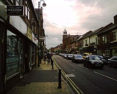
35:Normanton Road in Litchurch
18:Human settlement in England
1022:
470:Derby Litchurch Lane Works
451:Derbyshire Royal Infirmary
360:when it was also one the
344:The name Litchurch is of
249:
227:
187:
40:
28:
552:. Derby: Breedon Books.
548:Craven, Maxwell (2005).
492:Craven, Maxwell (1996).
458:The Liberty Of Litchurch
354:St Peter's Church, Derby
601:. The National Archives
550:Derby: Street by Street
167:Postcode district
97:Ceremonial county
79:Unitary authority
432:William Henry Barlow
147:Sovereign state
524:on 23 February 2015
288: /
895:Heatherton Village
233:UK Parliament
179:Dialling code
988:
987:
426:and parts of the
307:
306:
1013:
729:
722:
715:
706:
681:
680:
678:
676:
665:
659:
658:
656:
654:
643:
637:
636:
634:
632:
617:
611:
610:
608:
606:
595:
589:
588:
586:
584:
570:
564:
563:
545:
534:
533:
531:
529:
520:. Archived from
514:
508:
507:
489:
348:origin, meaning
330:local board area
303:
302:
300:
299:
298:
293:
292:52.914°N 1.471°W
289:
286:
285:
284:
281:
255:
141:
66:Location within
56:
55:
49:
33:
21:
1021:
1020:
1016:
1015:
1014:
1012:
1011:
1010:
991:
990:
989:
984:
843:
744:
733:
690:
685:
684:
674:
672:
667:
666:
662:
652:
650:
645:
644:
640:
630:
628:
619:
618:
614:
604:
602:
597:
596:
592:
582:
580:
572:
571:
567:
560:
547:
546:
537:
527:
525:
516:
515:
511:
504:
491:
490:
483:
478:
466:Midland Railway
462:Derby Arboretum
443:unparished area
424:Derby Arboretum
416:railway station
412:Midland Railway
373:Abbey of Darley
342:
296:
294:
290:
287:
282:
279:
277:
275:
274:
273:
253:
245:
137:
127:
109:
91:
73:
72:
71:
70:
64:
63:
62:
61:
57:
36:
19:
12:
11:
5:
1019:
1017:
1009:
1008:
1003:
1001:Areas of Derby
993:
992:
986:
985:
983:
982:
977:
972:
967:
962:
957:
952:
947:
942:
937:
932:
927:
922:
917:
912:
907:
905:Little Chester
902:
897:
892:
887:
882:
877:
872:
867:
862:
857:
851:
849:
845:
844:
842:
841:
836:
827:
822:
817:
812:
807:
802:
797:
788:
783:
778:
773:
771:Alvaston South
768:
766:Alvaston North
763:
758:
752:
750:
746:
745:
734:
732:
731:
724:
717:
709:
703:
702:
689:
688:External links
686:
683:
682:
660:
638:
626:DerbyshireLive
612:
590:
565:
558:
535:
509:
502:
480:
479:
477:
474:
389:Derby-St Peter
341:
338:
334:county borough
305:
304:
297:52.914; -1.471
272:
271:
266:
261:
256:
254:List of places
250:
247:
246:
244:
243:
241:Mid Derbyshire
237:
235:
229:
228:
225:
224:
219:
213:
212:
207:
201:
200:
195:
189:
188:
185:
184:
181:
175:
174:
169:
163:
162:
159:
153:
152:
151:United Kingdom
149:
143:
142:
135:
129:
128:
126:
125:
119:
117:
111:
110:
108:
107:
101:
99:
93:
92:
90:
89:
83:
81:
75:
74:
65:
59:
58:
51:
50:
44:
43:
42:
41:
38:
37:
34:
26:
25:
17:
13:
10:
9:
6:
4:
3:
2:
1018:
1007:
1004:
1002:
999:
998:
996:
981:
978:
976:
973:
971:
968:
966:
963:
961:
958:
956:
953:
951:
948:
946:
943:
941:
938:
936:
933:
931:
928:
926:
923:
921:
918:
916:
913:
911:
908:
906:
903:
901:
898:
896:
893:
891:
888:
886:
883:
881:
878:
876:
873:
871:
868:
866:
863:
861:
858:
856:
853:
852:
850:
846:
840:
837:
835:
831:
828:
826:
823:
821:
818:
816:
813:
811:
808:
806:
803:
801:
798:
796:
792:
789:
787:
784:
782:
779:
777:
774:
772:
769:
767:
764:
762:
759:
757:
754:
753:
751:
747:
742:
738:
730:
725:
723:
718:
716:
711:
710:
707:
701:
700:
699:Domesday Book
695:
692:
691:
687:
670:
664:
661:
648:
642:
639:
627:
623:
616:
613:
600:
594:
591:
579:
575:
569:
566:
561:
559:1-85983-426-4
555:
551:
544:
542:
540:
536:
523:
519:
513:
510:
505:
503:9781859830314
499:
495:
488:
486:
482:
475:
473:
471:
467:
463:
459:
454:
452:
449:neighbouring
446:
444:
440:
435:
433:
429:
425:
422:, as well as
421:
417:
413:
407:
405:
401:
400:Thomas Borrow
397:
392:
390:
386:
382:
378:
374:
370:
365:
363:
359:
358:Domesday Book
355:
351:
350:Luda's Church
347:
339:
337:
335:
331:
327:
323:
319:
315:
311:
301:
270:
267:
265:
262:
260:
257:
252:
251:
248:
242:
239:
238:
236:
234:
226:
223:
222:East Midlands
220:
218:
211:
208:
206:
199:
196:
194:
182:
180:
173:
170:
168:
160:
158:
150:
148:
140:
136:
134:
124:
123:East Midlands
121:
120:
118:
116:
106:
103:
102:
100:
98:
88:
85:
84:
82:
80:
69:
48:
39:
32:
22:
16:
960:Shelton Lock
899:
890:Darley Abbey
795:Shelton Lock
697:
673:. Retrieved
663:
651:. Retrieved
641:
629:. Retrieved
625:
615:
603:. Retrieved
593:
581:. Retrieved
568:
549:
526:. Retrieved
522:the original
512:
493:
457:
455:
447:
439:civil parish
436:
408:
404:Loughborough
393:
375:, while the
369:town charter
366:
349:
343:
309:
308:
15:
930:New Zealand
528:23 February
428:Derby Canal
346:Anglo-Saxon
295: /
995:Categories
975:Sunny Hill
955:Pride Park
925:Mickleover
910:Littleover
885:Chellaston
880:Chaddesden
875:California
815:Mickleover
805:Littleover
791:Chellaston
786:Chaddesden
781:Blagreaves
741:Derbyshire
476:References
318:Derbyshire
280:52°54′50″N
269:Derbyshire
210:Derbyshire
198:Derbyshire
105:Derbyshire
68:Derbyshire
980:Wilmorton
950:Pear Tree
935:Normanton
920:Markeaton
915:Mackworth
900:Litchurch
860:Allestree
820:Normanton
810:Mackworth
776:Arboretum
761:Allestree
743:, England
735:Areas of
694:Litchurch
310:Litchurch
283:1°28′16″W
217:Ambulance
157:Post town
60:Litchurch
24:Litchurch
945:Osmaston
865:Alvaston
855:Allenton
834:Osmaston
675:24 April
653:24 April
583:24 April
418:and the
385:township
362:hundreds
322:township
970:Spondon
940:Oakwood
870:Boulton
839:Spondon
825:Oakwood
696:in the
631:6 April
605:16 July
396:liberty
387:within
381:borough
340:History
264:England
139:England
133:Country
965:Sinfin
830:Sinfin
800:Darley
556:
500:
193:Police
115:Region
848:Areas
756:Abbey
749:Wards
737:Derby
377:manor
326:burgh
316:, in
314:Derby
183:01332
161:DERBY
87:Derby
832:and
793:and
677:2024
655:2024
633:2023
607:2011
585:2024
554:ISBN
530:2015
498:ISBN
205:Fire
468:'s
997::
739:,
624:.
576:.
538:^
484:^
472:.
453:.
434:.
391:.
259:UK
172:DE
728:e
721:t
714:v
679:.
657:.
635:.
609:.
587:.
562:.
532:.
506:.
Text is available under the Creative Commons Attribution-ShareAlike License. Additional terms may apply.