527:
63:
332:
47:
70:
523:
Little Grass Valley Dam is a rock-fill dam 840 feet (260 m) long and 210 feet (64 m) high, with 18 feet (5.5 m) of freeboard. The South
Feather Water and Power Agency owns the dam.
551:, managed by the Feather River Ranger District. The area supports boating, camping, fishing, swimming, picnicking, horseback riding, mountain biking, wildlife viewing, and hiking.
105:
766:
781:
776:
572:
626:
362:
62:
669:
617:
771:
622:
28:
526:
563:. The Pacific Crest Trail passes north of the lake and can be reached by way of the Bald Mountain Trail from Horse Camp.
577:
350:
270:
91:
587:
428:
308:
168:
612:
540:
274:
560:
161:
544:
278:
149:
676:
728:
257:
704:
496:
185:
175:
17:
675:. California Department of Water Resources, Division of Safety of Dams. Archived from
760:
137:
156:
South Fork
Feather River, Black Rock Creek, Ice Creek, Pancake Ravine, Kenzie Ravine
582:
331:
46:
377:
364:
120:
107:
142:
150:
162:
27:
This article is about the lake. For the census-designated place, see
525:
670:"Dams Within the Jurisdiction of the State of California (H-M)"
729:"Plumas National Forest - Little Grass Valley Recreation Area"
415:
748:
547:, Little Grass Valley Reservoir is the centerpiece of the
69:
513:
505:
495:
487:
479:
474:
466:
458:
450:
442:
434:
424:
414:
409:
401:
393:
356:
346:
338:
324:
247:
239:
231:
223:
215:
207:
199:
195:
184:
174:
160:
148:
136:
97:
87:
39:
288:(National ID CA00269), which was completed in 1961
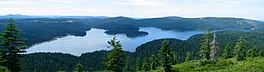
51:The reservoir in 2004, viewed from Bald Mountain.
98:
559:By car, the lake is about ninety minutes from
8:
330:
321:
36:
573:List of dams and reservoirs in California
699:
697:
627:United States Department of the Interior
767:Reservoirs in Plumas County, California
599:
664:
662:
660:
658:
656:
607:
605:
603:
34:Reservoir in Plumas County, California
782:Artificial lakes of the United States
705:"Little Grass Valley Recreation Area"
654:
652:
650:
648:
646:
644:
642:
640:
638:
636:
491:93,010 acre-feet (114,730,000 m)
235:93,010 acre-feet (114,730,000 m)
7:
470:834,000 cubic yards (638,000 m)
405:South Feather Water and Power Agency
618:Geographic Names Information System
549:Little Grass Valley Recreation Area
284:The lake's waters are impounded by
25:
777:Reservoirs in Northern California
319:Dam in Plumas County, California
68:
61:
45:
623:United States Geological Survey
613:"Little Grass Valley Reservoir"
246:
238:
230:
222:
214:
206:
198:
29:Little Grass Valley, California
501:25.9 square miles (67 km)
180:25.9 square miles (67 km)
1:
483:Little Grass Valley Reservoir
307:The lake discharges into the
267:Little Grass Valley Reservoir
86:
76:Little Grass Valley Reservoir
40:Little Grass Valley Reservoir
451:Elevation at crest
578:List of lakes in California
798:
258:not a well-defined measure
26:
454:5,052 feet (1,540 m)
351:Plumas County, California
329:
271:Plumas County, California
269:is an artificial lake in
255:
251:5,036 feet (1,535 m)
243:14.5 miles (23.3 km)
219:1,433 acres (580 ha)
92:Plumas County, California
56:
44:
772:Reservoirs in California
588:Grass Valley, California
429:South Fork Feather River
309:South Fork Feather River
290: (63 years ago)
169:South Fork Feather River
325:Little Grass Valley Dam
315:Little Grass Valley Dam
286:Little Grass Valley Dam
18:Little Grass Valley Dam
541:Plumas National Forest
531:
378:39.72167°N 121.02278°W
275:Plumas National Forest
121:39.72917°N 120.99028°W
529:
509:2 miles (3.2 km)
446:840 feet (260 m)
416:Type of dam
203:2 miles (3.2 km)
517:1 mile (1.6 km)
462:30 feet (9.1 m)
438:210 feet (64 m)
383:39.72167; -121.02278
211:1 mile (1.6 km)
126:39.72917; -120.99028
682:on December 6, 2012
545:Pacific Crest Trail
506:Maximum length
497:Catchment area
488:Total capacity
374: /
279:Pacific Crest Trail
227:65 feet (20 m)
117: /
532:
514:Maximum width
459:Width (crest)
521:
520:
410:Dam and spillways
394:Opening date
264:
263:
248:Surface elevation
16:(Redirected from
789:
751:
746:
740:
739:
737:
735:
725:
719:
718:
716:
714:
709:
701:
692:
691:
689:
687:
681:
674:
666:
631:
630:
609:
389:
388:
386:
385:
384:
379:
375:
372:
371:
370:
367:
334:
322:
298:
296:
291:
256:Shore length is
164:
163:Primary outflows
152:
132:
131:
129:
128:
127:
122:
118:
115:
114:
113:
110:
100:
72:
71:
65:
49:
37:
21:
797:
796:
792:
791:
790:
788:
787:
786:
757:
756:
755:
754:
747:
743:
733:
731:
727:
726:
722:
712:
710:
707:
703:
702:
695:
685:
683:
679:
672:
668:
667:
634:
611:
610:
601:
596:
569:
557:
537:
467:Dam volume
382:
380:
376:
373:
368:
365:
363:
361:
360:
320:
317:
305:
294:
292:
289:
188: countries
151:Primary inflows
125:
123:
119:
116:
111:
108:
106:
104:
103:
83:
82:
81:
80:
79:
78:
77:
73:
52:
35:
32:
23:
22:
15:
12:
11:
5:
795:
793:
785:
784:
779:
774:
769:
759:
758:
753:
752:
741:
720:
693:
632:
598:
597:
595:
592:
591:
590:
585:
580:
575:
568:
565:
556:
553:
536:
533:
519:
518:
515:
511:
510:
507:
503:
502:
499:
493:
492:
489:
485:
484:
481:
477:
476:
472:
471:
468:
464:
463:
460:
456:
455:
452:
448:
447:
444:
440:
439:
436:
432:
431:
426:
422:
421:
418:
412:
411:
407:
406:
403:
399:
398:
395:
391:
390:
358:
354:
353:
348:
344:
343:
340:
336:
335:
327:
326:
318:
316:
313:
304:
301:
262:
261:
253:
252:
249:
245:
244:
241:
237:
236:
233:
229:
228:
225:
221:
220:
217:
213:
212:
209:
205:
204:
201:
197:
196:
193:
192:
189:
182:
181:
178:
176:Catchment area
172:
171:
166:
158:
157:
154:
146:
145:
140:
134:
133:
101:
95:
94:
89:
85:
84:
75:
74:
67:
66:
60:
59:
58:
57:
54:
53:
50:
42:
41:
33:
24:
14:
13:
10:
9:
6:
4:
3:
2:
794:
783:
780:
778:
775:
773:
770:
768:
765:
764:
762:
750:
745:
742:
730:
724:
721:
706:
700:
698:
694:
678:
671:
665:
663:
661:
659:
657:
655:
653:
651:
649:
647:
645:
643:
641:
639:
637:
633:
628:
624:
620:
619:
614:
608:
606:
604:
600:
593:
589:
586:
584:
581:
579:
576:
574:
571:
570:
566:
564:
562:
554:
552:
550:
546:
542:
534:
528:
524:
516:
512:
508:
504:
500:
498:
494:
490:
486:
482:
478:
473:
469:
465:
461:
457:
453:
449:
445:
441:
437:
433:
430:
427:
423:
419:
417:
413:
408:
404:
400:
396:
392:
387:
359:
355:
352:
349:
345:
342:United States
341:
337:
333:
328:
323:
314:
312:
310:
302:
300:
287:
282:
280:
276:
272:
268:
259:
254:
250:
242:
234:
226:
224:Average depth
218:
210:
202:
194:
191:United States
190:
187:
183:
179:
177:
173:
170:
167:
165:
159:
155:
153:
147:
144:
141:
139:
135:
130:
102:
96:
93:
90:
64:
55:
48:
43:
38:
30:
19:
744:
734:December 21,
732:. Retrieved
723:
713:December 21,
711:. Retrieved
686:December 21,
684:. Retrieved
677:the original
616:
583:Grass valley
558:
548:
538:
522:
306:
285:
283:
266:
265:
240:Shore length
232:Water volume
216:Surface area
749:Google maps
539:Located in
381: /
369:121°01′22″W
357:Coordinates
200:Max. length
124: /
112:120°59′25″W
99:Coordinates
761:Categories
594:References
535:Recreation
366:39°43′18″N
208:Max. width
109:39°43′45″N
561:Yuba City
543:near the
475:Reservoir
303:Hydrology
277:near the
143:reservoir
567:See also
425:Impounds
420:Rockfill
402:Owner(s)
347:Location
88:Location
480:Creates
339:Country
293: (
555:Access
443:Length
435:Height
708:(PDF)
680:(PDF)
673:(PDF)
186:Basin
736:2012
715:2012
688:2012
530:Lake
397:1961
295:1961
273:and
138:Type
763::
696:^
635:^
625:,
621:.
615:.
602:^
311:.
299:.
281:.
738:.
717:.
690:.
629:.
297:)
260:.
31:.
20:)
Text is available under the Creative Commons Attribution-ShareAlike License. Additional terms may apply.