181:
138:
174:
131:
29:
415:
Dibblee, T.W., and
Ehrenspeck, H.E., ed., 1987, Geologic map of the San Marcos Pass quadrangle, Santa Barbara County, California: Dibblee Geological Foundation, Dibblee Foundation Map DF-08, scale 1:24,000
436:
86:
313:
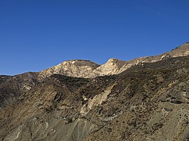
unit usually found much farther north, encircling the high ridge of the mountain. North slope outcrops consist largely of Espada
Formation rocks, with a band of
173:
446:
375:
130:
51:
283:
441:
366:
256:
150:
371:
226:
431:
79:
260:
287:
361:
59:
310:
294:
297:, which creates serpentine soils that support a unique chaparral ecosystem. Large deposits of dark-red
395:
264:
214:
306:
69:
271:, from the drainage of Santa Cruz Creek, which flows into the middle section of the river via
302:
268:
221:
207:
425:
158:
28:
314:
276:
272:
239:
290:
during the winter months. There is a camp at Happy Hollow Spring near the summit.
301:
are exposed above ground. The middle slopes of the mountain are dominated by the
337:
154:
101:
88:
298:
286:, and is a popular day hike and mountain biking route for residents of
267:. It separates the drainages of Oso Creek, which flows into the upper
44:
293:
The rocks of the lower slopes of the mountain comes from the
33:
Little Pine
Mountain is on the right edge of the photo
246:
Dirt road (Buckhorn-Camuesa OHV to Little Pine Road)
238:
233:
220:
206:
117:
78:
68:
58:
43:
38:
21:
309:. There is a small band of Temblor Formation, a
437:Mountains of Santa Barbara County, California
8:
275:. The mountain is named for a thin grove of
180:
137:
18:
376:United States Department of the Interior
193:Little Pine Mountain (the United States)
326:
317:splitting the Espada section in half.
16:Mountain in California, United States
7:
332:
330:
284:Santa Cruz National Recreation Trail
367:Geographic Names Information System
396:"Little Pine Mountain and 19 Oaks"
338:"Little Pine Mountain, California"
14:
305:. The summit largely consists of
447:Mountains of Southern California
257:Santa Barbara County, California
179:
172:
136:
129:
27:
372:United States Geological Survey
282:The mountain is reached by the
1:
196:Show map of the United States
263:at the southern edge of the
49:4,462 ft (1,360 m)
463:
442:Los Padres National Forest
261:Los Padres National Forest
122:
26:
64:518 ft (158 m)
398:. SantaBarbaraHikes.com
279:located on the summit.
362:"Little Pine Mountain"
163:Show map of California
102:34.60056°N 119.73889°W
311:Great Valley Sequence
295:Franciscan Assemblage
74:Lower Peaks Committee
432:San Rafael Mountains
265:San Rafael Mountains
253:Little Pine Mountain
215:San Rafael Mountains
187:Little Pine Mountain
151:Santa Barbara County
144:Little Pine Mountain
107:34.60056; -119.73889
22:Little Pine Mountain
98: /
307:Matilija Sandstone
52: NAVD 88
39:Highest point
255:is a mountain in
250:
249:
54:
454:
416:
413:
407:
406:
404:
403:
392:
386:
385:
383:
382:
358:
352:
351:
349:
348:
334:
303:Espada Formation
269:Santa Ynez River
242:
210:
197:
183:
182:
176:
164:
140:
139:
133:
113:
112:
110:
109:
108:
103:
99:
96:
95:
94:
91:
50:
31:
19:
462:
461:
457:
456:
455:
453:
452:
451:
422:
421:
420:
419:
414:
410:
401:
399:
394:
393:
389:
380:
378:
360:
359:
355:
346:
344:
336:
335:
328:
323:
240:
229:San Marcos Pass
208:
202:
201:
200:
199:
198:
195:
194:
191:
190:
189:
188:
184:
167:
166:
165:
162:
161:
148:
147:
146:
145:
141:
106:
104:
100:
97:
92:
89:
87:
85:
84:
34:
17:
12:
11:
5:
460:
458:
450:
449:
444:
439:
434:
424:
423:
418:
417:
408:
387:
353:
342:Peakbagger.com
325:
324:
322:
319:
248:
247:
244:
236:
235:
231:
230:
224:
218:
217:
212:
204:
203:
192:
186:
185:
178:
177:
171:
170:
169:
168:
149:
143:
142:
135:
134:
128:
127:
126:
125:
124:
123:
120:
119:
115:
114:
82:
76:
75:
72:
66:
65:
62:
56:
55:
47:
41:
40:
36:
35:
32:
24:
23:
15:
13:
10:
9:
6:
4:
3:
2:
459:
448:
445:
443:
440:
438:
435:
433:
430:
429:
427:
412:
409:
397:
391:
388:
377:
373:
369:
368:
363:
357:
354:
343:
339:
333:
331:
327:
320:
318:
316:
312:
308:
304:
300:
296:
291:
289:
288:Santa Barbara
285:
280:
278:
277:Coulter pines
274:
270:
266:
262:
258:
254:
245:
243:
241:Easiest route
237:
232:
228:
225:
223:
219:
216:
213:
211:
205:
175:
160:
156:
152:
132:
121:
116:
111:
83:
81:
77:
73:
71:
67:
63:
61:
57:
53:
48:
46:
42:
37:
30:
25:
20:
411:
400:. Retrieved
390:
379:. Retrieved
365:
356:
345:. Retrieved
341:
315:serpentinite
292:
281:
273:Lake Cachuma
252:
251:
209:Parent range
105: /
93:119°44′20″W
80:Coordinates
426:Categories
402:2014-09-12
381:2014-09-14
347:2014-09-12
321:References
155:California
90:34°36′02″N
60:Prominence
259:, in the
118:Geography
45:Elevation
299:cinnabar
234:Climbing
222:Topo map
70:Listing
227:USGS
159:U.S.
428::
374:,
370:.
364:.
340:.
329:^
157:,
153:,
405:.
384:.
350:.
Text is available under the Creative Commons Attribution-ShareAlike License. Additional terms may apply.