29:
336:
visited Little Rock Creek in 1853, as they surveyed the north slope of the San
Gabriel Mountains. The first non-native settlement in the area was Santiago García, who was born circa 1833. He built an adobe on the north side of Little Rock Creek approximately 0.5 miles (0.80 km) to the east of
385:), a factor leading to the closure of Little Rock Road and the forested areas upstream from the reservoir. The upper segment of the creek is located in the newly designated Pleasant View Ridge Wilderness area and supports an important population of endangered
357:
and flows down the north slope of the San
Gabriel Mountains. Its main tributaries are South Fork Little Rock Creek and then Santiago Canyon Creek just before reaching Little Rock Reservoir. At
299:
765:
785:
191:
717:
126:
314:
According to the toponomastic scholar, Erwin Gudde, "little" often refers to a place name when it is near to a larger geographic feature, in this case
672:
658:
630:
602:
549:
452:
750:
397:
790:
649:
621:
593:
540:
443:
28:
654:
626:
598:
545:
448:
354:
100:
770:
273:
67:
721:
409:
365:
which terminates in the
Antelope Valley. Little Rock Creek is part of the Antelope Valley Watershed, which is a closed
386:
345:(canyon) was located. Santiago Garcia was killed in 1873 by a grizzly bear in what was later named Santiago Canyon.
469:
746:
U.S. Geological Survey
Geographic Names Information System: Guadalupe Creek - Geographic Names Information System
319:
775:
745:
644:
616:
588:
535:
438:
325:
280:
284:
177:
780:
77:
265:
112:
362:
329:
81:
696:
512:
338:
567:
337:
where the creek turned from north to east near Totem Pole Ranch. At this wet spot, where the
473:
366:
358:
292:
288:
306:
for any fish caught in Little Rock
Reservoir due to elevated levels of mercury and PCBs.
487:
303:
396:
The Little Rock Creek watershed was protected by the
October, 2014 designation of the
759:
269:
47:
465:
U.S. Geological Survey. National
Hydrography Dataset high-resolution flowline data.
353:
Little Rock Creek's originates just west of the summit of 8,199 feet (2,499 m)
378:
172:
514:
California Place Names: The Origin and
Etymology of Current Geographical Names
333:
57:
206:
193:
141:
128:
697:"Little Rock Recreation Area Now Under Permit and Managed by Concessionaire"
466:
342:
261:
369:
with no outlet. It is part of the South
Lahontan Hydrologic Region.
291:. After released there it flows through Little Rock Wash into the
283:, just west of Mount Williamson peak. Downstream the creek enters
33:
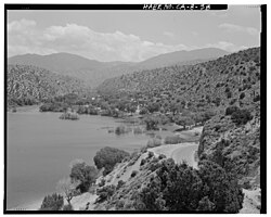
View to south over reservoir into Little Rock Creek
Watershed
568:"Mining and Ranching in Soledad Canyon and Antelope Valley"
300:
California Office of Environmental Health Hazard Assessment
678:(Report). California Department of Water Resources. 2013
673:
South Lahontan Hydrologic Region: California Water Plan
260:
is a 16.7-mile (26.9 km) northwestward-flowing
251:
South Fork Little Rock Creek, Santiago Canyon Creek
245:
237:
232:
222:
183:
171:
157:
118:
106:
96:
87:
73:
63:
53:
43:
38:
21:
377:Lower Little Rock Creek is home to the endangered
517:. University of California Press. p. C-179
341:system forced water to the surface, the Garcia
8:
570:. Santa Clarita Valley Historical Society
766:Rivers of Los Angeles County, California
718:"San Gabriel Wild & Scenic Campaign"
659:United States Department of the Interior
631:United States Department of the Interior
603:United States Department of the Interior
550:United States Department of the Interior
453:United States Department of the Interior
786:San Gabriel Mountains National Monument
561:
559:
421:
398:San Gabriel Mountains National Monument
720:. Friends of the River. Archived from
433:
431:
429:
427:
425:
18:
7:
650:Geographic Names Information System
622:Geographic Names Information System
594:Geographic Names Information System
541:Geographic Names Information System
444:Geographic Names Information System
14:
27:
655:United States Geological Survey
627:United States Geological Survey
599:United States Geological Survey
546:United States Geological Survey
449:United States Geological Survey
589:"South Fork Little Rock Creek"
330:Lt. Robert Stockton Williamson
295:of the western Mojave Desert.
274:Los Angeles County, California
185: • coordinates
120: • coordinates
1:
791:Rivers of Southern California
88:Physical characteristics
476:, accessed November 30, 2014
410:List of rivers of California
224: • elevation
163:8,000 ft (2,400 m)
159: • elevation
486:Admin, OEHHA (2014-03-24).
387:mountain yellow-legged frog
108: • location
807:
566:David Earle (2003-01-08).
279:Its headwaters are in the
228:3,268 ft (996 m)
302:has issued a safe eating
167:
92:
26:
16:Stream in California, US
511:Erwin G. Gudde (1960).
488:"Little Rock Reservoir"
326:Pacific Railroad Survey
281:Angeles National Forest
247: • left
207:34.46917°N 118.01972°W
142:34.37111°N 117.85972°W
771:San Gabriel Mountains
699:. USDA Forest Service
383:Anaxyrus californicus
285:Little Rock Reservoir
266:San Gabriel Mountains
178:Little Rock Reservoir
113:San Gabriel Mountains
751:Friends of the River
349:Watershed and Course
212:34.46917; -118.01972
147:34.37111; -117.85972
439:"Little Rock Creek"
233:Basin features
203: /
138: /
645:"Little Rock Wash"
472:2012-03-29 at the
334:Colonel John Parke
272:, within northern
68:Los Angeles County
617:"Santiago Canyon"
339:San Andreas Fault
316:Little Rock Creek
258:Little Rock Creek
255:
254:
22:Little Rock Creek
798:
733:
732:
730:
729:
714:
708:
707:
705:
704:
693:
687:
686:
684:
683:
677:
669:
663:
662:
641:
635:
634:
613:
607:
606:
585:
579:
578:
576:
575:
563:
554:
553:
536:"Big Rock Creek"
532:
526:
525:
523:
522:
508:
502:
501:
499:
498:
483:
477:
467:The National Map
463:
457:
456:
435:
363:Little Rock Wash
355:Mount Williamson
248:
218:
217:
215:
214:
213:
208:
204:
201:
200:
199:
196:
160:
153:
152:
150:
149:
148:
143:
139:
136:
135:
134:
131:
121:
109:
101:Mount Williamson
31:
19:
806:
805:
801:
800:
799:
797:
796:
795:
776:Antelope Valley
756:
755:
742:
737:
736:
727:
725:
716:
715:
711:
702:
700:
695:
694:
690:
681:
679:
675:
671:
670:
666:
643:
642:
638:
615:
614:
610:
587:
586:
582:
573:
571:
565:
564:
557:
534:
533:
529:
520:
518:
510:
509:
505:
496:
494:
485:
484:
480:
474:Wayback Machine
464:
460:
437:
436:
423:
418:
406:
375:
367:endorheic basin
359:Little Rock Dam
351:
318:being close to
312:
293:Antelope Valley
289:Little Rock Dam
287:, impounded by
246:
225:
211:
209:
205:
202:
197:
194:
192:
190:
189:
186:
158:
146:
144:
140:
137:
132:
129:
127:
125:
124:
119:
107:
34:
17:
12:
11:
5:
804:
802:
794:
793:
788:
783:
778:
773:
768:
758:
757:
754:
753:
748:
741:
740:External links
738:
735:
734:
709:
688:
664:
636:
608:
580:
555:
527:
503:
478:
458:
420:
419:
417:
414:
413:
412:
405:
402:
374:
371:
350:
347:
320:Big Rock Creek
311:
308:
253:
252:
249:
243:
242:
239:
235:
234:
230:
229:
226:
223:
220:
219:
187:
184:
181:
180:
175:
169:
168:
165:
164:
161:
155:
154:
122:
116:
115:
110:
104:
103:
98:
94:
93:
90:
89:
85:
84:
75:
71:
70:
65:
61:
60:
55:
51:
50:
45:
41:
40:
36:
35:
32:
24:
23:
15:
13:
10:
9:
6:
4:
3:
2:
803:
792:
789:
787:
784:
782:
781:Mojave Desert
779:
777:
774:
772:
769:
767:
764:
763:
761:
752:
749:
747:
744:
743:
739:
724:on 2014-12-07
723:
719:
713:
710:
698:
692:
689:
674:
668:
665:
660:
656:
652:
651:
646:
640:
637:
632:
628:
624:
623:
618:
612:
609:
604:
600:
596:
595:
590:
584:
581:
569:
562:
560:
556:
551:
547:
543:
542:
537:
531:
528:
516:
515:
507:
504:
493:
489:
482:
479:
475:
471:
468:
462:
459:
454:
450:
446:
445:
440:
434:
432:
430:
428:
426:
422:
415:
411:
408:
407:
403:
401:
399:
394:
392:
388:
384:
380:
372:
370:
368:
364:
360:
356:
348:
346:
344:
340:
335:
331:
327:
322:
321:
317:
309:
307:
305:
301:
296:
294:
290:
286:
282:
277:
275:
271:
270:Mojave Desert
267:
263:
259:
250:
244:
240:
236:
231:
227:
221:
216:
188:
182:
179:
176:
174:
170:
166:
162:
156:
151:
123:
117:
114:
111:
105:
102:
99:
95:
91:
86:
83:
79:
76:
72:
69:
66:
62:
59:
56:
52:
49:
48:United States
46:
42:
37:
30:
25:
20:
726:. Retrieved
722:the original
712:
701:. Retrieved
691:
680:. Retrieved
667:
648:
639:
620:
611:
592:
583:
572:. Retrieved
539:
530:
519:. Retrieved
513:
506:
495:. Retrieved
491:
481:
461:
442:
395:
391:Rana muscosa
390:
382:
376:
352:
323:
315:
313:
297:
278:
257:
256:
379:arroyo toad
361:it becomes
238:Tributaries
210: /
198:118°01′11″W
145: /
133:117°51′35″W
760:Categories
728:2014-11-30
703:2014-11-30
682:2014-11-30
574:2014-11-30
521:2014-11-30
497:2018-11-08
416:References
324:The fifth
195:34°28′09″N
130:34°22′16″N
78:Littlerock
58:California
470:Archived
404:See also
304:advisory
82:Palmdale
39:Location
373:Ecology
343:cienaga
328:led by
310:History
264:in the
44:Country
262:stream
241:
97:Source
74:Cities
64:Region
676:(PDF)
492:OEHHA
173:Mouth
54:State
332:and
298:The
268:and
393:).
762::
657:,
653:.
647:.
629:,
625:.
619:.
601:,
597:.
591:.
558:^
548:,
544:.
538:.
490:.
451:,
447:.
441:.
424:^
400:.
276:.
80:,
731:.
706:.
685:.
661:.
633:.
605:.
577:.
552:.
524:.
500:.
455:.
389:(
381:(
Text is available under the Creative Commons Attribution-ShareAlike License. Additional terms may apply.