19:
267:
228:
308:
90:
81:
The
Llansantffraed Court Hotel is situated nearby, as well as the Charthouse Pub Restaurant, currently an Italian restaurant. The Charthouse was the
218:
85:
around 1901 when Samuel
Summers was the publican and the Herbert Arms around 1911 when William Williams was the publican. The village has a
301:
327:
294:
332:
189:
18:
120:
109:
266:
86:
46:
128:
162:
106:
82:
278:
135:
30:
321:
274:
42:
142:
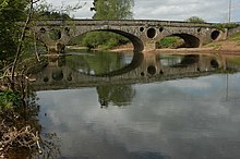
masonry. The central arch is larger, one of the flanking arches is dry and forms a
210:
62:
143:
124:
243:
230:
190:"Pant-y-Goitre Bridge, with approach embankments and flood arches, Llanover"
166:
116:
102:
151:
147:
66:
50:
150:
are pierced by three large circular tunnels. A further tunnel in the
139:
38:
154:
gives additional flood protection and also acts as a cattle creep.
17:
70:
61:
Llanvihangel Gobion is located approximately 5 miles east of
119:
between
Abergavenny and Usk. It was designed and built by
282:
184:
182:
146:. Flooding is a problem on this river and the
115:The bridge was built around 1821 to carry the
302:
8:
309:
295:
165:lived nearby at the time of his fame with
69:and situated on the B4598 Abergavenny to
273:This article relating to a location in
178:
7:
263:
261:
14:
265:
105:passes close by, crossed by the
101:The location is very rural. The
1:
281:. You can help Knowledge by
127:, who also built the nearby
349:
260:
107:Grade II* listed structure
45:, Wales, lying within the
328:Villages in Monmouthshire
37:) is a village and rural
194:British Listed Buildings
47:administrative community
222:for Llanvihangel Gobion
34:
23:
333:Gwent geography stubs
35:Llanfihangel-y-gofion
21:
244:51.77944°N 2.94793°W
211:St. Michael's church
110:Pant-y-Goitre Bridge
97:Pant-y-Goitre Bridge
22:Pant-y-Goitre Bridge
240: /
27:Llanvihangel Gobion
249:51.77944; -2.94793
24:
290:
289:
138:of red sandstone
65:not far from the
340:
311:
304:
297:
269:
262:
255:
254:
252:
251:
250:
245:
241:
238:
237:
236:
233:
221:
198:
197:
186:
136:segmental arches
134:There are three
129:Llanellen Bridge
348:
347:
343:
342:
341:
339:
338:
337:
318:
317:
316:
315:
258:
248:
246:
242:
239:
234:
231:
229:
227:
226:
217:
207:
202:
201:
188:
187:
180:
175:
163:Harry Llewellyn
160:
158:Harry Llewellyn
99:
83:Carpenters Arms
79:
59:
12:
11:
5:
346:
344:
336:
335:
330:
320:
319:
314:
313:
306:
299:
291:
288:
287:
270:
224:
223:
215:
213:
206:
205:External links
203:
200:
199:
177:
176:
174:
171:
159:
156:
98:
95:
78:
75:
58:
55:
13:
10:
9:
6:
4:
3:
2:
345:
334:
331:
329:
326:
325:
323:
312:
307:
305:
300:
298:
293:
292:
286:
284:
280:
276:
275:Monmouthshire
271:
268:
264:
259:
256:
253:
220:
216:
214:
212:
209:
208:
204:
195:
191:
185:
183:
179:
172:
170:
168:
164:
157:
155:
153:
149:
145:
141:
137:
132:
130:
126:
122:
118:
117:turnpike road
113:
111:
108:
104:
96:
94:
92:
88:
84:
76:
74:
72:
68:
64:
56:
54:
52:
48:
44:
43:Monmouthshire
40:
36:
32:
28:
20:
16:
283:expanding it
272:
257:
225:
193:
161:
133:
114:
100:
91:St Michael's
80:
60:
26:
25:
15:
247: /
219:Map sources
63:Abergavenny
322:Categories
232:51°46′46″N
173:References
144:flood arch
125:Gloucester
121:John Upton
235:2°56′53″W
167:Foxhunter
152:abutments
148:spandrels
103:River Usk
77:Amenities
67:A40 road
57:Location
51:Llanover
140:ashlar
87:church
73:road.
39:parish
277:is a
31:Welsh
279:stub
123:of
71:Usk
49:of
41:of
324::
192:.
181:^
169:.
131:.
112:.
93:.
89:,
53:.
33::
310:e
303:t
296:v
285:.
196:.
29:(
Text is available under the Creative Commons Attribution-ShareAlike License. Additional terms may apply.