31:
47:
54:
248:
woodland surrounding the loch provides a habitat for many species of plants that have become increasingly rare elsewhere in
Scotland due to wetland drainage; of particular note is the presence of four species of
218:. The loch was increased in size by the construction of a dam in 1796; the level was further raised in 1840, and partially rebuilt in 1991. As its current extent, it covers 10 hectares.
334:
238:
398:
46:
93:
403:
30:
286:
227:
207:
75:
278:
358:
282:
35:
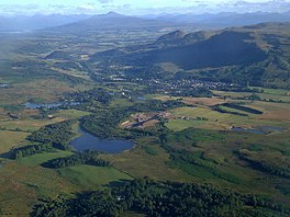
View of
Strathblane and Ben Lomond from the south-east with Loch Ardinning in the foreground
230:. The reserve was established in 1988, and covers 148 hectares. It is classified as a
313:
258:
245:
199:
234:
231:
137:
392:
270:
226:
The loch forms part of the Loch
Ardinning Reserve, which is owned and managed by the
125:
262:
211:
183:
266:
244:
The reserve covers the woodland surrounding the loch, and
Muirhouse Muir. The
108:
95:
274:
257:
in the surrounding area, and provides a habitat for bird species such as
254:
215:
79:
371:"Loch Ardinning in United Kingdom of Great Britain and Northern Ireland"
370:
187:
250:
130:
320:. UK Centre for Ecology and Hydrology - UK Lakes Portal.
179:
175:
167:
159:
151:
147:
136:
124:
85:
71:
23:
210:in Scotland, lying to the south of the village of
86:
239:International Union for Conservation of Nature
8:
335:"Welcome to Loch Ardinning Wildlife Reserve"
20:
329:
327:
253:. Muirhouse Muir is the largest area of
298:
53:
308:
306:
304:
302:
7:
18:Loch in Stirling District, Scotland
14:
206:) is a body of freshwater in the
399:Lochs of Stirling (council area)
52:
45:
29:
166:
158:
150:
1:
70:
404:Freshwater lochs of Scotland
214:near the western end of the
420:
340:. Scottish Wildlife Trust
40:
28:
171:137 m (449 ft)
228:Scottish Wildlife Trust
163:4.5 m (15 ft)
359:Loch Ardinning Reserve
222:Loch Ardinning Reserve
109:55.969584°N 4.296795°W
155:10 ha (25 acres)
208:district of Stirling
114:55.969584; -4.296795
287:grasshopper warbler
105: /
373:. Protected Planet
193:
192:
168:Surface elevation
76:Stirling District
411:
383:
382:
380:
378:
367:
361:
356:
350:
349:
347:
345:
339:
331:
322:
321:
314:"Loch Ardinning"
310:
204:Loch Àird Dùnain
120:
119:
117:
116:
115:
110:
106:
103:
102:
101:
98:
88:
56:
55:
49:
33:
21:
419:
418:
414:
413:
412:
410:
409:
408:
389:
388:
387:
386:
376:
374:
369:
368:
364:
357:
353:
343:
341:
337:
333:
332:
325:
312:
311:
300:
295:
224:
200:Scottish Gaelic
140: countries
113:
111:
107:
104:
99:
96:
94:
92:
91:
67:
66:
65:
64:
63:
62:
61:
57:
36:
19:
12:
11:
5:
417:
415:
407:
406:
401:
391:
390:
385:
384:
362:
351:
323:
297:
296:
294:
291:
235:protected area
223:
220:
196:Loch Ardinning
191:
190:
181:
177:
176:
173:
172:
169:
165:
164:
161:
157:
156:
153:
149:
148:
145:
144:
143:United Kingdom
141:
134:
133:
128:
122:
121:
89:
83:
82:
73:
69:
68:
60:Loch Ardinning
59:
58:
51:
50:
44:
43:
42:
41:
38:
37:
34:
26:
25:
24:Loch Ardinning
17:
13:
10:
9:
6:
4:
3:
2:
416:
405:
402:
400:
397:
396:
394:
372:
366:
363:
360:
355:
352:
336:
330:
328:
324:
319:
318:eip.ceh.ac.uk
315:
309:
307:
305:
303:
299:
292:
290:
288:
284:
280:
276:
272:
268:
264:
260:
256:
252:
247:
242:
240:
236:
233:
229:
221:
219:
217:
213:
209:
205:
201:
197:
189:
185:
182:
178:
174:
170:
162:
160:Average depth
154:
146:
142:
139:
135:
132:
129:
127:
123:
118:
90:
84:
81:
77:
74:
48:
39:
32:
27:
22:
16:
375:. Retrieved
365:
354:
342:. Retrieved
317:
243:
225:
203:
195:
194:
152:Surface area
15:
232:Category IV
212:Strathblane
184:Strathblane
180:Settlements
112: /
87:Coordinates
393:Categories
293:References
267:red grouse
97:55°58′11″N
377:2 October
344:2 October
279:stonechat
100:4°17′48″W
275:whinchat
216:Campsies
80:Scotland
72:Location
283:skylark
237:by the
188:Mugdock
285:, and
271:linnet
259:curlew
251:orchid
338:(PDF)
263:snipe
138:Basin
379:2018
346:2018
255:muir
246:carr
131:loch
126:Type
395::
326:^
316:.
301:^
289:.
281:,
277:,
273:,
269:,
265:,
261:,
241:.
202::
186:,
78:,
381:.
348:.
198:(
Text is available under the Creative Commons Attribution-ShareAlike License. Additional terms may apply.