86:
56:
42:
531:
93:
63:
1079:
319:
and also supplies other nearby county areas. Boating, fishing, picnicking and hiking take place at the reservoir. No daily private boat launching is permitted. No swimming is allowed. The reservoir has a boat rental and snack shop and is open every day from March 1 to
September 15, and weekends only
314:
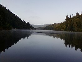
The reservoir is 175 acres (71 ha). It is 2.5 mi (4.0 km) long, 0.25 mi (0.40 km) wide, approximately 150 ft (46 m) deep, with a 9,200 acre⋅ft (11,300,000 m) capacity. It provides a main portion of the drinking water supply for the city of
311:. The dam is an earth-fill barricade, measuring 190 ft (58 m) by 750 ft (230 m). It was financed by bond issuance, and completed in the Fall of 1960; impounded water first ran over the spillway in March 1963.
1342:
323:
Surrounding the reservoir is the Loch Lomond
Recreation Area, which is owned and operated by the City of Santa Cruz Water Department. It has hiking trails, picnic areas, and boating access.
1368:
655:
437:
1258:
465:
1347:
545:
136:
1003:
909:
600:
520:
460:
1378:
410:
475:
85:
853:
55:
806:
715:
560:
771:
879:
430:
378:
1373:
922:
874:
927:
904:
776:
635:
353:
996:
932:
894:
889:
595:
954:
949:
914:
884:
590:
1303:
1223:
1098:
869:
864:
796:
761:
423:
300:
122:
610:
1093:
786:
332:
1053:
989:
735:
720:
570:
1313:
1288:
1228:
1208:
899:
680:
1283:
1243:
970:
837:
605:
400:
276:
1298:
1233:
1142:
811:
17:
1268:
1198:
1132:
832:
781:
695:
615:
316:
1308:
1293:
1273:
1238:
1213:
1160:
395:
192:
16:
This article is about the reservoir in Santa Cruz County. For the populated place in Lake County, see
1329:
1263:
1218:
1165:
827:
640:
446:
292:
118:
1253:
1203:
1170:
1137:
1114:
801:
296:
1278:
1248:
1193:
700:
515:
510:
180:
303:. Part of the Santa Cruz Water Department system, it was created by building the Newell Creek
1188:
1063:
1012:
766:
705:
575:
308:
173:
1078:
1058:
685:
670:
625:
480:
1043:
710:
690:
675:
585:
485:
41:
1033:
1028:
740:
630:
550:
405:
204:
1362:
791:
745:
725:
505:
495:
210:
168:
530:
1068:
1048:
665:
645:
580:
565:
555:
500:
490:
470:
21:
730:
660:
620:
151:
138:
288:
415:
401:
U.S. Geological Survey
Geographic Names Information System: Loch Lomond
277:
U.S. Geological Survey
Geographic Names Information System: Loch Lomond
181:
193:
354:"California exempts Santa Cruz from emergency water use restrictions"
981:
985:
419:
304:
1322:
1179:
1151:
1123:
1107:
1086:
1019:
963:
846:
820:
754:
538:
453:
272:
268:
260:
252:
244:
236:
228:
220:
216:
203:
191:
179:
167:
128:
114:
34:
129:
997:
431:
8:
1369:Reservoirs in Santa Cruz County, California
1180:Cities, towns, and census-designated places
1004:
990:
982:
438:
424:
416:
31:
29:Reservoir in Santa Cruz County, California
307:across Newell Creek – a tributary of the
406:Description of Loch Lomond hiking trails
344:
256:9,200 acre⋅ft (11,300,000 m)
807:The Forest of Nisene Marks State Park
7:
92:
62:
14:
1379:Reservoirs in Northern California
1077:
777:Henry Cowell Redwoods State Park
529:
352:Aguilar, David (June 15, 2022).
91:
84:
61:
54:
40:
20:. For the lake in Scotland, see
259:
251:
243:
235:
227:
219:
320:from Labor Day to October 17.
1:
797:San Bruno Mountain State Park
762:Big Basin Redwoods State Park
396:Santa Cruz City Official Site
379:"Loch Lomond Recreation Area"
301:Santa Cruz County, California
123:Santa Cruz County, California
113:
105:Show map of the United States
787:Portola Redwoods State Park
411:Santa Cruz Water Department
333:List of lakes of California
232:0.25 mi (0.40 km)
1395:
15:
1338:
1075:
527:
48:
39:
1374:Reservoirs in California
1022:& submarine features
971:Santa Cruz Mountains AVA
861:El Corte de Madera Creek
838:Skyline-to-the-Sea Trail
606:El Corte de Madera Creek
264:574 ft (175 m)
910:Purisima Creek Redwoods
812:Uvas Canyon County Park
248:150 ft (46 m)
224:3 mi (4.8 km)
18:Loch Lomond, California
782:McNee Ranch State Park
772:Castle Rock State Park
696:San Francisquito Creek
616:Guadalupe Valley Creek
317:Santa Cruz, California
240:175 acres (71 ha)
152:37.10306°N 122.07333°W
75:Show map of California
381:. City of Santa Cruz.
847:Open Space Preserves
828:Bay Area Ridge Trail
641:Little Boulder Creek
447:Santa Cruz Mountains
293:Santa Cruz Mountains
157:37.10306; -122.07333
119:Santa Cruz Mountains
1343:Tourist attractions
854:Bear Creek Redwoods
833:Devil's Slide Trail
802:Sanborn County Park
148: /
915:Rancho San Antonio
701:San Gregorio Creek
516:Santa Teresa Hills
511:San Bruno Mountain
1356:
1355:
1304:San Juan Bautista
1224:Carmel-by-the-Sea
1099:Santa Cruz County
1064:San Lorenzo River
1013:Monterey Bay Area
979:
978:
940:St. Joseph's Hill
767:Butano State Park
716:San Vicente Creek
706:San Lorenzo River
576:Branciforte Creek
539:Rivers and creeks
309:San Lorenzo River
282:
281:
261:Surface elevation
1386:
1152:Cities and towns
1124:Cities and towns
1081:
1059:San Benito River
1006:
999:
992:
983:
686:Pilarcitos Creek
671:Permanente Creek
626:Harrington Creek
533:
481:Montara Mountain
440:
433:
426:
417:
383:
382:
375:
369:
368:
366:
364:
349:
195:
194:Primary outflows
183:
163:
162:
160:
159:
158:
153:
149:
146:
145:
144:
141:
131:
106:
95:
94:
88:
76:
65:
64:
58:
44:
32:
1394:
1393:
1389:
1388:
1387:
1385:
1384:
1383:
1359:
1358:
1357:
1352:
1334:
1318:
1181:
1175:
1153:
1147:
1125:
1119:
1103:
1094:Monterey County
1082:
1073:
1044:Monterey Canyon
1021:
1020:Bodies of water
1015:
1010:
980:
975:
959:
900:Picchetti Ranch
842:
816:
750:
711:San Pedro Creek
691:San Bruno Creek
676:Pescadero Creek
656:Los Gatos Creek
611:Guadalupe River
586:Carbonera Creek
534:
525:
486:Mount Bielawski
449:
444:
392:
387:
386:
377:
376:
372:
362:
360:
351:
350:
346:
341:
329:
207: countries
182:Primary inflows
156:
154:
150:
147:
142:
139:
137:
135:
134:
121:
110:
109:
108:
107:
104:
103:
102:
101:
100:
96:
79:
78:
77:
74:
73:
72:
71:
70:
66:
30:
25:
12:
11:
5:
1392:
1390:
1382:
1381:
1376:
1371:
1361:
1360:
1354:
1353:
1351:
1350:
1345:
1339:
1336:
1335:
1333:
1332:
1326:
1324:
1320:
1319:
1317:
1316:
1311:
1306:
1301:
1296:
1291:
1286:
1281:
1276:
1271:
1266:
1261:
1259:Forest Springs
1256:
1251:
1246:
1241:
1236:
1231:
1226:
1221:
1216:
1211:
1206:
1201:
1196:
1191:
1185:
1183:
1177:
1176:
1174:
1173:
1168:
1163:
1157:
1155:
1149:
1148:
1146:
1145:
1140:
1135:
1129:
1127:
1121:
1120:
1118:
1117:
1111:
1109:
1105:
1104:
1102:
1101:
1096:
1090:
1088:
1084:
1083:
1076:
1074:
1072:
1071:
1066:
1061:
1056:
1051:
1046:
1041:
1036:
1034:Elkhorn Slough
1031:
1029:Antonelli Pond
1025:
1023:
1017:
1016:
1011:
1009:
1008:
1001:
994:
986:
977:
976:
974:
973:
967:
965:
961:
960:
958:
957:
952:
947:
944:
941:
938:
935:
930:
925:
920:
917:
912:
907:
902:
897:
892:
887:
882:
880:La Honda Creek
877:
872:
867:
862:
859:
856:
850:
848:
844:
843:
841:
840:
835:
830:
824:
822:
818:
817:
815:
814:
809:
804:
799:
794:
789:
784:
779:
774:
769:
764:
758:
756:
752:
751:
749:
748:
743:
741:Waterman Creek
738:
733:
728:
723:
718:
713:
708:
703:
698:
693:
688:
683:
678:
673:
668:
663:
658:
653:
648:
643:
638:
633:
631:La Honda Creek
628:
623:
618:
613:
608:
603:
598:
593:
588:
583:
578:
573:
568:
563:
558:
553:
551:Alamitos Creek
548:
542:
540:
536:
535:
528:
526:
524:
523:
518:
513:
508:
503:
498:
493:
488:
483:
478:
473:
468:
463:
461:Black Mountain
457:
455:
451:
450:
445:
443:
442:
435:
428:
420:
414:
413:
408:
403:
398:
391:
390:External links
388:
385:
384:
370:
343:
342:
340:
337:
336:
335:
328:
325:
280:
279:
274:
270:
269:
266:
265:
262:
258:
257:
254:
250:
249:
246:
242:
241:
238:
234:
233:
230:
226:
225:
222:
218:
217:
214:
213:
208:
201:
200:
197:
189:
188:
185:
177:
176:
171:
165:
164:
132:
126:
125:
116:
112:
111:
98:
97:
90:
89:
83:
82:
81:
80:
68:
67:
60:
59:
53:
52:
51:
50:
49:
46:
45:
37:
36:
28:
13:
10:
9:
6:
4:
3:
2:
1391:
1380:
1377:
1375:
1372:
1370:
1367:
1366:
1364:
1349:
1346:
1344:
1341:
1340:
1337:
1331:
1328:
1327:
1325:
1321:
1315:
1314:Scotts Valley
1312:
1310:
1307:
1305:
1302:
1300:
1297:
1295:
1292:
1290:
1289:Pacific Grove
1287:
1285:
1282:
1280:
1277:
1275:
1272:
1270:
1267:
1265:
1262:
1260:
1257:
1255:
1252:
1250:
1247:
1245:
1242:
1240:
1237:
1235:
1232:
1230:
1229:Carmel Valley
1227:
1225:
1222:
1220:
1217:
1215:
1212:
1210:
1209:Boulder Creek
1207:
1205:
1202:
1200:
1197:
1195:
1192:
1190:
1187:
1186:
1184:
1178:
1172:
1169:
1167:
1164:
1162:
1159:
1158:
1156:
1150:
1144:
1141:
1139:
1136:
1134:
1131:
1130:
1128:
1122:
1116:
1113:
1112:
1110:
1106:
1100:
1097:
1095:
1092:
1091:
1089:
1085:
1080:
1070:
1067:
1065:
1062:
1060:
1057:
1055:
1054:Salinas River
1052:
1050:
1047:
1045:
1042:
1040:
1037:
1035:
1032:
1030:
1027:
1026:
1024:
1018:
1014:
1007:
1002:
1000:
995:
993:
988:
987:
984:
972:
969:
968:
966:
962:
956:
953:
951:
948:
945:
943:Stevens Creek
942:
939:
937:Skyline Ridge
936:
934:
931:
929:
926:
924:
923:Russian Ridge
921:
918:
916:
913:
911:
908:
906:
903:
901:
898:
896:
893:
891:
888:
886:
883:
881:
878:
876:
875:Fremont Older
873:
871:
868:
866:
863:
860:
857:
855:
852:
851:
849:
845:
839:
836:
834:
831:
829:
826:
825:
823:
821:Hiking trails
819:
813:
810:
808:
805:
803:
800:
798:
795:
793:
792:Redwood Grove
790:
788:
785:
783:
780:
778:
775:
773:
770:
768:
765:
763:
760:
759:
757:
753:
747:
746:Zayante Creek
744:
742:
739:
737:
736:Waddell Creek
734:
732:
729:
727:
726:Tip Toe Falls
724:
722:
721:Stevens Creek
719:
717:
714:
712:
709:
707:
704:
702:
699:
697:
694:
692:
689:
687:
684:
682:
679:
677:
674:
672:
669:
667:
664:
662:
659:
657:
654:
652:
649:
647:
644:
642:
639:
637:
634:
632:
629:
627:
624:
622:
619:
617:
614:
612:
609:
607:
604:
602:
599:
597:
594:
592:
589:
587:
584:
582:
579:
577:
574:
572:
571:Boulder Creek
569:
567:
564:
562:
559:
557:
554:
552:
549:
547:
544:
543:
541:
537:
532:
522:
519:
517:
514:
512:
509:
507:
506:Mount Umunhum
504:
502:
499:
497:
496:Mount Madonna
494:
492:
489:
487:
484:
482:
479:
477:
474:
472:
469:
467:
464:
462:
459:
458:
456:
452:
448:
441:
436:
434:
429:
427:
422:
421:
418:
412:
409:
407:
404:
402:
399:
397:
394:
393:
389:
380:
374:
371:
359:
355:
348:
345:
338:
334:
331:
330:
326:
324:
321:
318:
312:
310:
306:
302:
298:
294:
290:
286:
278:
275:
271:
267:
263:
255:
247:
239:
231:
223:
215:
212:
211:United States
209:
206:
202:
198:
196:
190:
186:
184:
178:
175:
172:
170:
166:
161:
133:
127:
124:
120:
117:
87:
57:
47:
43:
38:
33:
27:
23:
19:
1284:Moss Landing
1244:Del Rey Oaks
1108:Major cities
1069:Soquel Creek
1049:Pajaro River
1038:
928:Saratoga Gap
905:Pulgas Ridge
681:Peters Creek
666:Naples Creek
650:
646:Llagas Creek
636:Laguna Creek
596:Coyote Creek
581:Butano Creek
566:Bogess Creek
556:Alpine Creek
501:Mount Thayer
466:Crystal Peak
373:
361:. Retrieved
357:
347:
322:
313:
284:
283:
253:Water volume
237:Surface area
199:Newell Creek
187:Newell Creek
26:
1323:Ghost towns
1299:Rio del Mar
1234:Castroville
1143:Watsonville
1039:Loch Lomond
946:Teague Hill
933:Sierra Azul
895:Monte Bello
890:Los Trancos
651:Loch Lomond
591:Clear Creek
546:Adobe Creek
491:Mount Chual
471:Loma Prieta
285:Loch Lomond
221:Max. length
155: /
143:122°04′24″W
130:Coordinates
99:Loch Lomond
69:Loch Lomond
35:Loch Lomond
22:Loch Lomond
1363:Categories
1269:Greenfield
1199:Ben Lomond
1133:Santa Cruz
955:Windy Hill
950:Thornewood
919:Ravenswood
885:Long Ridge
858:Coal Creek
731:Uvas Creek
661:Love Creek
621:Hale Creek
601:Deer Creek
561:Bean Creek
521:Twin Peaks
476:Long Ridge
339:References
273:References
245:Max. depth
229:Max. width
140:37°06′11″N
1309:Sand City
1294:Prunedale
1274:King City
1239:Davenport
1214:Brookdale
1161:Hollister
870:Foothills
865:El Sereno
289:reservoir
174:Reservoir
1330:Glenwood
1264:Gonzales
1219:Capitola
1166:Monterey
1126:50k-100k
1087:Counties
363:June 15,
327:See also
115:Location
1254:Freedom
1204:Boronda
1182:<25k
1171:Soledad
1154:25k-50k
1138:Seaside
1115:Salinas
297:Lompico
291:in the
1279:Marina
1249:Felton
1194:Aromas
1348:AMBAG
1189:Aptos
964:Other
755:Parks
454:Peaks
295:near
287:is a
205:Basin
365:2022
358:KSBW
169:Type
305:Dam
299:in
1365::
356:.
1005:e
998:t
991:v
439:e
432:t
425:v
367:.
24:.
Text is available under the Creative Commons Attribution-ShareAlike License. Additional terms may apply.