31:
47:
54:
416:
657:
347:
366:
includes an area of marshland in the north-west, a total of 217 hectares being protected. The loch and surrounding area is also maintained as a nature reserve by the
94:
79:
46:
359:
667:
652:
284:
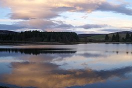
and used as a water supply reservoir as well as an important wildlife site. The loch has been the main water supply for the city of
224:
363:
662:
401:
Bathymetrical Survey of the Fresh-Water Lochs of
Scotland, 1897–1909 Lochs of the Tay Basin Volume II – Loch of Lintrathen
30:
367:
355:
546:
672:
297:
293:
277:
524:
498:
289:
471:
296:, flowing southward past Lintrathen Mill in the ‘Melgam Water’, which has a confluence with the
351:
304:. The loch has a surface area of 151.1 hectares (373 acres) and its dam is an earthworks dam.
245:
315:
loch, which supports large numbers of birds. There are internationally important numbers of
312:
568:
440:
266:
319:, with 3% of the Iceland population over-wintering at the site. Other wildlife includes
324:
281:
646:
420:
340:
316:
301:
126:
320:
308:
624:
399:
336:
262:
237:
109:
96:
258:
447:. Scotland and Northern Ireland Forum for Environmental Research (SNIFFER)
288:
and Angus since 1875. The water in the Loch of
Lintrathen feeds down from
270:
335:
fishing. The fishing is managed by the
Lintrathen Angling Club and both
328:
285:
292:
4 kilometres (2.5 mi) to the north and exits it via sluices at
257:
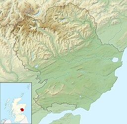
is a man-made loch occupying a glacial basin at the southern end of
599:
332:
419:
This article incorporates text from this source, which is in the
261:, approximately 13 kilometres (8.1 mi) west of town of
280:
lies on the southern shore of the loch, which is owned by
233:
223:
215:
207:
203:
195:
187:
179:
171:
163:
155:
147:
139:
135:
125:
86:
74:
23:
183:423,213,862 cu ft (11,984,082.0 m)
658:Sites of Special Scientific Interest in Scotland
354:, Loch of Lintrathen has also been designated a
87:
8:
300:3 kilometres (1.9 mi) farther south at
466:
464:
462:
435:
433:
431:
429:
404:. National Library of Scotland. p. 122
53:
20:
594:
592:
393:
391:
389:
387:
385:
383:
379:
569:"UK Loch of Lintrathen 13039 RIS 2006"
627:. Joint Nature Conservation Committee
547:"Loch of Lintrathen Wildlife Reserve"
493:
491:
489:
307:Loch of Lintrathen is a mid-altitude
7:
525:"Loch Of Lintrathen Reservoir, Dam"
360:Site of Special Scientific Interest
348:wetland of international importance
14:
346:As well as being recognised as a
604:Ramsar Sites Information Service
576:Ramsar Sites Information Service
445:Centre for Ecology and Hydrology
414:
398:John, Murray; Lawrence, Pullar.
52:
45:
29:
527:. Historic Environment Scotland
214:
206:
194:
186:
178:
170:
162:
154:
146:
138:
1:
73:
175:69.88 ft (21.30 m)
331:, and the loch is used for
211:55.5 °F (13.1 °C)
167:23.29 ft (7.10 m)
689:
246:not a well-defined measure
219:48.0 °F (8.9 °C)
151:1.2 km (0.75 mi)
110:56.68030167°N 3.18285226°W
35:Loch of Lintrathen at dusk
243:
40:
28:
668:Lochs of Angus, Scotland
653:Ramsar sites in Scotland
625:"Loch of Lintrathen SPA"
474:. Gazetteer for Scotland
199:205 m (673 ft)
191:8 km (5.0 mi)
115:56.68030167; -3.18285226
503:Scottish Wildlife Trust
368:Scottish Wildlife Trust
356:Special Protection Area
159:169 ha (420 acres)
143:2 km (1.2 mi)
16:Loch in Angus, Scotland
294:Bridgend of Lintrathen
278:Bridgend of Lintrathen
472:"Lintrathen, Loch of"
276:The small village of
663:Wetlands of Scotland
600:"Loch of Lintrathen"
499:"Loch of Lintrathen"
441:"Loch of Lintrathen"
290:Backwater Reservoir
106: /
255:Loch of Lintrathen
60:Loch of Lintrathen
24:Loch of Lintrathen
352:Ramsar Convention
252:
251:
196:Surface elevation
66:Location in Angus
680:
637:
636:
634:
632:
621:
615:
614:
612:
610:
596:
587:
586:
584:
582:
573:
565:
559:
558:
556:
554:
549:. Cateran Museum
543:
537:
536:
534:
532:
521:
515:
513:
511:
509:
495:
484:
483:
481:
479:
468:
457:
456:
454:
452:
437:
424:
418:
417:
413:
411:
409:
395:
343:are fished for.
244:Shore length is
216:Min. temperature
208:Max. temperature
121:
120:
118:
117:
116:
111:
107:
104:
103:
102:
99:
89:
82:
56:
55:
49:
33:
21:
688:
687:
683:
682:
681:
679:
678:
677:
643:
642:
641:
640:
630:
628:
623:
622:
618:
608:
606:
598:
597:
590:
580:
578:
571:
567:
566:
562:
552:
550:
545:
544:
540:
530:
528:
523:
522:
518:
507:
505:
497:
496:
487:
477:
475:
470:
469:
460:
450:
448:
439:
438:
427:
415:
407:
405:
397:
396:
381:
376:
131:freshwater loch
114:
112:
108:
105:
100:
97:
95:
93:
92:
78:
70:
69:
68:
67:
64:
63:
62:
61:
57:
36:
17:
12:
11:
5:
686:
684:
676:
675:
670:
665:
660:
655:
645:
644:
639:
638:
616:
588:
560:
538:
516:
485:
458:
425:
378:
377:
375:
372:
282:Scottish Water
250:
249:
241:
240:
235:
231:
230:
227:
221:
220:
217:
213:
212:
209:
205:
204:
201:
200:
197:
193:
192:
189:
185:
184:
181:
177:
176:
173:
169:
168:
165:
161:
160:
157:
153:
152:
149:
145:
144:
141:
137:
136:
133:
132:
129:
123:
122:
90:
84:
83:
76:
72:
71:
65:
59:
58:
51:
50:
44:
43:
42:
41:
38:
37:
34:
26:
25:
15:
13:
10:
9:
6:
4:
3:
2:
685:
674:
673:Tay catchment
671:
669:
666:
664:
661:
659:
656:
654:
651:
650:
648:
626:
620:
617:
605:
601:
595:
593:
589:
577:
570:
564:
561:
548:
542:
539:
526:
520:
517:
504:
500:
494:
492:
490:
486:
473:
467:
465:
463:
459:
446:
442:
436:
434:
432:
430:
426:
422:
421:public domain
403:
402:
394:
392:
390:
388:
386:
384:
380:
373:
371:
369:
365:
361:
357:
353:
349:
344:
342:
341:rainbow trout
338:
334:
330:
326:
322:
321:whooper swans
318:
317:greylag geese
314:
310:
305:
303:
302:Airlie Castle
299:
295:
291:
287:
283:
279:
274:
272:
268:
264:
260:
256:
247:
242:
239:
236:
232:
228:
226:
222:
218:
210:
202:
198:
190:
182:
174:
166:
164:Average depth
158:
150:
142:
134:
130:
128:
124:
119:
91:
85:
81:
77:
48:
39:
32:
27:
22:
19:
629:. Retrieved
619:
607:. Retrieved
603:
579:. Retrieved
575:
563:
551:. Retrieved
541:
529:. Retrieved
519:
506:. Retrieved
502:
476:. Retrieved
449:. Retrieved
444:
406:. Retrieved
400:
345:
309:oligotrophic
306:
275:
254:
253:
188:Shore length
180:Water volume
156:Surface area
18:
364:Ramsar Site
313:mesotrophic
234:Settlements
140:Max. length
113: /
88:Coordinates
647:Categories
451:6 December
408:6 December
374:References
350:under the
298:River Isla
263:Kirriemuir
238:Kirriemuir
172:Max. depth
148:Max. width
98:56°40′49″N
80:NO27765487
259:Glen Isla
101:3°10′58″W
631:12 April
609:12 April
581:12 April
508:12 April
271:Scotland
75:Location
553:5 March
531:5 March
478:5 March
225:Islands
362:. The
358:and a
329:osprey
325:otters
286:Dundee
572:(PDF)
337:brown
333:trout
267:Angus
633:2019
611:2019
583:2019
555:2020
533:2020
510:2019
480:2020
453:2020
410:2020
339:and
327:and
127:Type
265:in
649::
602:.
591:^
574:.
501:.
488:^
461:^
443:.
428:^
382:^
370:.
323:,
273:.
269:,
635:.
613:.
585:.
557:.
535:.
514:,
512:.
482:.
455:.
423:.
412:.
311:-
248:.
229:0
Text is available under the Creative Commons Attribution-ShareAlike License. Additional terms may apply.