36:
52:
59:
306:
structure that is presumed to be a house. It is in the form of erect slabs and a slab floor, forming an oval plan. When the loch's water level dropped during the drought of 1980, the house was further exposed and recorded. At that time archaeological artefacts were retrieved from the loch including
338:
is occasionally seen on the loch. In 1960s 50-100 geese were regularly found there in the winter but there has been a sharp decline in numbers since 1974/75 probably as a result of reclamation of moorland and an increase in shooting in the area. The decline at this site matches an increase in the
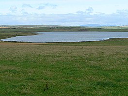
275:. The loch is roughly triangular in shape and is shallow with a flat bottom that gradually deepens from west to east. It lies approximately 4 mi (6.4 km) southeast of
98:
51:
577:"Muckle & Peerie Waters; Loch of Isbister; Loch of Sabiston; Loch of Kirbiste.. - Bathymetrical Survey, 1897-1909 - National Library of Scotland"
608:
240:
322:. It was originally built in the late 19th century and powered by an oil engine. The engine was replaced in the 1940s with a
451:
335:
581:
551:
429:
352:
35:
628:
618:
623:
613:
526:
476:
143:
383:
251:
319:
268:
80:
291:
stand on a short promontory on the southwest shore. It is thought that the broch is the
425:"Bathymetrical Survey of the Fresh-Water Lochs of Scotland, 1897-1909, Lochs of Orkney"
155:
602:
130:
424:
501:
315:
308:
351:
The loch was surveyed in 1903 by R.C. Marshall and later charted as part of the
299:
303:
113:
100:
502:"Loch of Tankerness - Ancient Village or Settlement in Scotland in Orkney"
340:
323:
276:
272:
161:
84:
144:
576:
288:
264:
136:
356:
Bathymetrical Survey of Fresh-Water Lochs of
Scotland 1897-1909
298:
At the edge of the loch, on the eastern shore, is a
239:
235:
227:
219:
211:
203:
195:
187:
179:
171:
167:
154:
142:
129:
90:
76:
23:
91:
527:"Loch of Tankerness filter house and wind pump"
477:"Loch of Tankerness burnt mound and settlement"
8:
18:Freshwater loch in Mainland Orkney, Scotland
378:
376:
374:
372:
370:
215:28,000,000 cu ft (790,000 m)
58:
20:
452:"Loch of Tankerness, Howie of the Manse"
419:
417:
415:
413:
411:
409:
407:
405:
366:
7:
14:
263:is a large, lowland, freshwater
57:
50:
34:
339:size of the wintering flock on
226:
218:
210:
202:
194:
186:
178:
170:
1:
552:"36 Tankerness, Holm, Orkney"
336:Greenland white-fronted goose
75:
609:Freshwater lochs of Scotland
582:National Library of Scotland
556:Greenland Whitefronted Goose
430:National Library of Scotland
645:
314:On the eastern shore is a
252:not a well-defined measure
183:0.5 mi (0.80 km)
249:
223:3.9 km (2.4 mi)
45:
33:
28:
302:. Beside the mound is a
199:4.5 ft (1.4 m)
191:64.1 ha (158 acres)
283:Archaeology and history
175:1 mi (1.6 km)
207:7 ft (2.1 m)
231:8 m (26 ft)
384:"Loch of Tankerness"
114:58.96833°N 2.84361°W
506:The Megalith Portal
110: /
293:Howie of the Manse
261:Loch of Tankerness
119:58.96833; -2.84361
65:Loch of Tankerness
40:Loch of Tankerness
24:Loch of Tankerness
353:Sir John Murray's
287:The remains of a
258:
257:
228:Surface elevation
636:
629:Mainland, Orkney
619:Brochs in Orkney
594:
593:
591:
589:
573:
567:
566:
564:
562:
548:
542:
541:
539:
537:
523:
517:
516:
514:
512:
498:
492:
491:
489:
487:
473:
467:
466:
464:
462:
448:
442:
441:
439:
437:
421:
400:
399:
397:
395:
380:
307:the point of an
250:Shore length is
146:
145:Primary outflows
125:
124:
122:
121:
120:
115:
111:
108:
107:
106:
103:
93:
61:
60:
54:
38:
21:
644:
643:
639:
638:
637:
635:
634:
633:
624:Lakes of Orkney
614:Lochs of Orkney
599:
598:
597:
587:
585:
575:
574:
570:
560:
558:
550:
549:
545:
535:
533:
525:
524:
520:
510:
508:
500:
499:
495:
485:
483:
475:
474:
470:
460:
458:
450:
449:
445:
435:
433:
423:
422:
403:
393:
391:
390:. British Lakes
382:
381:
368:
364:
349:
332:
285:
269:Orkney mainland
158: countries
118:
116:
112:
109:
104:
101:
99:
97:
96:
81:Mainland Orkney
72:
71:
70:
69:
68:
67:
66:
62:
41:
29:Tankerness loch
19:
12:
11:
5:
642:
640:
632:
631:
626:
621:
616:
611:
601:
600:
596:
595:
568:
543:
518:
493:
468:
443:
401:
365:
363:
360:
348:
345:
331:
328:
284:
281:
256:
255:
247:
246:
243:
237:
236:
233:
232:
229:
225:
224:
221:
217:
216:
213:
209:
208:
205:
201:
200:
197:
193:
192:
189:
185:
184:
181:
177:
176:
173:
169:
168:
165:
164:
159:
152:
151:
148:
140:
139:
133:
127:
126:
94:
88:
87:
78:
74:
73:
64:
63:
56:
55:
49:
48:
47:
46:
43:
42:
39:
31:
30:
26:
25:
17:
13:
10:
9:
6:
4:
3:
2:
641:
630:
627:
625:
622:
620:
617:
615:
612:
610:
607:
606:
604:
584:
583:
578:
572:
569:
557:
553:
547:
544:
532:
528:
522:
519:
507:
503:
497:
494:
482:
478:
472:
469:
457:
453:
447:
444:
432:
431:
426:
420:
418:
416:
414:
412:
410:
408:
406:
402:
389:
388:British lakes
385:
379:
377:
375:
373:
371:
367:
361:
359:
357:
354:
346:
344:
342:
337:
329:
327:
325:
321:
317:
312:
310:
305:
301:
296:
294:
290:
282:
280:
278:
274:
270:
266:
262:
253:
248:
244:
242:
238:
234:
230:
222:
214:
206:
198:
196:Average depth
190:
182:
174:
166:
163:
160:
157:
153:
149:
147:
141:
138:
134:
132:
128:
123:
95:
89:
86:
82:
79:
53:
44:
37:
32:
27:
22:
16:
586:. Retrieved
580:
571:
559:. Retrieved
555:
546:
534:. Retrieved
530:
521:
509:. Retrieved
505:
496:
484:. Retrieved
480:
471:
459:. Retrieved
455:
446:
434:. Retrieved
428:
392:. Retrieved
387:
355:
350:
333:
313:
309:early plough
297:
292:
286:
260:
259:
220:Shore length
212:Water volume
188:Surface area
15:
316:filter room
300:burnt mound
172:Max. length
135:freshwater
117: /
92:Coordinates
603:Categories
362:References
320:pump house
304:Bronze Age
204:Max. depth
180:Max. width
588:3 January
561:3 January
536:3 January
511:3 January
486:3 January
461:3 January
436:3 January
394:3 January
150:Mill Burn
105:2°50′37″W
102:58°58′6″N
341:Stronsay
330:Wildlife
324:windpump
277:Kirkwall
273:Scotland
162:Scotland
85:Scotland
77:Location
531:Canmore
481:Canmore
456:Canmore
267:on the
241:Islands
347:Survey
289:broch
156:Basin
590:2015
563:2015
538:2015
513:2015
488:2015
463:2015
438:2015
396:2015
334:The
318:and
265:loch
137:loch
131:Type
271:in
605::
579:.
554:.
529:.
504:.
479:.
454:.
427:.
404:^
386:.
369:^
358:.
343:.
326:.
311:.
295:.
279:.
83:,
592:.
565:.
540:.
515:.
490:.
465:.
440:.
398:.
254:.
245:0
Text is available under the Creative Commons Attribution-ShareAlike License. Additional terms may apply.