539:
493:
568:
316:
341:
441:
385:
583:
532:
578:
486:
129:
573:
525:
563:
479:
558:
377:
401:
257:
324:
409:
268:
70:
437:
381:
349:
509:
463:
272:
249:
110:
372:
Sims, James L.; Seymour, George L.; Anderson, Benjamin J. K.; Fairhead, James (2003).
552:
233:
275:
concessions along the Lofa River were granted in the late 1950s and early 1960s.
261:
114:
95:
144:
131:
374:
African-American
Exploration in West Africa: Four Nineteenth-century Diaries
245:
241:
41:
237:
74:
37:
298:
513:
467:
208:
198:
190:
178:
170:
160:
121:
104:
94:
80:
64:
56:
47:
33:
28:
23:
214:(Period: 1979–2015) 18.63 km/a (590 m/s)
508:This article related to a river in Liberia is a
462:This article related to a river in Guinea is a
244:. The river runs southwest through northeastern
436:. Manchester University Press. pp. 72–73.
293:
291:
533:
487:
402:"At last New York has a pair of pygmy hippos"
252:. Historically it has also been known as the
8:
540:
526:
494:
480:
287:
182:10,446 km (4,033 sq mi)
20:
310:
308:
7:
505:
503:
459:
457:
260:enters the Lofa River in Liberia's
14:
267:Indigenous species include the
569:International rivers of Africa
123: • coordinates
1:
48:Physical characteristics
512:. You can help Knowledge by
466:. You can help Knowledge by
162: • elevation
82: • elevation
200: • location
106: • location
66: • location
600:
502:
456:
432:Greenhalgh, Peter (1985).
210: • average
86:940 m (3,080 ft)
248:before draining into the
218:
186:
174:410 km (250 mi)
90:
52:
378:Indiana University Press
584:Liberia geography stubs
342:"Liberia Political Map"
254:Little Cape Mount River
579:Guinea geography stubs
317:"Liberia Physical Map"
434:West African Diamonds
236:originate in eastern
250:North Atlantic Ocean
166:0 m (0 ft)
145:6.57389°N 11.06056°W
16:River in West Africa
141: /
574:Africa river stubs
410:The New York Times
269:pygmy hippopotamus
150:6.57389; -11.06056
71:Macenta Prefecture
564:Rivers of Liberia
521:
520:
475:
474:
232:is a river whose
222:
221:
591:
559:Rivers of Guinea
542:
535:
528:
504:
496:
489:
482:
458:
448:
447:
429:
423:
422:
420:
418:
406:
398:
392:
391:
369:
363:
361:
359:
357:
348:. Archived from
336:
334:
332:
323:. Archived from
312:
303:
302:
295:
211:
201:
156:
155:
153:
152:
151:
146:
142:
139:
138:
137:
134:
83:
67:
21:
599:
598:
594:
593:
592:
590:
589:
588:
549:
548:
547:
546:
501:
500:
454:
452:
451:
444:
431:
430:
426:
416:
414:
404:
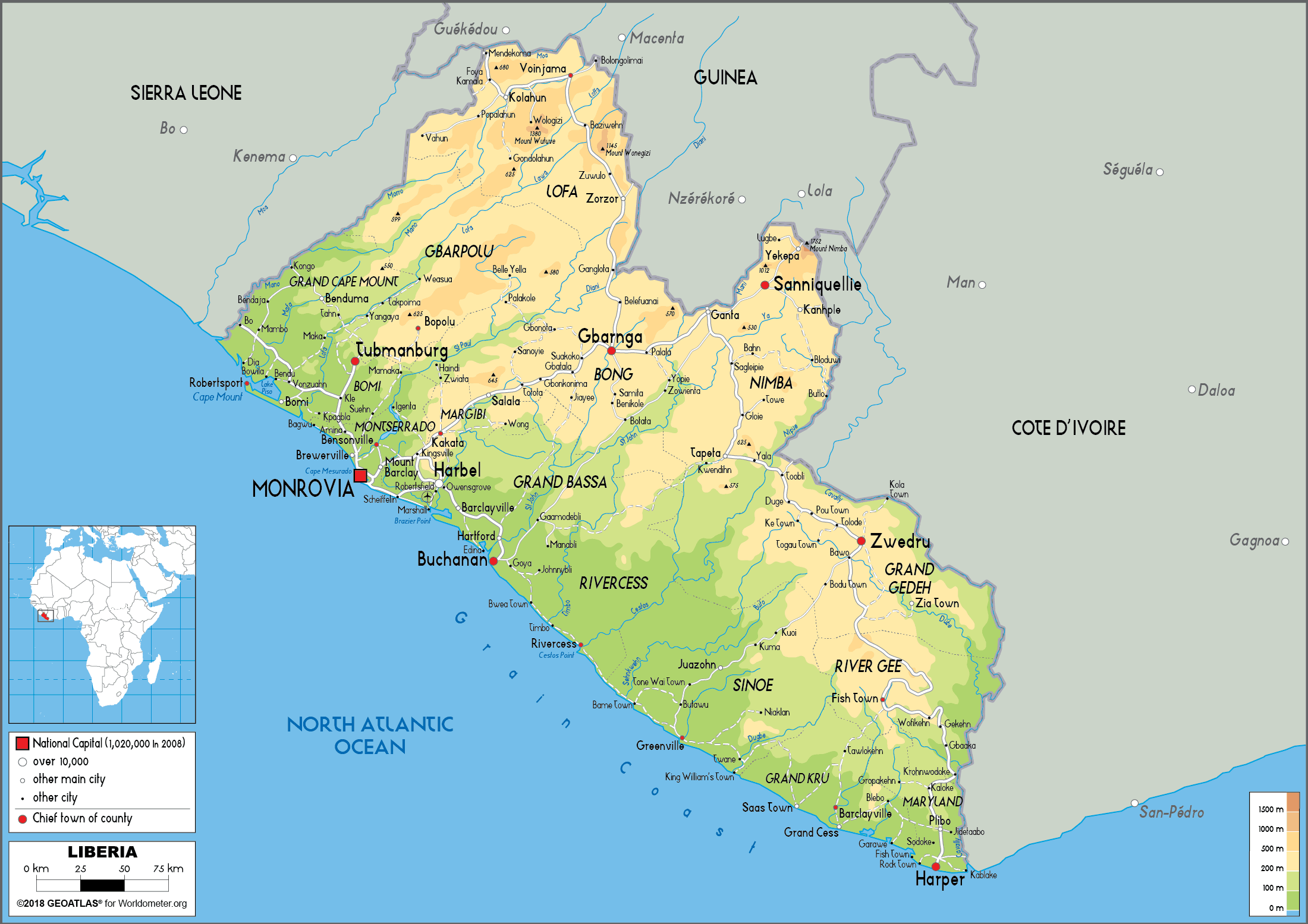
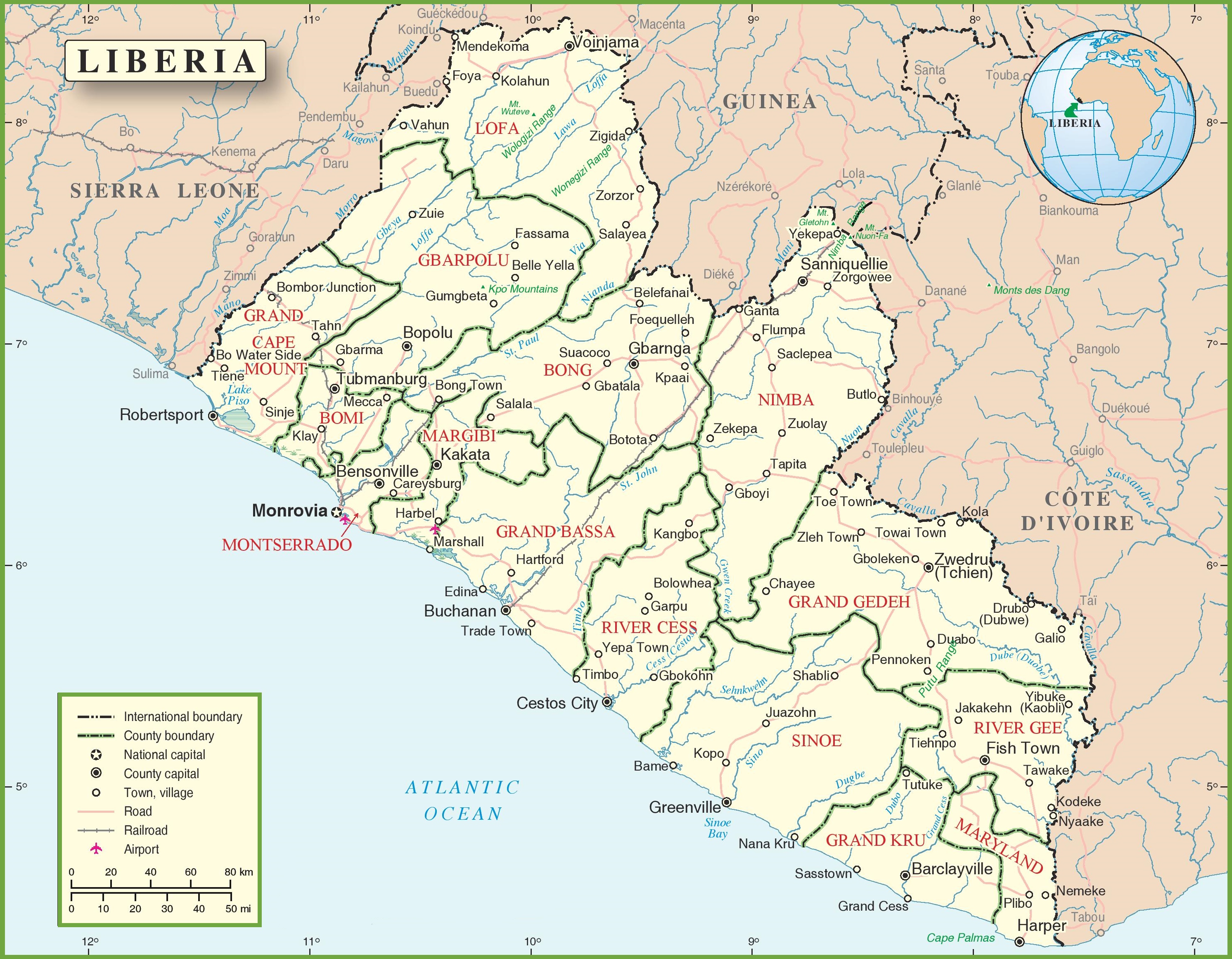
400:
399:
395:
388:
380:. p. 375.
371:
370:
366:
355:
353:
352:on 24 June 2020
340:
338:
330:
328:
327:on 24 June 2020
315:
313:
306:
297:
296:
289:
284:
278:
209:
199:
163:
149:
147:
143:
140:
135:
132:
130:
128:
127:
124:
107:
81:
65:
17:
12:
11:
5:
597:
595:
587:
586:
581:
576:
571:
566:
561:
551:
550:
545:
544:
537:
530:
522:
519:
518:
499:
498:
491:
484:
476:
473:
472:
450:
449:
442:
424:
413:. 14 July 1912
393:
386:
364:
304:
299:"River Basins"
286:
285:
283:
280:
273:diamond mining
220:
219:
216:
215:
212:
206:
205:
202:
196:
195:
192:
188:
187:
184:
183:
180:
176:
175:
172:
168:
167:
164:
161:
158:
157:
125:
122:
119:
118:
111:Atlantic Ocean
108:
105:
102:
101:
98:
92:
91:
88:
87:
84:
78:
77:
68:
62:
61:
58:
54:
53:
50:
49:
45:
44:
35:
31:
30:
26:
25:
15:
13:
10:
9:
6:
4:
3:
2:
596:
585:
582:
580:
577:
575:
572:
570:
567:
565:
562:
560:
557:
556:
554:
543:
538:
536:
531:
529:
524:
523:
517:
515:
511:
506:
497:
492:
490:
485:
483:
478:
477:
471:
469:
465:
460:
455:
445:
443:0-7190-1763-7
439:
435:
428:
425:
412:
411:
403:
397:
394:
389:
387:0-253-34194-9
383:
379:
375:
368:
365:
351:
347:
346:OnTheWorldMap
343:
326:
322:
318:
311:
309:
305:
300:
294:
292:
288:
281:
279:
276:
274:
270:
265:
263:
259:
255:
251:
247:
243:
240:northeast of
239:
235:
231:
227:
217:
213:
207:
203:
197:
193:
189:
185:
181:
177:
173:
169:
165:
159:
154:
126:
120:
116:
112:
109:
103:
99:
97:
93:
89:
85:
79:
76:
72:
69:
63:
59:
55:
51:
46:
43:
39:
36:
32:
27:
22:
19:
514:expanding it
507:
468:expanding it
461:
453:
433:
427:
415:. Retrieved
408:
396:
373:
367:
354:. Retrieved
350:the original
345:
329:. Retrieved
325:the original
321:Worldometers
320:
277:
266:
253:
229:
225:
223:
18:
262:Lofa County
148: /
115:Robertsport
553:Categories
417:12 January
271:. Several
258:Lawa River
234:headwaters
204:Near mouth
179:Basin size
191:Discharge
136:11°3′38″W
133:6°34′26″N
113:south of
34:Countries
29:Location
356:24 June
331:24 June
246:Liberia
242:Macenta
42:Liberia
440:
384:
256:. The
238:Guinea
194:
171:Length
100:
75:Guinea
60:
57:Source
38:Guinea
405:(PDF)
282:Notes
230:Loffa
96:Mouth
510:stub
464:stub
438:ISBN
419:2009
382:ISBN
358:2020
339:(2)
333:2020
314:(1)
226:Lofa
224:The
40:and
24:Lofa
228:or
73:in
555::
407:.
376:.
344:.
319:.
307:^
290:^
264:.
117:at
541:e
534:t
527:v
516:.
495:e
488:t
481:v
470:.
446:.
421:.
390:.
362:.
360:.
337:.
335:.
301:.
Text is available under the Creative Commons Attribution-ShareAlike License. Additional terms may apply.